Thursday, November 17, 2022

THE Surf Report


Having A Ball This Fall

SURF:


No major swells this past week BUT we did have clean water and weather. Been pretty dreamy around here. For the upcoming weekend, we've got more great weather on tap as well as fun surf. 


A storm in the Aleutians a few days ago has sent fun WNW our way for tomorrow and peaking on Saturday. Look for chest high sets Friday afternoon and more consistent chest high surf Saturday. Sunday morning drops to chest high sets but then we MAY see more NW fill in late. 


There's also a chance of waist high+ SW for the OC this weekend but the NW will be dominant. And here's the tides, sun, and water temps for the next few days:
  • Sunrise and sunset for the weekend:
    •  6:22 AM sunrise 
    •  4:46 PM sunset  
  • Water temps are still low 60's and the chilly early mornings aren't helping.
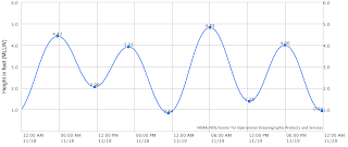
  • And tides are BORING this weekend:
    • 4' at sunrise
    • 2' at lunch
    • and back to 4' at sunset
FORECAST:

Things get interesting next week as the storm track lowers slightly and high pressure lets a few more storms take aim at us- without sending rain. 


The WNW mentioned above for Sunday evening fills in Monday, peaks Tuesday, and holds into Wednesday. Look for shoulder high sets in N County SD and head high surf in southern SD. 


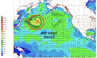
Further out, a good looking storm is forecasted to take shape mid-week and we could see overhead sets from the WNW late next weekend- and possibly the return of the Emergency Board Riding System. About time. 

WEATHER:


Santa Ana winds were a little stronger than I expected yesterday but the recent rains mitigated the fire danger. Unfortunately, we have more Santa Ana winds forming and should arrive Friday into Saturday. Temps through the period should be high 40's at night and high 60's during the day. And the rest of next week looks mellow with no rain in sight. Make sure to follow North County Surf on Twitter!

BEST BET:


Lots of choices here: Saturday with offshore winds and fun WNW. Or Tuesday/Wednesday with better WNW. Or maybe next Sunday withe solid WNW and the EBS in operation?

NEWS OF THE WEEK:


The Pacific islands- Hawaii, Tahiti, Fiji, etc.- have a TON of good waves, but sometimes finding one to yourself is near impossible. But fear not! New waves are being created as we speak. Well actually, it may take a few thousand years before they're rideable, but at least it's a start. Here's the story from NBC News:

A remote undersea volcano is believed to be erupting in Pacific Ocean. Scientists think the Ahyi Seamount's explosions began in mid-October, but it's difficult to confirm because the site, about 3,800 miles west of Honolulu, is so hard to reach.

All indications are that the Ahyi Seamount began erupting in mid-October, the U.S. Geological Survey said Monday. The Northern Marianas are about 3,800 miles west of Honolulu. Scientists are looking to see if the activity is shallow earthquakes or if material exploded from the crater, said Matt Haney, a USGS research geophysicist. Scientists are checking satellite data to see if there’s discolored water, which could suggest material is coming out of the volcano, he said.

“There’s nothing right now that suggests that this eruption will intensify and become a large eruption,” Haney said. Still, mariners would want to avoid the immediate area, he said.


Activity from an undersea volcanic source was picked up last month by hydroacoustic sensors some 1,400 miles away at Wake Island.

With help from the the Laboratoire de Geophysique in Tahiti and data from seismic stations in Guam and Japan, scientists analyzed the signals to determine the source of the activity was probably Ahyi Seamount, the USGS said in a statement.

Activity has been declining in recent days, the statement said.
Ahyi seamount is a large conical submarine volcano. Its highest point is 259 feet below the surface of the ocean. It’s located about 11 miles southeast of the island of Farallon de Pajaros, also known as Uracas.

“There are no local monitoring stations near Ahyi Seamount, which limits our ability to detect and characterize volcanic unrest there,” the agency said. “We will continue to monitor available remote hydrophonic, seismic, and satellite data closely.”

The seamount is part of the Mariana Volcanic Arc, which is a chain of more than 60 active volcanoes stretching over 600 miles west of and parallel to the Mariana Trench, the world’s deepest point.

BEST OF THE BLOG:


Calling our surfers: Time for the next North County Board Meeting Surf Meeting! Good weather has finally returned and we'll be meeting tomorrow- Friday, November 18th. We're going to mix it up this time and get some waves at South Ponto from 7 to 9 AM. So come on down to grab a bite before work, slip into a barrel or two, and learn how you can help the community at our next charity event (which happens to be at Pacific Coast Spirits next month but you'll get the 411 at the Surf Meeting). Look for the tent as usual.

And if you're unfamiliar with the North County Board Meeting, we've been around for 8 years and were created by business professionals who also happen to surf. Our goals are:
  • Encourage the growth of businesses
  • Being a resource for networking
  • Giving back to the community
  • All at the same time making an excuse to surf
You can find out more about our group and events here.

Thanks for the support and we'll see you at Ponto Friday! 

PIC OF THE WEEK:


Took this pic on vacation a few years back. Even though I'm not going back anytime soon, I can't tell you where it's at. Ever see that episode of the Brady Brunch where Greg surfed in Hawaii and wore the voodoo tiki idol around his neck? Don't want that kind of bad karma happening to me. 

Keep Surfing, 
Michael W. Glenn
From Zero To Hero
Announcing My Bid For the 2032 Presidential Election
Most Searched Surfer On AOL

Thursday, November 10, 2022

THE Surf Report


And That's A Wrap!

SURF:

Well, wasn't that impressive. And we're still 6 weeks away from winter! A solid storm wreaked havoc along the Western U.S. and Southern California was no exception. 


As far as the surf went, the storm unfortunately came out the N so we didn't see a lot of groundwell from it- just windswell. The past few days have been cleaner BUT the water's been dirty due to the rain. 


No fear though, by the weekend, we should see cleaner water and a new little SW filling in for Friday/Saturday. We're pretty late in the season, so don't expect much, but spots in far N SD should be waist high with the odd chest high set in the OC. 


SD will get in on the action though by Sunday as NW windswell picks up from a trough moving by to the N. Look for chest high sets and maybe a bit of wind. And here's the tides, sun, and water temps for the next few days:
  • Sunrise and sunset for the weekend:
    •  6:17 AM sunrise (that's early)
    •  4:49 PM sunset (that's early) 
  • Water temps are where they should be this time of year- around 62
  • And tides are this weekend are:
    • 4' at sunrise
    • 5' late morning
    • down to 0' at sunset
FORECAST:


The N Pacific is officially awake. After the NW windswell on Monday, we get a fun NW groundswell on Monday/Tuesday. Look for chest high sets in N County SD and shoulder high waves in southern SD. 


The rest of the week is on the small side but we have WNW swell filling in next weekend for shoulder high surf in N SD and head high surf in S SD. If having to wear a 3/2 is the price to pay for fun NW swells, I'm happy to be broke. 

WEATHER:


What originally looked to be a run of the mill cold front on the forecast charts last week, turned into a full blown barn burner on Tuesday (more on that below). In its wake is cool sunny skies for Friday/Saturday and a bit more clouds/wind on Sunday. Next week we have more cold fronts moving by to the N of us which may give us off and on offshore flow. No real Santa Ana winds but we will have sunny skies most of next week. Temps for the foreseeable future look to be low 60's during the day and high 40's at night. Make sure to follow North County Surf on Twitter!

BEST BET:

Monday/Tuesday with fun NW or next weekend with a better angled WNW for us. 

NEWS OF THE WEEK:


So much for that 'weak' cold front I forecasted for last Tuesday. Within a few days of posting that miscalculation, we were treated with a mid-January haymaker. Here's the report:
  • 6-9" of rain in the San Bernardino Mountains
  • 6-8" of snow at Big Bear
  • 1-1.5" of rain along the SD coast
  • wind gusts of 45 mph along the coast
  • and anywhere between 70-100 mph gusts of wind in the local mountains
  • Sierras also got roughly 4' of snow and most resorts are opening early
Does this mean the drought is over? Nope. Does this mean La Nina is a bust? Nope- but there has been on rare instances where we see above average rainfall during La Nina years. But don't bet the house on it. So where do we stand with rainfall so early in our season?
  • Newport Beach: As of last week, they had 0.48" of rain- only 81% of normal. Now they have 1.59" and are 221% of normal. Take that with a grain of salt though as they're aiming for 11.18" by season's end.
  • Oceanside: As of last week, they had 0.43" of rain- only 62% of normal. Now they have 1.83" and are 226% of normal with a goal of 11.86" to hit 'average' by season's end.
  • San Diego: As of last week, they had 0.16"- just 30% of normal. Now they're at 1.16" and 171% of normal (with average at season's end being 9.79").
No rainfall is forecasted in our near future but some models are hinting storms in the Pacific may push our high pressure aside and we could see rain again Thanksgiving week. Awesome.

BEST OF THE BLOG:


Halloween is in the rearview mirror and we've got more holiday spirit in our sights ahead. The North County Board Meeting is in full swing and the next couple of months are going to be BUSY. In particular:
  • NOVEMBER: Time for our next Surf Meeting! We're going to mix it up this time and get some waves at South Ponto from 7 to 9 AM. Set your calendar for next Friday, November 18th to network, grab a bite before work, slip into a barrel or two, and learn how you can help the community at our next charity event. We'll be just south of the south jetty- look for the tent as usual. And speaking of our next charity event...
  • DECEMBER: We're off to Pacific Coast Spirits in South O'side! If you haven't been there yet, you're missing out; great food, great drinks, and great atmosphere. Here's your chance though: Our annual holiday party & charity event will be Thursday, December 15th from 6 to 9 PM. This season we'll be benefiting Sea Trees; helping to protect and restore ocean health (which is important to your health too)! Cost is just $100 per person and includes, appetizers, dinner, and 2 drinks. As usual, space is limited- and we sold out early last year- so reserve your spot asap as it's first come, first serve! To secure your ticket, reach out to either:
    • Rich Clark, rclark@fuzionpayments.com 
    • Michael Glenn, northcountyboardmeeting@gmail.com
In addition to celebrating the holidays at Pacific Coast Spirits, we'll also be having a live auction to benefit Sea Trees- so get ready to battle it out for some great holiday gifts! 

And if you're unfamiliar with the North County Board Meeting, we've been around for 8 years and were created by business professionals who also happen to surf. Our goals are:
  • Encourage the growth of businesses
  • Being a resource for networking
  • Giving back to the community
  • All at the same time making an excuse to surf
You can find out more about our group and events here.

Thanks for your support and we'll see you November 18th AND December 15th! 

PIC OF THE WEEK:


For Thanksgiving, I'll be spending my time along this wave rich coast. For those of you that know, you know. For those of you that don't, let's just say it's sharky (the big ones- not those little So-Cal juveniles), cold, lots of current, the occasional fog bank, and for good reason- fairly empty. That's why I'm bringing my youngest child with me. Misery loves company! For more inspiring shots of California and beyond, check out Todd Glaser's work here.

Keep Surfing, 
Michael W. Glenn
Top Brass
Already Filled Out My Bracket
Refuse To Surf In A Crowd 

Thursday, November 3, 2022

THE Surf Report


'Tis The Season

SURF:
'Tis the season is a phrase you normally hear in December but I'm breaking it out early. Why? Because 'tis the season for the N Pacific to come alive! Whether you're a fan of snow or storm surf, our fall is starting off with a bang. The Sierras and Rockies are getting snow measured in feet, we've already had a couple cold fronts in So-Cal drops some showers, and our attention has turned from SW swells to NW swells.


The past week started clean before a cold front moved in yesterday and gave us 6-8' bumpy surf last night. 


The NW windswell has since subsided to 1/2 of that, but we do have new smaller SW filling in underneath tomorrow. Look for waist to chest high combo swell on Friday with cleaner conditions. That lasts into Sunday morning. And here's the tides, sun, and water temps for the next few days:
  • Don't forget it's daylight saving time this weekend!
    • Sunrise and sunset for Saturday:
      • 7:10 AM sunrise  
      • 5:54 PM sunset 
    • Sunrise and sunset for Sunday:
      • 6:11 AM (surf before work again!)
      • 4:53 PM (yikes that's early!)
  • Take a guess what the NW wind today did to water temps. You guessed it: Dropped it. Water temps are 65 at best in SD and high 50's in LA! 
  • And tides are this weekend are:
    • 5.5' in the morning
    • 2.5' at after lunch
    • and 4' at sunset
FORECAST:

Even though we haven't received a ton of rain so far this fall (more on that below), it's nice to see a string of low pressure systems moving down the coast so early in the season. With that being said... we have another cold front forecasted to move down the coast. 


As it does, look for the NW windswell to pick up again on Tuesday and last through Thursday possibly. Most spots should be shoulder high. 


Further out, models show another storm forming in the N Pacific which could send us more NW mid-month. We may also see some SW groundswell around that time too. Nothing big, but enough to get the OC into the game. 

WEATHER:


Good to see all these cold fronts coming though our area so early in the season. Not a lot of rainfall (more on that below), but it's keeping the Santa Ana winds away. Look for nice cool sunny skies this weekend with temps near 70 along the coast. By Monday, the clouds thicken as the next low pressure system heads our way. Models hint that we may see showers from Tuesday through Thursday. Not a lot of moisture with this system but I'll take it. If anything changes between now and then, make sure to follow North County Surf on Twitter!

BEST BET:

This weekend with chest high sets from the NW/SW or my personal favorite- storm surf on Wednesday! Which oddly enough, is the same thing I said last week. Eerie. 

NEWS OF THE WEEK:


Even though we're in a La Nina weather pattern (less rain than average forecasted for our winter), the early season cold fronts we've been seeing are a sight for sore eyes. The rain the past few days were only a drop in the bucket, but here's some totals:
  • Upper elevations of the San Bernardino Mountains: 4-8" of snow
  • Lower elevations of the San Bernardino Mountains: 2" of rain
  • SD/OC coastal areas: 0.15-0.25" of rain
Winds were the real story this morning with gusts of:
  • 50-70 mph in the local mountains
  • 35-50 mph along the coast
So where do we stand with seasonal rainfall? (rainy season runs from October 1st to September 30th):
  • Newport Beach: 0.48", 81% of normal
  • Oceanside: 0.43", 62% of normal
  • San Diego: 0.16", 30% of normal
Hopefully with next week's showers (0.25"?), we'll be closer to 100% of normal for Newport, 75% in Oceanside, and 50% in San Diego. But we're still a loooooong way away from the end of the season (September 30th) and nowhere near our average of 10" of rain. But who's counting?

PIC OF THE WEEK:


This set up is easy like Sunday morning. Especially so this Sunday as we'll have an extra hour of sleep! 

Keep Surfing, 
Michael W. Glenn
Triumphant
Celeb
When I Win Powerball I'm Going To Use It All For R&D On A 1 Mil Solar Heated Fullsuit

Thursday, October 27, 2022

THE Surf Report


Trick AND Treat

SURF:


Fun week around here with combo swell, sunny skies, and somewhat manageable winds. For this weekend, it's more of the same. 


For Friday, we'll just have waist high SW/NW before new SW/NW shows up Saturday. Look for chest high surf which lasts into Sunday. And here's the tides, sun, and water temps for the next few days:
  • Sunrise and sunset:
    • 7:04 AM sunrise  
    • 6:00 PM sunset  
  • Water is still nice for this time a year- a couple degrees warmer than 'normal' at 67 degrees.
  • And tides are starting to get extreme as they do this time of year:
    • 3' at sunrise
    • about 5.5' at lunch
    • and 0' at sunset
FORECAST:

The N Pacific is really coming to life while the S Pacific doesn't realize that summer is over. 


Models show a potent low pressure system forming off the Aleutians this weekend which will give us solid head high+ NW Wednesday BUT.. models also show this storm could get close to California and bring rain/wind. Regardless, we should see swell from it- choppy or not. 


We also had a good storm off Antarctica last week which has sent SW our way the middle of next- which could coincide with the N Pacific swell/storm. So we've got waves coming mid-week BUT... could be messy. Forecast charts also show more storms in the N Pacific so we should see more NW late next weekend.  

WEATHER:


Typical fall, huh? The storm track is starting to lower as it should this time of year and the Pacific NW/Northern Rockies have seen snow while we've seen weak cold fronts down here and light offshores/sunny skies behind them. For the weekend, we'll have cool sunny skies with temps in the low 70's. As mentioned above, the storm track may lower a little more and at best we'll see a cold front come through by Wednesday for showers and at worst (which actually is good as we need the water), a low pressure system on top of us with rain and wind. That also means a chance of snow in the local mountains above 7,000'! If anything changes between now and then, make sure to follow North County Surf on Twitter!

BEST BET:

This weekend with chest high sets from the NW/SW or my personal favorite- storm surf on Wednesday! 

NEWS OF THE WEEK:


Tropical storms are well documented and their formation are fairly well understood. Heck- hurricanes even have their own names! Warm tropical water is the fuel for these storms. Not to oversimplify things, but warm air rises of course, so as the warm moisture rises off the oceans- forming thunderstorms- cool air rushes in to replace it- causing wind. And long story short, you get a hurricane in the most extreme conditions.

But how do storms form in cold weather- i.e. Aleutian storms that create our NW swells in winter? Typically, an 'extratropical' storm forms outside of tropical regions- like the N Pacific, despite the phase tropical in its name. These storms are formed when very cold air masses in the upper-levels interact with warm air masses over the sea (e.g., Pacific or Atlantic). As these bodies of cold air collide with warm air bodies, weather fronts form.


As the fronts mature and strengthen, the denser, drier cold air masses move underneath the more buoyant warm air masses and help force the warm air to rise. As a result of this rising air leaving the surface, a low-pressure system forms into a (rapidly) deepening storm. In the northern hemisphere, the winds of these cyclonic systems deflect to the right as a result of the Coriolis Effect (an effect whereby a mass moving in a rotating system experiences a force- the Coriolis force- acting perpendicular to the direction of motion and to the axis of rotation. On the earth, the effect tends to deflect moving objects to the right in the northern hemisphere and to the left in the southern and is important in the formation of cyclonic weather systems).

A further process of warm air rising in the atmosphere starts cooling it and therefore releases its potential energy. The air becomes more buoyant and consequently fuels the storm’s core with even more intense upward movement of air.

At the final stage, this further lowers the pressure at the surface, intensifying the storm. The most organized storms become a so-called bomb cyclones with explosive strengthening of the wind field and rapidly deepening central pressure.


Even though hurricanes get the publicity, extratropical storms from the Aleutians are sometimes more powerful due to their immense size. A storm roared into Alaska last month and an offshore ocean buoy reported waves above 35 feet for 12 hours, peaking at more than 50 feet. Winds gusted over 70 mph for 11 hours- with top speeds of 90 mph. Spots along the Alaska coastline also experienced a storm surge of 11 to 14 feet. Oregon got the wrath of the swell with buoys reporting 40' at 15 seconds, but the storm was aimed towards Alaska, so we only got a glancing blow down here in Southern California last weekend with shoulder high sets.

PIC OF THE WEEK:


Scary enough, this spot is actually in the U.S. and breaks on a fairly regular occurrence in the winter thanks to those extratropical storms we just discussed. Un-happy Halloween everybody! 

Keep Surfing, 
Michael W. Glenn
Aficionado
Mentioned In Prince Harry's Memoir
WSL's 'One To Watch' In 2023

Friday, October 21, 2022

THE Surf Report


Opposites Attract

SURF:

Pleasant weather we're having. And a little bit of combo swell to boot. 


Last couple of days have been pretty fun around here. BUT... if you're a fan of the changing seasons and you can't wait for fall to turn into winter, well... we've got some of that in store for you too. 


A solid storm in the Aleutians earlier in the week sent 40' surf at 15 seconds into the Great White North. The storm unfortunately was pushed into the Pacific NW because of the high pressure that gave us such great weather, but... we will see some surf from it over the weekend. For today, look for just background SW/NW for chest high sets- and the return of fog along the coast. 


For Saturday, a weak cold front will move through JUST as a new SW swell fills in from a solid storm last week off Antarctica. If you don't mind breezy SW winds, look for shoulder high+ surf as more NW fills in late. By Sunday, the cold front should be exiting the region and leaving in its wake NW winds, NW windswell, and still solid SW swell for head high surf. And here's the tides, sun, and water temps for the next few days:
  • Sunrise and sunset:
    • 6:58 AM sunrise  
    • 6:07 PM sunset  
  • Water is now mid-60's
  • And tides are on a bit of a roller coaster ride this weekend:
    • rising to 4.5' at breakfast
    • about 1' at 2 PM
    • and back to 4' at sunset
FORECAST:

The weather cleans up on Monday and we still have shoulder high sets from the SW/NW combo. Mid-week is back to nice weather and smaller surf. 


By Wednesday afternoon, another weak cold front could make it's way to Southern CA again, and as it does- the winds and NW windswell will fill in for chest high surf. That lasts into Friday. 


By Sunday, we may see a small SW fill in for waist high surf in SD and chest high sets in the OC. 


And not to be outdone, models show another storm off Antarctica this weekend which could give us more chest high+ SW towards the first couple days of November. Basically we'll have surf- if the weak cold fronts don't mess anything up. 

WEATHER:


The northern Rockies are getting snow this weekend- up to a 2', and we'll feel the tail end of that system down here on Saturday. Look for the SW winds to increase in the 15-20 mph range by nightfall, a chance of light showers, and then switch to mostly sunny cool skies on Sunday- with breezy NW winds. We should see sun and temps in the mid 50's at night and only mid-60's during the day for Monday to Wednesday. Then ANOTHER weak cold front comes through by Thursday. Welcome to fall. If anything changes between now and then, make sure to follow North County Surf on Twitter!

BEST BET:

This weekend if you like solid surf and solid wind. At least it will keep the crowds down! 

NEWS OF THE WEEK:


As you know, the world’s oceans have been warming for generations. How do I know? As a kid, I never felt 80 degree water temps here in So-Cal, and now it's almost commonplace in the summers. It's a trend that seems to be accelerating and threatens to fuel more supercharged storms, devastate marine ecosystems and upend the lives and livelihoods of millions of people, according to a new scientific analysis.

Published this week in the journal Nature Reviews, it finds that the upper reaches of the oceans — roughly the top 2,000 meters, or just over a mile — have been heating up around the planet since at least the 1950s, with the most stark changes observed in the Atlantic and Southern oceans.

The authors of the review, who include scientists from China, France, the United States and Australia, write that data shows the heating has both accelerated over time and increasingly has reached deeper and deeper depths. That warming — which the scientists said probably is irreversible through 2100 — is poised to continue, and to create new hot spots around the globe, especially if humans fail to make significant and rapid cuts to greenhouse gas emissions.

The findings underscore both the key role the oceans have played in helping to offset human emissions — oceans absorb more than 90 percent of the excess heat trapped within the world’s atmosphere — and also the profound implications if the warming continues unabated. If it does, the areas near the surface of the oceans could warm by two to six times their current temperature, the scientists wrote.

“Global warming really does mean ocean warming,” Kevin E. Trenberth, a co-author of the review and a scholar at the National Center for Atmospheric Research, said in an interview from New Zealand. “The best single indicator that the planet is warming is the ocean warming record.”

That record, composed of thousands of temperature measurements across the globe over decades, he said, shows a “relentless” trajectory. “The warming has been accelerating, and the most rapid warming rates have been in the last 10 years or so,” he said.

The consequences of hotter oceans already are on display in numerous ways. Scientists attribute about 40 percent of global sea level rise to the effects of thermal expansion in ocean water. Warmer oceans also speed the melting of ice sheets, adding to rising seas. They disrupt traditional weather patterns and deepen drought in some areas. And they fuel more intense hurricanes, as well as create the conditions for more torrential rainfall and deadly flooding.

The authors cite one example from August 2017, when the Gulf of Mexico reached the warmest summertime temperature on record to that point. That same month, Hurricane Harvey tore through the gulf, exploding from a tropical depression to a major hurricane and dumping catastrophic amounts of rain on Houston and other areas. “All of these things are part of the fact that there’s extra  energy available” in the oceans, Trenberth said.


In addition, the analysis found that future warming could cause precipitous drops in certain fisheries, causing the loss of livelihoods and food sources. The trend also makes it “inevitable” that marine heat waves will become more extensive and longer-lasting — a reality that can trigger toxic algal blooms and fuel massive mortality events among coral reefs, kelp forests and other ocean life

While the authors make clear that oceans around the world are projected to continue warming over the coming decades, even if humanity begins to cut greenhouse gas emissions, that warming will not happen equally across the globe. Largely due to circulation patterns, some regions are projected to warm faster than others and are likely to grapple with more intense impacts.

The paper also underscores that while many uncertainties remain, how that plays out is “critical” to the consequences humans will probably experience, said Joellen Russell, a professor and oceanographer at the University of Arizona. “A small fraction more [mixing] would slow our warming, and a small fraction less mixing would accelerate our warming,” said Russell, who was not involved in this week’s analysis. “That is incredibly important for people to understand.”

The latest findings are largely in line with the growing body of research has documented — that oceans have long stored astounding amounts of energy from the atmosphere and mitigated the impacts of greenhouse gas emissions, but that over time profound impacts are unavoidable on land and at sea. In its most recent assessment on the state of climate science earlier this year, the Intergovernmental Panel on Climate Change said it is “virtually certain” that the upper swath of the oceans have warmed over the past half-century, and that human-caused carbon emissions are the main driver.

“Global mean sea level has risen faster since 1900 than over any preceding century in at least the last 3,000 years,” the IPCC wrote. “The global ocean has warmed faster over the past century than since the end of the last deglacial transition (around 11,000 years ago).” Still, researchers say the amount of future warming depends on what humans do — or don’t do — to rein-in the greenhouse gases that ultimately are heating oceans. And better measuring, understanding and mitigating the problem should be a global priority.

If the world can steer toward a future with the kind of rapidly shrinking emissions envisioned by the Paris climate agreement, the author of this week’s review write, that would probably “lead to a detectable and lasting reduction in [the] ocean warming rate, with noticeable reductions in climate-change impacts.”
Russell said the latest findings emphasize that it “absolutely matters” that humans cut emissions as quickly as possible, to limit warming in the oceans and the ripple effects that ultimately has for humans. “Our oceans are doing us a profound service,” she said. “As a scientist and a mom, I pray about the fact we need to bend that curve in my lifetime. … It is important that we do this.”

BEST OF THE BLOG:


If you haven't already... MARK YOUR CALENDARS! If you're a surfer that wants to grow their business AND help strengthen our community, The North County Board Meeting's next mixer is this Thursday, October 27th, from 5:30 to 7:30 PM. Being hosted by yours truly, this event marks the unofficial opening of The Co Lab, the newest and coolest creative agency in North County. Formed by Bill McCaffray of Alliance MultiMedia, TJ Smith of Printsmith Solutions, and myself of the North County Board Meeting, we'll be hosting at our new headquarters in Del Mar- right next to Viewpoint Brewing Company. So come on down to see the new space at 2195 San Dieguito Dr. #3 in Del Mar, enjoy a drink on our new patio, grab a bite, and finish off the week at Viewpoint ('cause no one works on Fridays anyway). Make sure to bring a friend and carpool as parking is limited. Thanks for the support! 

PIC OF THE WEEK:


My big wave days are behind me. Actually, I never surfed anything over 20' but all I know is, 1/2 that size feels like a lot nowadays. When I retire, I just want to find some fun waves, no one out, and a pair of trunks that still fit. I think this may be the spot. 

Keep Surfing, 
Michael W. Glenn
Centered
Throwing My Hat In The Ring To Be The UK's Next Prime Minister
Already Working On My Summer '23 Tan