Friday, November 30, 2012

THE Surf Report


Winter is here.

SURF:
Had a slow start to the week but then it kicked into gear on yesterday as a new W swell from a very large and wet storm hit northern California. Luckily for us the storm is staying up north but sending us its' swell.
The W continues to build today and peaks with double overhead surf at best spots in SD and overhead sets in north county SD. North and South OC even get into the act due to the W angle and sees some head high sets. Central OC (like Laguna and Newport) get skunked unfortunately as Catalina blocks most of the swell and just some chest high sets for them. Look for more good surf holding through Monday, albeit a couple feet smaller. Weather should hold with only light showers off and on and light winds. Should be a good weekend of surf.
Beware the tides though- the next few days they're about 3' at sunrise, 6' mid-morning, and down to -0.5' at sunset. Water temps are still holding in the low 60's and getting colder. Make sure to keep up to date on the waves/weather at Twitter/North County Surf.

FORECAST:
After the solid W this weekend, we get some leftovers on Monday for head high sets in SD. There's not a lot on the charts in the near term and Tuesday/Wednesday look small. We get a little bump from the NW on Thursday though for chest high sets. Long term it looks like the north Pacific will come back to life but for next week don't expect much.
The southern hemisphere doesn't look like much either- we have a small storm trying to flare up early next week but best case would be waist high+ SW for the OC around the 8th/9th. 

WEATHER:
As mentioned above, there's a massive storm that's been hitting northern California the past few days and will continue to slam it this weekend. 20'+ surf, winds over 50mph, and up to 1/2 foot of rain. A real mess. Luckily for us the storm is moving east to west and we're only getting the underbelly as it slides above us (gross). We'll only get a little chance of showers down here today and again on Sunday. Nothing really to mess up the surf. Next week we get a little more sun to start the work week then a return of low clouds/fog the second half of the week. No real rain in sight and we're WAAAY behind on our rainfall totals unfortunately.

BEST BET:
Good surf all weekend but the peak of the W swell is today so sneak out- or better yet- call in sick!

NEWS OF THE WEEK:
It’s funny how we religiously follow the tides as they dictate if our surf will be firing or not, but do we really know what tides are? NOAA can help shed some light on the matter for us: Tides are long-period waves that roll around the planet as the ocean is "pulled" back and forth by the gravitational pull of the moon and the sun as these bodies interact with the Earth in their monthly and yearly orbits. During full or new moons—which occur when the Earth, sun, and moon are nearly in alignment—average tidal ranges are slightly larger. This occurs twice each month. The moon appears new (dark) when it is directly between the Earth and the sun. The moon appears full when the Earth is between the moon and the sun. In both cases, the gravitational pull of the sun is "added" to the gravitational pull of the moon on Earth, causing the oceans to bulge a bit more than usual. These are called spring tides, a common historical term that has nothing to do with the season of spring. Rather, the term is derived from the concept of the tide "springing forth." Spring tides occur twice each lunar month all year long, without regard to the season. Seven days after a spring tide, the sun and moon are at right angles to each other. When this happens, the bulge of the ocean caused by the sun partially cancels out the bulge of the ocean caused by the moon. This produces moderate tides known as neap tides, which also occur twice a month. NOAA’s tide and tidal current predictions take into account astronomical considerations due to the position of the moon and the sun.

BEST OF THE BLOG:
Al Merrick is playing Santa Claus this week and is unloading some past season's models. Check out the cheap Channel Islands boards (cheap being a relative word of course) at the North County Surf Blog. And of course a mid-week Surf Check and an in depth THE Surf Report - all of that and morin the blog below!  

PIC OF THE WEEK:
Ahhhhh Jamaica. Home of Bob Marley, Usain Bolt, and illegal cigarettes. And some fun surf too. Not the biggest waves but warm water, minimal crowds, and cold Red Stripes. Yeah mon.

Keep Surfing,

Michael W. Glenn
Pied Piper
Powerball Loser
Shaped A Paipo For Pat O'

Thursday, November 29, 2012

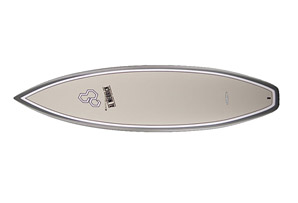
Deal Alert! Channel Islands on the Cheap!

Looking for a special gift this Xmas for a loved one? Thinking about a Channel Islands Surfboard but can't afford full price? Then have I got a deal for you- cheap Channel Islands sticks! Cheap being a relative term of course since full price is around $675. But nonetheless, Al Merrick has put some brand new boards on sale on the CI website for the holidays and you won't have to pay full price. Like the 'White Dove' model shown above. A high performance shortboard designed to fit Tim Curran’s innovative, aerial surfing approach. The White Dove has extreme rocker with a flip both in the nose and tail. The bottom contours are single concave from the nose to the trailing fin. Rails are slightly tapered and the tail is pulled- in which makes for a high performance shortie. Asking price- $525.
Maybe you're looking for something with a little more girth under your feet? Then check out the The MBM+. Working closely with team riders, Al modified the bottom contours to create the MBM +. All our team riders that were riding the MBM are now riding the MBM+ and achieving great results. Nathaniel Curran recently rode the MBM+ to victory at the US Open and the Lacanau Pro in route to qualifying for the 2009 WCT. It consists of a single concave bottom with flip in the tail. The MBM+ is an integral part of CI team riders’ equipment. Another great deal at $525.

Want to surf like Kelly Slater? Good luck with that. No boardshort, wetsuit, or magic potion is going to help with that. But you can ride one of his shapes. The Tangent is the board design that Kelly consistently relied on to get the job done during his 9th world title run with wins in solid surf at Fiji, J-Bay, and Trestles. It consists of single concave and comes with the popular and versatile squash tail or Kelly’s preferred round pin tail. During the quest for a ninth world title, Kelly and Al basically went off on “a tangent” when it came to board design. They tried many formulas which involved one single constant, the rocker. At only $570, you should buy one for a gift and one for yourself!
Now here's a real steal- a prototype from Al Merrick. Born from a Rookie or Remix blank the board has some length taken off the tail and a slight double concave shaped into the single. Looks super fun. Almost like the new Weirdo Ripper but $150 cheaper at $499. This prototype is 6'1 x 18 3/4 x 2 5/16.
 
Not a lot of these boards left so get on these fast at the Channel Islands website!
 

Wednesday, November 28, 2012

Surf Check

It's the calm before the storm. Literally. We've got small SW in the water today for inconsistent waist high sets in far north county and clean cloudy conditions. Then the surf pulls a 180 and comes from the W tonight then NW over the weekend with showers off and on.
In the short term though, look for high tide conditions this morning and pretty much flat surf around town. Winds are light and variable this morning but may switch to the SW tonight from the first weak cold front.
High tide was 6' at 8am this morning, dropping quickly to -1' after 3pm today, and up slightly to 0' at sunset. The quick tide swings will make for some tricky conditions with the upcoming solid surf and showers. All 3 elements will make choosing a good surf session a tough one the next few days.
But let's talk about the good news first. You've probably heard by now we have a solid W swell showing up tomorrow. It's being generated by a big storm off northern California today. Winds in San Francisco are actually forecasted to be 50 mph with higher gusts. They will also get a few inches of rain. A real mess up there. In southern California though, we'll get the tail end of the storm and the first weak cold front will come through tonight. We should get 1/4" of rain and some light south winds. By tomorrow morning, we're should see some head high surf with overhead sets and bigger by sundown. Should be a good swell- if the rain showers don't mess it up too much. It will also be interesting to see the straight W swell and what spots around town will hold their shape- usually we get SW or NW swells so something in-between these swell angles (i.e. W) will be unique. Looks like the solid W swell will peak late Thursday but the storm up north isn't going anywhere anytime soon- so we should have solid overhead surf lasting through Saturday- while the angle of the surf turns more NW. Looks like we get a little dip in the surf heights late Sunday/early Monday but there still should be shoulder high waves. Then another quick reinforcement shows up for head high sets Monday night into Tuesday morning.
The only fly in the ointment is what that big storm up north is going to do to our weather down here. Right now models show it staying to our north while it shoots weak cold fronts our way. If that's the case, we'll get some light rain down here tonight and into Thursday, a slight break Friday, then light showers off and on Saturday/Sunday. If that's the case, it won't mess up our solid surf that much. If the storm doesn't behave as forecasted though and heads our way slightly, we may get more south winds than anticipated and a little more rain. I'm thinking though the storm will behave and our solid surf won't be that jumbled from the wind.
As far as the southern hemisphere goes, it's pretty quiet down there. We have a little storm forecasted to spin this weekend but it's not looking like a good swell maker. If it does come together though, we may have a waist high+ SW for next weekend the 8th.
Long story short- look for big surf late Thursday, dropping slightly but still solid through Saturday, and then a little bump late Monday. Just keep an eye on the sky for S winds/showers. Looks like solid swell though for the next 6 days. Stoke!


Sunday, November 25, 2012

THE Surf Report- Early or Late Edition


Depends on how you look at it.

SURF:
Was on a surf trip up north last week and didn't have much time to get to THE Surf Report. But you already knew it was good around here. Like shooting fish in a barrel.
Today there was some new fun NW filling in for chest high sets around town and shoulder high sets in SD.  Main concern with the swell today (and tomorrow) is the extreme tide swings.
We've got a 6' tide right after sunrise and drops quickly to -1' at 2:30 in the afternoon and back up slightly to 1' at sunset. What currently looked fun will change drastically in about an hour with the rapid tide change. For tomorrow through Wednesday the NW drops off and looks pretty small by Wednesday morning. There's also some small background SW in the water today but it will be gone by the beginning of the week. Water temps are low 60's and a 3/2 fullsuit will suffice. Make sure to keep up to date on the waves/weather at Twitter/North County Surf.

FORECAST:

After the NW backs off the next few days, the north Pacific starts to get back into shape. Currently there's a good storm brewing and it's taking a more southerly track than usual. What will result is a W swell Thursday morning for overhead set waves and some overhead++ surf at the top spots in SD. Should be interesting to see what spots hold with the unique W angle. Unfortunately there's also a weak cold front being generated by the same swell producing storm so we may get light S winds during this swell- all the way through the weekend. Nothing strong but don't expect offshore winds and sunny skies. Once the Thursday swell arrives, some reinforcements show up behind it for surf about the same size- but of a more NW angle- and the good surf should last through Monday morning. Not a bad 2nd half of the week starting to take shape. Just beware the light rain! More on that below...

WEATHER:

As mentioned above, we've got some light rain headed our way- but let's talk about the near term first. For tomorrow we've got more of these stubborn clouds/fog and cool conditions at the beach. Then weak high pressure tries to assert itself on Tuesday for nice weather and that lasts into Wednesday morning. After that we've got a trough of low pressure setting up shop in the northwest and weak cold fronts will rotate around it, taking aim at southern California starting late Wednesday. At this time we should only get light showers and it may last through the weekend. Hopefully it won't screw up the good surf headed our way.

BEST BET:
Hard to say- we've got lots of good surf coming Thursday to Monday but also light showers accompanying the swells. Make sure to pick and choose your windows to surf based on the showers and winds!

NEWS OF THE WEEK:
Now that El Nino has shunned us for the upcoming season, how's our current rainfall situation looking? Here's the latest:
-John Wayne Airport (Newport Beach): 0.58" = 27% of normal
-Oceanside Airport: 1.22" = 58% of normal
-San Diego Lindbergh Field: 0.88" = 56% of normal
Not looking like a good start to the winter. We should get a little rain the 2nd half of this week but it won't be much help. Let's hope Santa brings some storms this December.
PIC OF THE WEEK:

I have no idea where this is. Seriously. A quick search on the internet claims it's in China. But we all know 'Made In China' doesn't produce goods like this. Plus there's like 500 trillion people in China and this line-up doesn't have 1 person out there. It just doesn't add up! Even this pic has me stumped.

Keep Surfing,

Michael W. Glenn
Overseer
Undefeated
Trained With Buzzy For The North Shore Season

Thursday, November 15, 2012

THE Surf Report- Early Edition

El Nino we hardly knew ye...

SURF:

Absolutely gorgeous week we just had at the beach- but no surf. High pressure was in control and kept the storms at bay. Good news is that high pressure is breaking down and letting the storms get closer to us but the great weather is history. I guess you can't have your cake and eat it too (how many times have I said that)? Looks like we get a little bump from the NW on Saturday for chest high surf around town and that holds into Sunday. All in all a little NW this weekend and some showers on Saturday. Better than nothing I guess.
Tides the next few days are 3' at sunrise, almost 7' mid-morning, and down to -1' at sunset. Water temps are in 3/2 fullsuit territory now with 62 degree readings. Make sure to keep up to date on the waves/weather at Twitter/North County Surf.

FORECAST:
After a fairly mild weekend of surf, we get a boost from the NW on Monday that looks to have more chest high+ waves in north county SD and head high sets in SD.
There was also a little storm in the southern hemisphere yesterday which may give the OC some chest high sets towards the 21st and waist high waves down here.
Models also show another storm forming in the Aleutians next week which would give us more chest to head high NW surf in SD county next Friday. Nothing big on the horizon but some fun surf nonetheless.

WEATHER:

After having 80 degree readings at the beaches earlier this week, we got a pretty good cloud cover today and some sprinkles tonight. Look for the clouds to hang around tomorrow and increase a little on Saturday for a chance of showers. The storm track should lift towards Monday and good weather is forecasted for the 2nd half of the week- perfect timing for Thanksgiving.

BEST BET:
Maybe Thursday/Friday of next week as the weather should clear up, we get a new SW on Thursday and a NW on Friday. 4 day weekend anyone?

NEWS OF THE WEEK:

El Nino we hardly knew ye. There were signs last spring of the equatorial Pacific starting to show El Nino type symptoms and if everything came together this fall, we'd have a full blown El Nino this winter- the first in a LONG time. And we could use some big surf and storms around here. Well as luck would have it, the National Oceanic and Atmospheric Administration has updated their latest El Nino report and the synopsis is: Neutral conditions are favored through the Northern Hemisphere winter 2012-13. Meaning: Forget El Nino this winter. Here's the official report from NOAA:

During October 2012, the Pacific Ocean continued to reflect borderline neutral/weak El Niño conditions. Equatorial sea surface temperature (SST) anomalies increased across the Pacific Ocean during the latter half of the month which was also reflected an El Nino forming. The oceanic heat content (average temperature in the upper 300m of the ocean) anomalies also increased slightly in association with a downwelling oceanic Kelvin wave. While the subsurface and surface Pacific Ocean has recently warmed, the tropical atmosphere remained largely consistent with neutral (non-El Nino) conditions. Upper-level and lower-level winds were near average, and the strength of anomalous convection decreased over the past month. Thus, the atmosphere and ocean continue to indicate borderline neutral/ weak El Niño conditions.

Relative to last month, the SST model predictions started strongly favor neutral conditions, although remaining above-average in the Northern Hemisphere for winter 2012-13. While the tropical ocean and atmosphere may resemble a weak El Niño at times, it is now considered less likely that an El Niño will develop. Therefore, the previous El Niño watch has been discontinued as the chance of El Niño has decreased (i.e. Bummer). While the development of El Niño, or even La Niña, cannot be ruled out during the next few months, neutral conditions are now favored through the Northern Hemisphere winter 2012-13.

Long story short- don't look for consistent bombing surf, heavy rain, or the Huntington Beach Pier falling into the ocean this winter.

BEST OF THE BLOG:

The North County Surf Blog has got brand new boards on sale this week. And I'm not talking about just any boards- boards made famous by Curren, Occy, MR, and Tom Carroll (i.e. Channel Islands, Rusty, MR, and Byrne for all of you under 30). And of course a mid-week Surf Check and an in depth THE Surf Report - all of that and more in the blog below!

PIC OF THE WEEK:
Besides France giving us champagne, Bridget Bardot, and Jeremy Flores, it's also given us some of the world's best beach breaks. Like this tubing golden arch. Speaking of golden arches, they also gave us french fries. I think.

Keep Surfing,

Michael W. Glenn
VP of Something Or Other
Nailed My Interview For The CIA Director Position
Rehabilitating The Wounded Gull

Deal Alert! Sticks on Sale!

Seshday is at it again this week with some of the biggest names in surfboards on sale this week. Shapers such as Al Merrick, Rusty Preisendorfer, Mark Richards, and Phil Byrne. And they're built to last with Surtech technology. And did I mention they're on sale?! First up is the 6'1" Flyer from Channel Islands.  The Flyer has been one of the most popular shortboards in the Channel Islands line for year. This board excels in small to medium surf but still rides and responds like a conventional shortboard. Al considers this the best small wave shortboard he has ever designed. It should be ridden 2" to 3" shorter and 1/4" to 1/2" wider than your normal shortboard. For the surfer who wants to maintain the same speed and maneuverability you have on your shortboard in good waves but when the surf is small.

Features:Board Nose Width 11.5"
Board Width 18.75"
Board Tail Width 14.5"
Board Thick 2.25"
Board Volume 27 ccm
Board Fin System: FCS fins included
Board Shaper Al Merrick
Normally this board retails for over $750 but Seshday is giving them away, err, selling them for under $460. Almost $300 off. Nuts. And there's free shipping. Double nuts.
Or maybe you're old school and want a board from the 4 time world champ. Remember when guys on tour used to shape their own boards? Awesome. On sale is an exact replica of Mark Richard's favorite twin designed in 1980. This is the board that brought MR a host of high profile victories. Featuring a deep V bottom and a fluted wing for holding power. Lots of surface area in the forward section of the board for fast paddling and performance in small waves.

Features:
Fins Included LENGTH 6'2"
WIDTH 20.25”
THICKNESS 7.2 cm
NOSE 13.5”
TAIL 15.5”
Board Fin System FCS
Board Shaper Mark Richards
Another steal at $479 considering this board retails at almost $800.
Remember Tom Carroll's infamous 'Snap' at Pipeline? If you don't, then you're under 30 and should be ashamed of yourself. Long story short, Byrne's have been one of Australia's most popular boards for over 30 years and Seshday has them on sale this week for $395. Yes, a brand new world class board for under $400. The HPPB2 from Bryne is basically the same board that was ridden by Phil Macdonald on the WCT. It is definitely for above average surfers. The board is very fast and loose, has a mild concave bottom and squash tail. The 6'1" is best suited to surfers from 130lbs to 170lbs, and designed for surf from 2’ to 6’.

Features:Fins Included
Board Nose Width 11.38"
Board Width 18.5"
Board Tail Width 14.5"
Board Thick 2.38" Board Volume 27 ccm
Board Fin System FCS
Board Shaper Phil Byrne

And last but not least is San Diego's gift to the surfing world, Rusty Preisendorfer (ok, Skip Frye is too but Seshday doesn't have Skips on sale this week. You're going to have to pony up at least a grand for one of those babies). The Rusty Piranha has a similar bottom and rocker to a performance short board but has a fuller nose with the wide point moved forward. Now with 5 fins this is the ultimate shortboard.Overall wider template, low entry rocker and single-to-double concave design make this fishy a greedy little wave magnet. The three-wing, pulled-in swallow tail still allows you to surf vertically. Ride 2-4" shorter than your standard shortboard.

Features: Board Nose Width 14.44"
Board Width 20.81"
Board Tail Width 15.25"
Board Thick 2.44"
Board Volume ccm
Board Fin System FCS
Board Shaper Rusty Preisendorfer
And of course Seshday has slashed the prices on these- from $822 to $479.

So if you're looking for some early season Xmas shopping, head over to Seshday! And did I mention there's free shipping?...

Wednesday, November 14, 2012

Surf Check 11/14/12

Wow is it flat out there. Amazing weather but nothing to ride. Looks like we have some changes coming in the next few days but nothing drastic.
Today though it's knee high around town and maybe towards SD you'll find some waist high sets. Wind is SW at 7 this afternoon and water temps dropped with all that wind last weekend- we're at a chilly 62 degrees.
Tides the next few days are 4' at sunrise, up to 7' mid-morning, and down to -1' around sunset. The tides are killing whatever swell may be out there!
As mentioned above, we have some slight changes coming the next few days. First up- our beautiful weather will be replaced by dense fog tomorrow then overcast conditions Friday through Sunday. We may even see some light showers too.
Of course a weak storm will produce these gray conditions which means it also kicked up a little surf. Should have some shoulder high NW sets on Sunday with head high sets in SD. Nothing big but it will give us waves again. Longer range models show a better NW towards next Tuesday. Our weather should also clean up by then too.
Charts also show a storm brewing in the southern hemisphere today. Looks like 30' seas at it's core which should give the OC some chest high+ waves around the 21st. Might be fun if the forecasted NW shows too AND the weather cooperates!

Thursday, November 8, 2012

THE Surf Report 11/8/12


Batten down the hatches!

SURF:

Fairly nice weather this week and a little bit of NW swell is being replaced tonight by a moderate sized SW and NW swell tomorrow. Unfortunately... we have a solid storm bearing down on us tonight and the NW/SW swell combo will be lost in the jumbled mess that we call stormsurf.
You know me- I love stormsurf- keeps the crowds down- but for everyone else, it's going to be windy, rainy, and confusing Friday and Saturday. If you do want to paddle out, best bet is to wait for the storm to pass on Sunday with leftover NW swell, a touch of SW, and sunny skies. If you can't wait, look for head high junky surf tomorrow and some overhead sets in SD late tomorrow night into Saturday morning.
And if you care about the tides in the middle of all of this, they'll be about 5' at sunrise, down to 1' at noon, and back up to 4' at sunset. And the water is holding in there at 65 degrees. Make sure to keep up to date on the waves/weather at Twitter/North County Surf.

FORECAST:

After a messed up weekend of surf, we get cleaner conditions early in the week and small NW swell. Charts show another storm moving down the coast late Wednesday and by Thursday we're back into shoulder high NW stormsurf. And models show a solid storm forming in the Aleutians late next week which would give us overhead surf from the NW towards late Sunday/Monday the 18th/19th. Bears watching.
There's also a little storm trying to gain some steam in the southern hemisphere around the 15th which may give the OC some chest high sets towards the 21st but don't hold your breath.

WEATHER:

As I mentioned earlier, we've got a storm bearing down on us tonight from Northern California. If it wasn't bad enough the Giants won the World Series, they have to give us their crummy weather too. Look for S winds tomorrow around 20mph+ and rain off an on. Not a big storm but it will be a good start to the season with 1/2" of rain predicted. Saturday is a transition day and by Sunday it's cool and clear around here. Charts show another storm coming our way late next Wednesday. If it pans out, look for a little more rain with this one and a little less wind. Once that exits our region, we should have nice weather next weekend.

BEST BET:
Sunday should have leftover peaky NW swell and clean cool conditions. Water quality may be suspect though- don't say I didn't warn ya!

NEWS OF THE WEEK:

Back on 10/26, the North County Surf blog reported that a little storm named Hurricane Sandy was spinning harmlessly off Florida but had the potential to do some real damage if it met up with a cold low pressure system in the Northeast. Boy did it ever. The LA Times, Accuweather, and NOAA put out some facts this past week about the ‘Superstorm’ that was one for the ages. Dubbed ‘super’ because:
• It reached 900 miles wide
• Caused billions of dollars in damage
• Claimed at least 55 lives.
• Sandy made landfall near Atlantic City, N.J. on October 29 after it transitioned from a tropical to a post-tropical cyclone. The storm had maximum sustained winds of 80 miles per hour and a central minimum pressure of 946 millibars at landfall. This preliminary pressure reading was potentially a record low for the Northeast coast, and is pending further review.
• Sandy's large size, with tropical storm force winds extending nearly 500 miles from the center, led to more than 100 fatalities, large-scale flooding, wind damage, and mass power outages in the Mid-Atlantic and Northeast.
• Sandy brought large storm surge and high water levels to much of the coastal Northeast with New Jersey, New York and Connecticut particularly hard hit. The 13.88-foot observed water level at The Battery in New York City was an all-time record for the location, smashing the previous record set in 1960 during Hurricane Donna by more than three feet.
• The Delaware River in Philadelphia also reached a new record high water level of 10.6 feet, surpassing the previous record of 10.5 feet which was set in April 2011 from record rainfall. This new record was due to a combination of heavy precipitation and storm surge.
• Sandy also brought blizzard conditions to the Central and Southern Appalachians, where over a foot of snow fell in six states from North Carolina to Pennsylvania, shattering all-time October monthly and single storm snowfall records. Snowfall totals across the highest elevations approached three feet.
The scope of the disaster from Sandy is still being measured, but AccuWeather gathered a few hard weather facts.
• Top 3 highest snow amounts from Sandy: 26 inches in Maryland; 24 inches in West Virginia; 13 inches in Pennsylvania.
• Super storm's top 3 highest wind gusts: 94 mph, Eatons Neck, N.Y.; 88 mph, Montclair, N.J.; 86 mph, Westerly, R.I.
• Top recorded wave from Sandy: 39.67 feet at a buoy in the open Atlantic 240 miles west of Bermuda.
• Highest rainfall totals from Sandy: 9.57 inches, Oceania/Virginia Beach, Va.; 8.23 inches, Patuxent River, Md.; 5.57 inches, Atlantic City, N.J.

"Thirty, 40, 50 years from now, people will be talking about Sandy," predicted meteorologist Eric Leister in an interview with The Times on Wednesday morning. There are a few infamous storms over the generations, he said, "For this generation, it's likely that Sandy will be that one that people will always be talking about."
The storm is drawing comparisons in the media to other huge East Coast storms from the past -- including the 1938 storm dubbed the Long Island Express. A 2010 New York Times article recalled "the corpses floating down Main Street ... the boats that drifted into the living rooms of flooded houses." That storm devastated Long Island, killing 50 people there among a total of more than 600.
But AccuWeather meteorologist Leister said that, where Sandy is concerned, there really is no good comparison. It was late in the hurricane season, and yet Sandy became a very organized weather system, taking an unusual track up the East Coast, curving inland. "Most storms are more of a glancing blow," he said, running up alongside the coast. But a trough of low pressure over the Great Lakes pulled Sandy inland, he said. Then there's the storm's sheer size -- clouds from Sandy at one point reached from Detroit to Bermuda, Leister said. The storm hit a massive swath of the U.S. and brought a variety of precipitation and damage, he said: "flooding, rain, devastation of the coast, feet of snow in parts of the Appalachians." Those factors make Sandy truly unique, he said.

Ps- the shot above is of Lake Erie. A lake for cryin' out loud!

BEST OF THE BLOG:

The world title race is heating up and we're hoping Parko finally nabs one. And maybe Taj in '13? And I've still got hope for Robbie Page in '14! Anyway, the Pipe Masters will decide the title- the way it should be- December 8th through the 20th- and the North County Surf blog's got the possibilities for Parko, Mick, and Kelly. And of course a mid-week Surf Check and an in depth THE Surf Report - all of that and more in the blog below!

PIC OF THE WEEK:

You know what those guys on the ski are saying? "So psyched! Look at that pit! Ok I'll tow you first." "No, I'll tow YOU first!" "No bro- YOU go first! I insist." "Um, that's not a shark in the wave, is it?..."

Keep Surfing,

Michael W. Glenn
First
Going to a Kegger at the Electoral College
Won the Vans Quadruple Crown of Surfing