Thursday, June 18, 2015

THE Surf Report- Early Edition


The coldest winter I ever spent was my summer in San Diego.

SURF:
Kind of a down week around here. Not much surf and not much sun. Today is the same unfortunately but at least the sun is trying to peek through.
Tomorrow looks the same then late Saturday we should get a little bump from the SW and a little more sun. Nothing big- maybe chest high sets- but at least we can look forward to the first day of summer if nothing else.
Water temps are slowly inching up towards 67 degrees and tides the next few days are -1' at sunrise, up to 4' at noon, down to 2' late afternoon, and up to 4' at sunrise.

FORECAST:

Things are looking up next week. We had a good storm a few days ago that will start arriving on our shores late Monday and peaking on Wednesday with head high sets. Even have some NW windswell on the charts coinciding on Wednesday also. Beachbreaks should be fun.
After that we get some reinforcing little SW swells every few days through the end of the month. Basically fun little surf and average weather. Make sure to keep up to date on the surf by visiting North County Surf on Twitter.

WEATHER:

The summer that never was. Or at least the spring that never was. We are on track for 2 straight months of clouds at the beaches while inland it bakes. Actually had the sun break out in the afternoon at the beaches yesterday and we may have some relief again this weekend, then the clouds return early next week for more clouds/fog at the beaches and cool temps again. Not a good way to start summer!

BEST BET:
Wait until mid-week when we get a better SW groundswell and reinforcing NW windswell.

NEWS OF THE WEEK:

And the race is on! As you’ve probably heard in recent years, there’s been a big push to make surfing available to the inland masses. For one it’s a new avenue to make money in the hospitality industry and secondly it’s a new channel for the surf companies to sell more product (i.e. they’ve run out of surfers on the coast to sell new boardshorts to). So how come wave pools weren’t profitable in the past? First and foremost, the waves sucked (excuse my French). You really weren’t surfing- just bobbing up and down in a pool of 1’ so-called waves. Disney had the business model right with Typhoon Lagoon in Orlando- build a resort and entertainment around it- but you weren’t allowed to surf it- just run into each other on boogie boards for safety reasons. The surf industry, hospitality execs, and some scientists finally put their heads together and figured out that if you build a resort, retail, AND a wave you can surf, there might be some money in it for all involved. That is all coming to a head this summer at Surf Snowdia in England this summer as guys from the Wavegarden are beefing up their technology and launching a 6’ wave August 1st.
On it’s heels closer to home is NLand Surf Park in Austin (Yes- Texas. Home to Dallas Cowboy Cheerleaders, oil, SXSW, and Tim Duncan). And they of course promise 6’ waves also (along with a couple side pools with 1-3’ waves for beginners). First let me say, I applaud their efforts. If they want to build a 6’ wave in the middle of nowhere, I’m all for it. Especially when I have to visit the in-laws for Thanksgiving and I’m landlocked for 4 days- having a 6’ wave at my fingertips is a godsend. So where does that leave us? Well, we’ve all heard the sad story of the Ron Jon Surf Park in Florida that never was, so I’m not getting my hopes up until I see actual 6’ waves being ridden August 1st in the UK. But we’re just 6 weeks away from it happening so I have a glimmer of hope.
Which brings us to today. I’ve seen some press lately about Quiksilver licensing their name to ‘surf’ themed hotels. Seems harmless enough- Quiksilver puts their name on everything- from bed sheets to boardies. And I’d rather stay at a surf themed hotel than one that’s named Motel 6 and most likely a murder occurred the night before. The second part of the story goes on to say they are in negotiations to buy an old golf course in Palm Desert- like the Palm Desert next to Palm Springs- right over the hill from Southern California. The one that’s 105 degrees today while the coast is socked in fog with 65 degree air and water temps. A win-win; we can drive over the hill, get some warm sun finally, and have a cold one by the pool.
And then I read (drum roll please- and you probably guessed already)- the resort/retail complex is being built around a 6’ wave pool. I know, I know, “I’ll believe it when I see it”. But the fact is that the hospitality industry (and surf industry) is willing to take a stab at it finally with Surf Snowdia and NLand Surf Park. My guess is the biggest problem won’t be the waves itself- I think they’ll beef the thing up- especially since Quiksilver is a ‘surf’ company and Bob McKnight is attaching his name to it. I think the biggest issue will be the sustainability of the whole project (i.e. will there be enough people go to the resort and spend money on drinks, retail, hotel rooms, etc. to support the entire complex). My guess is yes since the Palm Springs area is already popular with close to 10 million people in Southern California being within 2-3 hours of drive time and a little festival called Coachella bringing masses to the desert every year. So when will it open?  I have no idea unfortunately. They are still working out the details on the land purchase, then there’s the environmental impact reports, then construction of course, and testing of the wave, blah blah blah. So maybe 3-5 years? Regardless, if I’m using a walker by then, at least my groms will be stoked (and my wife content at the spa).

PIC OF THE WEEK:

Continuing on the Quiksilver theme, I did some snooping around and found out where the inspiration came for their logo. Now that the mystery's solved, I'm off to find the Loch Ness Monster.

Keep Surfing,

Michael W. Glenn
Billionaire Blogger
Just Franchised a Disco Pants and Haircuts Store
Here Today, Gone To Maui

Friday, June 12, 2015

THE Surf Report


Good things come to those that wait.

SURF:

Fun surf this past week. I have to admit, I didn't expect much from the storm that sent us waves earlier in the week but it turned out to be kind of fun. Today we just have leftover waist high SW swell and overcast conditions again.
This weekend looks pretty void of SW swell and the only chance we have to get surf is a little NW windswell on Sunday. At least the weather will clean up (more on that below).
We also have a tropical storm off mainland Mexico today- Carlos- but it's forecasted to hug the coast and never really gain steam- only a minimal hurricane- then die before it reaches Baja. So no surf for us. And all the clouds recently haven't helped our water temps unfortunately as we're sitting in the low to mid 60's up and down the coast.
Tides the next few days are 3' in the mornings, down to 1' at lunch, and jumping up to 5' at sunset.

FORECAST:
No big surf on the horizon but we do have a couple storms on the charts that will send waves our way.
First up is a small storm that will bring SW swell to our shores starting Tuesday afternoon into Thursday. Look for chest high+ waves from that.
Another storm will take shape this weekend and send a better SW swell (like the one we had a couple days ago) around the 22nd of June. After that things slow down BUT... the tropics have been active so maybe we could see a little hurricane surf in the next 10 days. Make sure to keep up to date on the surf by visiting North County Surf on Twitter.

WEATHER:

Take this with a grain of salt, but I remember when we had the last significant El Nino in '97-'98, we had a very similar spring weather pattern- a bunch of weak cold fronts kept coming through and high pressure was no where to be found. As in the case of today (and most of April/May/early June), we have yet another weak low pressure system rolling through that will kick up some showers in the mountains and drizzle at the coast. Luckily for us, weak high pressure should set up by Sunday and we have nice weather- slightly above average air temps- for early next week. Then models again show weak fronts headed our way for late next week. And yes- cool air temps and clouds again.

BEST BET:
Wait until mid-week when we get a new little SW and better weather!

NEWS OF THE WEEK:

I swear El Nino lately has been a lot like the Kardashians- a bunch of hot air and not a lot of substance. And just like the Kardashians, El Nino won’t go away. Even though the atmospheric phenomenon didn’t pan out last winter, it hasn’t given up either. The National Oceanic and Atmospheric Administration (NOAA) and the Climate Prediction Center (CPC) forecasters are now very confident that the event will continue through the fall (over 90% chance) and into the winter (an 85% chance). Why do they believe this? Well for starters, the waters in the equatorial Pacific are warmer than normal- and getting warmer. What has that lead to? 3 tropical storms off Baja just 3 weeks into the season and 2 of them became major hurricanes. For reference, we’re only supposed to average 3-4 major hurricanes a season and the season goes until November 30th. I’m pretty confident we’ll get a few more major hurricanes if we have almost 6 months in the left in the season AND we haven’t hit the peak of our water temps yet. Forecasters are also gaining steam in their confidence now that we’re emerging from the spring barrier (i.e. their prediction of a solid El Nino earlier this year are on track). There’s 2 things they look at when forecasting an El Nino- strength and duration. While it’s harder to predict the strength of the event than it is to predict its duration, forecasters currently favor a “strong” event for the fall/early winter. By “strong” they mean it’s expected that the three-month average sea surface temperature in our region will peak at more than 2.7°F. above normal. 2.7°F may not seem like much of an increase, but when you spread it over the size of the equatorial Pacific, that’s a lot of energy you’re dealing with. Here’s what NOAA and the CPC had to say this week:

What’s happening right now?

During the month of May, forecasters saw increases in a lot of the El Nino indicators. Sea surface temperature anomalies (the departure from average) were up all across the tropical Pacific, and the most recent reading was 2.1°F above average. Both the lower-level and upper-level winds along the equator were substantially weaker than average last month, characteristic of El Niño’s weakened Walker Circulation. This feedback between the higher sea surface temperature anomalies and the atmosphere is critical to both perpetuating and strengthening an El Niño event, and to communicating the effects of El Niño to other areas of the globe.

Signs of another downwelling Kelvin wave have begun to appear in the upper levels of the equatorial Pacific. This reinforcing source of warmer-than-average waters (i.e. Kelvin wave) follows the strong Kelvin wave that has been slowly moving east since February. The consistently warmer waters are reflective of the slower changes we’d expect to see when the ocean-atmosphere system has settled into an El Nino event, as opposed to the shorter-term changes that dominate the rest of the time.

What signs are suggesting a possible strong event?

The physical observations described above are a source of confidence that this event is continuing to build. Also, most climate models are forecasting a continued increase in the equatorial sea surface temperature anomalies, and many forecast a peak in the early winter above 2.7°F (and even some above an absurd 3.6°F).

It’s important to remember, though, that we only have a handful of strong El Niño events in the historical record—seven since 1950. And only three of those saw values of 3.6°F or higher: 1972-73, 1997-98 and 1982-83). Imagine if we’d only had seven hurricanes in the history of record-keeping; it would make it much harder to understand and predict how a future hurricane could develop. So, while we’re confident that this El Niño event will continue, there’s still plenty of uncertainty about how it will evolve.

That said… what would a strong event mean?

El Nino impacts on North American weather and climate are most noticeable in the winter. This is largely because winter weather is governed more by large-scale storms closer to home (i.e. Aleutian storms) than summer weather, when local effects (e.g. isolated monsoon thunderstorms) tend to be more important. El Niño events affect the strength and position of the jet stream, and tilt the odds toward more rain than average along the West coast and in the Southeast during the winter.

El Niño loads the dice in favor of certain impacts, but it doesn’t guarantee them. However, stronger events tend to lead to more predictable effects. One forecaster was asked if they should repair the leaks in the roof of their RV before they travel this winter… based on the current trends, the forecaster said it was probably a good idea…

Globally, this El Niño event is likely to lead to higher global temperatures, possibly record-breaking. And as mentioned above, the tropical Pacific hurricane season is already breaking records, while the Atlantic hurricane season is forecast to be quieter than average—both effects linked to El Niño.

Many, many different components are at work in the global climate system, making exact predictions impossible. However, the development of a climate phenomenon like El Niño can make some outcomes more likely than others, which is why we follow it so closely. We’ll keep you posted as this event continues.
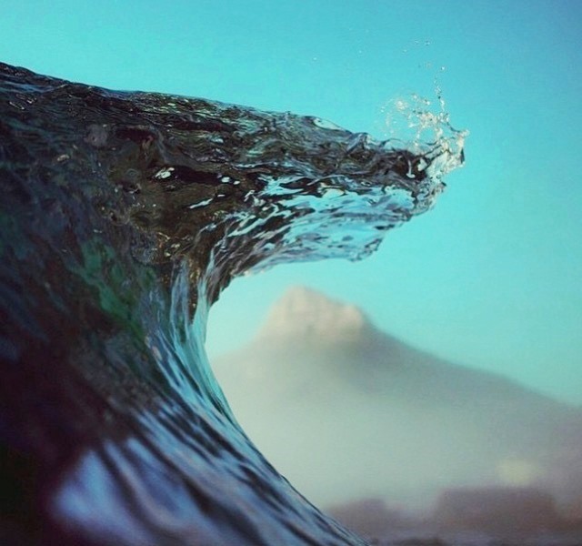
PIC OF THE WEEK:

Got a buddy who's going to this spot in a few months. Don't know why he wants to leave the low clouds, drizzle, cold air temps, crowds, and cool water temps here in San Diego. We got it all!

Keep Surfing,

Michael W. Glenn
More Skill Than Luck
Over Solar. Powering My Home By Moon Beams
Local Anywhere I Paddle Out

Friday, June 5, 2015

THE Surf Report


Let's take it down a notch.

SURF:

Solid hurricane Andrew S swell earlier in the week for the OC was replaced by solid southern hemisphere SW swell for north San Diego county. All the while the June Gloom and S winds hung around at the beaches. Today we have leftover chest high SW swell with a touch of NW windswell (as well as June Gloom again) and S winds already at 8 mph. Tomorrow looks to be the same with even smaller SW swell. By Sunday it's flat- but we should have more sunshine!
With all the clouds, water temps are hanging around the 65 degree mark and tides the next few days are almost -1' at sunrise, up to 3.5' after lunch, and down again to 2' late afternoon. For a more detailed THE Surf Report and a mid-week Surf Check, check out the blog below!

FORECAST:

After a small weekend of surf, we get a little S bump from a storm off Antarctica last week. Look for chest high sets Monday to Wednesday.
Hurricane Blanca is still spinning below Baja at 100 mph (and only forecasted to peak now at 110 mph) so we won't get any surf from it unfortunately as it hides behind the tip of Cabo.
After that, no real storms are on the charts except a modest blip on the radar early next week that may send more chest high SW surf towards the 18th. Our only hope in the short term is another hurricane. Make sure to keep up to date on the surf by visiting North County Surf on Twitter.

WEATHER:

Boy, May Gray and June Gloom are really putting a hold on summer around here. We have yet another weak low pressure system above us today (how many Fridays in a row has that been?) and it will stick around tomorrow. Sunday weak high pressure builds and we get a little more sunshine and temps about 70 at the beaches. That lasts until Tuesday. Then another weak low pressure arrives on Wednesday for more low cloud/fog at the beaches the 2nd half of next week. No real rain in sight and no real sun in sight for the near future either.

BEST BET:
Leftover swell today or more chest high sets and sunnier conditions on Tuesday.

NEWS OF THE WEEK:

Continuing on last week's hurricane theme, I thought it would be a good time for a refresher course. Just what makes a good hurricane? How come all hurricanes off Baja don't send swell our way? Just who are these Saffir-Simpson guys?! Why? Why? Why?  Hopefully the info below makes sense of it all.

First up, what makes a good hurricane? Water temperatures are important of course. A minimum of 82 degrees is required- which usually happens off Mainland Mexico in the summer. Next, add a disturbance in the atmosphere, generally an easterly wave of clouds, formed from winds resulting from the clash between a hot Mainland Mexico land mass and the relatively cooler Pacific Ocean. These waves provide the initial energy and spin required for a hurricane to develop. With the right mix of winds and sea surface temperatures, an ordinary cluster of tropical thunderstorms can explode into a tropical storm. Hurricanes essentially act as engines, drawing energy up from warm tropical ocean waters to power the intense winds, powerful thunderstorms, and immense ocean surges. Water vapor from the warm ocean surface evaporates, forming towering convective clouds that surround the eyewall and rainband regions of the storm. As the water vapor cools and condenses from a gas back to a liquid state it releases latent heat. The released heat warms the surrounding air, making it lighter and promoting more clouds. Because the hurricane-speed winds surrounding the clear eye are often absent from the center of a hurricane, the heaviest rain clouds are pushed out to form a ring around the center, leaving a relatively fair-weather eye.

So now that we have our storm, are we done? Not quite. As with all swell producing storms, you need 4 important factors to make a good one:

1. The size of the storm (i.e. a storm the size of California will make a bigger swell than a storm the size of your front yard)

2. Duration of the wind (i.e. if you get a wind gust of 50 mph, you won't get lots of surf, but if you get 50 mph winds blowing for 4 days, it will keep building bigger swell)

3. Strength of wind (i.e. 5 mph wind won't give you enough energy to make good surf as well as 50 mph wind)

4. Direction the storm/winds are moving/aimed (i.e. if a storm is headed towards us, the energy from the winds will be stronger. If it's moving away, the impact will be less)


Are we there yet? Not quite. There is a 5th factor. Swell angle is just as important as all the other items above. If a storm doesn't have an unobstructed view of us, the swell will be diminished (or non-existent). Makes sense. How come we don't get surf from hurricanes in the Atlantic? It would have to travel south around Cape Horn in South America then come back up to us in California. An exaggeration of course, but even something like the Baja Peninsula getting in the way will block a majority of a hurricane's swell from bending around the coastline and reaching us. Like in the case of Hurricane Andres and Hurricane Blanca this week; Andres had a clear view of California and Blanca has been hiding behind Baja.


So now that we know the ingredients, how are hurricanes classified? You've probably heard the terms Category 1 hurricane or even monsters like a Category 5. Most meteorologists in North America use the Saffir-Simpson scale. The scale was developed in 1971 by civil engineer Herbert Saffir and meteorologist Robert Simpson. Here's a breakdown of the rankings:

- Category 1: 74-95 mph winds. Minimal damage to structures and trees.

- Category 2: 96-110 mph winds. Well-constructed homes could sustain roofing damage. Small trees uprooted.

- Category 3: 111-129 mph winds. Considered a 'major' hurricane. Homes start to lose their roofs. Many trees snapped or uprooted.

- Category 4: 130-156 mph winds. Considered a 'major' hurricane. In addition to roof loss, homes start to lose their walls. Most trees snapped/uprooted. Most of the area will be uninhabitable for weeks/months.

- Category 5: 157 mph+. Considered the strongest of the major hurricanes. High percentage of homes destroyed. Power may be out for weeks/months.

Now that we've been through Andres and Blanca to start off the season, who's the next up to bat?

  1. Andres
  2. Blanca
  3. Carlos
  4. Dolores
  5. Enrique
  6. Felicia
  7. Guillermo
  8. Hilda
  9. Ignacio
  10. Jimena
  11. Kevin
  12. Linda
  13. Marty
  14. Nora
  15. Olaf
  16. Patricia
  17. Rick
  18. Sandra
  19. Terry
  20. Vivian
  21. Waldo
  22. Xina
  23. York
  24. Zelda

Last and final topic: Has southern California ever been hit by a hurricane? It's up for debate but pretty much the answer is no. Because of our cooler water temperatures (consistently under 82 degrees- the most I've ever seen here is high 70's for about a week in late summers), storms lose their energy source before they hit us. We have had some storms try their darndest and roll into town as tropical storms, but no full fledged hurricanes have been accurately recorded (I don't believe reports from the 1800's).

PIC OF THE WEEK:

Because of the topography in the background of the photo, this wave eerily looks like it could be in southern California. But of course it's not, right? Maybe? Oh what the heck- it is California! Right down the street actually!! I'm on it!!! I'm crazy.

Keep Surfing,

Michael W. Glenn
Robust
Next FIFA President. For A Fee.
Like Spicoli, Bodhi, And Rick Kane Rolled Into 1

Tuesday, June 2, 2015

Surf Check

So much to talk about in so little time. So let's get started...


Had a lot of fun surf recently and a lot of May Gray. Last week there was plenty of SW swell (and overcast skies) and this week there's been overcast skies (again) along with Hurricane Andres S swell. Andres was a beauty with winds peaking at 140mph. Unfortunately Andres peaked last night but the OC still got overhead sets and we had chest high waves down here. 
Fear not as new SW was filling in this afternoon from a good storm off New Zealand last week. Look for head high+ waves in north SD and the OC tomorrow before fading Thursday afternoon into the weekend. 
Tides the next few days are around 0' at sunrise, up to 4' at lunch, down to 2' late afternoon, and up to 5' at sunset. 

As far as our weather goes... more May Gray! We have a veeeeeeery late season cold front forecasted to move through on Thursday and linger into Saturday morning. Look for overcast skies and drizzle. Typical for January, err, I mean June. High pressure should set up early next week for warmer temps in the low 70's and less clouds/fog. We also have another hurricane brewing below Andres- known as Blanca- and winds tonight are around 100mph. And wouldn't you know it, models have Blanca turning into our 2nd Category 4 hurricane late tomorrow/Thursday with winds topping out at 145mph. Pretty unusual to start off the hurricane season with two Category 4 hurricanes. El Nino is right on track. Unfortunately, Blanca will be heading towards Cabo and not in our swell window, so we won't see any swell from it. And hopefully Blanca will die off before hitting Cabo this weekend.

So any swell in the near future? Well, not really. After the good SW this week, things wind down next week and it's looking pretty flat. Models show a storm off New Zealand towards the 12th of June which would give us fun SW swell around the 21st- but that's almost 3 weeks away! Our only hope right now is more hurricanes forming off Baja. So until then, live it up this week!