Friday, May 31, 2013

THE Surf Report


Almost too good to be true.

SURF:
That was about 12 days of fun surf we just had. Warm water temps, head high combo swell, and sunny most days.
Today we mainly have NW windswell in the water with a little background SW for chest high sets. Wind is light from the SE and the sun is hiding behind the low clouds again; hoping to see it break up by mid-day.
The weekend looks to be more of the same with chest high sets primarily from NW windswell and smaller SW swell underneath. Don't worry though- we've got corduroy to the horizon late next week- more on that below.
Water temps are a fantastic 68-70 degrees and the tides the next few days are 2' at sunrise, down to 0' mid-morning, up to 5' late afternoon, and down to 2' at sunset. And if you're wondering, the sun's up early so you can hit it almost at 5:30am now and it's setting around 8pm. Plenty of time to surf for anyone's schedule.  Make sure to keep up to date on the waves/weather at Twitter/North County Surf.

FORECAST:

After a weekend of playful NW/SW, the beginning of the week looks to continue the small but rideable theme. The NW should back off and we're left with just background SW swell.
By late Wednesday we may see signs of a good SW starting to hit our shores that was formed from a BIG storm a few days ago. If all goes according to plan, by Friday we should have sets well overhead in SD and 10' in the OC with the Wedge maybe hitting 20'. Could be one of the bigger SW swells of the last few years. JINX! That swell should last through the weekend. Time to ride the 6'6" finally?!

After that there's a smaller storm on the charts in the southern hemisphere that may give us head high sets around mid-month.

WEATHER:

High pressure has been slowly building the past few days and will continue to do so into the weekend. Unfortunately, as high pressure starts to clamp down on the atmosphere, it may trap the low clouds at the coast. So while inland just a few miles temps may be in the mid-80's, the beaches may have a hard time burning off the clouds and be in the low 70's. Could be worse I guess- June Gloom is notorious for thick clouds/drizzle and south wind. Hoping to see a little more sun at the beaches than what the models are forecasting. High pressure starts to break down the middle of next week and we'll still have low clouds at the coast but it should have an easier time breaking up by mid-day and more seasonal temps.

BEST BET:
If the models hold true, late next week will be a doozy.

NEWS OF THE WEEK:

NOAA has released their latest climate reports. Here's what's going on in the world:
Global Highlights
• The combined average temperature over global land and ocean surfaces for April 2013 was the 13th warmest on record, at 0.52°C (0.94°F) above the 20th century average of 13.7°C (56.7°F).
• The global land surface temperature was 0.71°C (1.28°F) above the 20th century average of 8.1°C (46.5°F), marking the 17th warmest April on record. For the ocean, the April global sea surface temperature was 0.44°C (0.79°F) above the 20th century average of 16.0°C (60.9°F), tying with 2001 and 2009 as the seventh warmest April on record.
• The combined global land and ocean average surface temperature for the January–April period (year-to-date) was 0.56°C (1.01°F) above the 20th century average of 12.6°C (54.8°F), tying with 2009 as the eighth warmest such period on record.

Select national information is highlighted below:
• April 2013 brought the fifth warmest April average maximum temperature on record to Australia since national records began in 1900, at 1.64°C (2.95°F) above the 1961–1990 average. At the state level, Western Australia reported its third highest monthly-averaged maximum temperature (2.41°C/4.34°F above average) and fifth highest monthly-averaged minimum temperature (1.50°C/2.70°F above average). Tasmania was the only state with a below-average monthly maximum temperature (-0.23°C/-0.41°F).
• According to NIWA, April temperatures in New Zealand were "well above average" (more than 1.2°C/2.2°F above the 1971–2000 average) across most of the North Island. April temperatures were "above average" (+0.5°C/+0.9°F to +1.2°C/+2.2°F) across most of the South Island.
• The average April temperature across the United Kingdom was 1.1°C (2.0°F) below the 1981–2010 average, tying with 2012 as the coolest April since 1989.
• As reported by the Icelandic Meteorological Office, all listed observation stations in Iceland had average April temperatures below the 1961–1990 average. Departures from average ranged from -0.7°C (-1.3°F) at Stykkishólmur to -2.1°C (-3.8°F) at Egilsstaðir (fourth coldest in the 58-year period of record at this station).
• The April global sea surface temperature was 0.44°F (0.79°F) above the long-term average, tying with 2001 and 2009 as the seventh warmest April in the 134-year period of record. Temperatures were much warmer than average across the equatorial Atlantic Ocean, northern and southeastern Indian Ocean, and much of the southwestern Pacific Ocean. Near-average sea surface temperatures were observed during April across most of the equatorial Pacific Ocean, with below-average SSTs in the far eastern equatorial Pacific. According to NOAA's Climate Prediction Center, ENSO-neutral conditions continue to be favored into the late Northern Hemisphere summer 2013.

BEST OF THE BLOG:

We're almost to June and you know what that means- Volcom Fiji Pro time! Remember the bombing swell last year? Re-live the glory on the North County Surf blog. And take a look at the swell charts to see what's in store for this year's event. Plus the mid-week Surf Check AND an in-depth THE Surf Report. All of that and more in the blog below!

PIC OF THE WEEK:

Nothing spectacular about this week's pic. Unless you like overhead rights with no one out. Ok, pretty awesome I guess. 

Keep Surfing,

Michael W. Glenn
Benefactor
Riding Shotgun With Bieber
1998 Tidal Bore World Tour Champion

Thursday, May 30, 2013

Volcom Fiji Pro: Bring it.


It's time again for the Volcom Fiji Pro; one of the best contests of all time. Thanks to Globe for kicking off this event back in the mid-2000's. Ever wonder why no one wants a World Championship Tour event in Huntington Beach again? 'Cause it's not Fiji with a tropical island, warm crystal clear water, and solid surf- as in the case of 2012- too solid.


The tour didn't bring their big boy pants in 2012 so a majority of the pros had to sit and watch from the boat as Kohl Christensen, Dave Wassel, Grant Baker, Mark Healey and others got to charge. The pros that were lucky enough to borrow boards- like the Hobgoods, Gudangs, Mick, and John John, showed the potential of the event if everyone had brought their guns.


This year however, Stab Magazine is reporting "There shall be no such excuses made because the top 34 will be prepared. ASP WCT Manager Renato Hickel just sent an email around to everyone on the dream tour, saying this: 'I’m sure most of you are getting ready and prepared, but I still want to send you guys this reminder to come prepared to surf large waves if the conditions are right. So plan to bring the equipment you would want, surfboards and/or flotation vests if you want/need them.'
Luckily for us, they may have big surf to start the event. Currently there's a beast stewing in the southern hemisphere but it's peaking tomorrow. The event starts Sunday, June 2nd so they'll just be getting the tail end of it. I'm still hoping for some 12'+ surf though.
If they don't decide to run a few rounds on the first day of the event, it gets kind of iffy after that. Charts show a smaller storm trying to form around the 5th which would give Tavarua swell towards the 7th- the middle of the waiting period. Regardless, keep your computer tuned into the Volcom Fiji Pro right here!

Tuesday, May 28, 2013

Surf Check


That was a great run of surf the past 11 days. Lots of fun solid SW swell with burst of NW swell to mix it up. And then mostly sunny skies mid-day and water temps in the high 60's. The only downside has been the consistently strong SW winds. If you didn't crack it early or late, the mid-day sessions were pretty blown out.
No complaints though as there was fun surf for everyone and it lasted a darn long time. Today we have fading SW swell and another burst of NW windswell. The low tide this morning is draining the swells and the overcast conditions aren't helping. Still have some shoulder high sets from the combo swells. Wind is currently out of the SE at 5 and the water temps are holding at 68. Clouds may stick around all day as we have a weak cold front coming through (more on that below). Tides the next few days are about -1' at sunrise, up to 4' mid-afternoon, and down to 2' at sunset.
Our weather the next few days looks to be getting better- both from a sun standpoint and SW wind standpoint. Currently we have a weak cold front moving through the mountain west and it's kicking up some NW winds in in our outer waters- resulting in more windswell, low clouds, and S winds again for us. High pressure will start to build tomorrow and the windswell will slowly fade as the sun starts to heat things up. By the weekend we should have temps in the mid to high 70's. The only fly in the ointment is if the high pressure will trap the low clouds/fog at the coast which would result in sunny skies about a mile inland but overcast conditions right at the beach.
As far as the surf goes, we've got NW windswell on tap the next couple days but as high pressure starts to take control, the windswell will begin to back off. The southern hemisphere last week was quiet too and the current SW will fade the next few days. Long story short, the 2nd half of this week into the weekend should be pretty small around here.
There's some N windswell on the charts towards early next week but the angle is almost NE- basically away from us- so I don't expect anything from this source later this week.

Good news is that the models are showing a solid storm forming in the southern hemisphere in a couple days. Bad news is that the swell won't show until around June 6th- almost 10 days from now. So until then, we're left with dying SW/NW today and pretty small conditions this weekend.
Of note is the tropics stirring things up again. We just had tropical storm Alvin flare up a couple weeks ago now we have 2 disturbances off mainland Mexico- one of which may turn into a tropical storm or hurricane. Even if it does turn into a hurricane, it would have to be strong and aim N towards us to give us any sort of waves- pretty early in the season for that to happen. It's at least some sort of hope though since the north Pacific and south Pacific are looking pretty dormant at this point the next few days.


Friday, May 24, 2013

THE Surf Report- late edition


Well wasn't that special.

SURF:
Where to start? The super warm water temps for May? The solid SW swell early in the week? The great beach weather last weekend? The crazy windswell the past few days? The enormous tide swings? Hard to fit it all in 1 surf report. Let's get down to business then.
Plenty of good surf today from a new little SW and leftover smaller NW windswell. Sets most everywhere are head high, the sun is trying to keep the low clouds at bay, wind is SW at 10, and the water temp is a pleasant 67. Can't complain much. Tomorrow is more of the same with slightly smaller surf and by Sunday it's small but fun. All in all fun today and tomorrow morning and small Sunday.
Tides the next few days are about 0' at sunrise, up to 4.5' mid-morning, down to 1' mid-afternoon and up to 6' at sunset. FYI- the peak high tide is about 7.2' around 9pm and down to -1.7' at 3am- that's almost a 9' tide swing. It's like the Bay of Fundy around here. Make sure to keep up to date on the waves/weather at Twitter/North County Surf.

FORECAST:

After the surf backs off on Sunday, it really backs off. Looking pretty small next week as there are no big storms aimed our way. Models hint at some NW windswell towards next Friday but that's about it.
We do though have a solid storm on the charts towards the end of this month in the southern hemisphere but that would give us SW swell almost 2 weeks out- about June 7th- and that's a long time to wait for waves.
There's actually some clouds flaring up off mainland Mexico- but I don't expect it to turn in to a hurricane that would send us surf. So until then, look for small surf in the near future.

WEATHER:

Tough call here. Basically we've had low pressure sitting above us the past few days and weak cold fronts keep coming into the mix. This has resulted in lower than normal temperatures (mid 60's vs. 70 this time of year) and clouds at the beaches that sometimes stick around longer than expected. Long story short, expect more of the same this weekend- night and morning low clouds with a chance of afternoon clearing. Temps will be about 65 again and breezy SW winds should continue. And if that wasn't odd enough, models are showing a stronger cold front for Monday night into Tuesday that could bring us a 1/4" of showers. The 2nd half of next week should return to normal around here with temps near 70, sunnier skies, and less wind.

BEST BET:
Get a surf in tonight before both swells fade away late this weekend!

NEWS OF THE WEEK:

It’s official: The National Oceanic and Atmospheric Administration’s Climate Prediction Center (man is that a long title) has made their first prediction for our upcoming Eastern Pacific hurricane season.

And it sucks.

NOAA’s CPC announced today that a below-normal hurricane season is most likely for the Eastern Pacific this year. The outlook calls for a 55 percent probability of a below-normal season, a 35 percent probability of a near-normal season and a 10 percent probability of an above-normal season. Basically SD county never gets real hurricane surf due to the extreme S angle of most storms (our Orange County brethren get most of the action), so a ‘normal’ hurricane season in north county SD doesn’t amount to much. With this new forecast being a 55% probability of ‘below’ normal activity, man are we due for a flat summer once those southern hemi swells start to die off in July.

NOAA says seasonal hurricane forecasters are calling for a 70 percent chance of 11 to 16 named storms, which includes 5 to 8 hurricanes, of which 1 to 4 are expected to become major hurricanes (Category 3, 4 or 5 on the Saffir-Simpson Hurricane Wind Scale).

 An average Eastern Pacific hurricane season produces 15 named storms, with eight becoming hurricanes and four becoming major hurricanes. The Eastern Pacific hurricane season runs from May 15 through Nov. 30, with peak activity from July through September. Tropical Storm Alvin, the season’s first named storm, developed on May 15.

 The key climate factors behind this outlook are:
•A continuation of the climate pattern responsible for the ongoing era of low-activity for Eastern Pacific hurricanes that began in 1995;

•ENSO neutral (meaning  El Niño or La Niña is unlikely), but with near- or below-average sea surface temperatures in eastern equatorial Pacific Ocean.

“Although a below-normal season is most likely this year, we encourage everyone to get prepared for the start of the season and to check the forecast as storms develop,” said Gerry Bell, Ph.D., lead seasonal hurricane forecaster at NOAA’s Climate Prediction Center, part of the U.S. National Weather Service. “It only takes one storm making landfall in your area to make it a bad year for you, regardless of the overall activity predicted in the seasonal outlook. So residents, businesses, and government agencies of coastal and near-coastal regions should prepare for every hurricane season regardless of the seasonal outlook.”

The outlook is a general guide to the overall seasonal hurricane activity. It does not predict whether, where, or when any of these storms may hit land. Eastern Pacific tropical storms and hurricanes most often track westward over open waters, sometimes reaching Hawaii. However, some occasionally head toward the northeast and may bring rainfall to the arid southwestern United States during the summer or fall. Also, on average, two to three storms per season affect western Mexico or Central America.

BEST OF THE BLOG:

Looking for a few minutes to waste away in your life? Then check out some solid clips of Mason Ho at the Wedge, Josh Kerr putting his 'Neil Diamond' through the paces (in 1' surf and making it look like 6' Lowers), and that 18 year old wonder kid (the next John John I hear) Felipe Toledo. Check out the story on the blog as well as a mid-week Surf Check AND an in-depth THE Surf Report. All of that and more in the blog below!

PIC OF THE WEEK:

Ever heard of Area 51, that super top secret military base in the Nevada desert? Also got their own stealth wave pool technology out there too. Reversed engineered it with the help of those Roswell aliens. Mighty nice of those little green buggers.

Keep Surfing,

Michael W. Glenn
Remarkable
Aquaman
Made A Steve Lis Fish With My 3D Printer

Wednesday, May 22, 2013

Clips of the Day: Toledo, Ho, and Kerr


In case you don't know who Felipe Toledo is, you'll know after watching this clip. He basically throws free surfs into his heats on the World Championship Tour. Once he starts figuring out heat strategy and puts some weight into his turns in real surf like Teahupoo, he could be the 1st Brazilian world champ- him or Gabriel Medina of course. Oh sure Adriano DeSouza is in 1st place in the ratings right now but Kelly, Parko, Mick, and heck- even Jordy finally- will catch him this year. So until then, enjoy this one wave, 10 point ride, during the Billabong Pro Rio from Felipe.

One of my all-time favorites here: Mason Ho. If you're a reader of the North County Surf blog, then you've run across various clips of Mason over the years (like this one that's not even a real wave but Mason somehow makes it look fun). Today's clip of Mason takes him all over the place- like Waimea shorebreak and a wave that I grew up on- the Wedge. Mason shows the kids that there's more to surfing that just air reverses in 2' slop- there's all kinds of interesting waves out there to get loopy on.

And small high performance shortboards have been all the rage the past couple years. Dane Reynolds of course helped bring them to the limelight with the Dumpster Diver and Neckbeard and most shapers now have a dumpy fat little shortboard in their range. Rusty's got the 'Neil' with a diamond tail (catchy, huh?) and local transplant Josh Kerr puts it through it's paces in some gutless tiny surf. Basically he makes it look like he's surfing 6' lowers on a normal 6'2" shortboard.

Tuesday, May 21, 2013

Surf Check

Where do I start with today's Surf Check?! First let me say, it doesn't get much better. We've got solid SW swell hitting our beaches today, the sun is out with temps near 70 and the water is almost 70 degrees too. Who needs Tahiti?! Just kidding of course but it's still looking pretty fun out there.

Currently the SW swell is good for head high+ sets in north county SD with overhead sets towards the OC. Wind is SW at 10 and the crowds are minimal as we've had surf all weekend and everyone is surfed out- or opting to get some work/school done. It's a little lined up out there as the NW isn't big enough to really cross it up but you can find a random corner at the beach breaks if you wait long enough. Tides are 4' at 8am, down to 1' at 2pm, and back up to 6' at sunset.
Our weather is pretty darn good too today but changes are coming. We have a weak low pressure system trying to set up shop for the 2nd half of this week into the weekend. We'll only have temps in the mid-60's at the beaches and the clouds may stick around at the coast this holiday weekend. Hopefully the models are wrong and we at least get some clearing mid-day. All in all nothing unusual for this time of year- that's why they call this time of year 'May Gray' and 'June Gloom' of course.
Even though the weather may turn out to be funky this weekend, the surf will keep rolling. The weak low pressure that's setting up shop the next 5 days or so will also kick up some head high NW windswell- good for that walled SW. The NW will peak on Thursday evening and limp into Saturday morning.
Also filling in later this week is yet ANOTHER head high SW swell that was generated a few days ago off Antarctica. That should start to fill in on Thursday and peak Friday before fading on Saturday also like it's NW counterpart. Hopefully the weather behaves and it won't be as ugly as forecasted.
After that things go quiet. The north Pacific and south Pacific are forecasted to take a breather. Unfortunately for Sunday and the Monday holiday it may be weak around here. Hopefully by Monday though the weak low pressure above us will start to break down and we at least have nice beach weather. If we can't have surf- a sunny day is better than nothing.


Friday, May 17, 2013

THE Surf Report


I can see it just over the horizon...

SURF:

Beautiful weather to start the week and just little SW/NW pulses. Then the early morning/late night low clouds came back and brought with it a little more NW windswell on Wednesday. Today the clouds are still hanging around but the there's not much surf to speak of. Fear not! Waves are coming this weekend.
We had a good storm last week in the southern hemisphere generate a good SW swell that will fill in on Saturday.
NW windswell also makes a return on Sunday as the SW continues too. Look for chest high waves most everywhere on Saturday and with night/morning low clouds and by Sunday the weather looks great with head high sets and best spots going overhead. A pretty fun weekend of surf if you can hold off until late Saturday/Sunday.
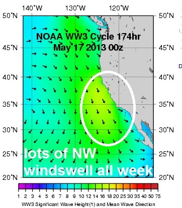
On a side note, our 1st storm of the year in the Eastern Pacific has been trudging along and didn't really get into a groove. Tropical Storm Alvin peaked yesterday with winds in the 50mph range, moved W away from us, and basically we won't see any surf from him. Especially with the good SW coming in a couple days that will override Alvin's tiny swell anyway. Regardless, glad to see the hurricane season kicking off.
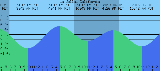
Tides the next few days are about 2' at sunrise, down to 0' mid-morning, up to 4' late afternoon, and down slightly to 3' at sunset. Water temps are finally feeling like spring with temps around 65.  Make sure to keep up to date on the waves/weather at Twitter/North County Surf. 

FORECAST:

Once Sunday kicks in with good weather and a fun NW/SW combo, the train keeps a rolling into Monday. There was a reinforcement storm in south America last week that will continue to send us good head high SW sets through the week- mostly pulses late Monday and again towards Friday.
 
 
The windswell is also forecasted to strengthen through week and get slightly bigger each day (peaking late week with shoulder high sets in far south county SD) and most spots around southern California will have overhead sets from the combo peaks. AND... the weather should be good in the beginning of the week too. All in all a good start to the work week then a little more May Gray the 2nd half of the week.

After that the north and south Pacific take a breather.

WEATHER:

Got another weak cold front coming through the state today which will thicken our low clouds and leave behind drizzle. May Gray at it's finest. Saturday is a transition day as it will be cool around here and hopefully some sun by late afternoon. High pressure kicks in Sunday and we have great weather through at least Tuesday and temps in the high 60's at the beaches. Yet another weak cold front is forecasted to roll through the state the 2nd half of next week and we'll be back to clouds and drizzle.

BEST BET:
3 days of fun SW swell, NW swell, and nice weather Sunday through Tuesday. Late next week looks like fun NW/SW too but the clouds/drizzle return. Plan accordingly.

NEWS OF THE WEEK:

NASA /JPL had a great story last fall about the possibility of hurricanes hitting southern California. Sure there’s been some shoddy records of tropical storms hitting us the past century but what about a full-fledged Florida style hurricane?! Here is NASA’s response the question everyone here wants answered…

There's an old adage that California has four seasons: earthquake, fire, flood and drought. While Californians happily cede the title of Hurricane Capital of America to U.S. East and Gulf coasters, every once in a while, Mother Nature sends a reminder to Southern Californians that they are not completely immune to the whims of tropical cyclones. Typically, this takes the form of rainfall from the remnants of a tropical cyclone in the eastern Pacific, as happened recently when the remnants of Hurricane John brought rain and thunderstorms to parts of Southern California. But could a hurricane ever make landfall in Southern California? The answer, as it turns out, is yes, and no. While there has never been a documented case of a hurricane making landfall in California, the Golden State has had its share of run-ins and close calls with tropical cyclones. In fact, California has been affected by at least a few tropical cyclones in every decade since 1900. Over that timeframe, three of those storms brought gale-force winds to California: an unnamed California tropical storm in 1939, Kathleen in 1976 and Nora in 1997. But the primary threat from California tropical cyclones isn't winds or storm surge. It's rainfall -- sometimes torrential -- which has led to flooding, damage and, occasionally, casualties. At NASA's Jet Propulsion Laboratory in Pasadena, Calif., JPL oceanographer and climatologist Bill Patzert was recently asked about the prospects for future tropical cyclones in Southern California.

QUESTION: Southern Californians don't generally think too much about hurricanes. But it seems as though every year or so, we get some rain from a tropical cyclone in Southern California. Which begs the question: could a hurricane ever strike here?
PATZERT: The interesting thing is that it really can't happen, statistically speaking. The odds are infinitesimal -- so small that everyone should just relax. Like 1 in 1,000. Of course, there's always a chance. As eastern Pacific hurricanes move northwest and weaken, what we have had are many instances where they dumped a lot of rainfall in Southern California. That's what happened with two monster storms in 1858 and 1939, both El Nino years. And there have been plenty of other examples. When Southern California does get affected by tropical systems, September is by far the most common month.

QUESTION: So why don't we get hurricanes here?
PATZERT: There are two main factors that work against hurricanes here: cool waters off the coast and the direction of the upper-level winds. Tropical cyclones draw their fuel, so to speak, from heat stored in the upper ocean. Typically, ocean surface waters greater than 80 degrees Fahrenheit are required to form and fuel these great storms. During the Northern Hemisphere summer and fall, the upper layers of the tropical oceans (down to approximately 330 feet depth) are steadily heated. By September, when hurricane season hits its peak, these waters reach their maximum temperatures, becoming, in a sense, high-octane fuel for hurricanes. But water temperatures never get that high in the coastal waters north of central Baja California. On rare occasions, they may reach about 75 degrees Fahrenheit near the shore in Southern California, typically during an El Nino episode. But generally speaking, low 60's is about as warm as they get farther from shore and elsewhere in coastal California. In the Pacific Ocean, the North Pacific Current flows from Japan eastward across the Pacific and then splits into the northern-flowing Alaska Current and the southern-flowing California Current. The cool-water California Current, which sweeps down the West Coast of the United States, really acts as hurricane repellant, protecting California and even Northern Baja California from hurricanes. The other factor at play here is the upper-level winds, which tend to carry and steer storms to the west and northwest, away from California, and also tend to shear the tops off of hurricanes, breaking them apart. Between the upper and lower-level winds, there's a lot of wind shear off the coast here in Southern California. These prevailing northwesterly winds also push warmer surface waters offshore, drawing cooler waters up to the surface, and this further adds to the cool nature of the nearby ocean waters that would weaken any storms that did approach California.

QUESTION: But is there a "Perfect Storm" scenario that would allow a tropical cyclone to have a major impact on Southern California?
PATZERT: The best odds for a tropical cyclone to affect Southern California are during a "Godzilla" El Nino event, when the waters off the coast are warmest, like we had in 1997-98 when waters were in the low to mid 70's. Or when we're in the positive phase of the Pacific Decadal Oscillation (PDO), a long-term pattern of change in the Pacific Ocean that alternates between cool and warm periods about every five to 20 years. We're currently in the early stages of a cool phase of the PDO, which tends to dampen the effects of El Ninos. Waters in the eastern Pacific generate more hurricanes during El Nino years. In addition, the upper-level winds would have to steer an unusually strong storm our way. That almost happened with Hurricane Linda in 1997, which briefly threatened Southern California before turning away to sea. But even if Linda had made landfall in California, it wouldn't have been a big wind event. It would have been more like an "atmospheric river" event, common in wintertime, with heavy rainfall and flooding. And storm surge, which is a big concern along the U.S. Gulf and East coasts, is really a negligible issue along most of the California coast, because much of it sits atop bluffs, above sea level.

QUESTION: Some scientists believe as Earth's climate gets warmer, the frequency and intensity of hurricanes may increase, though the jury is still out on that matter. Do you believe climate change will increase the odds of hurricanes affecting Southern California?
PATZERT: Nobody knows yet, and if anybody tells you they know the answer to that question, kick 'em out of your Rolodex file. In fact it's possible that there might be fewer hurricanes in a warming world. But the bottom line for Southern Californians is that even if global temperatures were to rise six degrees, a hurricane in California would rank very low on the list of things we'd need to worry about.

QUESTION. The winter of 1938-39 was something of a freak one for California, with multiple tropical cyclones and other storms affecting the state during the El Nino of 1938-39, resulting in major damage and a large number of fatalities. How have things changed in Southern California in terms of preparation for major storms since then?
PATZERT: Anytime you get too much rain too quick, it can cause damage and death, as we saw in the winter of 1938-39. But remember that was before we had a reliable observation network, based on ground and copious satellite measurements, which provided for useful forecasts and warnings. In addition, Southern Californians are flood resistant now because of those storms in 1938-39, which led to all the major rivers here being concreted. So we're largely immunized against these kinds of catastrophic flooding events now.

QUESTION. Do tropical cyclones have a significant impact on Southern California's annual rainfall?
PATZERT: In the Southeastern United States, an awful lot of the annual water budget comes from tropical storms, which can have a positive impact as drought busters. But tropical cyclones are not a significant contributor to our rainfall here in Southern California. The average rainfall in Los Angeles in September, even with rainfall from occasional tropical cyclones, is less than half an inch. These amounts are small compared to our normal winter total of 15.1 inches (31 centimeters). But we would certainly welcome any rainfall we can get in September and October, because it can help trump the effects of the hot, dry Santa Ana winds and their associated fire threat. And those are far more real threats to Californians than hurricanes will ever be.

BEST OF THE BLOG:

As the surf world gets ever so more crowded, creating new waves is a top priority. But the likelihood of wavepools, artificial reefs, or the availability of freeboarding/wakesurfing are few and far between. So what's the other alternative? How about bringing old waves back to life? That's the plan at one lagoon in north county San Diego. Check out the story on the blog as well as a mid-week Surf Check AND an in-depth THE Surf Report. All of that and more in the blog below!

PIC OF THE WEEK:

Considering the official start to hurricane season is May 15th AND we actually had tropical storm 'Alvin' form, I felt I should give some love to the kings of hurricanes- our East Coast brethren- with not 1 BUT two photos of the East Coast for the Pic of the Week. Of course it's once in a blue moon they actually get any surf out there but it doesn't mean I don't love them any less. As they say 'Only a face a mother could love'. Or is it 'Only a surfer knows the feeling'? Anyway, for more great shots of the east coast, head on over to ESM.

Keep Surfing,

Michael W. Glenn
Deputy
Making Friends Left and Right
Mr. June in the Reef Guy Calendar