Friday, August 29, 2014

THE Surf Report- Late Edition


Fantabulous.

SURF:

What can we say about Marie that hasn't been said already? Overhead surf here and 30' sets at the Wedge. Enough said. Marie maxed out last Sunday as a Category 5 beast with sustained winds of 160mph and was due SE of us at 160 degrees- just barely in northern OC's swell window.
As she started to die early in the week, she also turned more to the SSW, so north county SD saw good surf yesterday as the OC started to become more manageable. Marie has now dissipated roughly 500 miles SW of San Diego, but we'll still have leftover head high+ waves from her in SD and OC today. Saturday drops further with chest high waves.
As luck would have it, we had a small storm in the southern hemisphere last week too and that will deliver chest high SW swell on Sunday/Monday along with a waist high NW windswell. Water temps have rebounded nicely and are in the mid-70's around town.
Tides the next few days are 1' at sunrise, up to 5' mid-day, down to 1' at 6pm, and up slightly to 2' at sunset. Make sure to keep up to date on the waves/weather at Twitter/North County Surf.

FORECAST:
The SW/NW combo lasts into Monday for more chest high+ waves around town and then things slow down mid-week.
We have another storm on the charts today from the southern hemisphere that actually looks pretty good if it holds together. I'm hoping for head high+ SW next Thursday the 4th and that should last into the weekend. Basically the tropics are taking a breather and the southern hemisphere is stepping up to the plate. Make sure to check the blog below on Tuesday for the progress of the swells on the Surf Check!

WEATHER:

Great weather this week as high pressure has been in control. Looks like we have one more day today of clear skies and warm temperatures before the low clouds/fog return in the nights and mornings on Saturday. Low pressure is moving down the coast and we'll have cooler than normal temps next week. Nothing major but it will take a little longer for the sun to come out in the mornings and temps will be hovering around the high 60's/low 70's next week.

BEST BET:
Today with leftover Marie swell or Sunday/Monday with the small combo swell or next Thursday with the better SW swell. Basically every other day...

NEWS OF THE WEEK:

I talked about this a few years ago and I thought it was a good time to discuss it again now that hurricane Marie has rolled through. Swell angle. There. I said it. Cat's out of the bag. Why does it make a difference to beaches up and down the coast? Basically you can think of a swell like a rubber band. If you took a rubber band and put it a couple inches from the corner of a table, then stretched it around the corner, you'd notice the rubber band getting thinner. A swell moving up the coast will do the same thing- lose energy as it bends away to fit the coast. If a swell hits a beach straight on, you'll see the biggest surf. If it has to bend along the coast, it will lose energy. In the case of hurricane Marie, the peak of the swell was coming from a swell angle of around 160-180 degrees. Newport Beach is about 200 degrees- pretty close to the 180 swell angle.
So Newport felt the brunt of the swell. A place like Encinitas on the other hand faces about 260 degrees, so the 180 swell has to wrap all the way to 260 and loses energy. So while Newport had 15' sets, we were 1/2 that size down here. Same goes for the winter time- SD will pick up NW swells as a spot like Ocean Beach faces NW while here in north county SD will be smaller as we face SW.

PIC OF THE WEEK:

Just got a pair of Google Glass. Fell asleep on the couch last night and forgot to take them off. Inadvertently recorded this nightmare of mine. Going to take them back to Best Buy this weekend.

Keep Surfing,

Michael W. Glenn
Spectacular
National Team Captain
Was Given An Honorary World Title by the ASP

Tuesday, August 26, 2014

Surf Check

So this is it. Swell from Major Hurricane Marie is starting to show in southern California...

This morning we had dropping Tropical Storm Lowell swell for inconsistent shoulder high sets. Then Marie started to show in south facing LA and northern OC mid-morning. Currently they're getting sets up north around 10' with the Wedge seeing 15' sets. And building.
Marie peaked on Sunday with category 5 winds of 160mph and has since declined with 100mph winds today. And as soon as she peaked, she was SSE of us- which is too S for SD- so the OC will see the biggest sets tonight and tomorrow morning. Look for double overhead waves in HB and the odd 20' set at the Wedge. And as Marie came into the SD swell window yesterday, she was already dying. Doesn't mean we won't see solid surf from her. We should get sets a couple feet overhead in north SD by Wednesday afternoon. By Thursday we'll still have head high+ waves in the OC and north SD.
And as the tropics die off this week, the southern hemisphere comes alive. We had a storm flare up a couple days ago which should give us fun chest high+ SW late in the weekend.
We even have some NW windswell building on Sunday so we're on track to get fun combo swell for Labor Day. God bless America.
Further out, models show a good storm taking shape this later this week in the southern hemisphere which would give us shoulder high waves the middle of next week into the weekend.
So what's the weather look like as we head into the Labor Day weekend? First up, high pressure is building today and we'll have minimal low clouds/fogs in the night and mornings as well as beach temps in the mid-70's. Weak low pressure unfortunately moves down the coast over the weekend and the low clouds/fog will hug the coast a little longer than we'd like but we'll still have a shot of hazy sunshine in the afternoons with air temps around 70.
Water temps are still low 70's- which they should be for late August- and our tides the next few days are around 1' at sunrise, up to 5' before lunch, down to 1' again at 5pm, and up slightly to 3' at sunset. Make sure to get some waves tomorrow- but if you miss it- catch the new swell on Labor Day...


Thursday, August 21, 2014

THE Surf Report- Early Edition


Spoiler Alert!

SURF:
L-O-V-E love this time of year. Tropical weather, warm water, and hurricane surf. That's what I'm talkin' about! Sorry, a little fired up tonight. Let's start from the beginning.
Had fun combo surf last weekend then a slight lull mid-week and new tropical storm Lowell was filling in this afternoon. The Wedge actually had some 10'+ sets tonight. Lowell was an interesting storm. Models early in the week showed it being a weak tropical storm but it actually hit hurricane status earlier today. Lowell has since backed off but he was at least in our window for 3 days.
Look for Lowell to send us shoulder high sets tomorrow and bigger waves in the OC due to the S angle. Lowell will peak on Saturday with head high sets and more fun waves will be had on Sunday.
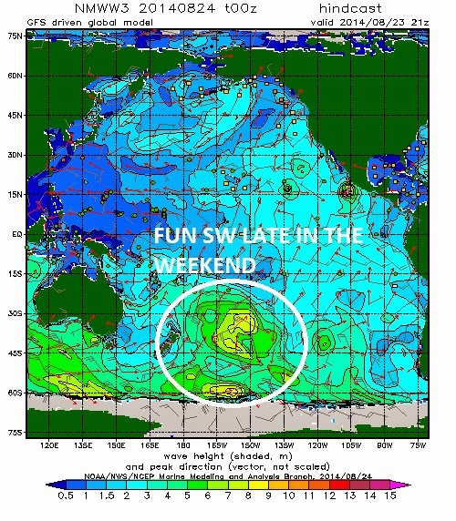
We also have some inconsistent chest high sets from the southern hemisphere but Lowell is the most important swell maker as far as I'm concerned this weekend.
Water is a pleasant 70 degrees and tides the next few days are 2' at sunrise, up to 4.5' mid-morning, down to 2' again at 2pm, and back up to 6' at sunset. Make sure to keep up to date on the waves/weather at Twitter/North County Surf.

FORECAST:
Alright. Let's get to the meat and potatoes of the report. First up, activity in the southern hemisphere. Weak. Not much headed our way except some background chest high set waves towards Thursday of next week. But that's going to get run over by Marie. Spoiler alert!...

So who's Marie? Only the greatest hurricane in like 100 years. Ok, not that long. And she hasn't even hit hurricane status yet, but models show Marie getting her act together at the beginning of next week and if all comes together, a major hurricane with winds around 120mph and headed N towards us. Since we haven't had big hurricane surf in a LOOOOOONG time, this is probably one to call in sick for. We should have Marie's S swell fill in fairly quickly on Thursday and last into at least Saturday with well overhead surf here and at least triple overhead surf at places like the Wedge. So there- I just jinxed it. Hope you're happy. Make sure to check out the blog to see the mid-week Surf Check on Marie's status and an in-depth THE Surf Report.

After Marie's supposed swell late next week, charts show the southern hemisphere putting together a little storm which may give us chest-shoulder high waves around the 5th of September. But until then, all eyes are on Marie to see what she'll do...

WEATHER:

Fantastic weather Wednesday morning. If you ever wondered what a Florida summer is like, now you know. Humid, lightening, thunder, downpours, and warm sun once it cleared out. The combination of an early season low pressure system (a sign of things to come from El Nino?) and some tropical moisture from Baja created the perfect conditions for mayhem around here. Surprised Governor Brown didn't call a state of emergency in north county San Diego. Everything has since calmed down and we have high pressure setting up shop this weekend and into next week for nice weather and temps in the mid-70's. Pretty comfortable for late August.

BEST BET:
Next Friday if Marie doesn't disappoint.

NEWS OF THE WEEK:
So what's the latest with El Nino? A lot of hype the past 6-9 months with the warm water temps this spring but things seemed to cool down in late July/early August. Luckily for us the hurricanes are starting to kick into gear and El Nino may be getting a second wind. The National Oceanic and Atmospheric Administration did a report last week on it's current status and future. Here's what they had to say:

July was a rough month for the potential development of El Niño. Waiting for El Niño is starting to feel like Waiting for Godot. NOAA's early August El Nino discussion showed trends were in the opposite direction, particularly with respect to the ocean. Below-average temperatures emerged at the surface in the eastern equatorial Pacific and were widespread below the surface. The appearance of seemingly unfavorable conditions has led to some comparisons with 2012, when an emerging El Niño instead collapsed. Are we in 2012 territory again? Is this El Niño again a bust? 

In 2012, sea surface temperatures were certainly above their normal average, but the atmosphere remained fickle.  In fact, certain atmospheric features across the tropical Pacific remained more suggestive of La Niña, the opposite condition of El Niño.  Namely, rainfall was above average near the Maritime Continent (north of Australia), which is a common feature associated with La Niña
In 2014, we have again struggled to see clear atmosphere-ocean coupling (i.e. interaction). For several months, the Niño-3.4 index (which tracks sea surface temperature anomalies in the east-central equatorial Pacific) increased, but then we saw that index lose ground in July. While the weakening is likely due to the lack of an atmospheric response, the atmosphere has not looked as La Niña-like as it did in 2012:  for example, the enhanced rainfall near the Maritime Continent in 2012 is absent in 2014. In other words, while the atmosphere isn’t yet acting like El Niño, at least it’s not acting like La Niña.

Also, this sort of summertime lull in warming in the east central equatorial Pacific is not unique when you look back at the more recent historical record. Several times in past years the Niño-3.4 temperature anomaly index lost ground for a time after an initial increase.  For example, the events starting in 1994 and 2006 had summertime lulls, but went on to become moderate-strength El Niño events (peak SST anomaly ≥ 1ºC).  It is interesting that these short-lived dips occurred in the June or July time period, which seems to imply that the Northern Hemisphere summer season might be a tough time for El Niño to develop if the event hasn’t already become more firmly rooted.

As reports have shown, this recent decrease was predicted 1-2 months ahead of time (with certain models showing hints at a warming plateau since early May 2014).  This advance notice strongly implies some models saw something in the climate system that accounts for the lull.

In contrast, during 2012, once the Niño-3.4 temperature index started to decrease, many models started to anticipate that El Niño was not going to occur. Currently we are waiting to see the latest runs from many of these models, but we can examine NWS/NCEP’s CFSv2, which is run every day. Clearly, the CFSv2, unlike in 2012, is not favoring a bust at this point. Though some members (thin lines) suggest that outcome, so it cannot be ruled out either.

In summary, we continue to favor the emergence of El Niño in the coming months, with the peak chance of emergence around 65% (i.e. there is a 35% chance of El Niño not occurring). ENSO forecasters do not expect a strong El Niño (we can’t eliminate the chance of one either), but we are not expecting El Niño to “fizzle.” In fact, just in the last week, we have started to see westerly wind anomalies pick up near the Date Line. Literally and figuratively, we may be witnessing the start of ENSO’s second wind.

PIC OF THE WEEK:

Tropical weather. Easy paddle out from the cove. No one out. Rippable right wall. Set out the back.

Not impressed.

Just kidding.

Keep Surfing,

Michael W. Glenn
Superhero
Perpetual 5th Year Senior
Been Called Mr. Y By Mr. X

Tuesday, August 19, 2014

Surf Check

Well that was fun while it lasted. Good SW late last week blended with fun NW windswell this past weekend (along with nice weather) and most everywhere had rippable waves.
Today unfortunately the SW has continued to drop and all we have are some windy chest high sets with a touch of waist high NW windswell.
At least the wind is blowing from the SW finally. 2 weeks of NW wind has knocked our water temps down from 75 to 67. Still nice once the sun comes out but I'm not a big fan of putting on any type of wetsuit in the middle of August. Tides the next few days will be about 3' at sunrise, up to 4' at 8am, down to 2' after lunch, and up to 5.5' at sunset.
 
 
So what's the latest with our weather? High pressure this past weekend that gave us nice weather (along with NW winds that cooled our water temps) has been replaced by an early season low pressure system filling in along southern California. As it does tomorrow, it will draw in tropical moisture which will give most areas a slight shot at thunderstorms. As the low departs east late Thursday, high pressure fills in once again and we have nice weather for the weekend and early next week.
 
Ok, enough of the pleasantries, let's get down to business. We had a storm last week off New Zealand which sent us some chest high SW swell. We should see it arrive later on Friday. It was blocked by Australia, Fiji, New Zealand, and Tahiti so expect some long intervals between sets.

But I don't care about that. What I care about is Tropical Storm Lowell. Out of the 12 named storms we've had this season, only Lowell has been directly aimed at us. Lowell is pretty feeble- winds are only forecasted to hit 65mph- but if you put it in perspective- we get chest high NW windswell here in SD County whenever the winds off Point Conception blow around 25 mph. So I'm expecting Lowell to give us head high surf towards Friday morning into Saturday. And the cool thing is that it will be short interval swell from the S. Something we hardly ever see here. Going to be some weird mysto spots going off this weekend.
But I don't care about that. On Lowell's heels is a storm forecasted to take shape by the name of Marie. If she gets her act together, we'll have a hurricane by this weekend, headed north to our swell window. Not to jinx it, but I'm hoping for overhead hurricane surf by the middle of next week- and maybe some significant summer rain if the clouds from Marie head our way too. Jinx!
 
And if you care what the southern hemisphere models have in store, there's just a little group of clouds on the charts for next week that may give us some small chest high SW towards the 1st of September. But until then, all eyes are on the tropics...


Thursday, August 14, 2014

THE Surf Report- Early Edition


56 days of summer down, 36 to go.

SURF:

Surf was pretty minimal all week unless you lived in the OC. We got a little bump in the SW today for chest high+ waves around town and head high sets towards the OC (again). Along with the pleasant water temps in the low 70's today, it was a fun day of surf once the low clouds burned off mid-morning.
As luck would have it, we had a good storm brewing last week in the southern hemisphere which will send more SW swell our way for the weekend. Look for the SW to peak on Saturday afternoon for shoulder high sets in north county SD and overhead sets in the OC. That will last into Sunday.
We also have Hurricane Karina out there but she's only a minimal hurricane and not forecasted to get stronger, she's moving away from us, and any small swell she may send our way will get overrun by the SW this weekend. Hey- at least she tried.
Tides the next few days are 1' just after sunrise, up to 5.5' at 2pm, and down to 1' again at sunset. Make sure to keep up to date on the waves/weather at Twitter/North County Surf.

FORECAST:
After a fun weekend of surf, the SW starts to back off during the beginning of the week and the 2nd half of next week looks small.
Models though show some more storms building under Oz/New Zealand this weekend but they'll get torn apart by the south Pacific islands. We should though get some fun inconsistent surf late next weekend.

WEATHER:

Still haven't had a full blown heat wave this summer (that was back in the spring month of May if you'll remember) and this weekend we'll have great weather again- but no barn burner. High pressure is building slightly tonight which will shrink our low clouds/fog during the nights/mornings and we're left with great beach weather this weekend and temps in the mid-70's. Weak low pressure is forecasted to move through northern CA late Sunday and it will thicken up our low clouds/fog in the nights/mornings early next week. After that things get fuzzy as some models show the mild weather continuing OR we get a slight return of monsoon moisture towards the end of the week. All in all some nice weather this weekend and early next week with no major problems on the horizon.

BEST BET:
Saturday. Good weather and a good SW swell. Fire up the hype machine!

NEWS OF THE WEEK:

Locals and tourists alike have known for years that a dirty beach is a downer for everyone. The National Oceanic and Atmospheric Administration just did an economic study to prove that marine debris along our shores costs California residents millions of dollars. And if the recession wasn't bad enough!

Southern California residents lose millions of dollars each year avoiding littered, local beaches in favor of choosing cleaner beaches that are farther away and may cost more to reach, according to a new NOAA-funded Marine Debris Program economics study. Reducing marine debris even by 25 percent at beaches in and near California’s Orange County could save residents roughly $32 million during three months in the summer by not having to travel longer distances to other beaches. The study, led by Cambridge, Massachusetts-based Industrial Economics Inc., known as IEc, is the first of its kind to look at how marine debris influences decisions to go to the beach and what it may cost. The study showed that having no marine debris on the beach and good water quality were the two most important factors in deciding which beach to go to. Given the enormous popularity of beach recreation throughout the United States, the magnitude of recreational economic losses associated with marine debris has the potential to be substantial. In July and August 2013, IEc assessed 31 popular Southern California public beaches from San Onofre Beach to Zuma Beach, collecting data on beach characteristics, including amenities such as bathrooms and parking, the amount of marine debris, and whether or not the beach was regularly cleaned. The researchers found that the amount and type of marine debris varied from beach to beach, although the majority of the debris was plastic. NOAA and IEc also surveyed Orange County residents on their recreation habits, including how many day trips they took to the beach from June - August 2013, where they went, how much it cost them, and which beach characteristics are important to them. “This study shows that beachgoers are worried about marine debris and will seek out cleaner beaches for recreation at a cost,” said Nancy Wallace, NOAA Marine Debris Program director. “Reducing or eliminating marine debris from our beaches is critical, because littered shorelines are costing people more than we anticipated. We can use these kinds of data to prioritize beaches for debris prevention and removal activities.”

IEc used a common travel cost model that estimates the value of beach recreation to the public and how marine debris may influence that value. Some of the travel costs considered include gas money, parking fees, and value of time spent traveling to and from the beach. Using the public survey information combined with collected beach data, IEc estimated how much Orange County residents would potentially benefit, including how often they visit beaches and how much they would save in travel costs, over a summer season by reducing marine debris at some or all of the 31 beaches. For example:

•Implementing an urban litter program that reduces marine debris by 75 percent from the beaches near the outflow of the Los Angeles River would benefit users of those beaches $5 per trip and increase visitation by 43 percent.

•Reducing marine debris by 100 percent at all 31 beaches would save $65 per person, or $148 million for all 2.28 million Orange County adults.

•Reducing marine debris by 25 percent at all 31 beaches would save $14 per person, or $32 million for all 2.28 million Orange County adults.

•Eliminating all marine debris from the five beaches with the highest levels would save $28 per person, or $63 million for all 2.28 million Orange County adults.

The study is focused on Orange County because of the number and variety of beaches, their importance to permanent residents, ease of access, and likelihood that marine debris would be present. Researchers believe that, given the results, the study could be modified for assessing similar coastal communities in the United States.

BEST OF THE BLOG:

Not to name drop or anything (but I will), I've hung with a few famous people in my life. From Aerosmith to John Wooden, from Leslie Mann to Chris Isaak, and Tom Curren to Magic Johnson, I've rubbed elbows with the best of them. But arguably the most important person I've come across is Don Hein. Never heard of him? He only makes the greatest food on earth. Check out the blog to see what I mean. As well as a mid-week Surf Check and an in-depth The Surf Report; all of that and more in the blog below!

PIC OF THE WEEK:

After seeing 200+ guys out at Swami's on a solid winter swell or Ponto looking like a Lower's crowd on a Saturday in July, it still amazes me when I see pics like this and realize there are empty waves out there. Unfortunately they're 1/2 way around the world and tigers roam the beach, but still, they're out there! Someone though will be lucky enough to stumble upon this wave tomorrow and get a couple cracks at it. All by themselves. And the tigers of course.

Keep Surfing,

Michael W. Glenn
Staggering
Mikey From Life Cereal
Taught Crammy How To Cutback