Thursday, April 29, 2021

THE Surf Report


The EBS is in for repairs.

SURF:


Well wasn't that a dud. Actually, let me rephrase that- Congratulations Orange County! The supposed solid swell that was to light up the OC and send us a smaller version last weekend really did light up Camp Pendleton and sports north. And down here? Not really. Even though the storm looked promising on the charts, it had too much of a southerly angle unfortunately and passed right by us. And to add insult to injury- the clouds never cleared in SD! So what's a surf forecaster to do? Try again I guess. So here goes:


We've got a new small SSW swell building Friday for waist high surf with chest high sets towards the OC. On its heels is a small bump in NW windswell on Saturday. Most everywhere should see chest high sets from the combination of swells. 


On Sunday... we have a new S swell filling in again (better towards the OC of course) as well as a late season chest high+ NW groundswell from the Aleutians. The S will be better towards the OC and the NW in SD... so what about us stuck here in the middle of north county SD?! Hopefully we'll see shoulder high sets from the combo. We deserve it after last weekend's debacle. One item of note- we may have a weak cold front move by the N this weekend so winds may be an issue out of the SSW- most likely strongest by Sunday. So we've got surf- but wind also possibly. And here's the tides, sun, and water temps for the next few days:
  • Sunrise and sunset:
    • 6:01 AM sunrise 
    • 7:31 PM sunset
    • 13.5 hours of sunlight!
  • Water temps have been FRIGID lately due to the clouds earlier in the week and NW windswell. Most spots were 58! But with the sun this weekend, we should be back to the low 60's.
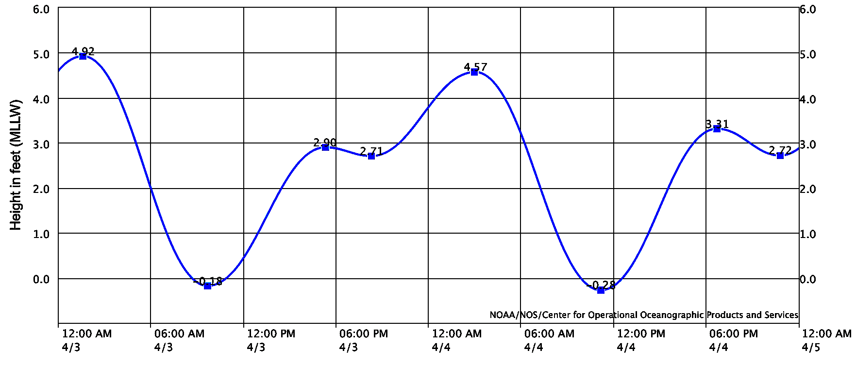
  • And the tides this weekend are a little odd:
    • -0.5' at sunrise
    • and pretty much 3' by mid-afternoon...
FORECAST:

The shoulder high NW/SW from Sunday continues on Monday and we may have cleaner conditions too.


Most of next week looks to be waist high+ from the NW/SW then models show more NW windswell towards Saturday for chest high sets. 


By Sunday, we should see more consistent chest high surf from a new SW. 


And farther out... forecast charts show a good south taking shape in the next few days which would put a shoulder high sets from the SW at our beaches around the 13th. Just need those S winds to stay away! 

WEATHER:


Nice to see a couple showers early in the week. We only had 1/10" at the beach but the foothills got 1/4" and even a dusting of snow at the highest peaks. That's gone of course and our great weather today will roll into Friday with more sunny skies and temps in the high 70's. A weak cold front starts to roll to the N on Saturday and our temps drop to the high 60's along with more low clouds/fog down here. By Sunday, the low pressure kicks up our winds to the 10-15 mph range from the SW and temps hit the mid 60's- 15 degrees colder than Friday! Slight high pressure builds early next week for temps again back in the low 70's and less low clouds/fog. If anything changes between now and then, make sure to check out North County Surf on Twitter here!

BEST BET:

Tough call as this weekend will have waves but winds could be an issue. Or wait until next weekend with more SW and cleaner conditions? Or a bigger SW towards the 13th?! Only way to find out- surf them all!

NEWS OF THE WEEK:


Heard the saying 'Only a surfer knows the feeling'? How about 'Only a surfer sees pelicans surf'? You know what I'm talking about: Pelicans seemingly doing a floater above the lip of a wave and gliding forever. How do they travel so far with out flapping their wings? Seems as though they're good at doing airs (or riding air) as well as flying. Here's the San Diego Union Tribune to elaborate:

Take a walk along the beach in San Diego County and you’re likely to end up marveling at the majesty of birdlife. Sleek brown pelicans descend from the sky and glide — often hundreds of yards at a time — just above the ocean’s surface, in front of building waves. It’s a common phenomenon that was not deeply understood — until now. UC San Diego has come up with the most detailed theoretical model yet for describing and quantifying how pelicans harness the ocean and winds with little or no need to flap their wings.

The bottom line: pelicans — which have wingspans up to 7.5 feet wide — are fantastically skilled at gliding atop the updraft of wind that is created by moving waves. The waves get steeper as they near shore, further strengthening the updraft. The bigger the wave, the bigger the lift. And pelicans know it; they get as close as possible to the ocean’s surface, where the updraft is strongest. It’s not unusual for a 6-foot wave to produce a 30-foot-tall updraft. The birds typically glide until the wave breaks, then soar back into the sky, only to quickly drop back down to repeat a process that isn’t very taxing on them physically.

“They’re using the environment to make their lives easier; it’s like riding a bike downhill,” said Ian Stokes, a doctoral student at UCSD’s Scripps Institution of Oceanography. Stokes is the lead author of the new model, which was recently published in the journal Movement Ecology, with lots of guidance from his adviser, Scripps oceanographer Drew Lucas. The model is basically a set of mathematical equations that enable scientists to determine how much energy pelicans can save by gliding on the updrafts. In some cases, the birds save comparatively little energy. In other cases, they don’t have to flap their wings at all. The model factors in everything from the height and periodicity of waves to how close pelicans fly to the ocean’s surface. Stokes began developing the model at UC Santa Barbara, where he earned a bachelor’s degree in physics. To his surprise, Lucas encouraged him to develop the idea further when he arrived in La Jolla.


“I thought it was a silly little thing — not a significant problem,” Stokes said. “I thought we needed to focus on climate change.” In a very real sense, that’s what he’s been doing. “This work is teaching us about how the atmosphere and the oceans interact,” Lucas said. “And how they exchange energy. That’s what’s involved in climate change. We’re learning important things about ocean and atmospheric physics.”

The new model also could help biologists and ornithologists who are more broadly studying the metabolic cost of flight among birds. Stokes’s new study involves one of the most beloved birds known to exist. Pelicans can ascend 60 to 70 feet into the air, where they’re able to easily see the fish they prey on. And they can fly up to 30 mph, often in handsome V-shaped formations.

“I love the fact that they are a mix of elegance and awkwardness,” said Nigella Hillgarth, a nature and wildlife photographer who formerly served as director of UCSD’s Birch Aquarium. “They can look awkward when moving about on land, and sometimes when they’re fishing. But they’re incredibly graceful when they’re gliding through the air. I often gaze at the pelicans until they fly so far I can barely see them any more as they skim over the water.
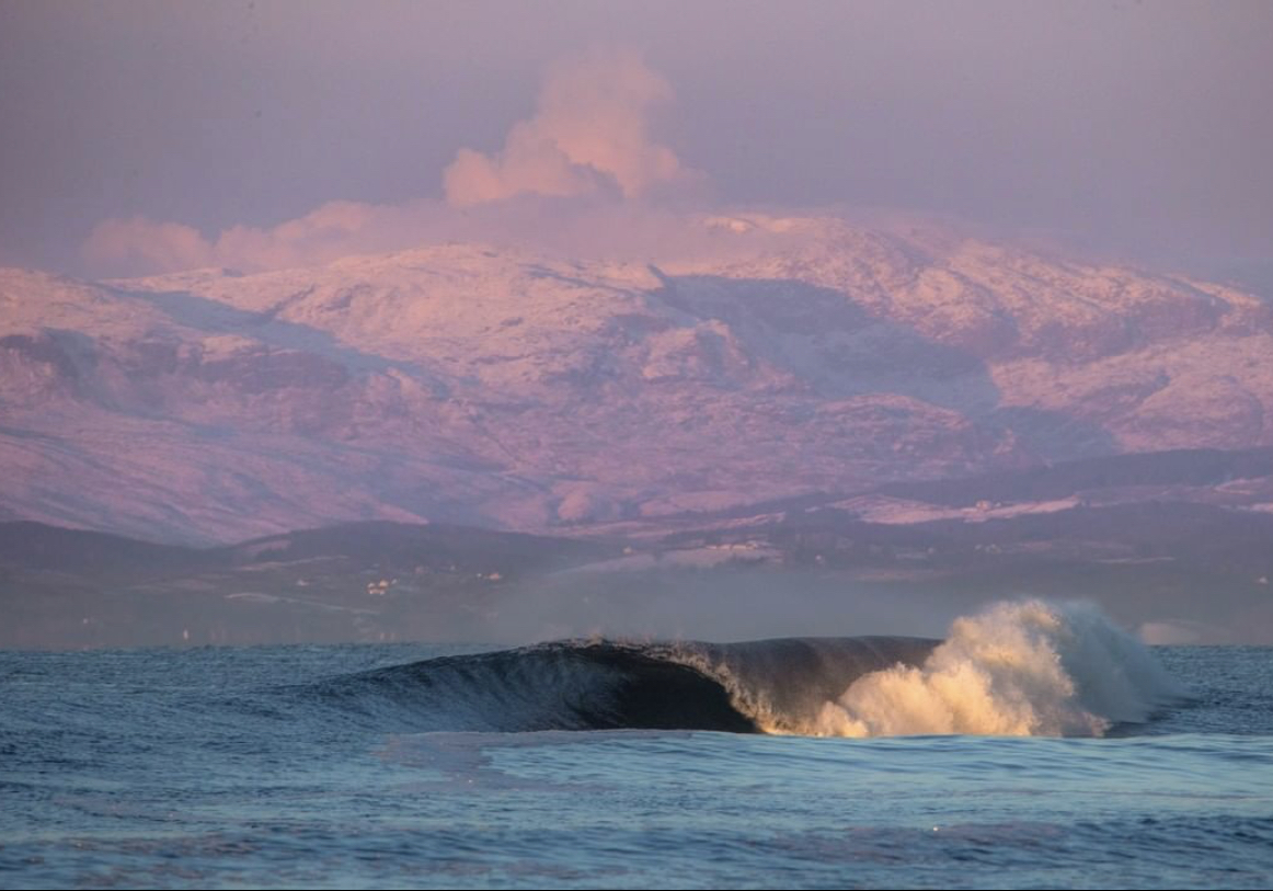
PIC OF THE WEEK:


Had a buddy recently pack up and move to Central America. Was it the cheaper cost of living down there? The laid back lifestyle? The natural beauty? How about the warm air and ocean? Anything else I missed?...

Keep Surfing, 
Michael W. Glenn
Everything To Everyone
NFL's Mr. Irrelevant 2021
So Many Waves, So Little Time (TM)

Thursday, April 22, 2021

THE Surf Report


Here we go...

SURF:
Fun surf last weekend was replaced by April shizzle (showers + drizzle) mid-week and blew out any type of fun surf we could have had. 


The weak low pressure the last few days will hang around Friday but with less wind fortunately and we've got building SSW with a touch of NW the next few days for GOOD surf. The Emergency Boardriding System has been activated (as well as the crowds). A solid storm last week of Antarctica has sent a couple pulses of SSW swell our way and is filling in today. For Friday, look for shoulder high sets in the afternoon and head high sets towards the OC. On Saturday and Sunday, the SSW will be in full swing (with a touch of NW windswell) and we'll see head high+ surf. Most everywhere will have waves so spread out people! And here's the tides, sun, and water temps for the next few days:
  • Sunrise and sunset:
    • 6:09 AM sunrise (up by 5:30!)
    • 7:25 PM sunset (home by 8!)
  • Water temps have cooled slightly to the low 60's. Even though we've had S wind which should be pooling up the water in the CA bight, the clouds have had a negative effect...
  • And the tides this weekend are back to normal:
    • 4' at sunrise
    • 5' at 8 AM
    • just below 0' after 2 PM
    • and back up to 5' at sunset
FORECAST:
We have lingering shoulder high surf on Monday BUT... it looks like there's one last gasp from our N Pacific storm machine and we'll get showers and breezy conditions on Monday- just enough to screw up the surf. 


Tuesday is a transition day and Wednesday we see new SW in the chest high range. 


Charts show another storm taking shape above Hawaii next week and hopefully we'll get chest high WNW from it next weekend- and no rain? 


We also have a better SSW taking shape which would arrive late next week and last through the weekend with more shoulder high surf. Looking fun the next 7 days (expect for those late season cold fronts)!

WEATHER:


Just when I thought we were on track for sunny skies from here on out, Mother Nature on Earth Day of all days, throws a monkey wrench into my plans. As mentioned above, we have one last cool day on Friday before sunny skies prevail on Saturday with temps in the high 60's. Sunday starts off nice then the breeze/clouds kick in late in the day and we're back to showers on Monday and possibly Tuesday. The 2nd half of next week looks to be sunny and slightly warmer- finally. If anything changes between now and then, make sure to check out North County Surf on Twitter!

BEST BET:
Friday to Sunday with good SSW and a touch of NW. Or mid-week with new SW and better SSW/NW next weekend! Pray the shizzle is gone by then! 

NEWS OF THE WEEK:


In honor of Earth Day, here's 10 weird facts to remind you why this big blue marble is awesome (compliments of Popular Mechanics):
  1. Earth's Core Is as Hot as the Sun's Surface: "Within uncertainty, the temperature at the center of the Earth is the same as the temperature at the surface of the sun (5800 K)," Caltech geochemist Paul Asimow tells Popular Mechanics. At about almost 10,000 degrees Fahrenheit, that's hot.
  2. Earth Is Radioactive: In total, Earth generates as much as 40 terawatts of heat, half of which comes from radioactive decay in its core, according to a 2011 study. Scientists measured particles called antineutrinos that streamed up from Earth's core and found that half of Earth's heat is generated through the radioactive decay of certain elements. Tom Crafford, a Mineral Resources Program Coordinator at the U.S. Geological Survey tells Popular Mechanics: “Most of the internal heat that keeps Earth a living, vibrant planet comes from the radioactive breakdown of elements like thorium, uranium and potassium."
  3. Life Below the Seafloor: "The sediments underlying Earth's oceans are home to approximately 2.9 x 10^29 microorganisms, existing at depths as great as 2.5 km below the seafloor. The majority of this deep subseafloor biosphere grows extremely slowly relative to life in the surface world, with estimates of cell division once every 10-1000+ years." Caltech's geobiologist Victoria Orphan tells Popular Mechanics. Scientists are finding new sources of microbial life deeper and deeper below the seafloor than ever before. In March, a team of scientists revealed that they had found traces of bacteria (try 10 billion bacterial cells) in rocks 400 feet below the seafloor—deeper than ever before.
  4. Days Are Getting Longer: "The tides are the small differences between the gravitational pull of the Moon and the Sun and the centrifugal forces in the opposite directions. The tides on Earth are strongest when the three bodies are in a line, which happens near full Moon and new Moon. Then the Earth is being stretched out along that line," says Ingersoll. "The ocean responds the most, but even the solid Earth responds to the tidal forces," he says. "The response consists of water moving in the oceans and rocks moving underground, both of which dissipate kinetic energy. The net result is that the Earth is spinning down—the day is getting longer."
  5. Earthquake Weather Is a Myth: "Each culture has a its own version of 'earthquake weather' to rationalize when and where a earthquake will hit," seismologist Dr. Lucy Jones of Caltech tells Popular Mechanics. "Earthquakes are below the surface and need a constant fault to happen and this has nothing to do with weather."
  6. Seas Could Rise 2.5 Feet By 2100: "We are headed toward a two-foot sea level rise by the end of this century," climate scientist Tapio Schneider of Caltech tells Popular Mechanics. "Consequences from a one to two-foot sea level rise could mean severe threats to low-lying island nations, loss of narrow, shallow beaches, and a demise of marine ecosystems."
  7. Clouds Help Regulate Earth's Temperature: "If you bring all water droplets in clouds to the surface, you would cover Earth with a liquid film no thicker than a human hair," Schneider of Caltech tells Popular Mechanics. "And yet, this tiny amount of water makes the difference between cool overcast summer days and warm clear days. And it is immensely important for climate. On average, clouds cool Earth by 13 F relative to what global temperatures would be without clouds." "How much global warming we get crucially depends on whether we get more or fewer clouds as the climate warms," Schneider says. "Climate models do not agree on the answer, because simulating clouds and the tiny amount of water in them is hard. At Caltech, we are working on using AI to make climate models and their cloud simulations better, to get more precise answers about how climate will change."
  8. We Don't Know Who "Named" the Earth: Unlike other planets, no real historical data can be found on the person (or group) that named our planet "Earth." The term Earth comes from Old English and High Germanic and is the only planet not named after a Greek or Roman god.
  9. Route 66 Is Longer Than the Distance to the Earth's Core: "The boundary between Earth’s mantle and core is roughly 3000 km below our feet—a little less than the total length of America’s ‘Mother Road’, Route 66.," seismologist Jennifer Jackson of Caltech tells Popular Mechanics. "Thought to be a simple interface between solid rocks and liquid iron-rich metal, this remote region is almost as complex as Earth’s surface." "Impossible to reach in person, geophysical and experimental studies of this distant region reveal a fascinating landscape of chemical and structural complexity that influence what's happening on Earth’s surface," Jackson says. "For example, the complex dynamics of Earth’s core-mantle boundary affects Earth’s protective geomagnetic field and the motion of tectonic plates."
  10. A Magnitude 12 Earthquake Would Split the Earth in Half: "We’ve never seen anything larger than 9.5 and it was longer than the state of California," says Jones. "It would be theoretically impossible to have a magnitude 13 earthquake since it would require a fault bigger than the Earth."
PIC OF THE WEEK:


Lake Michigan going off! (Or at least that's what the guy said who sold me the photo).  

Keep Surfing, 
Michael W. Glenn
In The Zone
Atari 2600 Gamer
Did A PSA For The ASP About the PSAA

Thursday, April 15, 2021

THE Surf Report


SURF:
Not much going on earlier this week as we had overcast conditions, drizzle, and SW winds. Welcome to spring. Things are looking up though and I'm going to activate the Emergency Boardriding System. Why? The weather is going to be great, we have SW swells in our future, and the water is warming up! That's a recipe for a good session. Just plan accordingly as the crowds will be thick! 


For Friday, we'll have chest high surf with shoulder high sets from the SW and head high waves towards the OC. That holds through the weekend with a slight bump in the NW windswell Sunday- and the beaches may hit 80 by then too. And here's the tides, sun, and water temps for the next few days:
  • Sunrise and sunset:
    • 6:16 AM sunrise (definitely paddle out by 6 AM)
    • 7:20 PM sunset (definitely stay out until 7:45 PM)
  • Water temps are between 63-65 and may hold at 65 by Sunday once that sun comes out. 
  • And the tides this weekend are interesting:
    • 1' at sunrise
    • 0.5' mid-morning
    • and 3' at sunset
FORECAST:
Monday has leftover NW/SW for chest high+ surf then things get funky Tuesday/Wednesday as a weak cold front comes through yet again. That will mess up any kind of small but fun surf we have on tap. 


No problem though as good SW swell arrives mid-week and once the weather cleans up the 2nd half of next week, we've got head high surf from the SW and great weather again. That lasts through next weekend. And on that note, I'll flip on the Emergency Boardriding System yet again. 

WEATHER:


Looks like we're in for some great weather this weekend. High pressure behind our departing low pressure today will set up sunny skies tomorrow and temps near 80 at the beaches by Sunday. Monday is a transition day as another low pressure system moves by to our N and kicks up our drizzle down here by Tuesday. That lasts into Wednesday. Thursday should be nice then we start the whole process over again next weekend with sunny skies and great weather. If anything changes between now and then, make sure to check out North County Surf on Twitter!

BEST BET:
This weekend with fun waves from the SW and sunny skies. Or late next week with a bigger SW swell and great conditions yet again. I love surfing. 

NEWS OF THE WEEK:


The Climate Prediction Center (CPC) released their latest three monthly outlook recently. La Niña is expected to fade into neutral conditions this spring (good news for us). But what about our dry winter- what does that mean for drought potential? Here are the outlooks for May, June and July...


The three month precipitation outlook looks to be average for Southern California and much of the Southwest (more good news but it won't help with the deficit unfortunately). Below normal precipitation is most likely for the rest of the West, while the East is favored with wetter odds.

The Seasonal Drought Outlook for mid-March through June calls for drought development for far southwest California and the central coast, joining the rest of the state and most of the West in drought conditions (not good for fire season this fall).


The three month temperature outlook is simple. Hotter than normal conditions are most likely for the entire country except the far Pacific Northwest. Most pronounced odds for a hotter May-June-July period are found in the Southwest (Less fog? A good thing)? 

Hope you like a dry, hot, summer...

PIC OF THE WEEK:


As our water temps warm up, cold water surfing is becoming a distant memory this spring. Ps- water temp in Alaska today was 38 in case you were wondering. 

Keep Surfing, 
Michael W. Glenn
Untapped Potential
Excited To Host The Oscars This Year
Bought A Fleet Of Jet Skis & Founded 'Uber For Surfers' Because Paddling Is So 2020

Thursday, April 8, 2021

THE Surf Report


Goodbye NW, hello SW!

SURF:
As is expected this time of year, the NW swells back off and the SW swells start to build (as well as the rain leaving and the fog returning). 


Fun week of surf, even if it wasn't big. This weekend we're in the middle of Groundhog Day with leftover SW swell and a touch of NW windswell for waist high surf and chest high sets. On the bright side, water temps are consistently over 60 degrees (jinx!), with most spots in SD and the OC showing 61-63. And here's the tides, sun, and water temps for the upcoming weekend: 
  • Sunrise and sunset:
    • 6:25 AM sunrise 
    • 7:15 PM sunset 
    • Seems like eons ago when the sun set at 4:45 around here
  • Water temps are 63 in SD (and 52 in SF, 75 in HI, 85 in Guam, and 39 in Alaska if anyone is interested)
  • And the tides this weekend aren't much:
    • 2.5' at sunrise
    • 4.5' mid-morning
    • 0.5' mid-afternoon
    • and 3' at sunset
FORECAST:
Got a couple fun SW swells lined up for the next 2 weeks. 


Monday starts off slow then we get a small bump in the SW on Tuesday for more waist to chest high surf. That fills in further and peaks on Thursday for shoulder high surf and bigger sets towards the OC. One minor problem though- we could see a weak cold front moving through on Tuesday for a chance of DRIZZLE (crazy) and bumpy conditions of course. Should clean up by Wednesday though. 


Once that swell winds down late in the weekend, charts show a chest high SW arriving again towards the 19th which will linger into the 21st. Fun waves all around, water temps inching up slightly, and no major storms in sight. Spring has sprung. 

WEATHER:


Average spring weather the past week as you've probably noticed with night/morning low clouds/fog and temps at the beaches around 70. That sticks around this weekend then we see a weak cold front move through on Tuesday for drizzle, SW winds, and overcast skies. Wednesday will be a transition day and then we're back to... low clouds/fog in the nights/morning and temps near 70. If anything changes between now and then, make sure to follow North County Surf on Twitter!

BEST BET:
Friday with leftover small combo swell, or Wednesday/Thursday with new SW and hopefully clean conditions, or clean conditions around the 19th and more SW again. 

NEWS OF THE WEEK:


You've heard of weather forecasts of course. And since you're a surfer, you've heard of surf forecasts (like yours truly). But have you heard of rip tide forecasts? Probably not. But it's a thing. And it's new thanks to the National Oceanic and Atmospheric Administration (NOAA). Here's how it works:

For the first time, NOAA is launching a national rip current forecast model, aimed at saving lives of beach-goers around the country. This new model can predict the hourly probability of rip currents along U.S. beaches up to six days out.

NOAA’s National Ocean Service and National Weather Service collaboratively developed and implemented the model, which leverages wave and water level information from the recently upgraded National Weather Service’s Nearshore Wave Prediction System. Similar to predicting weather or precipitation, the model predicts the likelihood of dangerous seaward currents on a sliding scale - from 0 to 100%.

“Safety for beach-goers and boaters is taking a major leap forward with the launch of this new NOAA model,” said Nicole LeBoeuf, acting director of NOAA’s National Ocean Service. “Extending forecasting capabilities for dangerous rip currents out to six days provides forecasters and local authorities greater time to inform residents about the presence of this deadly beach hazard, thereby saving lives and protecting communities.”


“Improved model resolution will enable forecasters to issue more accurate and detailed rip current forecasts further into the future,” said Allison Allen, Chief, Marine, Tropical, and Tsunami Services Branch, NOAA’s National Weather Service. “This information enables public safety personnel to better prepare for hazardous beach conditions and inform the public of potential for danger before they head to the beach.”

The forecast model covers a majority of the U.S. East and Gulf Coast and portions of California, Hawaii, Guam and Puerto Rico. Additional coastline coverage will be expanded in the future.

“Rip currents account for an estimated 100 deaths in the United States each year,” said Gregory Dusek, NOAA scientist who developed the model. “Before this, forecasters were manually predicting rip currents on a large section of the ocean twice a day and only a day or two into the future. The earlier prediction has potential to substantially increase awareness and reduce drownings.”

Further improvements are on the horizon and the application of webcam imagery and artificial intelligence identification of rip currents is showing promise across the research community. Partners in this work include the Southeast Coastal Ocean Observing Regional Association (SECOORA), the United States Geological Survey (USGS), the United States Lifesaving Association (USLA) and academia. 

As a surfer, it was only the waves and weather we had to account for to make sure we had the best session possible. Now throw in rip tide predictions to the mix. The only thing missing is a crowd forecast! Make sure to click HERE to use the rip tide forecast!

PIC OF THE WEEK:


This picture literally looks like a long lost photo you find on the wall in some dive bar in Western Oz. And if you ask the one eyed bartender where it is, he'd say 'It's gonna cost ya...'

Keep Surfing, 
Michael W. Glenn
Unperturbed
Guiness Record Holder World's Longest Toe Nails
Spoiler Alert: I Win Kelly Slater's Ultimate Surfer Coming This Summer To ABC!

Thursday, April 1, 2021

THE Surf Report


SURF:


Now that was one heck of a fun week. Weather was phenomenal, surf was darn fun, and the water started to warm up (slightly). Hope you got some. For tomorrow and Saturday, we've got a continuation of the SW swell in the chest high range (better towards the OC) and the weather changes SLIGHTLY. Nothing to be alarmed at- just a return of the low clouds/fog in the nights/mornings. And air temps a manageable 70. No complaints. 


For Sunday, we have a new SW fill in for more shoulder high surf (better towards the OC again) so it should be fun this weekend. And here's the tides, sun, and water temps: 
  • Sunrise and sunset:
    • 6:34 AM sunrise (paddle out at 6 AM?)
    • 7:10 PM sunset (paddle in at 7:30 PM)? 
  • Due to the heat wave, water temps are 60-62! BUT... will probably get back to the high 50's next week (more on that in the WEATHER section below)
  • And the tides this weekend are minor:
    • 2' at sunrise
    • -0.1' mid-morning
    • 3' at sunset
FORECAST:

We get to a more spring like pattern next week with weak troughs moving by to the N of us, more night/morning low clouds/fog, a little more of a sea breeze, and cooler air temps. That's the bad news. Good news? More surf coming! The SW that filled in on Sunday peaks on Monday for shoulder high sets in SD and head high+ at best OC spots. 


Also, due to the cold fronts up N next week, they'll be sending us more NW windswell starting late Monday into Tuesday. That should make the SW swell peaky for most spots. 


After that, the SW/NW backs off the 2nd half of next week but we have more chest high NW windswell filling in next weekend. 


Further out, models show storms off Antarctica coming to life and we should see more shoulder high SW around mid-month. No complaints! 

WEATHER:


Pretty epic week with warm temps, minimal winds, and a few tropical clouds floating overhead. Always interesting those storms that come down from the Aleutians this time of year but don't move inland through CA- but rather parallel to our coast. As they do, they pick up tropical moisture and we get 'Xmas in July'- or rather tropical looking clouds in April that we normally don't see until August. Things get back to normal this weekend though- and most of next week- with night/morning low clouds/fog, and temps around 70 once the sun comes out mid-day. And with the return of cooler temps and the NW sea breeze- expect our water temps to drop a couple degrees. If anything changes between now and then, make sure to click on the button below and follow North County Surf on Twitter!

BEST BET:

Monday/Tuesday with combo swell. Or mid-month with more fun SW swell. I love Spring Break!

NEWS OF THE WEEK:


Can we all agree we're not going to see anymore significant rain this season (which runs October 1st to September 30th by the way). On average, if we're lucky, we'll see 3/4" of rain in April. But considering it's a La Nina year, we'll be lucky to see 1/4". So let's call it like it is: We're done. So where did we end up in this drier than normal rainy season?...
  • Newport Beach: 4.39" so far (should be at 11.87"). That's just 37% of normal. And we're hoping to see 13.3" by the end of summer!
  • Oceanside: 5.32" so far (should be at 11.85"). That's just 45% of normal! And we're hoping to see 13.66" by the end of summer!
  • San Diego: 4.36" so far (should be at 9.21"). That's just 47% of normal! And we're hoping to see 10.34" by the end of summer! 
Luckily for us, last winter we were around 100% of normal for most Southern CA locations. So we should be able to survive this summer with enough water in our reservoirs (don't go hosing down your driveway though). And the forecast next winter? Maybe a slight La Nina or average at best. Maybe it's time to let those lawns go brown again. 

PIC OF THE WEEK:


J-bay comes to Portugal. Wonder when Jeffreys will visit us?

Keep Surfing, 
Michael W. Glenn
Canny
How A Pirate Looks At 50
As A Kid I Believed Albert Kekai Or Wayne Bartholomew Was The Easter Bunny