Wednesday, November 25, 2015

THE Surf Report- Early Early Edition


Every weekend should be a 4 day weekend.

SURF:
Don't think I've ever done THE Surf Report this early in the week before. I had to though- I plan on eating a mountain of turkey tomorrow and passing out in front of the TV as Romo battles Cam. But enough of my plans for the holiday weekend, what's yours? Surfing high on your list? Good, we've got some waves the next couple days- and weather too.
Today we saw some short interval NW windswell from a low pressure system overhead. Sets were head high in the AM and chest high by sundown. Tomorrow we have more of the same chest high NW windswell as conditions stay breezy. That lasts into Friday. As the junky conditions exit the region by Saturday, the NW windswell goes with it too.
Of special note: The hurricane season comes to a close November 30th and is going out with a bang. Hurricane Sandra, currently located S of Cabo, is the strongest hurricane so late in the season in the Eastern Pacific. It is a category 3 (i.e. a major hurricane with winds of 120 mph+, which happens to be the 9th major hurricane of the season, a record also) and could strengthen slightly tonight. Sandra poses no threat to us and is just barely in our swell window, but the OC could see shoulder high sets late Saturday into Sunday. For SD, not so much.
As far as our water temps go, we're still 5 degrees above normal at 66 and tides the next few days are a monster; 7' after sunrise and down to -1.5' before sunset. Basically the ocean is dropping 8.5' during the day. Amazing.

FORECAST:
Got some good things on the forecast charts tonight.
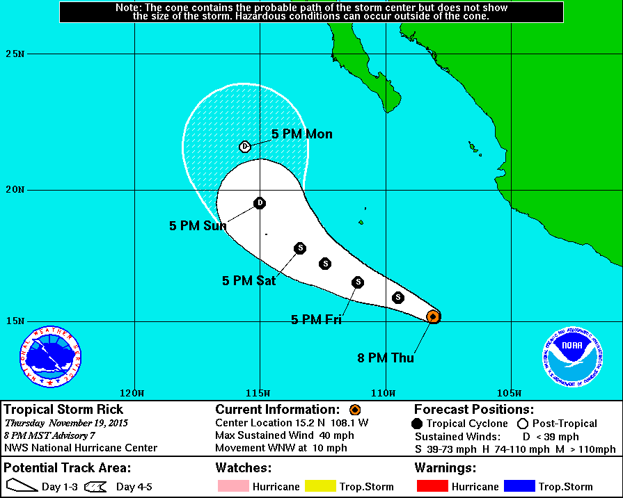
First up is a fun sized NW swell filling in on Monday for shoulder high sets around town and head high waves in SD.
On it's heels is a small late season S swell for waist high waves in SD and chest high sets in the OC.
And following that is another NW swell towards Thursday for more chest high waves and larger sets in SD. The only fly in the ointment may be another weak cold front coming through on Tuesday but it won't be a big storm at this point.

WEATHER:

As mentioned above, we have a low pressure system in southern California tonight and it's been generating cool air temps and breezy NW winds. That will hold through Friday with another shot of showers late Thanksgiving evening. Our current rain total from last night's storm wasn't impressive- only 0.10" of rain- so I'm still holding my breath for a real El Nino drencher (and I'm getting blue in the face). The weather cleans up Saturday through Monday and another weak cold front rolls through on Tuesday. Probably not breezy like today's system, but maybe a shot at a tenth of an inch of rain again. The 2nd half of next week should be pleasant and seasonal for December. Make sure to keep up to date on the waves/weather at Twitter/North County Surf. 
 
BEST BET:
Monday or Thursday with new NW swells and clean weather.

NEWS OF THE WEEK:

There’s been a lot of talk lately about sharks worldwide which have wreaked havoc at local beaches. From the young surfer killed at Reunion Island, to the shaper on the North Shore who lost his leg, to the 20 great whites seen in a pack off San Francisco, to the visiting Japanese surfer who lost his life in Australia, sharks are getting more press than Trump (thankfully in a sad sort of way). Also getting a lot of press lately are drones. From unmanned drones tracking terrorists to home flown drones buzzing your neighbors, the mini planes in the skies above seem to have a million uses. So where the heck am I going here with the whole shark/drone thing?! The Guardian reported recently that shark-tracking drones are being deployed to protect Australia’s beachgoers following a series of attacks on surfers. Trials will begin next week as part of a strategy by the New South Wales (NSW) government, which will also see high-tech drum lines installed to allow sharks to be hooked, tagged and released further out to sea. The drones will feed images with GPS coordinates back to operators looking for sharks, with the first field tests being conducted off Coffs Harbour. The first of the drum lines will be installed at Ballina, where a 20-year-old local surfer, Sam Morgan, was bitten by a bull shark earlier this month, and where a surfer from Japan, Tadashi Nakahara, 41, was killed by a shark in February.

The baited drum lines, previously used in the shark-infested waters of Réunion Island, instantly alert monitors when a shark has been hooked so it can be swiftly released and moved, unlike traditional lines that are checked intermittently. Helicopter surveillance is being increased as the main summer holiday season gets under way and politicians wrestle with how to balance protecting swimmers and surfers while acting in the best interests of the sharks. The trials are part of a $16 million five-year strategy to combat shark attacks that will include real-time tracking of tagged sharks using 4G technology, with 20 listening stations being built along the NSW coast at known shark attack locations. An app, called SharkSmart (yes, there’s an app for that), will allow members of the public to receive shark alerts in near real time on mobile phones and tablets. Eco-friendly barrier nets will also be installed.

There’s no easy way to reduce shark attacks, but the Australian government’s approach was to use available science and emerging technologies. In total there have been 14 shark-related incidents, one fatal, on the NSW north coast this year. “These are the first of several trials that will get under way across the state’s beaches this summer as we take an integrated approach to working out a long-term solution,” Niall Blair, NSW Minister for Primary Industries said in a statement. He told the Australian Broadcasting Corporation (ABC) the high-tech drum lines were more humane than the traditional lines that have been used in Queensland and Western Australia. “We think this is a bit of a game changer for Australia.” However, he agreed there was nothing to stop a shark from returning to the area. Other than a lack of parking, angry locals, or a line-up clogged with stand up paddle boarders. (Wait- that's my reason for not coming back to a surf spot). Regardless, the NSW premier, Mike Baird, said the approach was based on science, not emotion.

Shark-spotting helicopters will fly for at least three hours a day in certain areas during the peak holiday season. Environmental groups have expressed concerns over the drum lines, saying they put dolphins, turtles and non-dangerous sharks at increased risk of injury or death. “Putting the drum lines into a marine park is of concern because there are a large number of dolphins, and critically endangered grey nurse sharks, and turtles, and other things that are likely to become entangled,” Sharnie Connell, founder of the campaign group No NSW Shark Cull, told ABC News. There have been calls for independent monitoring to ensure animals or marine life trapped on the drum lines are released within two hours. The Ballina MP and the NSW Greens spokeswoman for the marine environment, Tamara Smith, has said she will be seeking to join monitoring crews throughout the trial period.

It will be interesting to see how these systems work and if they can be applied to beaches around the world, especially here in the U.S.

PIC OF THE WEEK:

Chris Burkard is one of my all-time favorite photographers. Not only does he take great surf shots, he also has an incredible eye for scenic shots. Today's Pic of the Week combines both; a fun looking empty line-up with a brutally cold snow-capped mountain. One of the few places on earth you can get a few waves in the morning and snowboard before dark; the Big Island and Southern California come to mind as a couple others- a lot friendlier than this bear and orca infested local in Alaska. For more of Chris's work, check out his website here.

Keep Surfing,

Michael W. Glenn
1st Place
Mike Glenn 2016 Swimsuit Calendar Is On Sale Now!
Convinced Hendrix to Hear Surf Music Again

Thursday, November 19, 2015

THE Surf Report- Early Edition


Thanksgiving is being replaced this year by Groundhog Day.

SURF:
Seems like we've been in a rut lately. The past month has produced rain starved storms dropping down from the N with gusty winds and bumpy surf, then high pressure sets up, and we're back to great weather and small surf. EVERY DARN WEEK. I think we've had that scenario 3 times now. And guess what- it's going to happen again next week. Groundhog Day! I'm going to start replacing the seals at the Children's Cove in La Jolla with Punxsatawney Phil. Today we had small waist high NW windswell with small knee high SW groundswell.
Look for more of the same this weekend- and great weather.
Water temps are still 5 degrees above normal at 66 degrees and tides the next few days are about 5' at sunrise, down to 2' at lunch, and up to 4' at sunset. Beware the tides though mid-week; we should hit 7' in the mornings and down to -1' after lunch, a full 8' swing.

FORECAST:

Monday starts off small again and Tuesday isn't any better, then we start to get a pick up out of the NW by Wednesday. Remember that storm last Monday that brought double overhead NW windswell and 50 mph wind gusts in San Diego? Looks like we have more of that late Wednesday into Thanksgiving. I don't think the wind will be as strong (most likely 30 mph) or the surf that large (probably 8' instead) but it will be a total mess regardless. But hey- you're supposed to be socializing with the grandma anyway on Turkey Day so who cares. After that it stays breezy through the end of the week.

There's a couple more storms on the charts in the northern AND southern hemispheres but we most likely won't see swell from them until the end of the month or early December.
Of special note is Tropical Storm Rick off mainland Mexico tonight. If you'll remember from THE Surf Report last week, I mentioned that due to the strong El Nino conditions, don't be surprised if we got another storm forming down there so late in the season. Lo and behold- Rick formed a couple days ago. Unfortunately, his winds are forecasted to only reach 40-50 mph and stay under Cabo, so we won't get any surf from it. I give it an A for effort though forming a week before Thanksgiving.

WEATHER:

As mentioned at the top of THE Surf Report, our weather pattern has been in rut with windy storms sandwiched between sunny days. We've got great weather on tap this weekend with the fog returning by Monday and Tuesday being a transition day. Wednesday the winds kick in again and we've got a chance of showers lasting into Thanksgiving. Cool breezy weather will last in to Friday. After that we start to roll into December and I'm hoping the real rain producing storms finally arrive and get us out of Groundhog Day.  Make sure to keep up to date on the waves/weather at Twitter/North County Surf.
 
BEST BET:
Do you like sunny skies and tiny surf? Then get it tomorrow! Or windy cloudy days with overhead lumps? Then get it Thursday!

NEWS OF THE WEEK:

As we wait for the ‘El Nino Winter’ by basking in summer-like 80 degree sunshine and water temps that feel more like the last day of school than Thanksgiving,  the National Oceanic and Atmospheric Administration reported recently that a key indicator for the strength of El Niño has reached a record high. Just more hype for the weather pattern known for causing extreme droughts, storms and floods becoming one of the strongest ever.

As we all know by now, El Nino is driven by warm surface water in the eastern Pacific Ocean and its strength is measured by how much higher temperatures are over a three-month average. In the week ending Nov. 16, temperatures in the Nino 3.4 region (the area SE of Hawaii on the equator), were 3 degrees Celsius (5.4 degrees Fahrenheit) above average. It was the highest reading in data that goes back to 1990, Mike Halpert, deputy director of NOAA’s Climate Prediction Center said.

The previous highest reading was 2.8 degrees Celsius above average (5.04 degrees Fahrenheit) in the week of Nov. 26, 1997 (the strongest El Nino on record).  However, El Niño-related impacts have been occurring around the globe for months already, and will continue for several months after the warmest temperatures occur in the tropical Pacific Ocean. For example, during the 1997-98 El Niño, the Niño3.4 Index peaked at 2.33°C (4.19 F) in November and the most substantial U.S. effects occurred through the early spring of 1998.

In case you’re unimpressed by even a 2°C (3.6°F) change, let’s do some math (pop quiz hot shot)! The area covered by the Niño3.4 region is a little more than 2.4 million square miles. One cubic meter of water weighs 1,000 kg (2200 lbs). So the top two meters (6.6 feet) of the Niño3.4 region contains about 12 quadrillion kilograms (about 13.6 trillion tons) of water. The energy required to raise one kilogram of water one degree Celsius  is 4.19 kilojoules (Have I lost you yet? Don’t worry- here comes the good part). A 2°C increase in just the top two meters of the Niño3.4 region adds up to an extra 100 quadrillion kilojoules (95 quadrillion BTUs). What?! Answer: THAT’S ABOUT EQUAL TO THE ANNUAL ENERGY CONSUMPTION OF THE UNITED STATES. That’s a lot of fuel for the fire. Now you know why our storms during an El Nino are supercharged.

As mentioned above, El Niño conditions normally reach maximum strength between October and January, then persist until early spring. As far as predictions go from NOAA, they’re expecting the storms to start rolling through in December and peaking in January/February. Considering the weather has been fantastic this fall with not a drop of rain in sight (figuratively speaking), we look to be on track.

Even though the water temps are 5.4 degrees Fahrenheit  above normal in the 3.4 region, NOAA’s Halpert pointed out that the record was only for the weekly value and that El Niño is eventually ranked by the peak of a 3 month value. “So we won’t know exactly where this event ranks until sometime next year,” he said. Another indicator, the Nino 4 value, also touched the largest value recorded at 1.7 degrees Celsius, NOAA said. The World Meteorological Organization said three-month averages would most likely peak at over 2 degrees Celsius above normal over the next few months. So until then, we wait.

PIC OF THE WEEK:

I love it when buddies of mine go to some faraway exotic places and send me pics of what I missed. Like this gem in Indo. He said he got it 4' some days and 12' on others. No crowd either. And the water was 80! I don't care though. Seriously. I've got my little slice of heaven called Cardiff this weekend. Sure it's going to be small and parking will be tough. And I'm wearing a wetsuit again. Yikes! And there's like 50 rabid stand up guys... Oh who am I kidding.

Keep Surfing,

Michael W. Glenn
Admirable
Reprising Bill Murray's Role As Phil Connors in Groundhog Day 2
Thankful For Surfing

Thursday, November 12, 2015

THE Surf Report- Early Edition


Or 'Late Edition' since I dropped the ball last week.

SURF:
Sorry for the missing THE Surf Report last week. I went to San Fran to surf some fun waves (and duck diving in 58 degree water- not fun).

Had some fun surf here though on either side of the cold front on Tuesday. Today we had clean weather with a building but small SW and smaller background NW for chest high waves.

The SW hangs around this weekend from a late season storm off Antarctica and we'll get shoulder high sets towards the OC. Sunday afternoon the NW starts to pick up but we also have windy conditions from yet another cold front entering our window (more on that below in the WEATHER section). Water temps are starting to drop from all the cold fronts lately but are still hanging around in the mid 60's.
And tides the next few days are 4' at sunrise, up to 5.5' mid-morning, and down to 0' at sunset.

FORECAST:
After the fun surf Saturday and messy conditions late Sunday, Monday is bumpy as the cold front moves through the region. On the bright side it should be overhead. Tuesday will have leftover NW windswell for shoulder high waves and the rest of the week looks... small.

There's nothing going on in the Southern Hemisphere of any significance and charts are only show some jumbled energy in the north Pacific. Best case is to see some chest high NW late next week. So in the meantime, don't take tomorrow for granted!

WEATHER:
This is the part of the program in which I usually complain about our lack of an El Nino winter. But not today! I'm being optimistic as technically it's still fall and the peak of El Nino is about a month away. And the biggest El Nino of all time ('97-'98) didn't unleash it's fury until late winter/early spring. So we've got plenty of time people! In the meantime, we've got great fall weather on tap this weekend with a mild 'Santa Ana' condition. Look for temps in the low 70's along the coast during the day and high 50 at night. We have yet another 'dry' cold front forecasted to sweep through late Sunday which will give us a small chance of showers and gusty winds into Monday. Then the Santa Ana returns the middle of next week for more sunny skies and warm temps. And when our El Nino finally hits with torrential rain and monster surf, I'll let you know. Make sure to keep up to date on the waves/weather at Twitter/North County Surf.

BEST BET:
Get it early this weekend before the storm moves in!

NEWS OF THE WEEK:
Even though our Eastern Pacific hurricane season seems to have run its course, the Accumulated Cyclone Energy, which measures the combined strength and duration of tropical storms and hurricanes, was 50% above normal this year. Not too shabby. We had 20 named storms with 10 having sustained winds over 100 mph and 7 of those with winds over 140 mph. And one- Patricia- steamrolled Mexico’s southwest resort coast as the strongest hurricane ever recorded  in the Western Hemisphere with sustained winds of 200 mph.

Phil Klotzbach of Colorado State University had this to say about the wild Pacific hurricane season: “So far this year, there have been a total of 21 Category 4 and 5 storms (winds over 131 mph) in the North Pacific (i.e. Eastern, Central, and Western Pacific), shattering the old record of 17, set in 1997 (the biggest El Nino of all time).And all these storms almost certainly owe their strength to a monster El Niño stacked atop climate change.

Wired Magazine reported recently that Patricia’s 200 mph winds were so strong that it technically could be considered a category 6 storm if the Saffir-Simpson scale went that high (the highest on the scale is a category 5 at 156+ mph). In addition to its unprecedented winds, Patricia broke the record for lowest pressure in any hurricane on record. With a minimum central pressure of 880 millibars (25.99 inches of mercury) at the 4 a.m. CDT advisory Oct. 23, Patricia broke the record of 882 millibars set by Wilma in the Atlantic Basin almost exactly 10 years earlier. Around 1 p.m. CDT Oct. 23, the minimum central pressure reached its lowest point, 879 millibars (25.96 inches of mercury).

“First of all, when you have an El Niño in place the surface waters are going to be very warm,” says James Kossin, atmospheric research scientist at NOAA’s Center for Weather and Climate in Wisconsin. And this year’s El Niño—ranked as one of the strongest on record—is affecting waters that are already warmer, due to decades of climate change. “This is a fairly good example of what we expected to happen,” says Kossin. “The theory and models said one thing global warming would do is have the strongest storms get stronger.”

Warm water is like gasoline for a hurricane’s engine. Atmospheric conditions help it stay revved. “Hurricanes are really just rings of thunderstorms, and in order to be really efficient the air needs to be vertically stacked in order to properly converge heat into the middle,” Kossin says. An undulating band of warm equatorial air, called the Intertropical Convergence Zone, kept the eastern Pacific’s atmosphere stable enough for all that oceanic warmth to convect its way to Patricia’s center.

But people in the path of Patricia’s Mexican landfall caught a small break.- vertical wind shear. When the winds in the lower, middle, and upper atmosphere are moving at different speeds, or in radically different directions, it disrupts a hurricane’s convection, which helped quelch Patricia’s engine before it hit land. Plus, Patricia headed east, where mountains knocked it down even further. But it still dumped rain. A LOT OF RAIN- and even produced flooding across large areas of Arkansas, Louisiana, Mississippi, and Texas.

The waters in the Eastern Pacific are still well above average when it comes to temperature- and our hurricane season still has 18 days left; so there’s still a chance for more storms to form. Don’t believe me? Ask Tropical Storm Omeka which formed on December 18th in 2010. Wouldn’t that be a great Xmas present this year…

PIC OF THE WEEK:
There are just so many things completely wrong with this photo. Is it the swirling boil in the background just waiting to release your fins on a bottom turn? Is it the 4' speed bump formed by the water draining off the reef? Or is it the lip cascading down like the teeth of a Great White shark? Whatever it is, I'll pass.

Keep Surfing,

Michael W. Glenn
Cream of the Crop
Playing 3rd Stormtrooper From the Left In The Force Awakens
Offering THE Surf Report For Free on Black Friday