Thursday, February 24, 2022

THE Surf Report


I Relish The Challenge.

SURF:


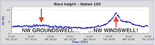
I'll be the first to admit- I don't mind storm surf. There's plenty of waves, the shape is peaky, and you have it to yourself. On the flip side, if you don't mind dirty water, blown out conditions, and blinding rain, then welcome to the club! Now that the storm has left the building, today saw small peaking SW swell and quickly dropping NW windswell for chest high sets. For Friday/Saturday, both swells will be on their way out and we're left with waist high combo swell and great conditions. 


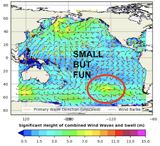
Luckily for us, we've got a new small but fun WNW groundswell showing Sunday afternoon for chest high waves and shoulder high in SD. And the weather will continue to be great. So we got that going for us. And here's the tides, sun, and water temps for the next few days:
  • Sunrise and sunset:
    • 6:19 AM sunrise  
    • 5:44 PM sunset  
    • FYI- Daylight Savings is coming up quick- Sunday, March 13th...
  • With the NW wind lately, water temps are holding in the high 50's. 
  • And we've got a bit of a tide swing this weekend:
    • 5.5' at sunrise
    • -1 after lunch
    • 3.5' at sunset
FORECAST:
The new WNW from Sunday peaks on Monday for more inconsistent chest high surf in N County SD and shoulder high waves in southern SD. 


For Tuesday, we have a small SW filling in for chest high surf towards the OC and then mainly small waist high NW/SW for the remainder of the week. 


Next weekend isn't looking to promising but we may see a small NW arriving Sunday and building through Tuesday for shoulder high surf. 


And take it with a grain of salt- because I don't trust the really really really long range models- but we could have our first solid SW swell of the season around the 12th of March for overhead waves. I won't believe it though until I see it. 

WEATHER:


Not the biggest storm yesterday but anything helps during our drought. Most spots along the coach received 1/4" to 3/4" of rain and the mountains received around 12" of snow. Wind gusts along the coast were 30-40 mph and peak winds in the mountains were 65-75 mph. Looks like we're due though for more warm sunny weather in the near term as high pressure is setting up shop for the weekend. Look for temps in the mid-40's in the mornings and mid-70's in the afternoons. Models hint at a cooling trend for the 2nd half of next week but no concrete evidence of rain yet. If anything changes between now and then, make sure to follow North County Surf on Twitter!

BEST BET:

Sunday with nice weather and a fun NW, Tuesday with a small but fun SW and nice weather, or maybe fun NW late next weekend. 

NEWS OF THE WEEK:


I'm sure you've heard by now of the multiple wave pools being built/proposed in the southern California desert. It's about time considering there's at least 10 around the world we can't visit unless you take a 3rd mortgage out on your house or sell your 1st born. So that begs the question, is there anything being built closer to home, like within 30 minutes of Orange County or downtown San Diego? If everything goes according to plan, there just might be. Here's the San Diego Union Tribune with the latest:

Ocean Kamp, a resort community to be built around an artificial surfing lagoon in the San Luis Rey River valley of Oceanside, CA is in our sights... but running a few months behind schedule.  Planners have asked for more work on the plan and as a result the construction start has been pushed back, developer Mike Grehl of N4FL Worldwide said in a recent presentation to the Oceanside Chamber of Commerce.

"We got a round of comments (from the city) that were somewhat unexpected," Grehl said. "We are definitely delayed, which is really unfortunate. ... It created a little roadblock for us, but we'll get through it. At the very end, when you are almost at the finish line, is when a lot of scrambling starts happening."


The developer had hoped to go to the Oceanside Planning Commission for approval in December 2021, but that "kind of slipped away," he said. The project would only go to the City Council if the Planning Commission's decision is appealed. The project has strong support from the city's business community, he said. The concept includes a high-tech artificial surfing lagoon as the centerpiece of a resort with up to 700 homes, 300 hotel rooms, and related offices, retail businesses and more on the 92-acre site of the former Valley Drive-In theater, just off state Route 76 at Foussat Road.

A Jan. 5 letter from the Oceanside Planning Department outlined dozens of conditions remaining to be met and things to be done before the project can be approved by the city. The letter includes a list from the Water Utilities Division with 60 conditions to be met, such as obtaining the U.S. Army Corps of Engineers approval of utility lines along the river levee and the city Fire Department's approval of emergency vehicle access routes. It asks the developer to identify all the existing groundwater wells on the property, the locations of all the city water meters to be installed for the project, and other details of water, sewer and safety systems.

Every condition on the list is part of the normal review process, City Planner Sergio Madera said Thursday. "There was nothing new," Madera said. The city and the developer have been working together on the project for more than two years. "We're at the end of a pretty long review cycle," he said. "We're still dotting the i's and crossing the t's. We're excited about the project and hoping to get it to the decision makers."

Former Oceanside Councilmember Chuck Lowery, asked about the project Friday, said he was glad to see the city press the developer for details. "Now is the time," Lowery said. "You can't ask for it after it's built." He expects the wave pool concept to be "incredibly successful," he said. However, while it may be an economic boon to the city, he had reservations about how accessible it might be to the average Oceanside resident. "People don't realize it's probably going to cost them $500 every time they take their kids and maybe the neighbor's kids" to surf the wave pool, Lowery said. The few existing wave pools around the country are popular, but expensive. Surfing sessions generally cost $60 to $90 an hour per person, though pricing has not been set for Ocean Kamp.

Grehl said the company hopes to open the resort in the spring of 2024. He encouraged the Chamber and the local business community to get behind the project and push for its approval by the city. Opposition to the project so far has been minimal. A few residents have been critical of the expected traffic, the water consumption or the location next to the Oceanside airport. But so far there has been no official public hearing, which would happen at the city Planning Commission level, and most people have liked the idea at the developer's community information meetings.


The San Diego North Economic Development Council and the Oceanside Chamber issued a joint statement in support of the project. "Ocean Kamp will be an exciting destination that embodies the North County lifestyle and creates substantial economic, tourism and community benefits for the entire region," Development Council CEO W. Erik Bruvold said in the written statement. "The synergies with the region's active sports, craft brewing and innovation ... and the importance of new housing make Ocean Kamp an ideal addition to the Oceanside economy."

The developer, N4FL, estimates that the project will create more than 1,500 permanent jobs and generate $81.3 million in tax revenue over 10 years.  The hotel, located on a beach at the end of the 4.5-acre wave pool, will have 228 rooms in the main building, 40 separate "casitas," and a park-like arrangement of rental Airstream campers. In addition to surfing, the resort will have rock climbing, stand-up paddle-boarding, yoga, and mountain biking with connections to the nearby trails along the San Luis Rey River. 

The development will include up to 700 homes in a mixture of townhouses, rowhouses and small single-family homes, Grehl said. Plans call for 5 percent of the project's required affordable housing to be built on site, and the developer will pay in-lieu housing fees for an additional 5 percent.

Also included is a 25,000-square-foot community center to host weddings, conferences and industry events, and 20 acres of the site will be maintained as open space. "Ocean Kamp's vision will be a complementary extension of all the benefits of living and working in Oceanside," Chamber CEO Scott Ashton said in the joint statement. "It will also provide needed inclusive housing opportunities, spaces for local businesses to grow, as well as tourism and event facilities that will collectively be a long-term economic driver for Oceanside."

The four-screen drive-in theater that stood on the property for almost 50 years closed in 1999 and was demolished in 2016. The city approved an environmental impact report for a previous project called The Pavilion on the site in 2008 that would have been the largest shopping center in Oceanside with multiple big-box anchor tenants. But the shopping center idea lost its luster as online merchandizing continued to grow, and The Pavilion was never built.

Encinitas-based Zephyr Partners bought the property in 2018 and developed the Ocean Kamp plan based on the artificial wave concept. Then in 2020, Zephyr handed control of Ocean Kamp to N4FL Worldwide, also known as N4FL development, with offices in Encinitas and Rancho Santa Fe. Grehl, N4FL’s vice president, is a former senior vice president at Zephyr, where he helped develop the wave resort plan.

PIC OF THE WEEK:


Not a bad sandbar if you ask me. 

Keep Surfing, 
Michael W. Glenn
Champion
American Royalty
Swell Adviser

Thursday, February 17, 2022

THE Surf Report


Good To See You Again Ol' Man Winter.

SURF:

From 'summer' to winter in the blink of an eye. Almost 90 degrees on Sunday and down to 60 on Tuesday. I think I got whiplash. 


Not much surf to start the week- and a bit of a mess on Tuesday- but lots of fun surf and cleaner conditions returned by Wednesday. 


For the weekend we've got leftover NW tomorrow with peaking SW. Not the biggest but expect fun peaky waves most everywhere. For Saturday it's mainly leftover SW/NW for chest high sets and about the same but less consistent on Sunday. And here's the tides, sun, and water temps for the next few days:
  • Sunrise and sunset:
    • 6:27 AM sunrise (paddle out at 6 AM?)
    • 5:38 PM sunset (paddle in at 6 AM?)
  • With the NW wind lately, water temps are back to the high 50's. 
  • And here are the tides this weekend:
    • 1' at sunrise
    • 4.5' before lunch
    • 0' late afternoon
FORECAST:

Might have to turn on the ol' EBS (that's the Emergency Boardriding System for you people in the know) in the near future- but we need to get through a bit of weather first. 


On Monday we start to see a new NW fill in later in the day but also winds increase from an approaching cold front. Tuesday looks to be solid but most likely windy and bumpy along with showers. Wednesday is questionable as the front exits the region so it could be clean or it could be bumpy for the head high NW. 


We also have a small SW filling in on Wednesday. Thursday may be the day to turn on the EBS as we should have peaking SW and leftover NW for shoulder high waves. Our next small NW looks to be filling in Saturday for chest high waves (bigger towards SD) and about the same Sunday the 27th. 


For the long range, the EBS may need to be turned on again and forecast charts show a good NW around Monday the 28th and a good SW towards Wednesday, March 2nd. Let's hope!

WEATHER:


Good to see wind, showers, and snow this week. We've got nice weather this weekend and then more of that wet 'n' windy stuff is anticipated to return next week. Look for the winds/clouds to increase late Monday and then showers most of the day Tuesday. By Wednesday, we should start cleaning up and then it's anyone's guess after that. If anything changes between now and then, make sure to follow North County Surf on Twitter!

BEST BET:

Friday with fun combo swell and great weather. Or next Wednesday with better combo swell BUT suspect winds (or wait until Thursday). OR... good NW 2/28 or good SW 3/2!

NEWS OF THE WEEK:


Whether you believe in climate change or not, you have to admit our weather out West has been WEIRD. Whether it's 90 degree air temps in San Diego for February, or the lack of snow in our mountains this winter, British Columbia seeing Death Valley like temps of 120 this summer, and Colorado seeing wildfires in the middle of winter- we're definitely warming up. And what does a warming Earth mean? Rising sea levels. The National Oceanic and Atmospheric Administration (NOAA) just came out with a report on what to expect the next 20-30 years and it's an eye opener:

Sea level rise is accelerating rapidly and U.S. coasts could on average see another foot of water by 2050, according to a National Oceanic and Atmospheric Administration report released Tuesday.

“The United States is expected to experience as much sea level rise in 30 years as we saw over the span of the entire last century,” Rick Spinrad, the NOAA administrator, said. “Current and future emissions matter, but this will happen no matter what we do about emissions.” The report predicted 10 to 12 inches of additional sea level rise by midcentury, though projections for specific regions and communities vary because of changes in land height. Some parts of the coastal U.S. are subsiding, while others are experiencing uplift or rebound.


Global warming — which is driven by the use of fossil fuels — is the primary cause of sea level rise. Scientists have been observing the trend for decades as water expands because of higher temperatures, as glaciers melt and as ice sheets are diminished. Previous reports have provided broad ranges of how much the seas will rise, but the science is now more specific and can provide a more assertive view of how the world’s coasts will look in a few decades, regardless of future emissions.   

“2050 is in our headlights, and we can speak with confidence and clarity about what will occur,” William Sweet, a NOAA oceanographer, said. Rising seas could hamper economies, cause more dramatic flooding, inundate freshwater areas with salt and cause a host of other problems. About 40 percent of the U.S. population lives in a county along the coast. 

Coastal flooding risks are expected to rise dramatically by midcentury, the NOAA experts said. “A single flooding event, one that now happens every four to five years on average in coastal communities in the southeast United States, will happen four to five times every year,” Nicole LeBoeuf, an assistant administrator for NOAA’s National Ocean Service, said. So-called sunny day floods — when coasts are inundated not due to storms, but because of high tides — are projected to increase dramatically, too.


The analysis, which was published in cooperation with other federal agencies like NASA, is designed to help communities plan to move vulnerable public buildings away from the coast, prevent construction in areas where inundation is likely and help retrofit homes and other buildings for a flood-prone future.

The data will also help form a baseline for insurance and real estate risk adjustments over sea level rise in the private sector, LaBoeuf said. The report’s findings are based on tide gauge data, satellite data, increasingly powerful climate modeling and other coastal monitoring measurements.

Sea level rise will vary widely by region. The East and Gulf coasts, in general, can expect more sea level rise than average because of coastal subsidence — sinking land. The West coast will see less dramatic changes. Beyond 2050, the possibilities broaden widely and scientists expect the world’s emissions choices to have a substantial impact on the trajectory of rising seas.  


The report includes five scenarios for sea level rise by 2100. The lowest limits sea level rise to about two feet in comparison to 2000. The highest scenario predicts more than 7 feet of additional sea level rise since the turn of the millennium. Some climate change processes, such as Antarctic ice sheet instability, are not well understood and scientists acknowledge that there are surprise scenarios that could accelerate how fast seas rise.

NOAA also just came out with an interactive map to show what your hometown will look like with minimal (1') sea level rise and worst case (10'). Basically the lagoon in Cardiff will look like high tide all the time at a 1' rise and a 10' rise? One big lake with Highway 101 at Georges underwater and the ocean pushing up the lagoon into Olivenhain. Wild. And don't even ask about low lying cities like PB/Mission Beach, the Newport Peninsula, HB, Long Beach...

PIC OF THE WEEK:


As you stare wistfully at this long left in warm tropical waters, consider the small beach bar on land where you can quench your thirst with a frosty beverage at the end of your session. Damn those people!  

Keep Surfing, 
Michael W. Glenn
Zesty
Least Known Member Of The Brat Pack
Surfed Trestles With Just Me & Zuck Yesterday In The Metaverse

Thursday, February 10, 2022

THE Surf Report


Welcome To Bizarro World! 

SURF:

You know that our weather in the summertime isn't this nice; right? We're usually socked in with fog. The sun is appreciated though this time of year- but just not this much. So what should we do about it? Enjoy it while it lasts. 


Had some fun surf the past few days at the best spots in southern SD and the OC. Looks like more of the same this weekend; leftover SSW swell and background NW for waist to chest high surf- and best spots in SD/OC again shoulder high+. And here's the tides, sun, and water temps for the next few days:
  • Sunrise and sunset:
    • 6:34 AM sunrise
    • 5:32 PM sunset 
  • With the hot sunny days this week, water temps have nudged up slightly to 60 again.
  • And here are the tides:
    • 5' at sunrise
    • -0.5' after lunch
    • Back up to 2' at sunset
FORECAST:

Looks like we have a slight change on tap for next week. Models are finally showing a moderate shift in our dominant high pressure and we could see a cold front head our way on Tuesday. 


As it does, NW windswell/groundswell will fill in for shoulder high sets- but it it could be windy/bumpy. That swell though should last most of the week. 


On its heels is another early season SW swell (similar to the one we're seeing today) for chest high sets in N County SD and shoulder high waves in the OC by Wednesday. That swell will last into Friday. 


Next weekend looks smaller but forecast charts show more shoulder high WNW around late Sunday. So maybe the SW swells/sunny weather will finally hibernate until summer and the showers/NW swells will arrive before winter is over... 

WEATHER:


If you haven't noticed by now, the weather is ALL screwed up. Almost 70 degrees at Big Bear this weekend?! It doesn't even get that warm up there in the summer! I may be exaggerating, but the point is- we're in big trouble- the brushfire in Laguna Beach is proof of that. The good news that we may see a weak cold front move through on Tuesday and showers are in the forecast. So look for nice weather this weekend, and showers early next week. Beyond that, I'm hoping we AT LEAST see cooler weather next week. Heck- we are in the middle of winter, aren't we?!  If anything changes between now and then, make sure to follow North County Surf on Twitter!

BEST BET:

Friday with small but fun combo swell and great weather. Or the middle of next week with better combo swell BUT suspect winds. 

NEWS OF THE WEEK:


You probably could have guessed it- records were broken today for our air temperatures in Southern California. In particular:
  • Santa Ana at 90 degrees (old record of 88 in 2016)
  • Oceanside at 88 degrees (old record of 84 in 2002)
  • Vista at 91 degrees (old record of 86 in 2016)
  • Escondido at 89 degrees (old record of 88 in 1988)
The problem of course with this prolonged heat wave is that all the brush in our hillsides are drying out (when they should be getting soaked) as we head into our dry summer/fall, leaving us vulnerable to wildfires. So after starting out with a bang for rain this past fall, where do we stand now? Here's the latest:
  • Newport Beach: 5.64" so far, 83% of normal
  • Oceanside: 5.57" so far, 85% of normal
  • San Diego: 3.75" so far, 67% of normal
Since the bulk of our annual rainfall happens in the December to February timeframe, not seeing any rain in January and February is a big blow. In a nutshell, we're aiming for at least a total of 10" of rain. We can only hope for a few freak storms in March and April. Let's go Mother nature! 

PIC OF THE WEEK:


Doesn't look like much of a vacation spot; the land is arid, hot, and dusty. Probably got a few snakes and tarantulas to boot. But you'd be out in the ocean surfing that left 24/7 anyway, so who cares! 

Keep Surfing, 
Michael W. Glenn
Exec
Performing With Snoop At The Halftime Show!
Only Athlete To Medal At The Olympics In Snowboarding And Surfing

Thursday, February 3, 2022

THE Surf Report


Whoever Said 'Patience Is A Virtue' Didn't Surf.

SURF:


Not a big week for surf- but we did have offshore winds in the mornings- so that helped groom the fun waves we did have. For the upcoming weekend, La Nina is still in control unfortunately, so look for tiny surf and clean conditions again. 


South County SD though may see some waist high+ waves from a new small NW but I wouldn't clear your schedule for it. And here's the tides, sun, and water temps for the next few days:
  • Sunrise and sunset:
    • 6:40 AM sunrise
    • 5:25 PM sunset 
    • A bonus to these crisp clear days is that you can paddle out at 6:15 AM and paddle in around 6 PM...
  • With the recent offshore winds, water temps have dipped slightly to 58. Ouch.
  • And the tides- like the surf this weekend- are mellow: 
    • 1.5' at sunrise
    • About 4' mid-day
    • Back down to 1' at sunset
FORECAST:

The small NW for SD on Sunday fills in a touch more (?) for Northern SD County for waist high+ surf but that looks to be about it. The Southern Hemisphere looks to be bailing us out though as we've got a couple small SW swells headed our way next week. 


First up is a waist high SW in Northern County SD and chest high sets in the OC next Wednesday the 9th.


After that, we've got another similar sized SW arriving a week later on the 16th. And hopefully by that time, we'll see another fun NW. Only time will tell. 

WEATHER:


I was really hoping for a big rainy February but now it looks like we can throw that out the window. Most long range forecasts are showing high pressure in control and light to moderate off and on Santa Ana winds. So what does that mean for the short term? Mild Santa Anas tomorrow, again on Sunday, and most likely every few days next week. We could even see temps in the mid-70's late next week with lows in the mid-50's. If anything changes between now and then, make sure to follow North County Surf on Twitter!

BEST BET:

Small NW on Monday or small SW Wednesday the 9th/16th. Exciting, huh?

NEWS OF THE WEEK:


Seawater, water that makes up the oceans and seas, covers more than 70 percent of Earth's surface. Seawater is a complex mixture of 96.5 percent water, 2.5 percent salts, and smaller amounts of other substances, including dissolved inorganic and organic materials, particulates, and a few atmospheric gases. But where does it actually come from?

In the beginning, the primeval seas were probably only slightly salty. But over time, as rain fell to the Earth and ran over the land, breaking up rocks and transporting their minerals to the ocean, the ocean has become saltier.

Rain replenishes freshwater in rivers and streams, so they don’t taste salty. However, the water in the ocean collects all of the salt and minerals from all of the rivers that flow into it.

It is estimated that the rivers and streams flowing from the United States alone discharge 225 million tons of dissolved solids and 513 million tons of suspended sediment annually to the ocean. Throughout the world, rivers carry an estimated four billion tons of dissolved salts to the ocean annually.

About the same tonnage of salt from ocean water probably is deposited as sediment on the ocean bottom and thus, yearly gains may offset yearly losses. In other words, the ocean today probably has a balanced salt input and output (and so the ocean is no longer getting saltier).

And just a reminder, we all know that drinking seawater (i.e. saltwater) can be deadly. When humans drink seawater, their cells are taking in water and salt; human kidneys can only make urine that is less salty than seawater. Therefore, to get rid of all the excess salt taken in by drinking seawater, you have to urinate more water than you drank. 

PIC OF THE WEEK:


Is this doesn't look fun to you, then I guess you don't know what fun is. 

Keep Surfing, 
Michael W. Glenn
Leading Man
We Can Be Heroes, Just For One Day
Can Finally Hang Nine. Almost There!