Thursday, November 28, 2013

THE Surf Report- Early Edition


Early Edition 'cause I'm gettin' up early for Black Friday deals tomorrow! Um, I mean to crack that new swell...

SURF:
Finally! Some real waves to talk about. And the weather is cooperating too. We have a storm due W of us tonight that gave Nor-Cal some 20'+ surf today and head high waves for us tonight.
That swell is currently building and will peak 1st thing tomorrow for overhead surf most everywhere and 10' surf in SD. The storm that created this swell was supposed to move ashore tonight with rain but it will stay offshore- so clean conditions for us tomorrow. There is a slight chance of sprinkles but it won't mess up our clean conditions. By Saturday the swell will wind down to shoulder high sets and by Sunday it's chest high. Can't complain- it's been plenty flat around here lately.
Water temps are 61 and tides the next few days are around 6' at sunrise, down to 0' at 1pm, and up to 3' at sunset. Make sure to keep up to date on the waves/weather at Twitter/North County Surf.  

FORECAST:

After a great weekend of surf, we get a little breather on Monday then maybe a little shot of chest high sets from the NW on Tuesday. Wednesday backs off again then we're due for some NW windswell on Thursday for shoulder high waves in north county SD and head high sets in south SD. Unfortunately though we should get some breezy S winds towards Tuesday/Wednesday and rain as the next storm approaches. Looks to be junky until at least Friday then cleaner and smaller conditions next weekend.

WEATHER:

Just some high clouds tomorrow and a shot at sprinkles with not much wind. Looking pretty good for a surf. Clear your schedule! High pressure sets up over the weekend for temps in the high 60's and temps in the low 50's. Then things get interesting towards Tuesday when our first real cold storm plunges down from the Arctic next week. Looks like Tuesday to Thursday will be breezy, showers off and on, and COLD. High temps on Thursday may only be in the low 50's with temps at night in the low 40's. Too cold for the beach. High pressure should set up next weekend for clear skies and temps in the low 60's.

BEST BET:
Tomorrow! Overhead W swell, semi-clean conditions, and you're off work!

NEWS OF THE WEEK:

This Day In Weather History!!!!

2009: It rained in San Diego for the first time since 6/16! This ended a consecutive dry streak of 164 days in San Diego, which started on 6/17. This streak of 164 days is tied as the fourth longest dry streak on San Diego record. This day also marks the latest end to any dry streak on record. (The longest dry streak on record is 182 days from 4/8/2004 to 10/16/2004).

1989: Strong Santa Ana winds produced gusts to 70 mph at the Rialto Airport. Several tractor- trailer trucks were overturned east of Los Angeles.

1981: A storm that started on 11/27 and ended on this day dumped nearly two inches of rain in the LA area. Three feet of new snow were recorded at Big Bear Lake. Highway deaths resulted.

1975: The first winter storm of season was a heavy one. It started on this day and ended on 11/29. Up to two feet of snow fell in the San Bernardino Mountains, including 16 inches at Big Bear Lake. Twenty stranded campers were rescued after a few days. 12 inches of snow fell in Idyllwild, the greatest daily snowfall on record for November. This also occurred on 11/10/1982.

1970: A series of storms struck the region from 11/25 to 11/30 following large destructive wildfires in the San Bernardino and San Gabriel Mountains earlier in the fall. 9.17 inches of precipitation fell in Lake Arrowhead, 7.22 inches in Lytle Creek, 5.11 inches in Big Bear Lake, 5.02 inches in Palomar Mountain, 3.56 inches in San Bernardino, 2.63 inches in Redlands, 2.51 inches in Santa Ana, and 2.05 inches in San Diego. Flooding inundated streets and highways in the Rancho Cucamonga area. At least 60 homes were damaged by floods and debris flows.

1919: The low temperature was 36° in San Diego and 24° in Santa Ana, each the lowest temperature on record for November.

PIC OF THE WEEK:

THIS is what good surf in California looks like. Finally. 

Keep Surfing,

Michael W. Glenn
Best Man at 124 Weddings and Counting
Beat Joey Chestnut In a Turkey Eating Contest
Black's Friday: I'm Opening the Gate At Black's Tomorrow- Free Waves!

Tuesday, November 26, 2013

Surf Check

Another flat day out there with just a tiny SW swell trying to show in the OC for waist high sets and knee high NW down here. Beautiful day outside. Again. But still no surf.
Water temps are holding on at 62 degrees and the tides are pretty mellow with 3' at sunrise down to 2' mid-morning, and up to 3.5' at sunset.
Our weather is perfect again- albeit chilly- with just some high clouds overhead and not much wind. We're in for a change though as a storm currently sits offshore of the Pacific Northwest and will make a unique trajectory down the Pacific coast over water- instead of slamming into Northern California first. San Francisco may actually not see any rain from this as the storm is forecasted to move inland into Southern California instead. Look for showers on Thursday with WSW winds around 15-20mph. Rainfall should be around 1/4"-1/2"; slightly less than our last storm. Not a big storm to say the least but we do need the rainfall. And a little wet and windy weather on Thanksgiving as you stuff yourself and watch football is a good thing. Things will clear up Saturday through Tuesday then maybe another small storm the 2nd half of next week- along with some chilly temperatures in the low 60's during the day.
So the good news with this storm on Thanksgiving is that we'll get some surf from it. The bad news is that it will be windy of course. Best bet is to hit it early before the in-laws come over as well as getting on it before the winds kick in late in the day. Look for some head high sets in San Diego County from the W. Friday looks to be junky with more head high waves, then Saturday the swell drops as the weather cleans up.
Sunday and Monday look to be pretty small but we have some more NW windswell on the charts for next Tuesday. Nothing big but chest high sets in south county SD.

All in all some waves on Thanksgiving and a little bit of wet weather. Another thing to be thankful for!


Friday, November 22, 2013

THE Surf Report


I'm running out of ways to say 'flat'.

SURF:
Actually had a couple fun little waves last weekend (it's amazing how waist high surf now gets me all fired up) and the past few days unfortunately have been dead flat.
We had some NW windswell pick up last night but with the windy conditions and dirty water from the rain run-off, it's not worth paddling out. This morning the NW is backing off and we have some waist high waves. Look for smaller conditions this weekend (i.e. flat) but the sun should return by Sunday.
Water temps have stayed around 63 and tides the next few days are around 3' at sunrise, up to 5' at 11am, and down to 1' at sunset. Make sure to keep up to date on the waves/weather at Twitter/North County Surf. 

FORECAST:

Still looking pretty small the next 5 or so days. BUT... we do have a small storm on the charts mid-week that should move into Southern California towards Thanksgiving afternoon into Friday morning.
That storm will hopefully give us chest high sets from the NW on Thursday. But the storm will probably give us stormy conditions too. So look for rideable waves but blown out at the same time.
After that, models show a solid storm forming the middle of next week too which would give us a real NW swell towards next Saturday. The storm hasn't even formed yet, but I'm praying I can get off my groveller and surf a real board for a change!

WEATHER:

Kind of cool to see some wet weather around here. Even though it's not the gnarly El Nino stuff I dig, I'll take a change in the seasons. Looks like we have another couple cloudy showery days ahead and by Sunday it starts to clear up around here. Weak high pressure sets up early in the week then by Wednesday another low pressure moves into Southern California. If you like a wet and windy Thanksgiving (or a white Christmas), then next week is right up your alley.

BEST BET:
Maybe that small junky NW on Thanksgiving or if the models hold true- a real swell next weekend.

NEWS OF THE WEEK:

If the lack of surf isn't driving me crazy, the wacky weather is. Models last week showed high pressure setting up shop this past Wednesday but instead we got rain. And a fair amount. Here's some preliminary totals the past few days:
-Lake Arrowhead 5"
-Huntington Beach 0.37"
-Laguna Hills 0.82"
-Carlsbad 0.52"
-San Diego 0.91"

So where are we at for rainfall this time of year?
-Newport Beach: 0.57". 29% of normal (should be at almost 2" by now)
-Oceanside: 0.54". 27% of normal (should be almost 2" by now)
-San Diego: 1.25". 88% of normal (should be 1.41" by now)
As you can see above, the rainfall this season has been sporadic from location to location. Basically we're still below our norms BUT... our 4 wettest months are still ahead; December to March. So we've still got a shot to hit our normal of 10" a year. So you're telling me there's a chance...

BEST OF THE BLOG:

With the lack of surf and sunshine lately, I thought you needed a little stoke. So I decided to break into the Pic of the Week archives and set up 1 of (soon to be) many galleries. Feast your eyes on what real waves look like. And of course a mid-week Surf Check and an in-depth THE Surf Report; all of that and more in the blog below!

PIC OF THE WEEK:

Seriously, I have NO idea where this wave is. All I know is that's it's breaking pretty far out, there's a fair amount of water moving around, and there's those cool fingers of reef on the inside. If you know where this place is- I've got $20 for ya.

Keep Surfing,

Michael W. Glenn
#1
All Nighter With My Playstation 4
3 Career Interceptions Off Johnny Utah

Thursday, November 21, 2013

Stoke! Art Gallery 1

In case your new to the North County Surf blog, you may have not seen the images on today's story 'Stoke! Art Gallery 1'. I've been doing THE Surf Report for almost 20 years now (first it was a fax to friends, then an email blast, and now the web- I'm shooting for TV next) and for almost 15 of those years I've included a 'Pic of the Week' on the report. So if you've only been following THE Surf Report the past few years, you may have missed some the oldies but goodies here. Considering how bad the surf has been the past year, I thought you'd like to see what real waves look like- just in case they ever show up again. Like the shot above. Can't tell you where- but it is in north county. During the crazy swell/offshore wind combo we had back in January of 2003. Haven't seen it that good since. And probably never will.
This definitely isn't California. Lack of condos on the bluffs and not a Walmart in sight is the dead giveaway. Kind of cool the double point effect- the fast walls out the back then the slow lines in the cove. Something for everyone.
Another shot that isn't California. Actually think it's in the same part of the world as the right point picture above (Middle East/North Africa). Wonder why no one is out? Other than the fact it's a little unstable over there.
Such a great shot. Not the biggest waves but just round and rippable. And the lack of kooks helps too. Shot in New Zealand. Air is cleaner down there, crime is lower, and apparently the surf is better too.
Another shot from the underside of the world. Or are we the ones who are upside down? Still can't figure out why water in the toilet bowl down there spins in the opposite direction. Anyway, just a fun empty point break. Kind of like Swami's back in the 1700's.
Don't know exactly where this is. Wish I was there though. Think it's in Indo. No chartered yachts in the background so just the photographer looks like he scored here. Imagine backdooring this thing? You'd be soooooo pitted! Sorry, getting a little excited here.
Which way would you go here? The quick easy round left barrel? Or do you like to drive and weave? So maybe the right's the call. Either way, looks like a pretty good set up. Maybe try both and decide first hand. Maybe do it blindfolded like the 'Pepsi/Coke' challenge? Ok, maybe not blindfolded.
One of my all time favorite shots. Easily top 10. And that's a big statement considering my Pic of the Week has featured close to 1,000 lineups. So why is this so special? A few reasons. First- it looks like a pretty rippable left. Second, there's a lot going on in the shot; the trees, a couple points are in play, the color. And third and most importantly- it's in the Mediterranean- Italy to be exact. Pretty awesome.
Another shot from the underworld. Not exactly Australia though. And not exactly New Zealand either. And definitely not Antarctica (no penguins is the dead giveaway). But rather Tasmania. If you can handle the brutal cold and stormy conditions 51 weeks out of the year, then this is the place for you.
Speaking of cold and stormy, here's a pic of the exact opposite of Tasmania: Ireland. One of my favorite all time destinations. Heaps of points, lots of surf, lack of crowds, and the friendliest people on earth. Must be all the free Guinness. Well not free, but it flows from the fountains in the parks. True story. Ok, more like wishful thinking.

Enjoy the pics and keep praying we get some surf soon! And look for another Stoke! Art Gallery before the end of the year.


Tuesday, November 19, 2013

Surf Check


Oh boy. Where do I start. Hope you're sitting down for this. Ready? Ok, here goes. It's bad out there. Real bad. But it's been that way for awhile now- like 18 months- so you're kind of numb by now I assume. Anyway, here's the meat and potatoes:

Today we have small knee high surf from the NW/SW with south SD getting some waist high sets from the NW and the OC getting some waist high sets from the SW. Doesn't matter though- it's been windy well before dawn from the SW so it's pretty junky out there.

Tides are also playing havoc with the tiny waves and bumpy conditions. They're 3' at sunrise, up to 6' at 9am, and down to -1' at sunset. Water temps are holding at 63.


As far as our weather goes, we had a quick shot of showers last night from a weak passing cold front and we've got more on the way. Looks like up to 1/4" of rain coming late Wednesday into Thursday with maybe a couple more drops for Friday. The weekend looks to be partly cloudy and cool- with maybe some offshore winds from the departing low pressure system. Hopefully by early next week we'll be back to normal around here.

As far as our waves go, we had a promising SW on the charts last week that turned out to be a dud. The OC will only get some waist high sets from it late tomorrow into Thursday. Down here it's more of the same- just little NW windswell and windy conditions to boot. Charts though do show a slight increase in the NW windswell towards Friday/Saturday for maybe some waist high waves here in north county SD and chest high sets in south SD. Yahoo!

After that it's a big box of nothing for Xmas. Charts don't show any large organized storms headed our way from either the SW or NW so it's looking pretty bleak next week. Argh!


So until then, enjoy the small windy surf the next few days with hopefully some waist high+ waves the 2nd half of the week!


Friday, November 15, 2013

THE Surf Report


Lumpy, bumpy, and grumpy.

SURF:
Small scale NW/SW surf earlier this week started to pick up on Wednesday with a new NW windswell. By sundown last night, sets were chest high+ in north county SD and head high in south SD.
Today we have shoulder high sets in north county and overheads sets in south SD with strong S wind.
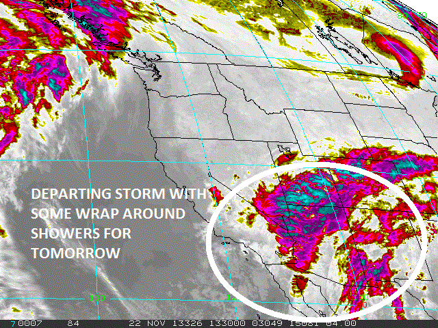
We should get more of a boost tomorrow from the NW for head high waves in north county SD and overhead+ surf in south SD- but the weather won't cooperate again (more on that in the Weather section below). Sunday things start to clean up and the surf starts to back off- but we'll still have fun waves. All in all some surf this weekend but junky conditions. Water temps have inched up slightly to 64 but may drop next week when the NW wind follows the cold fronts this weekend.
Tides the next few days are around 6' at sunrise, down to -1' at 2pm, and up to 3' at sunset. Make sure to keep up to date on the waves/weather at Twitter/North County Surf. 

FORECAST:
After a bumpy weekend of surf, the weather cleans up and the surf backs off. We'll have a slow decline from the NW and it's pretty small around here by Wednesday.
Amazingly, the southern hemisphere won't die and it looks like we have some chest high sets from the SW showing next Thursday the 21st with shoulder high sets in the OC.
We may also have a little NW windswell to greet it so the beach breaks may have some corners. And if a SW swell isn't odd enough for November, the lack of NW swells this time of year is- next weekend is looking pretty flat at this point. Hopefully the models are wrong.

WEATHER:

As you woke up this morning, you probably noticed the weather had already changed for the worse. Nothing major, but just more clouds, the winds were picking up, and a slight chance of showers are forecasted later today. Looks like that's pretty much the forecast tomorrow too. Sunday should be a transition day as the clouds start to depart and high pressure sets up early next week for sunny weather again and temps in the low 70's.

BEST BET:
Either some bumpy and windy NW on Saturday or cleaner conditions with the new SW next Thursday.

NEWS OF THE WEEK:

Greenhouse gases or El Nino? What’s really to blame for global warming? Might a natural shift to stronger warm El Niño events in the Pacific Ocean be responsible for a substantial portion of the global warming recorded during the past 50 years? According to new research at The University of Alabama in Huntsville (UAH), that could be the case. “Our modeling shows that natural climate cycles explain at least part of the ocean warming we've seen since the 1950s,” said Dr. Roy Spencer, a principal research scientist in UAH's Earth System Science Center and the new study’s lead author. “But we also found that because the globe has had more frequent La Niña cooling events in the past 10 or 15 years, they are canceling out some of the effects of global warming.” The paper detailing this research, “The Role of ENSO in Global Ocean Temperature Changes During 1955-2011 Simulated with a 1D Climate Model,” is scheduled for publication in the Asia-Pacific Journal of Atmospheric Science. The results also suggest the world will warm by 1.3 C (about 2.34° F) from a doubling of atmospheric CO2, which is only one-half of the warming expected by most climate researchers. General circulation climate models – such as those used to forecast global climate change – do not reproduce the tendency toward 30 year periods of stronger El Niño or La Niña activity, as are seen in nature. Spencer and co-author Dr. Danny Braswell used all of the usual climate modeling forcings – including carbon dioxide and other greenhouse gas enrichment – in their study, but also plugged the observed history of El Niño ocean warming and La Niña ocean cooling events into their model to calculate the 61-year change in global ocean temperature averages from the sea surface to a depth of 2,000 meters. “We used the observed ENSO (El Niño Southern Oscillation) history since the 1950s as a pseudo forcing factor of the model,” Spencer said. When they ran their ocean model without ENSO, they arrived at the same general conclusions as the more complex general circulation climate models. When they added data from past El Niño and La Niña events as only a change in ocean mixing, the model indicated a climate system that is slightly less sensitive to CO2-induced warming than has been believed. But the biggest change was when the model was allowed to change cloud cover with El Niño and La Niña in the same way as has been observed from satellites. The results suggest that these natural climate cycles change the total amount of energy received from the sun, providing a natural warming and cooling mechanism of the surface and the deep ocean on multi-decadal time scales. “As a result, because as much as 50 percent of the warming since the 1970s could be attributed to stronger El Niño activity, it suggests that the climate system is only about half as sensitive to increasing CO2 as previously believed,” Spencer said. “Basically, previously it was believed that if we doubled the CO2 in the atmosphere, sea surface temperatures would warm about 2.5 C,” Spencer said. That's 4.5° F. “But when we factor in the ENSO warming, we see only a 1.3 C (about 2.3° F) final total warming after the climate system has adjusted to having twice as much CO2.” It was previously known that Pacific Ocean warming and cooling events come and go in roughly 30-year periods of predominance, where El Niño warming events are stronger than La Niño cooling events for approximately 30 years, followed by roughly three decades where the reverse is true. During the period of this study, cooling events were dominant from the 1950s into the late 1970s. That was followed by a period of strong El Niño warming activity that lasted into the early 2000s. The current phase has seen increased La Niña cooling activity. Spencer said it is reasonable to suspect that the increased La Niña cooling might be largely responsible for an ongoing “pause” in global warming that has lasted more than a decade. If that is the case, weak warming might be expected to revive when this phase of the El Niño-La Niña cycle shifts back to a warmer El Niño period. The study was the result of a debate over whether clouds can be part of an active forcing mechanism for global warming, or are just a passive response to temperature change. “What we found is, to explain the satellite data we had to invoke a change in clouds nine months before the peak of either an El Niño or a La Niña,” Spencer said. “When the clouds change, it takes time for that to translate into a temperature change. “We get the best fit to the observations when we let clouds cause some of the temperature change. These cloud changes are occurring before the temperature starts to respond, so they can't be caused by the temperature changes.” Before an El Niño Pacific Ocean warming event, global cloud cover decreases, allowing more solar energy to reach the Earth's surface and be converted into heat. On the flip side, before a La Niña Pacific Ocean cooling event, cloud cover increases, shading more of the Earth's surface and reflecting an increased amount of solar energy back into space. While changes in cloud cover intensify the warming or cooling of these ocean events, Spencer and Braswell still found that two-thirds of the sea surface temperature changes during both El Niño and La Niña events are driven by changes in ocean mixing. But the one-third forcing by clouds turns out to be an important component, substantially changing the interpretation of how sensitive the climate system is to CO2 emissions.

BEST OF THE BLOG:

Best place to watch a surf video? No, not on the throne with your iPad. it's the La Paloma theatre in Encinitas. And it's due for some renovations after 85 years. Check out the story on the North County Surf blog. And of course a mid-week Surf Check and an in-depth THE Surf Report. All of that and more in the blog below!  

PIC OF THE WEEK:

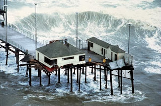
Another reason Maverick's is so dangerous- it doubles as a pterodactyl.

Keep Surfing,

Michael W. Glenn
Supercilious
San Diego Sports Fan. Unfortunately.
The Goofyfoot Munga