Not Out Of The Woods Yet.
SURF:

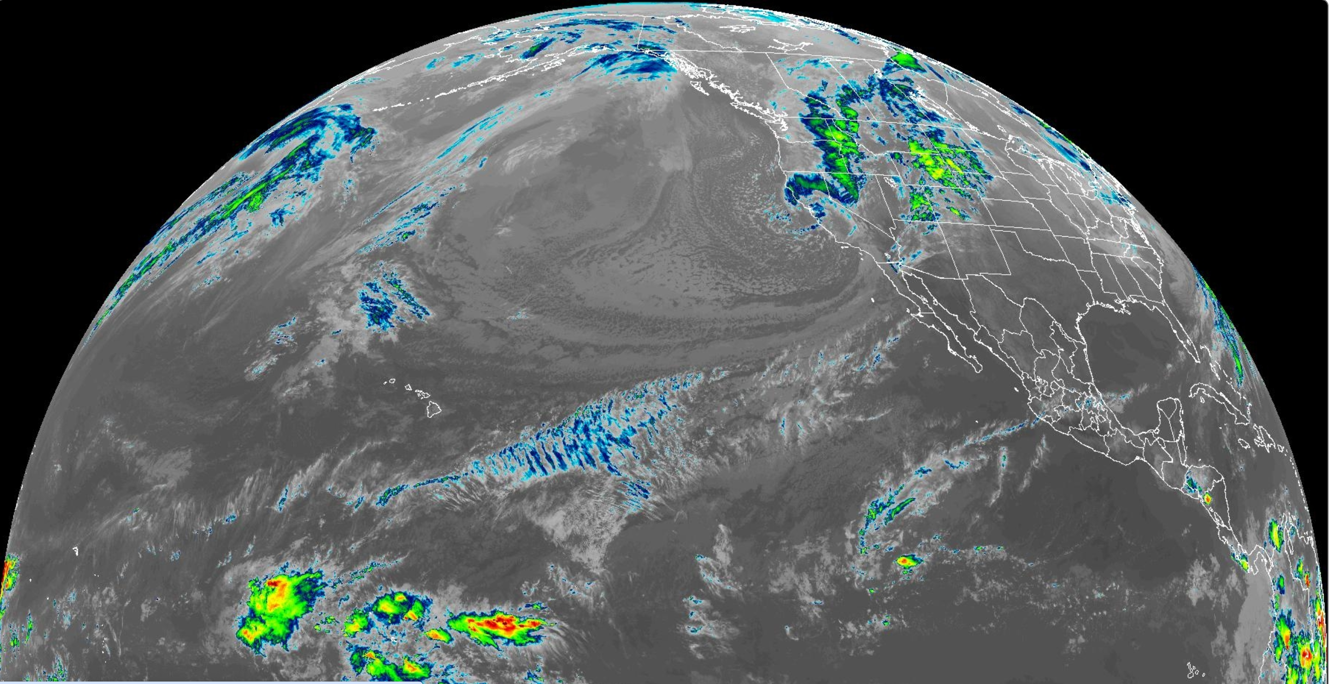
Not much surf this week (or sun for that matter) as low pressure systems to our N are bringing just enough clouds to squeeze out some drizzle but not strong enough to kick up some surf. For tomorrow though, another cold front will swing by to the N of us but this time it will kick up some NW windswell. Look for a breezy day tomorrow and surf in the chest high range with head high sets late. On Saturday, the NW windswell starts to wind down while the wind backs off too. We'll also have a touch of small SW to break up the NW for fun chest high surf. Sunday looks to be the same. And here’s the sun, tides, and water temps for the upcoming weekend:
- Sunrise and sunset:
- 6:05 AM sunrise
- 7:28 PM sunset

- Water temps are low 60's in SD and high 50's in LA.

- And not much change in tides this weekend:
- just under 0' at sunset
- and only up to 2.5' in mid-afternoon
FORECAST:
For next week, there's not much on the charts. Looks like some waist high combo SW/NW.

Our next shot of good surf may not be until the week of May 6th as a storm is forecasted to form this weekend off Antarctica and we could see shoulder high waves in about 10 days. But until then- we wait. If anything changes between now and then, make sure to follow North County Surf on X (Twitter).
WEATHER:

As mentioned above, looks like 1 last (?) cold front will sweep through tomorrow. It's not really a rainmaker but we'll have a chance of showers tomorrow morning and winds in the 15 mph+ range. After that, we have sun for the weekend and low clouds in the nights/morning and afternoon sunshine next week. Here's what we have on tap for the next several days:
- Friday: Chance of showers in the AM then sun and breezy. Temps 62/55.
- Saturday: Sunny and nice. Temps 64/53.
- Sunday: Lots of sun and warmer. Temps 67/55.
- Monday and beyond: Morning low clouds and afternoon sun. Temps 68/55
BEST BET:
- Saturday with dropping NW, a touch of SW, and cleanish conditions
- Sunday with small NW and small SW BUT... clean conditions
- Maybe Monday the 6th with good SW if you can wait that long...
NEWS OF THE WEEK:

Before wave pools were fashionable, artificial reefs were all the rage. But the ocean is a fickle beast and getting artificial reefs working as a wave magnet or habitat for fish was tricky at best AND expensive. Engineers at MIT though have designed an 'architected' reef that can mimic the wave-buffering effects of natural reefs while providing pockets for marine life. The sustainable and cost-saving structure could dissipate more than 95 percent of incoming wave energy using a small fraction of the material normally needed. Here's their report:
The beautiful, gnarled, nooked-and-crannied reefs that surround tropical islands serve as a marine refuge and natural buffer against stormy seas. But as the effects of climate change bleach and break down coral reefs around the world, and extreme weather events become more common, coastal communities are left increasingly vulnerable to frequent flooding and erosion. An MIT team is now hoping to fortify coastlines with "architected" reefs -- sustainable, offshore structures engineered to mimic the wave-buffering effects of natural reefs while also providing pockets for fish and other marine life.
The team's reef design centers on a cylindrical structure surrounded by four rudder-like slats. The engineers found that when this structure stands up against a wave, it efficiently breaks the wave into turbulent jets that ultimately dissipate most of the wave's total energy. The team has calculated that the new design could reduce as much wave energy as existing artificial reefs, using 10 times less material.
The researchers plan to fabricate each cylindrical structure from sustainable cement, which they would mold in a pattern of "voxels" that could be automatically assembled, and would provide pockets for fish to explore and other marine life to settle in. The cylinders could be connected to form a long, semipermeable wall, which the engineers could erect along a coastline, about half a mile from shore. Based on the team's initial experiments with lab-scale prototypes, the architected reef could reduce the energy of incoming waves by more than 95 percent. "This would be like a long wave-breaker," says Michael Triantafyllou, the Henry L. and Grace Doherty Professor in Ocean Science and Engineering in the Department of Mechanical Engineering. "If waves are 6 meters high coming toward this reef structure, they would be ultimately less than a meter high on the other side. So, this kills the impact of the waves, which could prevent erosion and flooding."
Details of the architected reef design are reported today in a study appearing in the open-access journal PNAS Nexus. Triantafyllou's MIT co-authors are Edvard Ronglan SM '23; graduate students Alfonso Parra Rubio, Jose del Auila Ferrandis, and Erik Strand; research scientists Patricia Maria Stathatou and Carolina Bastidas; and Professor Neil Gershenfeld, director of the Center for Bits and Atoms; along with Alexis Oliveira Da Silva at the Polytechnic Institute of Paris, Dixia Fan of Westlake University, and Jeffrey Gair Jr. of Scinetics, Inc.

Leveraging turbulence
Some regions have already erected artificial reefs to protect their coastlines from encroaching storms. These structures are typically sunken ships, retired oil and gas platforms, and even assembled configurations of concrete, metal, tires, and stones. However, there's variability in the types of artificial reefs that are currently in place, and no standard for engineering such structures. What's more, the designs that are deployed tend to have a low wave dissipation per unit volume of material used. That is, it takes a huge amount of material to break enough wave energy to adequately protect coastal communities.
The MIT team instead looked for ways to engineer an artificial reef that would efficiently dissipate wave energy with less material, while also providing a refuge for fish living along any vulnerable coast. "Remember, natural coral reefs are only found in tropical waters," says Triantafyllou, who is director of the MIT Sea Grant. "We cannot have these reefs, for instance, in Massachusetts. But architected reefs don't depend on temperature, so they can be placed in any water, to protect more coastal areas."
The new effort is the result of a collaboration between researchers in MIT Sea Grant, who developed the reef structure's hydrodynamic design, and researchers at the Center for Bits and Atoms (CBA), who worked to make the structure modular and easy to fabricate on location. The team's architected reef design grew out of two seemingly unrelated problems. CBA researchers were developing ultralight cellular structures for the aerospace industry, while Sea Grant researchers were assessing the performance of blowout preventers in offshore oil structures -- cylindrical valves that are used to seal off oil and gas wells and prevent them from leaking. The team's tests showed that the structure's cylindrical arrangement generated a high amount of drag. In other words, the structure appeared to be especially efficient in dissipating high-force flows of oil and gas. They wondered: Could the same arrangement dissipate another type of flow, in ocean waves?
The researchers began to play with the general structure in simulations of water flow, tweaking its dimensions and adding certain elements to see whether and how waves changed as they crashed against each simulated design. This iterative process ultimately landed on an optimized geometry: a vertical cylinder flanked by four long slats, each attached to the cylinder in a way that leaves space for water to flow through the resulting structure. They found this setup essentially breaks up any incoming wave energy, causing parts of the wave-induced flow to spiral to the sides rather than crashing ahead. "We're leveraging this turbulence and these powerful jets to ultimately dissipate wave energy," Ferrandis says.
Standing up to storms
Once the researchers identified an optimal wave-dissipating structure, they fabricated a laboratory-scale version of an architected reef made from a series of the cylindrical structures, which they 3D-printed from plastic. Each test cylinder measured about 1 foot wide and 4 feet tall. They assembled a number of cylinders, each spaced about a foot apart, to form a fence-like structure, which they then lowered into a wave tank at MIT. They then generated waves of various heights and measured them before and after passing through the architected reef. "We saw the waves reduce substantially, as the reef destroyed their energy," Triantafyllou says. The team has also looked into making the structures more porous, and friendly to fish. They found that, rather than making each structure from a solid slab of plastic, they could use a more affordable and sustainable type of cement. "We've worked with biologists to test the cement we intend to use, and it's benign to fish, and ready to go," he adds.
They identified an ideal pattern of "voxels," or microstructures, that cement could be molded into, in order to fabricate the reefs while creating pockets in which fish could live. This voxel geometry resembles individual egg cartons, stacked end to end, and appears to not affect the structure's overall wave-dissipating power. "These voxels still maintain a big drag while allowing fish to move inside," Ferrandis says.
The team is currently fabricating cement voxel structures and assembling them into a lab-scale architected reef, which they will test under various wave conditions. They envision that the voxel design could be modular, and scalable to any desired size, and easy to transport and install in various offshore locations. "Now we're simulating actual sea patterns, and testing how these models will perform when we eventually have to deploy them," says Anjali Sinha, a graduate student at MIT who recently joined the group.
Going forward, the team hopes to work with beach towns in Massachusetts to test the structures on a pilot scale. "These test structures would not be small," Triantafyllou emphasizes. "They would be about a mile long, and about 5 meters tall, and would cost something like 6 million dollars per mile. So it's not cheap. But it could prevent billions of dollars in storm damage. And with climate change, protecting the coasts will become a big issue."
BEST OF THE BLOG:
SURF MEETING TOMORROW, FRIDAY THE 26TH IS POSTPONED!
As luck would have it, cold fronts don't know to stay north this time of year and we're due for wind and showers tomorrow morning. So we need to postpone Friday's Surf Meeting. BUT... all systems are GO for...

Our 9th annual charity golf tournament- sponsored by Venture LLP! We'll be at Goat Hill on Friday, May 17th would would like you to join us but WE ARE ALMOST SOLD OUT! This year we'll be benefitting Foster the Earth, an organization dedicated to helping vulnerable children and young adults in the foster care system through exposure to the great outdoors. Cost is just $150 to play (and includes lunch from our friends at Senor Grubby's) and hole sponsorships are $250. It's first come, first serve- so if you haven't signed up yet, give a shout this weekend to northcountyboardmeeting@gmail.com or rich@logicopy.com to reserve your spot.
And if you can't make it, we do have a couple spots left for hole sponsorships to market your company and are always in need of auction/raffle items. So if you're looking to give back to your community and Foster the Earth- let me know if you have something you'd like to donate or sponsor. Thank you in advance for your support!
PIC OF THE WEEK:

Oldie but a goodie from the 1920's. As you may or may not know, the Santa Ana River currently separates the cities of Huntington Beach and Newport Beach. But before the 1920's, the mouth of the river flowed out through Newport Harbor and into the sea at Corona del Mar instead. It was considered one of the best waves in California due to the deepwater sandbar picking up loads of surf and the long rides. But alas money won out and the jetties were built in the late 1920's/early 1930's to make way for the yachts (just proving my theory once again that Thurston Howell III did not surf). Every cloud has a silver lining though as one of the jetties resulted in the world famous Wedge. So all is not lost. To learn more about these unique waves, check out my story here.
Keep Surfing,
Michael W. Glenn
Meteoric Rise
Mr. Irrelevant
I'm Old School; Still Use Paraffin Wax And Wear A Wool Sweater Out At Rincon
Michael W. Glenn
Meteoric Rise
Mr. Irrelevant
I'm Old School; Still Use Paraffin Wax And Wear A Wool Sweater Out At Rincon