Friday, March 29, 2013

THE Surf Report


Out like a lion and in like a lamb.

SURF:
Some pretty darn fine surf last weekend. The combo swells lit up most beaches and the weather cooperated by Sunday too.
Ever since then the SW and NW swells have been on a slow decline and today there's just small leftovers for waist high sets at best S facing spots- mainly in the OC. It doesn't get much better tomorrow as we have to wait for our next swell to arrive on Sunday afternoon. Currently there's a storm sitting off our coast and it's in a unique spot- just due W and will go a little S of us tomorrow. This storm a few days ago came down from the Aleutians and went parallel to our coast- so the swell angle will almost seem like a short interval SW. We had something like that last winter and made for some fun waves due to the unique angle. Look for chest high waves most everywhere late Sunday into Monday. There may be a little S wind bump though from it and light showers late Sunday so pick your spot wisely. At least the light S wind lately has bumped the water temps above 60 finally!
Tides the next few days are 0' at sunrise, about 4' at 11am and around 0' at sunset. Make sure to keep up to date on the waves/weather at Twitter/North County Surf!

FORECAST:

The unique WSW swell on Sunday evening spills into Monday and is joined by a new shoulder high SW. The showers hopefully will taper off by then and that new SW swell lasts into Tuesday. On it's heels is another SW for chest high+ waves filling in Thursday. And after that we have a new WNW on the charts that should fill in next Saturday- but maybe some light showers again though- but that's a long way off.
And there's little storms forecasted to flare up in the southern hemisphere on Monday that may give us some chest high sets late next Sunday.

WEATHER:

In regards to that unique storm sitting off our coast, charts last week had that thing slamming into us with a ton of rain. That's not the case anymore as it just continues to move parallel to us and we'll only get a glancing blow with light showers Sunday evening into Monday. Best case is 1/4" of rain, light S wind, and cloudy skies. Looks like nice weather is lining up though Tuesday to Thursday next week with temps in the mid to high 60's and clear skies. Models then show another weak storm trying to take aim at us towards Friday but I'm not fretting about it since the charts have been off lately and winter is officially over.

BEST BET:
Hard to say- that unique WSW swell angle may be fun late Sunday but we may have some light S wind and showers. So probably next Thursday with the new SW swell and nice weather.

NEWS OF THE WEEK:

Seems like over the past few years storms have been gettin’ meaner. Have you noticed around here it’s been either all or nothing for us? We get a big storm or we get nothing at all- there’s no in-between. There's little doubt -- among scientists that is -- that the climate has warmed since people began to release massive amounts of greenhouse gases to the atmosphere during the Industrial Revolution. But ask a scientist if the weather is getting stormier as the climate warms and you're likely to get a careful response that won't make for a good quote. There's a reason for that. "Although many people have speculated that the weather will get stormier as the climate warms, nobody has done the quantitative analysis needed to show this is indeed happening," says Jonathan Katz, PhD, professor of physics at Washington University in St. Louis. In the March 17 online version of Nature Climate Change, Katz and Thomas Muschinksi, a senior in physics who came to Katz looking for an undergraduate thesis project, describe the results of their analysis of more than 70 years of hourly precipitation data from 13 U.S. sites looking for evidence of increased storminess. They found a significant, steady increase in storminess on the Olympic Peninsula in Washington State, which famously suffers from more or less continuous drizzle, a calm climate that lets storm peaks emerge clearly. "Other sites have always been stormy," Katz says, "so an increase such as we saw in the Olympic Peninsula data would not have been detectable in their data." They may also be getting stormier, he says, but so far they're doing it under cover.  "We didn't want to know whether the rainfall had increased or decreased," Katz says, "but rather whether it was concentrated in violent storm events.  "Studies that look at the largest one-day or few-day precipitation totals recorded in a year, or the number of days in which total precipitation is above a threshold, measure whether locations are getting wetter, not whether they're getting stormier, says Katz. To get the statistical power to pick up brief downpours rather than total precipitation, Muschinski and Katz needed to find a large, fine-grained dataset. "So we poked around," Katz says, "and we found what we were looking for in the National Oceanic and Atmospheric Administration databases." NOAA has hourly precipitation data going back to 1940 or even further for many locations in the United States. Muschniski and Katz chose 13 sites that had long runs of data and represented a broad range of climates, from desert to rain forest. They then tested the hypothesis that storms are becoming more frequent and intense by taking different measurements of the "shape" formed by the data points for each site. Measuring these "moments" as they're called, is a statistical test commonly used in science, says Katz, but one that hasn't been applied to this problem before. "We found a significant steady increase in stormy activity on the Olympic Peninsula," Katz says. "We know that is real." "We found no evidence for an increase in storminess at the other 12 sites," he said, "but because their weather is intrinsically stormier, it would be more difficult to detect a trend like that at the Olympic Peninsula even if it were occurring." The next step, Katz says, is to look at a much larger number of sites that might be regionally averaged to reveal trends too slow to be significant for one site. "There are larger databases," he says, "but they're also harder to sift through. Any one site might have half a million hourly measurements over the period we're looking at, and to get good results.  We have to devise an algorithm tuned to the database to filter out spurious or corrupted data." What does all this mean? The hunch seems correct storms are a little stronger and there’s a lot of work to be done to sift through all that data for a conclusion- hopefully we have an answer before we get more storms like Sandy.

BEST OF THE BLOG:

Rip Curl is all over the place lately- from the award winning F Bomb fullsuits this winter to the Bells contest going on this week to new stores popping up- like the one across the street from Swami's? Doesn't mean I have to go to Trestles anymore! Well to surf Lowers of course. Check out the story on the North County Surf blog. And of course a mid-week Surf Check AND an in-depth THE Surf Report; all of that and more in the blog below!

PIC OF THE WEEK:

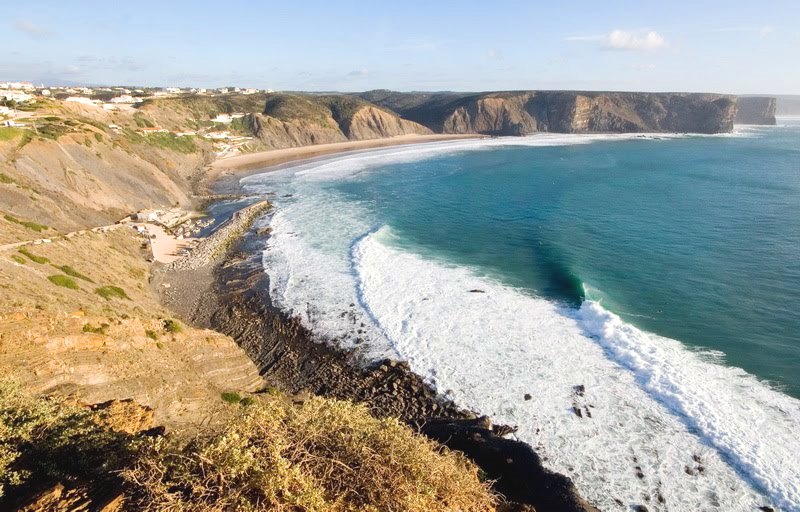
Is it good or is it bad? Looks fast, breaking over a shallow shelf, pretty meaty, and a solid barrel. That's the good- not the bad of course. The bad? No one out to share it with. I guess that's good too.

Keep Surfing,

Michael W. Glenn
High Roller
UFOlogist
Discovered a New Spot Just North of Tijuana Sloughs and South of Fort Point

Thursday, March 28, 2013

North County New Business News: Torquay To Trestles to... Swami's?!


Seems like Rip Curl is all over the place nowadays. From their award winning F Bomb fullsuits and Mirage boardshorts, to the Bells Easter Classic going on this week in Torquay, Australia, to new stores popping up- you can't turn your head and not bump into Sir Ripley J. Curl. Considering not everyone is out of the recession yet, it’s good to see companies making an effort to turn things around. Like the new Rip Curl surf shop next door to Hansen's in downtown Encinitas. It was unfortunate to see Leucadia Surf Shop, Becker, and K5 close their doors recently but on it’s heels is the surf company Rip Curl founded in 1969 and their new collaboration with Hansen's.
It’s an interesting building that’s been there for at least 50 years- just north of Swami's on highway 101. It was originally a gas station, then went through various reincarnations that included a real wood furniture store and most recently was Hansen’s staging area for their internet sales. What's particularly interesting about this shop is that the shop employees told me it's a collaboration between Rip Curl and Hansen's; Hansen's still owns the building but Rip Curl filled it with product. Not a bad deal.
In what seemed like the span of a few days, they repainted the place, added some signs, threw in fresh carpet, wheeled in fixtures, and added more wetsuits, boardshorts, tees, and hats than you can shake a stick at. Speaking of sticks- they won't have boards in their for a few more days. Regardless, the place looks killer. Unfortunately I just bought 4 new Rip Curl suits this winter so I'm dialed for now, but I'll have to grab a fresh pair of boardies for summer I guess.
 
Rumor has it they're going to have an official grand opening soon (last week was their 'soft opening') and they'll probably have a bbq, giveaways, music, whatever, but in the meantime, don't wait- get there while the selection is still good. Like those red, white, and blue Wilko fullsuits you've been dying to rock at D Street. They've got the same hours as the Hansen's store too:
  • Monday and Tuesday 9am to 6pm
  • Wednesday, Thursday, and Friday 9am to 9pm
  • Friday and Saturday 9am to 6pm
  • Sunday 10am to 5pm
Make sure to check back on the North County Surf blog for the official grand opening party info.


Tuesday, March 26, 2013

Surf Check


Dreamy little day out there today. Nothing like the solid surf we had over the weekend but there's still some fun chest high sets in far north county SD/OC from the SW with a touch of NW. You'd think it was summer out there with the great conditions except the water is only 60 degrees.
Tides this morning were 5’ at 9am, around 0’ at 3pm today, and back up to 4’ at sunset.
Unfortunately we don’t have much surf coming our way the next few days and the weather will be a little cloudier tomorrow but high pressure builds back in Thursday/Friday and it should stay nice with hazy afternoon sunshine. Look for small waist high sets from the SW until Sunday. Charts are actually showing a weak storm coming through late Saturday into Sunday for a chance of light showers but Monday afternoon we should be back to normal. Just in time for our next swells.
We have a small NW showing up for chest high sets in SD on Monday.
Also filling in is a SW swell that formed a couple days ago and we should have shoulder high sets in north county SD and overhead sets in the OC. Another storm formed on it’s heels and we’ll have head high sets towards Wednesday and overhead sets again in the OC. That lasts into Friday. All in all it looks pretty fun Monday to Friday next week but we’ll have to be content with small surf until then. And in the very far future, charts are showing another NW forming off Japan in a few days- hopefully we'll have another fun NW next weekend.

Friday, March 22, 2013

THE Surf Report


March Madness.

SURF:
Not much surf this past week. Just some little SW/NW background swells but we started to see the signs of some new NW and SW last night.
This morning we have some shoulder high sets from a short period NW swell while the SW continues to build. The OC and south SD have some head high sets and most spots are peaky due to the combo swells. Be aware though of the S wind from the fog. For the weekend, looks like we have more good surf on tap as the NW starts to back off tomorrow but the SW is reinforced by a solid storm we've been watching this past week. Spots around town will have head high sets while the OC will have overhead sets. As the NW winds down tomorrow, spots in south SD will be a little smaller. Still plenty of fun waves though. Sunday morning looks to be about the same. Long story short- a good weekend for surf.
Water temps are inching up to 58 and tides are pretty defined the next few days- about 5' at sunrise, 0' at lunch, and back up to 4' at sunset. Make sure to keep up to date on the waves/weather at Twitter/North County Surf. 

FORECAST:

After a good weekend of surf, the ocean takes a little breather as there are no major SW or NW swells headed our way. We may get a little bump from the NW towards the end of next week but nothing exciting.
As far as the southern hemisphere goes, the charts looked pretty dead the past few days but as of this morning, they're showing another good storm forming around the 27th. If that holds up, we should get good head high surf again towards April 3rd.

WEATHER:

Models can't agree 100% on the short term but we should have some nice weather this weekend. Just depends on what the low clouds will do in the mornings and evenings and if there's a little morning sickness with S wind from the fog. Nothing too thick but will it clear up early or hang around until lunch? That's the question pretty much all the way until next Thursday with temps in the mid-60's. Charts then show the jet stream taking a dip our way and sending a storm to our region by Friday. We need it since we're only around 1/2 our normal rainfall right now.

BEST BET:
Saturday is the day. No work, peaking NW windswell with SW groundswell, and nice weather. Oh lordy. 

NEWS OF THE WEEK:

There's been a lot of talk lately about the discovery of the Higgs boson or the 'God Particle' and how it's the building block of the universe. But in our surf universe, I could care less. I want to get down to the nitty gritty and discuss what the building block of surf is. Sure storms make surf, but what is the building block of a storm? Wind of course. But what makes wind? Wind is caused by differences in atmospheric pressure created, in large part, by the unequal heating of the earth's surface by the sun. Air moves from a region of higher pressure to one of lower pressure and this movement is wind. Any difference in pressure will cause wind, but the greater the difference the stronger the wind. The direction that wind takes is influenced by the rotation of the earth. On a non-rotating earth wind would move in a straight path from a high- to a low-pressure area. It is deflected from this path—to the right in the Northern Hemisphere and to the left in the Southern—by the turning of the earth on its axis. Local winds—those that affect a comparatively small area—are often caused by heat transferred by convection. Direct radiation from the sun does little to heat the air. It is warmed chiefly by heat radiated from the earth. Intense local heating of the land causes air directly above to become greatly heated and to expand. As a result, some of the air aloft flows away, lowering the pressure over the heated area and increasing the pressure around it. The cooler, heavier air near the earth then flows to the heated area. In mountainous areas, winds tend to blow uphill during the day because the mountainside is heated more than the valley below it. At night, when the mountainside cools, the wind blows downhill. In summer, breezes tend to blow from oceans or large lakes to the warmer land during the day. They blow from the land at night- offshore- when the land cools. That's why the dawn patrols are so darn good.

BEST OF THE BLOG:

The pros have been busy 'working' this past month while surfing the Gold Coast contest and now prepping for the Bells event. So we're left with a smorgasbord of videos on the web the past few weeks as they don't have 'time' to make a proper clip as they 'work'. Videos like Reef's new film starring Mick Fanning, Craig Anderson surfing some dreamy little beach break barrels, and a tune up contest at Margaret River. Just enough to whet anyone's appetite for our upcoming surf this weekend. Check out the footage on the North County Surf blog. And of course a mid-week Surf Check AND an in-depth THE Surf Report; all of that and more in the blog below!

PIC OF THE WEEK:

There are so many good places to surf in Indo. And it seems like new places are found every year. Wasn't G-Land the place to go in the not too distant past? Then Padang, then Lance's Right, Macaroni's, and countless more. Now Keramas is the flavor of the month. Well today's Pic of the Week is another Indo barrel that's been forgotten about. Someone lucky is going to stumble upon it again in the near future.

Keep Surfing,

Michael W. Glenn
Captain
Perfect Bracket
Collaborating on a new Film With Bruce Brown and Runman

Thursday, March 21, 2013

Clips of the Day: $2 You Call Its


Since the pros are back on tour, most of the clips the past month have been of a random variety- new movie traliers, highlights from a recent contest, and some dreamy little beachbreak barrels. I've decided to put all of them on the North County Surf blog this week- kind of a surf jambalaya. First up is Reef's new video above called 'Anything Sing' which bridges old school and new with Nick Rozsa, Shane Dorian, Conner Coffin, Mick Fanning, and more. Basically I'm looking forward to the White Lightening and Backdoorian footage.
Another good clip is from Marine Layer Productions or Summer Teeth or whatever Dane Reynolds is calling his site now. In typical Dane fashion, the surf isn't firing or particularly big but rather some random beachbreak with no one out. What's different about this clip vs. all the other clips he puts out is that it mainly features pal Craig Anderson and it's not windy but glassy. But it looks so darn fun- just waist to chest high, no one out, and perfect little barrels. The clip can be viewed here.
And the pros are in-between WCT events right now (Gold Coast and Bells) so they've made a little stopover in Western Australia to surf Margaret River. And surf a Prime event in the process- the Drug Aware Pro. And in typical Margaret's fashion- it's firing. Yesterday was a solid 8' and offshore. 'CT guys were out shredding, 'QS guys were ripping, and there was even an Occy sighting. And lucky for us- Pottz is commentating. Pottz even said that if the swell keeps building, by Saturday they'll be having he finals at The Box. No bull. Make sure to check out the event here. In-between March Madness viewing of course.

Tuesday, March 19, 2013

Surf Check


Looks like things are starting to shape up for us later this week. But before we get to the good stuff, let's talk about the near term.
Today we have some small SW groundswell with a touch of tiny NW windswell for waist high waves around town and some chest high sets towards the OC. Skies are mostly sunny with high clouds and the wind is W at 10. Typical Southern California late winter.
We have a weak disturbance moving through tomorrow night and it may squeeze out some sprinkles but that's about it. By Friday it starts to clear out and the weekend should be sunny with temps in the mid-60's. Pretty darn nice for the first weekend of spring.
Tides the next few days are about 3' at sunrise, down to 0' at lunch, and back up slightly to 3.5' at sunset. Water temps are still 58 degrees- not time for the springuit yet.
So what's going on with the surf later this week? Well it looks kind of small tomorrow but we should have some NW and SW swells headed our way for Thursday through the weekend. First up is the weak cold front moving through tomorrow night. In it's wake it will kick up some NW windswell for us Thursday-Saturday. Best spots in SD will see some chest high waves from it.

And if you've been reading the North County Surf blog lately, you probably saw the solid storm forming off Antarctica about a week ago. That swell is headed our way and we should see some waves filling late Thursday from it and peaking Saturday morning. This looks to be good for shoulder high+ waves here in north county SD and overhead sets in the OC. And as luck would have it, we have clearing skies late Friday for a nice weekend weather-wise AND that NW windswell to cross up the SW lines. There- I jinxed it- the curse of the combo swell. Anyway, if everything holds up, we should have some good surf late Thursday into Sunday morning with nice weather to boot.
And of course all good things must come to an end- the southern and northern Pacific look pretty dormant after the 2 swells mentioned above so it should be pretty small around here next week. But why think ahead? Live in the now and enjoy some good surf this weekend. Let that lawn grow an extra foot and forget taking out the trash for a few days!

Friday, March 15, 2013

THE Surf Report


FUgly = Foggy + Ugly

SURF:

Kind of a bummer week of surf. We had good surf on Sunday to start the week then everything went downhill from there- just small knee high NW windswell mixed with small knee high SW swell. Best combo spots had surf in the waist high+. And if that wasn’t enough, inland was 80 degrees while the beaches were socked in with fog and temps in the low 60’s. Wasn’t really a motivating factor to get out there and rip! Today is marginally better as we have a slight uptick in the SW swell and the small NW should pick up more tomorrow. Most spots everywhere today are waist high+. The low clouds/fog will also stick around all weekend.
For tomorrow look for the NW to pick up some more and the SW to peak. Best spots should have inconsistent chest high sets. For Sunday the SW will hang around and the NW windswell will pick up again slightly for consistent chest high sets. Nothing big this weekend but the beachbreaks may have some small fun combo peaks. Water temps are inching up to 58 and tides the next few days are 1' at sunrise, up to 3.5' at lunch, and down to 1' again at sunset. Make sure to keep up to date on the waves/weather at Twitter/North County Surf.

FORECAST:

After a little weekend of waves, the NW starts to back off on Monday and looks pretty small from that region next week. Maybe we'll get a little NW windswell towards next weekend but it's not looking too exciting. The southern hemisphere though is really starting to come to life- just in time for spring.
Charts had a good little storm form a few days ago and we should get a chest high swell in north SD county towards Tuesday with the OC getting some shoulder high sets. That storm is now reforming and trying to make itself into a solid swell maker with seas at the center around 40'. If everything holds together, we should get head high+ waves for north SD county around the 22nd with sets overhead+ in the OC. Keep your fingers crossed. After that the southern hemisphere takes a breather. 

WEATHER:

Did I ever tell you how much I hate fog? I like great sunny beach weather or stormy as hell. Fog falls somewhere in-between and is a real downer. Unfortunately, that's the forecast for the next 5 days- low clouds and fog and probably not breaking up at the beaches. Temps will be in the low 60's too. Models hint at rain moving in towards Wednesday evening so I'm hoping the forecast holds up!

BEST BET:
If that storm in the southern hemisphere holds together, and the rain ends by Thursday, then next Friday should be good...

NEWS OF THE WEEK:

What's going on in the world of weather? Let's take a look back at some recent history as well as some odd events...

•The combined average temperature over global land and ocean surfaces for February 2013 tied with 2003 as the ninth warmest on record, at 1.03°F above the 20th century average of 53.9°F.

•The global land surface temperature was 1.80°F above the 20th century average of 37.8°F, tying with 2010 as the 11th warmest February on record. For the ocean, the February global sea surface temperature was 0.76°F above the 20th century average of 60.6°F, making it the eighth warmest February on record.

•The combined global land and ocean average surface temperature for the December–February period was 0.92°F above the 20th century average of 53.8°F, making it the 12th warmest such period on record.

•The December–February worldwide land surface temperature was 1.28°F above the 20th century average, tying with 1992 as the 15th warmest such period on record. The global ocean surface temperature for the same period was 0.77°F above the 20th century average and was the eighth warmest such period on record.

•The combined global land and ocean average surface temperature for the January–February period (year-to-date) was 1.01°F above the 20th century average of 53.8°F, tying with 2005 as the ninth warmest such period on record.

2008: A funnel cloud was observed southwest of Balboa Park just east of Downtown San Diego

1987: Widespread strong storm winds pushed gusts to 40 mph at San Diego. Power outages occurred all over the San Diego metro area. Motor homes toppled in the desert. Boats flipped over in harbors. Catalina cruise ships were delayed, stranding 1,200 tourists there.

1986: Heavy rain and snow that started on this day and ended on 3/16 caused mud slides along the coast in Orange County. Three feet of snow fell in the San Bernardino Mountains.

1905: 0.94 inch fell in San Diego in 30 minutes, the greatest 30 minute rainfall on record.

BEST OF THE BLOG:

More signs the recession is over- or at least businesses are betting on the near future- more housing developments in north county SD. Looks like that massive lot in NW Leucadia (about a block south of Ponto and a block north of the little skate park) is finally being built. Almost 10 years in the making. Check out the details on the North County Surf blog. And of course a mid-week Surf Check AND an in-depth THE Surf Report; all of that and more in the blog below!

PIC OF THE WEEK:

Just another random point in the Canary Islands. Eureka!

Keep Surfing,

Michael W. Glenn
Player Hater
Working for Free at the TSA 'Cause I Love to Frisk
The 'G' in G-Land Stands For Glenn

Wednesday, March 13, 2013

North County New Business News: A Place For Spock To Call Home


If you've followed the North County Surf blog over the years, you've probably noticed one of the longest running stories (October 2011 and August 2012) is that of the big vacant lot on the corner of Vulcan and Ashbury. This tract of land that fronts Vulcan in the NW corner of Leucadia seems like it's been vacant for at least a decade.
I know it's been that way for at least 6 years because the foreman I talked to today on-site says he's been waiting that long to start this project. I seriously hope he worked on other projects in the meantime. So what's the scoop with this development?
Looks like Shea Homes is building 69 homes on the property with 37 being single family houses and 32 being multi-family. They are aiming to have a model home open in April.
Kind of reminds me of the homes over at the Leucadia Oaks Park (minus the multi family homes). The land is about the same size, they're both on Vulcan, and they're about a block from each other. If it's any indication, these new single family homes from Shea may be around the same price as the Leucadia Oaks Park homes- probably starting in the $900's and the multi family homes in the $750's.
Another Shea Homes development that looks fairly interesting is their 'V Homes' project- about a block north from their other big project on Vulcan mentioned above. They're 5 townhomes all roughly 1900 square feet. The former building was an older apartment complex so it's nice to see a fresh look to this location. They are also across the tracks from Grandview beach and a short bike ride to Ponto. Not a bad location.
Looks like the townhomes are going to start in the $600's and if the pace of construction is any indication, they should be move-in ready by summer. Make sure to take a look at the model when it's open this spring.