Thursday, November 21, 2019

THE Surf Report- Early Edition


Life is funny sometimes. 

SURF:
For MONTHS there were no waves or weather to get excited about. Now there's too much to fit into one email. But I'm going to try. So here goes: 


Last weekend we had fun NW/SW swells for shoulder high sets and that slowly tapered off during the week. On Tuesday night, our first real storm of the season rolled into town and all heck broke loose with an inch of rain and 8' stormsurf. Today was cleaner (wind-wise) but the water was filthy. Best bet this weekend is to stay out of the surf until at least Sunday. 


BUT... we have a fun chest high+ NW headed our way on Saturday- so take your chances. Sunday the new swell drops slightly but we'll have great weather. Water temps are in the low 60's and here's what going on with the tides and sun this weekend:
  • Sunrise and sunset are:
    • 6:25 AM
    • 4:45 PM
  • And tides this weekend are:
    • 6' at sunrise
    • 0' after lunch
    • 3' at sunset
FORECAST:
Monday starts off slow with nice weather and waist high NW. 


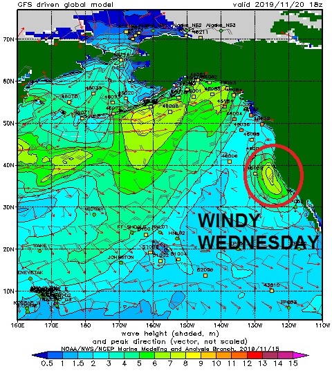
The storm track seems to be active in the near future so we start to see new chest high NW arrive on Tuesday with our last good day of weather. On Wednesday the rain returns along with building head high NW. That lasts into Gobble Gobble day. 


Next weekend should clean up with chest high surf and if the models are correct- more good NW around the 1st- if the weather cooperates too. Make sure to check out Twitter/North County Surf if anything changes between now and then. 

BEST BET: 
Saturday with fun NW and great weather or Tuesday afternoon with new NW and the last of the good weather. 

WEATHER:


Not a bad way to start our rainy season. 1" of rain along the coast of SD, 4" in the local mountains, and Big Bear received 1/2 a foot of snow. This weekend high pressure is in control with clear cool skies. Early in the week looks nice still, then as mentioned above, we're due for another good storm Wednesday through Friday possibly. Since we're only at 30% of normal for our rainfall so far this season, it's a blessing- even though it's screwing up the surf. 

NEWS OF THE WEEK:


As reported in last week's THE Surf Report, we've got a mysteriously large blob of warm water off the coast of the western US. Scientists can't pinpoint the exact reason for the warming but it may be due in part to Global Warming. Each year, as humans emit billions of metric tons of CO2 into the atmosphere, nearly a third of the emissions ends up in the ocean, changing the chemical balance of the water. And as the climate changes, the ocean is also absorbing almost all of the Earth’s extra heat, melting ice that creates sea level rise, making the water uninhabitable for marine life, and changing the planet’s weather patterns. A new report from the IPCC, the UN panel that studies climate change, lays out exactly what’s at stake for the ocean as a result—and for humans, all of whom rely on the ocean either directly or indirectly. Here's what Fast Company magazine reported recently:

“What comes out of this report is that it’s going to hit us in so many ways,” says Mark Spalding, senior marine scientist for The Nature Conservancy, one of the organizations that contributed to the report. The litany of potential disasters from a changing ocean is horrifying: As the warming water melts ice sheets in Greenland and Antarctica, the sea level rises each year, putting hundreds of millions of people who live in low-lying coastal areas at risk of flooding. A warmer ocean supercharges hurricanes. Marine heatwaves can boost toxic algae and close fisheries. As the water absorbs CO2, it becomes more acidic, posing another threat to coral reefs. And all these impacts can exacerbate each other—coral reefs, for example, “play the role of a sea wall,” says Spalding. “They sit offshore like a barrier and they break waves before the waves get to land.” As storms get stronger, this natural protection is being lost at the same time.

For marine ecosystems, these threats are piling up on top of other human impacts. “A lot of the other damage we’ve done to habitats is making the threat of climate change worse,” he says. “We overfish, we damage coral reefs, we pollute. This idea that humans are adding to the problem comes out quite clearly in this report. The flip side to that is that we can do something about it. If we can reduce some of these parallel problems, we can at least buy ourselves some time to deal with the climate change piece of this.” The Nature Conservancy, for example, is working on projects to restore coral reefs and other marine ecosystems, as in a project in the Caribbean that created an insurance policy for coral reefs; hotels in the area pay a premium each month so that if a storm hits, the funding can immediately be used to rebuild the reefs to protect the hotels. Other projects are restoring mangroves, a coastal ecosystem that is uniquely good at sucking carbon from the air.

The biggest change that needs to happen, of course, is a move to a zero-carbon economy. “What happens depends on what decisions we make now and in the next few years,” says Spalding. “Do we follow a business-as-usual path? Or do we really knock it down and try to aim for [warming of just] 1.5 degrees?” The difference between limiting global warming to 1.5 degrees Celsius, instead of 2 degrees, might sound small. But it’s actually huge. “It’s startlingly different between one and the other. The lowest emission scenario is still talking about just one meter of sea level rise in a couple of hundred years’ time. With a high-emissions scenario, we’re talking about multiple meters of sea level rise, which frankly is curtains for entire nations—even wealthy nations and cities that are on the coast.”
PIC OF THE WEEK:


The west coast is finally coming to life. Like this gem between San Diego and San Francisco. If you want to know it's exact location though, make sure to head on over to www.secretspots.com and you'll find GPS coordinates, maps, and webcams, all free of charge.  

Keep Surfing, 

Michael W. Glenn
Enduring
Hulkamaniac
My Therapist Says It's Perfectly Fine That I Baby My Surfboards

Thursday, November 14, 2019

THE Surf Report- Early Edition


I'm THIS close to activating the Emergency Boardriding System...

SURF:

Finally some fun surf this week- with pesky afternoon NW winds- but I'll take it considering how small it's been the past 2 months. Early in the week we had fun SW swell and that was met by fun NW yesterday. Best spots had shoulder high sets and it was good to get off the groveller! For tomorrow morning, we have leftover SW/NW with chest high sets but by the afternoon we see signs of a new, good, NW swell. 


By Saturday morning we have head high sets here in north county SD and maybe an overhead set in south SD. And if that's not good enough, we've got a slight Santa Ana this weekend so conditions should be great through mid-morning. Sunday backs off slightly with shoulder high sets and head high waves in SD. Along with great weather again. All in all a fun weekend. Water temps are still in the low to mid-60's and here's what going on with the tides and sun this weekend:

  • Sunrise and sunset are:
    • 6:18 AM
    • 4:47 PM

  • And tides this weekend are:
    • 3' at sunrise
    • 5.5' mid morning
    • 0' at sunset
FORECAST:
Looks like the storm track is finally behaving but the reason I'm not activating the Emergency Boardriding System (EBS) yet is that there's a lot of variables right now. But before I get ahead of myself, let's take a look at early in the upcoming week: Monday will have leftover chest high NW swell and Tuesday starts to pick back up again from the NW with shoulder high sets late in the day. The fly in the ointment? We may have our first chance of showers Tuesday evening into Thursday morning. As that potential storm moves down the coast, the waves/weather will pick up along with it. 


Forecast charts are showing the potential for overhead storm surf on Wednesday. 


There's also some fun chest high late season SW swell headed our way on Wednesday too but the storm will make a mess of it. Thursday will be a transition day with leftover head high NW/SW and next Friday the 22nd may be clean with chest to shoulder high NW. 


And if the models are correct, we may get a solid overhead WNW next weekend. BUT... who knows what the weather will be like now that the storm track looks to be lowering. So now you know my dilema with the EBS- lots of surf coming but conditions may be questionable. Make sure to check out Twitter/North County Surf if anything changes between now and then. 

BEST BET: 
Saturday with fun NW and great weather. Or next Saturday with bigger NW and ??? weather. 

WEATHER:


Looks like the fog/wind is going away as high pressure is setting up shop this weekend. We'll have more sun tomorrow and lots of sun this weekend with temps in the high 70's. And wouldn't you know it, everything gets thrown out the window by Tuesday as the weather models show rain showers by Wednesday and lasting into Thursday. Depending if high pressure builds behind the storm, we could get nice weather next weekend or another shot of rain. I'm hoping for sunny skies of course if that solid swell arrives next Saturday...

NEWS OF THE WEEK:


Remember that weird and unusually warm pool of water off the west coast a few years ago? The one that scientists called 'The Blob' (https://northcountysurf.blogspot.com/2015/05/the-surf-report.html)? Well, IT'S BAAAAACK. Is this thing El Nino related? Is it Global Warming related? Is it Godzilla related?! I'll let the NOAA experts explain:

The Pacific Ocean is throwing a bit of a temper tantrum these days, but it’s not where you think it might be. Often we focus on the tropical Pacific Ocean because it’s where ENSO takes center stage, but currently temperature departures across the Tropics are pretty blah. Instead, for the past few months, it’s the North Pacific Ocean that pops out at you—a gigantic red sore that covers much of the eastern basin.  

The technical term is a Marine Heatwave. Marine heatwaves are considered prolonged, large-scale warm water events. Back in 2014-16, people started calling a very prominent North Pacific marine heatwave THE BLOB. Now, some people are saying this current event could be a return of the Blob. Blob is fun to say and simply rolls off the tongue, so we understand why it’s caught on. 
BUT! The problem is “Blob” is not that useful of a description. There’s no single fixed Blob. It would be like if we called every single hurricane, “Hurricane Dave.” Obviously hurricanes, like marine heatwaves, don’t always occur in the same place, at the same time, have the same magnitude, or even have the same areal coverage. In fact, an El NiƱo can result in conditions that would be considered a marine heatwave in the Tropics, but we would not call that area of warmth a “Blob.”  
Marine heatwaves can be a bit tricky to categorize because, like most phenomena in weather and climate, there are shades of grey. While marine heatwaves can be defined by many different physical properties (e.g. size, intensity, duration), there are no fixed set of impacts that will always result. At this point, it is too early to say if this heatwave might have major impacts on marine life and fisheries the way the last one did.  
The experts at NOAA (Michael Alexander at NOAA Earth Systems Research Lab and Michael Jacox and Nate Mantua, who are with NOAA Southwest Fisheries Science Center) have a lot of great information to share:

Q: So far, how different is the current marine heatwave (Blob Redux) from the one we saw in 2014-16 (The Original Blob)? 

Alexander: Marine heatwaves are usually identified by temperatures at the sea surface, which can be measured by satellites. Based on sea surface temperatures, the general pattern of the current heatwave does resemble the Original Blob.  However, generally, it is important to determine how deep the temperature anomalies (how much warmer or colder the temperature is relative to average) extend into the ocean. As Nate points out below, these anomalies are just near the surface off the US West Coast, so strong storms, which often begin this time of year, can quickly wipe out a heatwave.  In fact, we may have just started seeing this.  
Mantua: The biggest differences so far are in the depth and duration of the two events. The Original Blob lasted for multiple years and the warming eventually extended to more than 300 meters (~1,000 feet) below the surface across much of the Northeast Pacific.  In contrast, the current event has been with us for only a few months, and the extreme warming is confined to the top 30 to 50 meters (~100-150 feet). 


Q: Around the time the marine heatwave emerged in the North Pacific Ocean in 2014, there was an El NiƱo Watch.  How significant is ENSO in helping fuel marine heatwaves (or vice versa)?  

Alexander: The 2014 marine heatwave (Original Blob) started in the northeast Pacific. Recent studies suggest that air-sea interactions allow ocean temperature anomalies near Hawaii to move towards the equator. When warm temperature anomalies, including marine heatwaves, reach the equator they enhance the chance of an El NiƱo event in the following year. So the Blob may have contributed to the strong El Nino event that occurred in 2015-16.
While El NiƱo events occur in the tropical Pacific they influence the ocean and atmosphere in the North Pacific including sea surface temperatures. Generally, the winds are from the southwest near the US West Coast during El NiƱo which warms the underlying ocean, while ocean processes push the deeper cold water farther down, warming a very narrow region right near the coast. A full blown El NiƱo did not happen in 2014 but one did in the following winter, which likely contributed to the continuation of the marine heatwave when it was strongest near the West Coast.
Jacox:  In general, El NiƱo is a very prevalent cause of the marine heatwaves in much of the Pacific. Off the U.S. West Coast, El NiƱo events tend to produce warming by changing the wind patterns that typically cool the coastal ocean, and through an “oceanic teleconnection” where coastal trapped waves propagate northward along the North American west coast. The Original Blob wasn’t caused by El NiƱo, but the tropical warmth during the 2014-15 winter likely helped that heatwave persist and then the strong 2015-16 El NiƱo contributed to the extended warming as well.

Mantua: Georgia Tech Professor Emanuel Di Lorenzo and I published a study showing that the evolution and persistence of the Original Blob involved long-distance teleconnections between the North Pacific and Tropical Pacific that involved two flavors of El Nino. As Mike J. points out, the initial warming off the coast of the Pacific Northwest that first earned the “Blob” label wasn’t caused by El NiƱo. Instead, the atmospheric forcing that started The Blob in winter 2013/14 also contributed to the tropical warming in 2014, which persisted into 2015.  

Q: There are research studies that indicate that that marine heatwaves will become more frequent with climate change. How certain is this?  Could there be a human-caused thumbprint in recent events? 

Alexander: Most of the ocean has warmed over the past 50 years. This warming is projected to continue through the 21stcentury, especially off the northeast US coast. Nearly all computer model simulations of the future indicate the oceans will warm.  So relative to the present, marine heatwaves will become more frequent.  However, if one thinks of a heatwave as a short-term event relative to the mean temperature at that time, the frequency of marine heat could stay about the same but just happen in an overall warmer climate.
Jacox: What those studies show is that in a warming ocean, historical temperature thresholds will be exceeded more often. In other words, temperatures we currently consider extreme will become more common.  But that doesn’t mean marine heatwaves will necessarily change. One could think of it like sea level rise – just because the water gets higher doesn’t mean the waves are getting bigger. How marine heatwaves will change relative to the increasingly warmer temperatures is still an open question, and the answer will likely be different in different parts of the ocean. For marine species, both the warmer temperature and future marine heatwaves will be important. Their relative and combined impacts will vary among species depending on their exposure to warmer temperatures, their sensitivities, and their adaptive capacity.

Q: Perhaps the most important question of all:  If you got the Blob, Polar Vortex, and Godzilla El NiƱo into the ring, which one would win?

Alexander: My dog, which can eat just about anything and drink vast quantities of warm water.
Jacox: Trick question, it turned out that the Blob and Godzilla El NiƱo were on the same team.
Mantua: I’m with Mike and Mike on this one.
PIC OF THE WEEK:


The upside to Global Warming (if there is one)- in 20 year we'll be able to surf this spot in trunks! 

Keep Surfing, 

Michael W. Glenn
Cheeky
People Magazine's Sexiest Man Alive (Runner-Up)
Bought Lopez's House At Pipe So I Could Walk Out The Backdoor And Backdoor The Barrel At Backdoor

Thursday, November 7, 2019

THE Surf Report- Early Edition


Thank you for waiting. 

SURF:


Not much surf this past week but I've got good news and bad news. What do you want to hear first? The good news? Ok, here goes: We've got surf coming! The bad news? It's not that big. Still no major storms in the Pacific is leaving us high and dry (that goes for the rain too). Today we had a small waist high+ NW wind/groundswell that was filling in with MAYBE chest high sets in SD. That will last into Saturday. 


On Sunday we get a little bump from the NW again, this time with chest high sets here in north county SD late in the day and slightly better in southern SD. Water temps are in the low to mid-60's and here's the tides and sun info for ya':
  • Sunrise and sunset are:
    • 6:13 AM
    • 4:51 PM
  • And tides this weekend are:
    • 5' at sunrise
    • 0' after lunch
    • 3' at sunset
FORECAST:


The new boost from the NW on Sunday continues to fill in Monday along with small late season SW. Look for chest high surf on Monday at the best combo spots. Tuesday morning starts off the same and it drops slightly through Thursday morning. 


Further out, models show the potential for shoulder high NW next weekend and head high in SD. The models though have been overselling it the past month so take it with a grain of salt. There may also be small late season SW again around the same time but the potential bigger NW will overide it. Further out, the storm track may start to lower finally, so we could see more fun W swell around the 21st. Make sure to check out Twitter/North County Surf  if anything changes between now and then. 

BEST BET: 
Monday and Tuesday with combo swell or next Saturday if the forecast charts aren't tricking my eyes.

WEATHER:


Still no storms in sight so we're going to have these on again off again mild days. Look for high pressure to build slightly tomorrow for nice weather into Saturday and minimal low clouds/fog. Then the low clouds/fog return Sunday/Monday and then slightly nicer weather for Tuesday/Wednesday. And then... maybe more low clouds/fog later in the week. Not sure what the hold up on the rain is, but we're already 3/4" behind in our rain total for the season. Let's go storms! 

NEWS OF THE WEEK:


We all know how wave pools make waves; there is an energy source that pushes against a body of water and the result is a moving body of water that tumbles on to the shallow end of a pool. But how are ocean waves created? The simple answer is wind? But how does that wind make an actual 50' wave at Mavericks? Let's start at the beginning...

There are 3 factors at play to create waves. 


1. The size of a storm: If a storm is the size of Texas it will make a bigger swell than if a storm is just the size of Delaware.

2. Duration of the wind: If you get a wind gust that lasts a few seconds, you won't see surf from it. But if you get 50 mph winds blowing for 4 days, it will keep building upon the swell it created.

3. Strength of wind. 5 mph winds won't give you enough energy to make good surf- but 150 mph winds sure will.
So how does the wind translate to an actual wave? Waves of course are most commonly caused by wind (or Kelly Slater for $50,000 a day). Wind-driven waves, or surface waves, are created by the friction between wind and surface water. As wind blows across the surface of the ocean or a lake, the constant disturbance creates a wave crest. These types of waves are found globally across the open ocean and along the coast. 

Once waves start to form from the wind, this energy passes through water, causing it to move in a circular motion. However, water does not actually travel in waves. Waves transmit energy, not water, across the ocean and if not obstructed by anything, they have the potential to travel across an entire ocean basin.

More potentially hazardous waves can be caused by severe weather, like a hurricane. The strong winds and pressure from this type of severe storm causes storm surge, a series of long waves that are created far from shore in deeper water and intensify as they move closer to land. Other hazardous waves can be caused by underwater disturbances that displace large amounts of water quickly such as earthquakes, landslides, or volcanic eruptions. These very long waves are called tsunamis. Storm surge and tsunamis are not the types of waves you imagine crashing down on the shore. These waves roll upon the shore like a massive sea level rise and can reach far distances inland.

The gravitational pull of the sun and moon on the earth also causes waves. These waves are tides or, in other words, tidal waves. It is a common misconception that a tidal wave is also a tsunami. The cause of tsunamis are not related to tide information at all but can occur in any tidal state.

PIC OF THE WEEK:


I haven't seen one in real life since all I surf is point breaks, but my beach break friends call this an 'A-Frame'. I guess the A stands for Awesome? 

Keep Surfing, 

Michael W. Glenn
Go-Getter
Started A Free Ridesharing Service A Decade Before Uber And Lyft Called 'Parenting'
It's Been Flat For So Long I've Forgotten How To Surf