Thursday, January 24, 2019

THE Surf Report- Early Edition


High pressure = sunny skies + small surf. 

SURF:


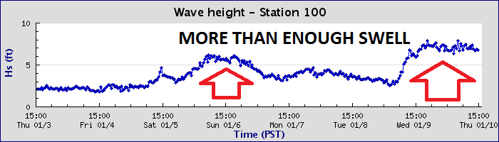
Now that we've all come back down to earth after an epic month of surf, we can finally fix those dings, give our boards a new wax job, patch that fullsuit, and rest our arms. The weather the past few days has been great- but the surf- not so much. 


We did start to see a slow rise in the WNW today and that will peak for chest high waves tomorrow through Saturday. Sunday drops slightly to the waist high+ range. All in all a small clean weekend of surf. 


Water temps are still high 50's and tides this weekend are back to normal too: 1' at dawn, up to 4' mid-afternoon and down slightly to 2' at sunset. 

FORECAST:
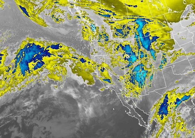
It's funny how the ocean works. You get a couple weeks of rain and big surf and then it takes a breather to rejuvenate itself. That's what we're in the middle of right now. High pressure has set up shop and as it does, it's stunting the growth of storms in the eastern Pacific which leaves us high and dry. 


Models show a small waist high+ WNW towards the 31st and maybe something better around early February but until then- it's slim pickings. Time to put that step up back in the rafters. 


Of note is that the forecast charts show the South Pacific trying to get it's act together- about 4 months early- and we MAY get a small SW swell around the 7th of February. But don't hold your breath. Unless you're duck diving of course. 

WEATHER:


Did I mention high pressure decided to set up shop recently? I did? How about sunny skies are forecasted for the near future with no rain in sight? I did too? Sorry about that- I guess then you've already heard the weather forecast for the next 10 days. Oh- and we may have offshores on Saturday (with temps near 80 at the beaches) and a return of fog in the AM/late nights towards Monday. Other than that- no rain or until at least the end of the month. Pretty nice around here. Make sure to keep track of the waves and weather at Twitter/North County Surf. 

BEST BET:
Tomorrow and Saturday with small but fun WNW swell and nice conditions. 

NEWS OF THE WEEK:


The Pacific Ocean has more good surf than you can shake a stick at. From New Zealand to Peru to Central America to California to Japan and all the islands smack dab in the middle. But there’s more to the Pacific than lines to the horizon. Here’s some facts to amaze your friends with:

Pacific means "peaceful", coming from the Latin "pace" for peace
The Pacific Ocean got its name from the Portuguese explorer Ferdinand Magellan in 1521 who called its waters "mar pacifico" which means peaceful sea.
The Pacific is the biggest ocean on earth and covers more than 30% of the earth’s surface. 
With a surface of 65,436,200 square miles, it provides almost half of the Earth’s water area.
The size of the Pacific Ocean is bigger than the total size of the landmass of all the continents together.
The average depth is about 12,467 ft. 
The Challenger Deep in the Marina Trench (named after the research vessel HMS Challenger in 1875), which is located to the west of the Philippines and north of New Guinea, is the deepest point in the Pacific Ocean at 35,827 feet. It is the lowest part of the earth crust and was formed by the collision of two tectonic plates. 
Most of the volcanoes (actually 75%) on earth are located in the Pacific Ocean basin. The volcanoes form a ring around the basin and therefore is called the ‘Ring of Fire’. Many earthquakes happen in this area due to volcanic activity and then ocean plate moves under the tectonic plates of the continents as well. 
The temperatures of the Pacific Ocean depend on the location. The nearer to the Equator the warmer the water tends to be. So some regions the water is up to 86 degrees (which makes the 80 degree temps off San Diego’s coast this summer even that more remarkable), while closer to the poles the water temperature decreases to the freezing point. The lowest temperature ever measured was 28 degrees. 
Most of the islands in the world are found in the Pacific Ocean. There are actually more than 25,000 islands in the Pacific and most of them are found south of the Equator in the Southern Pacific. Japan alone consists of around 3,000 islands. 

So the next time you’re sitting in the line-up, waiting for that next set, just take a look around and marvel at that big blue ocean you’re floating in. 

PIC OF THE WEEK:


This place has everything to entertain me and my better half: New School ripping for me and Old World charm for her. 

Keep Surfing,

Michael W. Glenn
Birthday Boy
49 Is The New 29
Men's WSL World Masters Quarterfinalist 2015

Thursday, January 17, 2019

THE Surf Report- Early Edition


How good has the last 6 months been?

SURF:


Quite an epic week of surf- if you timed it right. We had solid surf, downpours, clean conditions, windy conditions, small surf, and everything in-between. If you weren't constantly checking it (or had dumb luck), then you missed it. For those of you that did time it right, congrats. Along with the past month or so of good surf, we also had record 80 degree bathtub water temps this past summer; been a good 6 months if I don't mind me saying. 


Tonight a potent storm is barreling through Central California and as it does, surf is marching down the coast. Buoys up north were in the 20-25' range earlier today and we should see 10'+ surf down here early on Friday and 12-15'+ surf in SD. That swell will drop through the day tomorrow. And as the storm moves through tonight, Friday should see sun and scattered clouds but NW winds early. High pressure then sets up behind the storm this weekend and we should have head high sets for Saturday and chest high sets Sunday- with clean conditions. 


Water temps are a chilly 57 degrees and if you dare get in the filthy water, tides this weekend (and early next week) are some of the most extreme of the year. This weekend is around 6.5' at sunrise and down to -1.5' late afternoon (and back to 1' at sunset). On Monday it's almost 7' at sunrise and down to -2' late afternoon. That's an astonishing 9' tide swing! That means the tide will be dropping about 1.5' an hour. 

FORECAST:


After the quick drop in swell over the weekend, we get reversal and a quick rise in the swell on Monday from yet another storm passing by to the N. No rain it looks like for us, but 8' sets instead. That's a fair compromise I think. It may be blustery though from the NW so keep on top of the conditions. After that, high pressure sets up shop and pushes storms to our N so we'll have smaller surf for the foreseeable future. 


Models show a chest high+ NW next Thursday and a slightly better head high+ NW towards the 28th. 


Also, forecast charts show some late (or early) season storm activity off Antarctica this weekend which may give the OC chest high SW swell towards the 28th too. All in all some smaller surf after Monday and cleaner conditions. 

WEATHER:


This past week has been impressive in the way of rainfall (check the details below). We should be done for awhile as high pressure starts to take hold tomorrow and a weak storm moves by to our N on Monday. We'll have sunny skies this weekend, a couple clouds and a breeze on Monday, then a few days of early morning offshores and sun by mid-week. Next weekend looks to be sunny and mild; like a typical Southern California winter. Make sure to keep track of the waves and weather at Twitter/North County Surf. 

BEST BET:
Saturday/Tuesday/Thursday (and maybe the 28th) with manageable swell and winds. 

NEWS OF THE WEEK:


On last week's THE Surf Report, I predicted we'd get 3" of rain at the coast and 12-24" of snow at the So-Cal resorts. How did we end up doing? Pretty spot on:
  • Rain:
    • Ontario 3.66"
    • Newport 2.75"
    • Temecula 2.01"
    • Escondido 1.75"
    • Palm Springs 1.00"
    • Oceanside 1.87"
    • San Diego 0.70"
  • Snow:
    • Big Bear 12.00"
    • Wrightwood 7.00"
    • Mt. Laguna 2.00"

And the extremes were:
  • Mountain High 14.00" of snow
  • Lytle Creek (16 miles NW of San Bernardino, elev. 2790) a whopping 10.30" of rain
  • Glen Helen Regional Park (for all you MX people out there) 9.53" of rain
  • Horsethief Canyon in the Santa Ana Mountains 8.19" of rain
  • Birch Hill in the San Diego County mountains 6.18" of rain
  • Huntington Beach 5.00" of rain
So NOW where do we stand for rain this season? Here goes:
  • Newport Beach 9.86" (163% of normal) and getting close to the seasonal average of 13.30"
  • Oceanside 6.04" (107% of normal) and almost 1/2 way to the seasonal average of 13.66"
  • San Diego 6.43" (152% of normal) and over 1/2 way to the seasonal average of 10.34"
Unless we get hit by an asteroid (that's not funny), I'm thinking we'll make at least our seasonal averages this year with 3 more good months of rain to go...


PIC OF THE WEEK:


Surfing Baja is a lot like surfing California back in the 1800's. This is what Swami's must have looked like when former president John Adams surfed (a little known historical fact). 

Keep Surfing,

Michael W. Glenn
Mover & Shaker
Having a Hard Time Finding a Mega Yacht Within My Budget
Wore an Astronaut Suit in the Dirty Surf This Week So I Wouldn't Get Sick 

Thursday, January 10, 2019

THE Surf Report- Early Edition


Anyone besides myself seen this El Nino guy lately?

SURF:
I've been talking for a few months that models last summer showed our water temps rising above average again and we may be headed to an El Nino this winter. Well, I'm just taking a wild guess and saying that he's back. Can't confirm since most of NOAA is shutdown due to some government issues I won't get into, but by the looks of our rainfall totals and 12' surf recently, that's all the confirmation I need. 


This past week had a quick rise in the surf on Wednesday and today was still firing. We've got a smaller more manageable day tomorrow then the waves & weather kick into high gear again for at least the next 10 days. 


First up is a storm taking shape today that will barrel down the coast on Saturday and give us overhead NW again late Saturday into Sunday morning. The storm that generated it though will be arriving at the same time too so look for lots of rain and windy conditions. Best bet is to get it Saturday afternoon before the rain/wind gets too heavy and the new swell starts to show. Sunday will be a windy mess from the NW as the storm exits the region. Water temps have dropped to the high 50's thanks to all those swells recently. 


And tides are non-existent this weekend- about 2' at sunrise, up to 3' at lunch, and back down to 2' at sunset. 

FORECAST:
After this weekend's wave appetizer, we get a salad on Monday, a side dish on Wednesday, an entree next Friday, and a dessert on Sunday the 20th. Basically we have swells and stormy conditions lined up with varying degrees of 6-8'+ surf lined up on...

Monday the 14th...


Wednesday the 16th...


Friday the 18th and Sunday the 20th. Now I'll be the first to admit- I have no idea on when you should surf. With all these storms lined up, it will be impossible to forecast if the wind will be calm, breezy, or downright blustery. And that's just in a 12 hour period. Basically keep your board and wetsuit in your car and jump on it at the first sign of clean conditions!

WEATHER:


Where do I start? Nice to have some weather to talk about finally! After saying for months 'night/morning low clouds/fog and afternoon sun’ I can actually say we're going to get dumped on- here and in the mountains (for all my Snow-Bros out there). First storm will arrive Friday night and last around mid-day on Saturday. We should get 1/2" to 1" and 20 mph+ winds at the coast. On it's heels are a couple weaker cold fronts Sunday through Tuesday that may give us 0.5" of rain and weaker winds. And if the models are correct, looks like a solid storm on Wednesday the 16th with 2" of rain at the coast and 30 mph winds. In total for the week we could see 3" of rain and 1-2' feet of snow in the local mountains. And models show maybe another storm next weekend. Winter is officially here. Make sure to keep track of the waves and weather at Twitter/North County Surf. 

BEST BET:
This one's on you. Lots of surf and storms lined up from late Friday night to next Sunday the 20th. Could be a little window of clean/manageable surf in-between those days but we won't know until it happens!

NEWS OF THE WEEK:


Doing great so far with our rain this year. As predicted a few months ago- this was going to be mild El Nino and the rainfall totals (and surf heights) and have reflected that. We're slightly above average for rainfall this year and the surf really hasn't gotten over 12' here in north county or triple overhead in San Diego. If it was a full blown El Nino, I would have expected 25'+ surf already at La Jolla Cove and 10” of rain. But there's still time! What were we talking about again? Oh- rainfall this season. Here's where we stand:
  •          Newport Beach: 6.08" so far. Normal this time of year is 5.17". 118% of normal.
  •         Oceanside: 4.26" so far. Normal this time of year is 4.89". 85% of normal.
  •          San Diego: 5.30" so far. Normal this time of year is 3.70". 143% of normal.

For our total rainfall in a season, we should see around 10-13" of rain, so we're about 45% of the way there. Along with the expected 2-3" next week, we should be well above average and getting close to that 10-13”. With about 4 more good months of rain on the horizon, I wouldn’t be surprised to see 12-15” of rain this year. Fill up those reservoirs!

PIC OF THE WEEK:


I have a love/hate relationship with Ocean Beach, San Francisco. Love that there's waves all the time. Hate that it's 40' beach break. Case in point with today's Pic of the Week: Just think if you were surfing the 'inside' 12-15' bombs and already paddling for dear life THEN scratch over a set and see those things feathering a mile out to sea. So awesome.

Keep Surfing,

Michael W. Glenn
Avant-Garde
Play In A Twisted Sister Tribute Band Called 'Gnarly Bro'
Won't Surf My Lazor Zap For Fear Of Electrocution

Thursday, January 3, 2019

THE Surf Report- Early Edition


Like clockwork. 

SURF:
Winter has been pretty much on track the past few months. Firing surf, some rain, then smaller sunny offshore days, and repeat. 


The past week was no exception as the swell slowly subsided and was replaced by clean conditions and sunshine. That means we're due for bigger surf and wetter conditions- and wouldn't you know it- that's what we have on tap this weekend. Friday starts off small and clean then we have increasing S winds in the afternoon on Saturday as a new cold front approaches. We might see a small increase in NW swell late on Saturday but the S winds from the approaching storm will blow it to bits. 


Sunday looks to be windy from the WNW with overhead storm surf and showers in the AM. Basically it's small Friday/Saturday and big/stormy Sunday. Water temps are holding at 60 degrees and tides this weekend are simple yet extreme. We basically have 2 tides at the opposite ends of the spectrum; 6' at breakfast and -1' late afternoon. 

FORECAST:
Monday cleans up as the cold front exits the region and we have a shoulder high sets. 


Tuesday backs off slightly to the chest high range then we get a building NW again on Wednesday- along with a stronger storm late in the day (it's winter- what did you expect?)- for overhead bumpy surf by Thursday. 


Surf cleans up/drops next Friday/Saturday then models show a small chest high bump next Sunday the 13th. On it's heels, the same models are showing a bomb of a storm between Japan and Hawaii which may give us double overhead surf again mid-January. We're still 2 weeks out so take it with a grain of salt. But it looks like we're at least in an active pattern in the near term. 

WEATHER:


Get that yard work done on Saturday because Sunday will be messy. Not a big storm- a lot like the Xmas rains- but enough wind and rain to keep you in doors. Monday and Tuesday is clean and sunny but then a slightly larger storm is poised to arrive by late Wednesday into Thursday. Models can't make up their minds with this one but we may get close to an inch of rain. Once that moves through, we should have good weather next weekend. Make sure to keep track of the waves and weather at Twitter/North County Surf. 

BEST BET:
Most likely Monday with small clean surf as the bigger days on Sunday/Thursday will be met with rain. Or hold out until mid-month when the forecast charts show a doozy of swell arriving again. 

NEWS OF THE WEEK:


Big fan of Hawaii? I am. Warm water. The 7 Mile Miracle. Don/Mason/Coco/Michael/Derek Ho. Shave ice. Ted’s Bakery. More fun than you can shaka stick at. Never been? Better hurry - a team of researchers from the University of Hawai'i at Mānoa (UH Mānoa) and the Hawai'i Department of Land and Natural Resources (DLNR) determined that land area in Hawai'i vulnerable to future sea level rise may be double previous estimates. Woops. Here’s what their findings in the Nature journal, Scientific Reports recently published:
"The bathtub method (a widely-used approach for assessing impacts of sea level rise where the ocean surface is projected onto a terrain model) provides a good first look at low-lying flood-prone areas but underestimates the full extent of potential damage due to sea level rise, particularly on Hawaii's high-energy coasts," said lead researcher Tiffany Anderson, a faculty member in the Department of Earth Sciences at the UH Mānoa School of Ocean and Earth Science and Technology (SOEST).
As sea level rises, several processes are at work- coastal erosion results in permanent land loss but is also essential for preserving beaches; annual wave flooding rapidly escalates past a critical point; groundwater inundation and storm-drain back flow create new wetlands and cause urban flooding. These render coastal armoring insufficient as an adaptation strategy.
"Our more comprehensive assessment reveals important realities that can be overlooked with other methods. Critically, the "bathtub" approach, alone, ignores 35-54 percent of the total land area exposed to one or more of these hazards, depending on location and SLR scenario," said Chip Fletcher, co-author of the study and associate dean and earth sciences professor at SOEST.
The team also found that typical elevations of Hawaii's low-lying coastal plains create thresholds of flood levels, above which rapid increases in flooding occur. As sea level rises, coastal lands are exposed to higher flood depths and water velocities. The prevalence of low-lying coastal plains leads to a rapid increase in land exposure to hazards when sea level exceeds a critical elevation of about 1 to 2 feet, depending on location. The team had identified this phenomenon in previous research and named it a "critical point."

"Additionally, a large portion of lands at risk of flooding are not in direct proximity to the shoreline," said Anderson. "Instead, they are low-lying areas where sea level rise causes the groundwater table to rise up to the surface. These areas can be located one to two miles inland from the coastline."
"It's important that we identify land areas vulnerable to sea level-related hazards because, if left unmanaged, flooding, wave inundation, and erosion will continue to encroach upon coastal lands that are typically heavily developed," said Fletcher. "Preparing for these effects will be very costly and take a long time to implement. With these results, stakeholders of all types are now able to establish empirically-based adaptation policies."
The modeling presented in this study was conducted to support the creation of the Hawai'i Sea Level Rise Vulnerability and Adaptation Report, which is the basis for further government planning initiatives.
"We can always count on these researchers at SOEST to provide the State with cutting edge research and modeling to improve our understanding of coastal hazards," said Sam Lemmo, study co-author and DLNR administrator. "Their work is immediately translatable to policy and regulatory guidance at the local level. Our goal was to create a scientifically rigorous visual tool to highlight the gravity of sea level rise in our islands to prepare our communities and government bodies for its impact, as well as to provide tools necessary to reduce the shock to our socio-economic system."
Anderson and team are currently incorporating rainfall into the computer model to determine how sea level-related flooding might be exacerbated during rainfall events that occur during high tides. Hawai'i Sea Grant, also located at UH SOEST, and Tetra Tech, Inc. are helping guide State and county agencies in considering this new data in future planning.
So if you haven't booked your ticket yet to Hawaii for the summer- do it now. 
PIC OF THE WEEK:


I'd tell you where this is but I don't to expose this secret spot in R#0d3 15!@nd. 
Keep Surfing,

Michael W. Glenn
Plays Well With Others
Maxed Out My Black Card
Completed My A to Z Bucket List And Surfed Every Spot From Anglet to Zippers