Thursday, September 24, 2020

THE Surf Report- Early Edition


How do you turn this thing on?


SURF:


Been so long since I turned on the Emergency Boardriding System that I forgot how it works. Plus it's dusty, full of cobwebs, and I'm hoping rats didn't gnaw the wires. 


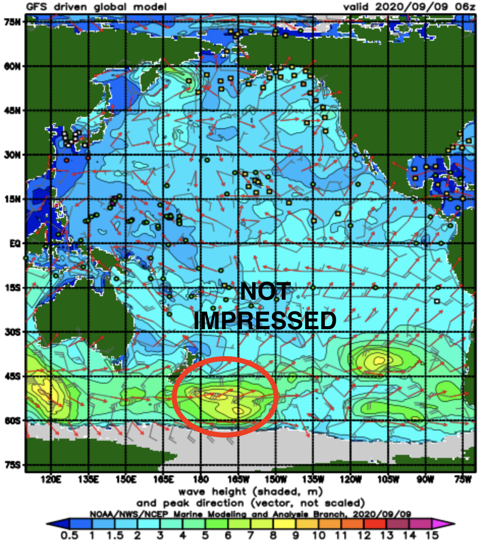
Lucky for us, there's already good WNW filling in on the Central Cal buoys tonight so we should see some sets in the AM with more consistent surf by Saturday morning. Fire up the hype machine! But first things first: Our first real storm of the season from the Aleutians is sending good WNW swell our way for Friday afternoon into Saturday morning. Look for chest high sets in the AM and head high surf by Saturday morning with overhead waves in SD. By Sunday the swell is on its way down but we'll still have waist to chest high surf. We also have some waist high S swell in the water from Tropical Storm Lowell but it will be overrun by the new WNW. And here's the tides, sun, and water info:

  • Sunrise and sunset:
    • 6:40 AM sunrise   
    • 6:39 PM sunset  

  • And our water temps are in the high 60's. Supposedly... there's a heat wave coming next week- maybe we'll be back to the low 70's by next weekend?
  • And the tides this weekend are simple:
    • 4.5' at breakfast
    • 2' after lunch
    • 5' at sunset

FORECAST:

I sure hope I put batteries in the Emergency Boardriding System 'cause we're going to need it for next week too. 


After the WNW runs it course this weekend, new late season SW starts to fill in Monday afternoon for chest high surf and back to head high sets by Tuesday morning. That starts to fizzle by Wednesday afternoon. The storm that generated this new swell would have given us bigger surf but it was aimed towards South America so we'll just get a glancing blow. But back to back head high swells the next 7 days is nothing to sneeze at. 


After that, the Pacific takes a little breather the 2nd half of next week but maybe by late next weekend we'll see more fun sized chest high sets from the WNW and after that- more chest high surf from the southern hemisphere around the 5th. Make sure to check out Twitter/North County Surf if anything changes between now and then.


BEST BET: 

Late Friday/early Saturday with good WNW. Or late Monday/early Tuesday with good SW. So many waves and so little time. 


WEATHER:


The Aleutian storm mentioned above will pass by to our N and we'll have pleasant fall weather down here Friday and Saturday. Look for typical low clouds/fog in the nights/mornings and temps in the low 70's at the beaches. As that storm exits the western US, high pressure starts to build behind it and unfortunately a Santa Ana condition sets up for the majority of next week. Look for offshore winds for most of the deserts, mountains, and inland valleys and most likely calm winds at the beaches. Don't get me wrong, I like the nice weather, but the offshore winds and low humidities lead to critical fire weather of course. Temps at the beaches should peak in the mid-80's late next week. 


NEWS OF THE WEEK: 


This day in weather history! (Try to contain your excitement):

1997: Heavy rain and thunderstorms developed on this day and ended on 9/26. Moisture came from the remnants of Hurricane Nora, which had moved up the Gulf of California and weakened over Yuma, AZ, giving that city more rainfall in three hours than for a normal entire season. Rainfall totals were 5.50 inches at Mt. San Jacinto, 4.70 inches Mt. Laguna, 4.41 inches Mt. San Gorgonio, three to four inches at several other locations in mountains, 3.07 inches in Twentynine Palms, 1.5 to two inches at Coachella and Borrego Valleys, 2.88 inches in Hemet, and one to two inches in many inland areas. Flooding occurred in Palm Springs, Borrego Springs, and Spring Valley. Traffic deaths also resulted.

1986: Unseasonable rainfall hit San Diego County on this day and on 9/25: 1.04 inches fell in San Diego, 5.14 inches in Palomar Mountain, 2.07 inches in Julian, 1.95 inches in Los Angeles, 1.88 inches in Mt. Laguna, 1.61 inches in Lemon Grove, 1.58 inches in Pt. Loma, 1.57 inches in Vista, and 1.47 inches at SDSU. Flooding occurred in low roadways in Mission Valley. Power was knocked out over a wide area. Home games for the Angels and Dodgers were rained out.

1982: The remnants of Hurricane Olivia recurved northeastward across Southern California with rainfall up to four inches in the mountains starting on this day and ending on 9/26. This occurred during the strong El Niño of 1982-83. 

1976: A thunderstorm dropped four inches of rain in three hours in Borrego Valley. Only 1.2 inches fell at the Anza Borrego Desert State Park headquarters. Damage and erosion to fields, property, and the airport resulted. 

1963: Thunderstorms hit the San Bernardino Mountains and high desert around Barstow, producing flash flooding east of Barstow. 

1945: It was 26° in Idyllwild, the lowest temperature on record for September. This also occurred the previous day on 9/23/1945, on 9/20/1965, and on 9/21/1968.

1939: A thunderstorm on this day dropped 6.45 inches in six hours at Indio. This preceded “El Cordonazo” or “The Lash of St. Francis”, an actual tropical storm. For the entire storm, which started on this day and ended on 9/26, four inches of rain fell across the deserts and mountains as a dying tropical cyclone moved across Baja California into southwestern Arizona. This was the second tropical cyclone to impact California during the busy month of September 1939. A strong El Niño may have contributed to the activity. The tropical storm produced 50 mph winds over the ocean and estimated seas of 40 feet. 48 died from sinking boats and harbors were damaged. Californians were generally unprepared and were alerted to their vulnerability to tropical storms. In response, the weather bureau established a forecast office for Southern California, which began operations in February of 1940.

PIC OF THE WEEK:


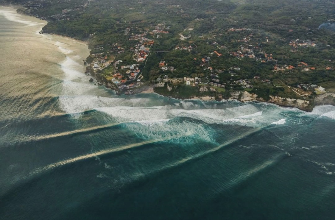
Indo, Australia, Japan, the East Coast, and Europe have ben really good lately. Is it our time finally?


Keep Surfing,


Michael W. Glenn

El Guapo

Gravity Defying

My Wife Is Throwing Me A Party Wave For My Next Birthday

Thursday, September 17, 2020

THE Surf Report- Early Edition


Karina: \ ˈkuh-rē-nuh \ adjective. Definition: More impressive than it looked.


SURF:

Didn't see that coming. Tropical Storm Karina (noticed I said, Tropical Storm, not Hurricane), sent fun waves our way the past couple days and I didn't think much of her earlier in the week. Charts showed her with peak winds of 50 mph (Note- a real hurricane like Maria had 160 mph winds) and Karina was moving away from us. The secret ingredient though? Karina was larger in size than most tropical storms and lasted a couple days in our swell window. The result? Shoulder high sets (and bigger in the OC) and plenty of waves to go around. Karina unfortunately has faded but we still have fun waves on tap this weekend. 


First up is a small SW filling in tonight to keep us in waist high+ waves tomorrow with chest high sets towards the OC. We then get a small early season NW on Saturday for more waist high surf with chest high sets towards SD. And then... we start to see a new SW on Sunday for chest high sets. Still no big surf but fun this weekend. And check this out:

  • Sunrise and sunset:
    • 6:37 AM sunrise   
    • 6:46 PM sunset  
    • For those of you keeping score, that's 12 hours and 9 minutes of sun and 11 hours and 51 minutes of night. Which means...The first day of fall is Sunday! So next week we'll have more daylight than night: 11 hours and 59 minutes of light and 12 hours and 1 minute of dark skies. When do we start gaining more sun and less night? December 20th. 

  • And our water temps are holding at 70. Going to make those cool fall morning dawn patrols more tolerable.
  • And the tides this weekend are easy to remember:
    • 1' at breakfast
    • 6' at lunch
    • 1' at dinner

FORECAST:

Summer couldn't end quick enough. From red tide, beach closures, flat surf, freezing water, smokey skies, crazy crowds- fall is a welcome change of pace. Karma must be on our side finally because we have good swells lined up in the near future. (If everything comes together, I'll turn on the Emergency Boardriding System at next week's THE Surf Report). The SW from late Sunday rolls into Monday with more waist to chest high surf. One fly in the ointment is that a cold front to the N of us early next week may increase our SW winds down here. Nothing major but just enough to blow out the surf mid-day. 


Then next Friday, we should see our first real NW of the season for shoulder high surf in North County SD and head high surf in SD. 


And then it looks like summer doesn't want to quit in the southern hemisphere as there's a solid storm forecasted to form in a couple days which would give us head high+ SW around the end of the month. Make sure to check out Twitter/North County Surf if anything changes between now and then.


BEST BET: 

This weekend with small but fun SW/NW or next Friday with good NW or... the end of the month with good SW!


WEATHER:


Great weather today as the smoke finally thinned out and air temps hit 80 at the beach. Throw in some surf today and warm water and it seems like all the problems this summer were washed away. Look for another nice day tomorrow before the low clouds/fog return in the nights/mornings this weekend from a cold front passing by to the N. Temps will also drop slightly to the low to mid-70's. High pressure should build slightly the 2nd half of next week for warmer weather and less clouds. 


NEWS OF THE WEEK: 


As you've probably heard by now, we are in a slight La Nina pattern for the upcoming fall/winter. The Cliffs Notes version is a potentially warmer than normal atmosphere winter and less rainfall than normal. Less rainfall is not good for our wildfire situation down here in Southern California of course. Here's the LA Times to shed light on the situation:


A La Niña climate pattern — which often means a busier Atlantic hurricane season, a drier Southwest and perhaps a more fire-prone California — has appeared in the Pacific Ocean. The National Oceanic and Atmospheric Administration announced the La Niña’s formation on Thursday after meteorologists had watched it brew for months. It’s the cooler flip side of the better known El Niño, which tends to bring increased rainfall to the Golden State.


A natural cooling of certain parts of the equatorial Pacific, La Niña sets in motion a series of changes to the world’s weather that can last months, even years. So far, this one is fairly weak. It’s projected to last through at least February but may not hang around for two or three years, as others have done in the past, said Mike Halpert, deputy director of the NOAA Climate Prediction Center. 


The changes that happen during La Niñas and El Niños — which along with neutral conditions are called the El Niño Southern Oscillation, or ENSO — aren’t sure things, meteorologists say. Different sizes and types trigger varying effects, and some years the usual impacts just don’t show up. It’s more an increased tendency than an environmental edict. Still, when it comes to seasonal forecasts in places such as California, if meteorologists can get only one piece of information, they’d want it to be the ENSO status, said Stanford University climate scientist Noah Diffenbaugh.


Here’s a closer look at what this La Niña may have in store.


How does La Niña affect U.S. weather in general?

The jet stream that steers our daily weather shifts a bit in the winter. That generally means a drier winter in the South and Southwest from coast to coast. It usually means things are a bit warmer in the South, too. However, in the Pacific Northwest and the Ohio Valley things get wetter in the winter, and the Northern tier becomes colder.


What about the drought in the West?

Drought conditions are already pretty bad in west Texas, Arizona, Utah and Colorado, Halpert said. This could make things worse. And California has “a tendency to have dry conditions in La Niña years,” Diffenbaugh said.


What does this mean for wildfires?

“La Niña is not a good sign for the wildfire outlook,” Diffenbaugh said. But he added that it’s mostly a potential bad sign for next year’s wildfire season because it makes California’s winter season drier, setting the stage for dry conditions when fires start in 2021.


What about winter snow possibilities?

La Niña has a tendency to shift snowstorms more northerly in winter, Halpert said. Places such as the mid-Atlantic often do not get blockbuster snowstorms in La Niña winters. Overall, winter should be cooler than last year, but “last winter was so warm it would be hard not to be cooler,” Halpert said.


Which is worse, La Niña or El Niño?

That really depends on where you are. Some areas do better in La Niña conditions, some are better with an El Niño, and others do best in a neutral ENSO, said Bruce McCarl, an agricultural economist at Texas A&M University who studies ENSO effects. Places such as Texas and the Southwest do much worse in La Niñas, McCarl said, pointing to a 2011 La Niña when 40% of the cotton crop in the high plains was too small to be harvested. A 1999 study by McCarl found that, in general, La Niñas cause $2.2 billion to $6.5 billion in agricultural damage — far more than El Niños. A neutral ENSO is best for agriculture, the study found.

When were the last La Niña and El Niño?


The last La Niña went from the fall of 2017 to early spring in 2018. Before that, there was a brief La Niña at the end of 2016, coming on the heels of a super-sized El Niño. This year started with a brief, weak El Niño.


Why is it called a La Niña anyway?

La Niña is Spanish for “little girl,” and El Niño means “little boy,” a reference to the Christ child. That’s because the first El Niño was characterized and identified around Christmas by fishermen in South America.


PIC OF THE WEEK:


Why is this placed called Skeleton Bay? Thanks for asking. The area's name derives from the whale and seal bones that once littered the shore from the whaling industry, although in modern times the coast harbors the skeletal remains of the shipwrecks caught by offshore rocks and fog. Or- you're a deadman trying to paddle back out against the current at this spot. 


Keep Surfing,


Michael W. Glenn

Husky (As In Burly, Not The Dog)

Lakers. Take That To Laughlin

Starring In A Reality TV Show Called 'Surfivor'

Thursday, September 10, 2020

THE Surf Report- Early Edition


How you holding up?

SURF:


That was one wild week. We had SW swell, NW swell, cold water, warm water, crowds, smoky skies, S winds, N winds, and the kitchen sink thrown in for good measure. Things have quieted down a bit today but we still have a touch of SW in the water. 


We have a new small SW filling in tomorrow (the 3rd in a row that started last week) for waist high+ surf with chest high waves towards the OC. This weekend is more of the same- just waist high+ SW/NW and semi clean conditions. And here's some numbers for you to digest:
  • Sunrise and sunset:
    • 6:31 AM sunrise   
    • 6:57 PM sunset  
  • And our water temps have rebounded to the low 70's again! Hallelujah. No major NW winds are forecasted in the near future so those temps should hold at least from the high 60's to the low 70's through the weekend. 
  • And the tides this weekend are mostly medium to high:
    • 4' at breakfast
    • 3' at lunch
    • 5' at dinner
FORECAST:
After a slow weekend, the surf starts to pick up slightly next week. Monday/Tuesday look small then we get building NW windswell late in the day on Wednesday for chest high sets. 


That's met by a small SW on Thursday for more consistent chest high combo swell. 


On its heels is a long period early season NW swell for chest high sets towards SD around next Friday.


And after THAT... models show a good storm forming off New Zealand this weekend which may give us head high SW the around the 21st. Make sure to check out Twitter/North County Surf if anything changes between now and then.

BEST BET: 
Might as well wait until the 2nd half of next week when more NW windswell, NW groundswell, and SW groundswell should arrive. SHOULD being the key word here- because anything goes with our climate nowadays. 

WEATHER:


You like tropical clouds? Check. Smoky skies? Check. Desert-like heat? Check. Low clouds and cool temps? Check. Strong S winds or N winds? Check. Check. Check. Check. Check! We had a little bit of everything last week. In fact, Southern California has recorded 3 unfortunate records in regards to temperatures in the past month (more on that below in the News of the Week). Whether you believe in Global Warming or not, there's no doubt something is causing us to warm up and it's not looking good. Another oddity is the wildfires raging out of control in the West have given us additional cloud cover- which has dropped our temperatures by a few degrees. This weekend, high pressure will still be in control and we'll just have the usual low clouds/fog in the nights/mornings (as well as hazy skies from the smoke) and temps in the mid-70's again at the beaches. Models show a low pressure system moving by to the N the 2nd half of next week and we'll have slightly cooler temps and more low clouds/fog. Hopefully the low pressure will clear the air of our smoke. And no big heat wave in the near future fortunately.

NEWS OF THE WEEK: 

As mentioned above, we've hit some milestones recently here in California (and the Earth for that matter)- that we should not be proud of. As you're well aware, we're warming up. So much so that August 2020 will be remembered for its extreme heat and violent weather: The U.S. endured heat waves, hurricanes, a devastating derecho and raging wildfires out West. Meteorological summer — June through August’s end — was a standout: It ranked 4th hottest and in the driest one-third of all summers in the historical record. Here are more highlights (or lowlights I guess) from NOAA’s latest monthly U.S. climate report: 

The average temperature for August across the contiguous U.S. was 74.7 degrees F (2.6 degrees above the 20th-century average) and ranked third-hottest August on record. Arizona, California, Colorado, Nevada, New Mexico and Utah each had their warmest August on record. In particular, Phoenix, Arizona, had its hottest month ever recorded, with an average temperature of 99.1 degrees F. For meteorological summer (June through August), the average temperature for the contiguous U.S. was 73.6 degrees F — 2.2 degrees above the average. Summer 2020 ended with the ranking of 4th-hottest summer on record. 


If that's not bad enough, we have 3 weather records that were broken the past few weeks that happened here in California. First record as you know, Death Valley reported a high temperature of 130 degrees F. If that reading is verified by climate scientists, a process that could take months, it would be the highest temperature ever reliably recorded on earth. In the popular imagination, Death Valley is the hottest place on earth and is no stranger to heat. Sitting 282 feet below sea level in the Mojave Desert in southeastern California near the Nevada border, it is the lowest, driest and hottest location in the United States. It is sparsely populated, with just 576 residents, according to the most recent census. Brandi Stewart, the spokeswoman for Death Valley National Park, said that the valley is so hot because of the configuration of its lower-than-sea-level basin and surrounding mountains. The superheated air gets trapped in a pocket and just circulates. “It’s like stepping into a convection oven every day in July and August,” she said.

So to recap, August across the US was the 3rd hottest on record and earth may have seen it's hottest temperature ever, in our own backyard. But what about west of the mountains here in Southern California? Well, that's record #2. CNN reported this week that Los Angeles County recorded its highest-ever temperature last Sunday as the weekend heat fanned wildfires across California and put additional strain on the state's power network. The record temperature was at Woodland Hills, according to Dave Bruno, senior meteorologist for the National Weather Service. "We reached 121 degrees Fahrenheit; that is the highest-ever temperature at a station, beating 119 degrees on July 22, 2006," The temperature is also the highest recorded in the Los Angeles County warning area, which includes Ventura, Santa Barbara and San Luis Obispo Counties, a tweet from the National Weather Service Los Angeles said Sunday. Basically, anything W of the mountains here in Southern California (including Orange and San Diego Counties). "Woodland Hills is the last place to get the effects of sea breeze. It's tucked in the west corner of the San Fernando Valley," Bruno explained. "This record heat was in a perfect or imperfect situation. High temperatures from surface to atmosphere, weak offshore flow and just enough to keep away the sea breeze." 


And if that's not unsettling enough, the high temperatures come as firefighters battle wildfires around the state- record #3 unfortunately- the worst year on record in terms of the amount of land scorched. CBS News reports that California has yet to reach the peak of this year's fire season — but deadly wildfires across the state have already burned more acres than any year on record. According to Cal Fire, 2.2 million acres have burned so far, and the season is far from over. Two of the three largest fires in California's history are currently burning in the San Francisco Bay Area. The SCU Lightning Complex has burned more than 396,000 acres and is 95% contained as of Tuesday, and the LNU Lightning Complex has burned more than 375,000 acres and is 91% contained as of Tuesday. The Creek Fire, which erupted Friday, has already become the third-largest that is currently active, burning more than 152,000 acres. It is 0% contained as of Wednesday morning. The fires have killed at least eight people and destroyed upwards of 3,300 structures, Cal Fire said. Most of the state remains under Red Flag Warning as strong winds and low humidity continue, exacerbating ongoing flames. The previous record for acres burned was set just two years ago. It included the deadliest wildfire in the state's history- the Camp Fire, which swept through the community of Paradise and killed 85 people. Cal Fire said that the Golden State has seen over 2,650 more fires and a nearly 2,000% increase in the acres burned year-to-date compared with 2019. By this time last year, 4,927 fires burned through 117,586 acres. Lynne Tolmachoff, a spokeswoman for Cal Fire, said it's "unnerving" to have reached a record for acreage burned when September and October usually are the worst months for fires because vegetation has dried out and high winds are more common. Due to the drought across the West Coast, "peak" fire season is predicted to last through the middle of September, according to the National Interagency Fire Center. The end of the month will see a break in activity thanks to cooler temperatures, but winds could stir up more problems again in October.


So to recap:
  • The US had its 3rd hottest August on record
  • The US had its 4th hottest summer on record
  • Planet Earth unofficially had its hottest temperature ever in Death Valley at 130 degrees Fahrenheit
  • Southern California had its hottest temperatures ever west of the deserts at 121 degrees Fahrenheit
  • And California has seen the 2 of its top 3 biggest fires on record and already hit a record for most scorched acres
I tell you, between the high cost of living, the heat, the fires, and dealing with the Kardashians, California is not an easy place to live. 
 
PIC OF THE WEEK:


My great great great grandpa took this picture of Seaside Reef when he discovered it back in 1878. He was the first person to surf it and even has video to prove it. As soon as I find my Betamax, I'll show it to you. 

Keep Surfing,

Michael W. Glenn
Public Figure
Here I Go, Again On My Own, Goin' Down The Only Road I've Ever Known
Developing A Top Secret New Wetsuit With A Certain 2 X World Champ Called The 'Short John John John'

Thursday, September 3, 2020

THE Surf Report- Labor Day Weekend Edition!


This is a test of the Emergency Boardriding System. This is only a test...

SURF:


The end of August is supposed to be the hottest time of the year, right? But instead we get below average air temperatures, below average sea surface temperatures, clouds sticking along the coast, no surf, and WNW wind everyday. Pretty sure we're being filmed for Punk'd, Impractical Jokers, Candid Camera, Jackass, Fear Factor, AND Crank Yankers, all at once. But fear not- I'm going to test out the Emergency Boardriding System this weekend to see if it still works. Remember, this is only a test. So what do we have on tap for the long holiday weekend? First up is waist high+ NW windswell and background SW swell for Friday- and much better weather. 


We did though have a good storm off New Zealand a few days ago and it looks like we'll have building chest high+ SW swell arriving late Saturday and lasting through Monday. As you head towards the OC, it should be a foot bigger. But what's the wind and weather doing? Will it finally coincide with the surf? Yes, finally the weather and water temps will feel like summer. Looks like we've got a heat wave building and temps along the beaches will hit the high 80's by Sunday. This may also help boost our water temps back to 70 degrees. Wonder if it will be crowded? (You already know the answer to that). So why just a test of the EBS this weekend and not just turn the darn thing on?! Well, the Waves & Weather will coincide this weekend but it won't be big. Think fun instead of firing. Regardless, enjoy the surf and take heed of the following info:
  • Sunrise and sunset:
    • 6:26 AM sunrise  (6:15 if you push it)
    • 7:07 PM sunset (7:15 if you push it)
  • Due to the WNW wind the past 2 weeks, water temps dropped to the low 60's as you know and are hovering around 68 today. Hopefully with the heat wave this weekend though, water temps will hit the low 70's by Monday. 
  • And the tides this weekend are easy to remember:
    • 1' at breakfast
    • 4.5' at lunch
    • 1' at dinner
FORECAST:


After the 1st SW swell this weekend, we get a smaller reinforcement from a 2nd storm that arrives on Tuesday as well as more NW windswell.That will keep us in chest high+ surf. 


On it's heels is yet another small but fun SW swell for chest high sets the 2nd half of next week. Finally some rideable surf around here! Nothing big again but at least chest high sets later next week. Get on it because after that, the models show it going flat again. Make sure to check out Twitter/North County Surf if anything changes though!

BEST BET: 
This weekend with great Waves & Weather or next Tuesday with a slightly smaller SW but better NW. Or the 2nd half of next week with small but fun SW. 

WEATHER:


Unless you've been living under a rock, then you know about the heat wave starting tomorrow. High pressure will be large and in charge, squashing the low clouds/fog and raising our air temps to the mid-80's by Saturday and maybe 90 by Sunday. Let's hope that helps raise the cool water temps. By Monday, the low clouds may return briefly as a weak cold front moves through the Pacific NW, but we'll still have temps near 80 at the beaches for the holiday. Models hint at light offshore flow on Tuesday due to the cold front mentioned above, but that seems REALLY early for that to happen. BUT... there was a dusting of snow earlier in the week in the Rockies, so maybe we're starting winter early this year? Our water temps sure feel like it. For the latter part of next week, we should be back to milder weather with temps in the mid-70's at the beaches. 

NEWS OF THE WEEK: 


Over the years I've done various stories about our tides- how they work, difference between spring and neap tides, the Bay of Fundy (i.e. a 43' tidal swing; in comparison, the most we have here is 9'), and what causes them. The biggest influence? The moon. Did you know though, the moon is slowly moving away from earth? What's going to happen when it's too far away to make a difference (that's a long way away- so don't worry). Here's a recent report from the Business Insider to shed light on the subject:

Our moon is on the move. Each year, it drifts an estimated 1.5 inches further away from Earth. And in the process, Earth's rotation is actually slowing down. What if one night, the moon simply disappeared? Would we miss it? (The answer is 'yes' of course).


A full moon is on average 14,000 times brighter than the next brightest night-sky object, Venus. So without it, every night would be as dark as a new moon. And star gazing would be spectacular. But by the next morning, you'd begin to realize just how important the moon is for life on Earth. To start, between the sun, Earth's rotation, and the moon, the moon has the largest influence on Earth's tides. Without it, high and low tides would shrink by an estimated 75%. This would jeopardize the lives of many types of crabs, mussels, and sea snails that live in tidal zones and disrupt the diets of larger animals who rely on them for food, threatening entire coastal ecosystems in the process. Within a few decades, we would start to see mass population declines in the sea and on land. One of the largest spawning events in the world occurs in the Great Barrier Reef. Each November in the days following the light of a full moon, coral colonies across the reef - spanning an area larger than the state of New Mexico - release millions of egg and sperm sacs within nearly minutes of one another. Scientists are certain that the full moon plays a role in the timing, but exactly how remains a mystery. On land, animals like these Red Crabs also use lunar cues to reproduce. After living most of their lives in the mountains, millions of adult crabs migrate down to shore. And then, only during the last quarter of the moon, females release their eggs into the sea.

Now, the moon may not hold as much sway over human reproduction. But without it, something else we care equally about would change - the weather. Tides and tidal currents help mix cold arctic waters with warmer waters in the tropics. This balances temperatures and stabilizes the climate worldwide. Without the moon, weather forecasts would be practically impossible. The average difference between the hottest and coldest places on Earth could grow to life-threatening extremes.


But none of this compares to the biggest change that we would have coming over the next millennia. Right now, Earth tilts on its axis at 23.5º mostly due to the moon's gravity. If the moon disappeared, Earth's axis would wobble between anywhere from 10 to 45º. Some experts estimate that Jupiter could help keep Earth's tilt from reeling completely out of control. But even just an extra 10º tilt could wreak havoc on the climate and seasons. In the past, Earth's tilt has changed by about 1-2º, which scientists think could have caused Ice Ages in the past. It's hard to know what a 10º or 45º tilt would do but probably nothing good for most life on Earth.

The moon isn't just imperative for life on Earth today. Experts believe that it may also have played a key role in the formation of life more than 3.5 billion years ago. Turns out, the moon isn't just a beacon of light in the night sky. Its existence is crucial to the delicate balancing act that makes life here possible.

PIC OF THE WEEK:


You take this one, I'll get the 12th one. 

Keep Surfing,

Michael W. Glenn
Savvy
Only Conspiracy Theories I Believe In Are Bigfoot & The Loch Ness Monster
1st Surfer To Ever Do A Cutback, Air, Floater, Off The Lip, Carve, Rock & Roll, Tailslide, Barrel, Layback, Snap, Roundhouse, Tail Whip, & Reverse On 1 Wave