Thursday, May 25, 2023

THE Surf Report


Palm Springs Wave Pool Where Art Thou?

SURF:


Quite the week around here. Clouds. Drizzle. Constant W wind. Small surf. Cool water temps. Chilly air temps. If you weren't a fan of wave pools before, you are now. Palm Springs this weekend? Mid 90's. Would be nice to be in trunks right now, basking in the sun, catching a few shoulder high waves, then grabbing a steak at Mastros to finish off the night. Those wave pools in Palm Springs can't come quick enough (soon though- find out here). 


For tomorrow into the weekend, we have an exiting small S groundswell and a new S groundswell behind it. Best spots in the OC will have shoulder high sets, northern SD chest high sets, and southern SD- not much luck. And here are the tides, sunrise/sunset, and water temps for the next few days:
  • Sunrise and sunset:
    • 5:43 AM sunrise 
    • 7:50 PM sunset 
  • Water temps are holding at 63. Not cold per se- but not warm either.
  • And tides aren't doing much this weekend:
    • 3' at sunrise
    • 1' mid-day
    • 4' at dinner
    • down to 3' at sunset
FORECAST:

Not much going on next week, just some leftover small S towards Monday, then small NW windswell mid-week, then maybe slightly better waist high+ NW towards the end of the week. 


The southern hemisphere may get active again this weekend which could give us more waist to chest high SSW late next weekend. Long story short- no big surf on the horizon. 

WEATHER:


This upcoming week's weather report is brought to you by... last week's weather report. Pretty much a carbon copy of the May Gray as it rolls into June Gloom. Here's a quick rundown on the next 7 days:
  • Friday until... who knows. Overcast conditions, MAYBE a sneak peak of sun late in the day (don't hold your breath), and temps in the mid-60's during the day and mid-50's at night. 
If anything changes between now and then, make sure to follow North County Surf on Twitter!

BEST BET:

Tomorrow with peaking S south or Saturday with a touch smaller new S swell. 

NEWS OF THE WEEK:


El Nino is coming! El Nino is coming! I think. Been lots of talk about how the oceans are warming up- and the Pacific in general- but it sure feels cold around here. So what gives? Is it happening or not? Here's the National Oceanic and Atmospheric Administration (NOAA) to shed some light:

The tropical Pacific sure knows how to get out of a rut! Just two months after declaring the demise of an almost interminable La Niña, above-average surface temperatures have reclaimed the tropical Pacific, and temperatures in the central-eastern Pacific are expected to continue to rise. Consequently, an El Nino Watch remains in place, with El Niño conditions likely to develop within the next couple of months and then persisting- greater than 90% chance- into the winter.

We care about the potential development of El Niño—the warm phase of ENSO (El Niño/Southern Oscillation, the whole El Niño-La Niña system)—because of the cascade of global impacts that arise from its occurrence, including the expected temperature and precipitation patterns. We’ll revisit many of these impacts in the coming months, but we’ll start by focusing on all the details of these rapidly developing conditions in the tropical Pacific.

On The Doorstep


The April average sea surface temperature in the Nino 3.4 region (our primary monitoring region for ENSO) was 0.1 °C above the long-term (1991–2020) average. This value is up 0.2 °C from March and is the first time the monthly Niño-3.4 temperature was warmer than average since April of 2020.

When we zoom into the weekly time frame, we find that the latest Niño-3.4 measurement from our highest-resolution dataset (OISSTv2.1) was 0.4 °C above the long-term average, even higher than the latest monthly average. This is just a mere 0.1 °C away from the 0.5 °C threshold that is necessary (but not sufficient) for declaring El Niño conditions. Subsurface ocean temperatures in the tropical Pacific also increased over the past month, providing a source of warmer water that can sustain a developing El Niño. How can La Niña seem like a distant memory so quickly?

Although the tropical Pacific Ocean looks ready to burst through that door to El Niño, the tropical atmosphere seems a bit more hesitant, remaining firmly in ENSO-neutral territory. As in March, the April Southern Oscillation Index and the Equatorial Southern Oscillation Index were close to zero, indicating that the Walker circulation remains at near-average strength. For El Niño conditions, we would expect negative values of these indexes, which would indicate (1) a weakening in the surface pressure difference that normally exists between the western and central-eastern Pacific and (2) a reduction of the east-to-west surface trade winds that are the key component of the Walker circulation. (For La Niña conditions, we get the opposite – positive index values indicating a strengthened Walker circulation and stronger east-to-west trade winds across the tropical Pacific Ocean.)
Note that even if the monthly average Niño-3.4 index soon exceeds the 0.5 °C threshold for El Niño, forecasters will not declare onset of El Niño unless the tropical atmosphere is clearly responding in the expected way, including a weakening of the Walker circulation.

Peering Ahead


Forecasters have high confidence in an upcoming El Niño not only because of the rapidly changing tropical Pacific Ocean conditions but also because of the strong agreement from the latest computer model predictions. The current forecast from the North American Multi-Model Ensemble (NMME), a set of state-of-the-art computer climate models, indicates that the Niño-3.4 sea surface temperature is very likely to climb above the El Niño threshold within a couple of months and remain in El Niño territory for the remainder of the forecast period.

In short, the signs of El Niño development that we saw last month have only grown stronger this month. Additionally, we’ve pushed one more month through the dreaded spring predictability barrier. Taken together, these signals have allowed forecasters to increase their forecast confidence this month, with the likelihood of El Niño approaching 90% by summer and exceeding 90% through next fall and winter.

The possibility of a significant El Niño is also growing; the current chance for a strong El Niño (Niño-3.4 index greater than 1.5 °C) is approximately 55%, which is up almost 15% since last month. We may have a better handle on the potential strength of this event, assuming it develops (still a 5-10% chance it doesn’t!), once we fully get past the spring predictability barrier.

Global Simmering


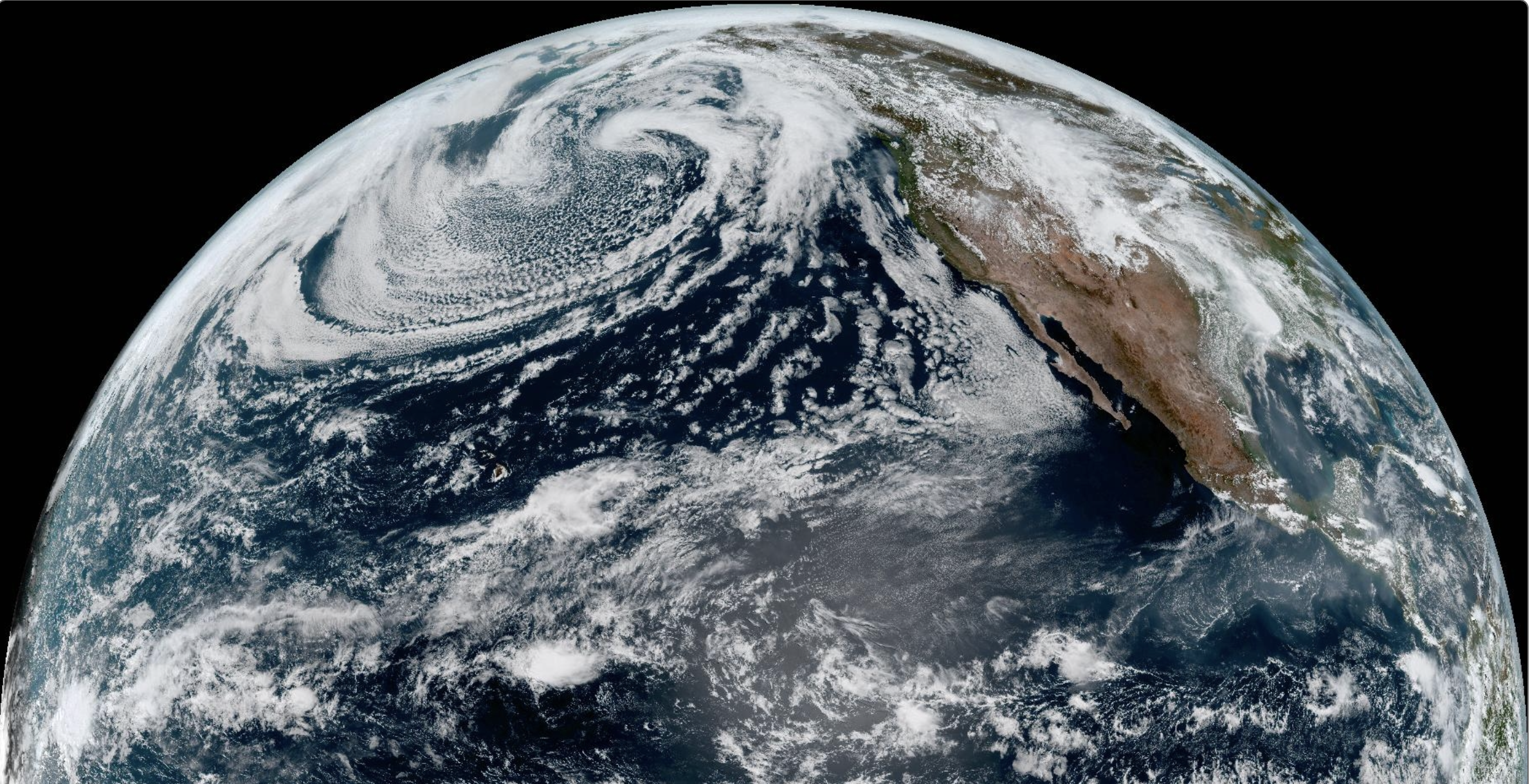
Warm ocean conditions are not just limited to the tropical Pacific. Despite some unusually cold ocean temperatures off the West Coast of the U.S., the remarkably warm global ocean has grabbed recent headlines.

For some additional perspective on this widespread warmth, I reached out to Dr. Boyin Huang, an oceanographer of the National Centers for Environmental Information with expertise in sea surface temperature reconstructions. Dr. Huang kindly provided the following of near-globally averaged sea surface temperature time series for two of our most used sea surface temperature datasets, monthly ERSSTv5 and daily OISSTv2.1.

First, we note that while the two datasets are not identical, both the ERSST and OISST datasets confirm that the global oceans are currently sizzling. However, they do have minor disagreements about record warmth. Although the global (non-polar) ocean surface temperatures have been warmer than at any point over the past 40 years in the OISST dataset since mid-March, the ERSST dataset has trailed the record warmth of 2016, at least until recently. However, Dr. Huang confirms a point of agreement: both datasets indicate that the global ocean surface was warmer in April 2023 than in any previous April.

How would a developing El Niño relate to the global ocean temperatures? First, global average temperature tends to be higher in El Niño years than in La Niña or ENSO-neutral years. Given how warm the oceans are already, a developing El Niño would only increase the chance of record-breaking global ocean temperatures (and global average temperature over both ocean and land), which likely would have important ecological consequences, including for fish and corals.

Another factor to consider is that the widespread ocean warmth may make it a little more challenging for the warm temperatures in the central-eastern equatorial Pacific to induce a tropical atmospheric response (maybe a reason for the current ENSO-neutral looking tropical atmosphere?). The reason is that the response of the tropical atmosphere depends on surface temperatures in the central-eastern equatorial Pacific relative to the surrounding regions. If those surrounding tropical regions are also warmer than average, then the bar is even higher for the Niño-3.4 region surface temperature anomalies to induce an atmospheric response.

The bottom line is that in terms of a push on the tropical atmosphere, we need to consider that the Niño-3.4 index may punch below its weight while it’s hovering in borderline El Niño territory, as it is now. However, if the central-eastern Pacific continues to warm up, we can expect that the atmosphere will feel that push eventually.

Coming Up

One of biggest implications of a developing El Niño in the shorter term is its potential influence on the Atlantic and Pacific hurricane seasons. In brief, Atlantic hurricane seasons tend to be less active during El Niño, while the Pacific season is often enhanced. That means this month’s ENSO forecast is likely one of the factors that will be considered in the hurricane outlook. In the meantime, keep your eyes peeled on the tropics, and don’t blink – conditions are evolving quickly.

In Summary:
  • One important factor of a building El Nino is warmer than average sea surface temperatures in the Nino 3.4 region (basically the tropical eastern Pacific)- which is occurring.
  • Another important factor is the atmosphere needs to be warmer than average in the Nino 3.4 region so storms can gather increased energy. Currently the atmosphere in that region is neutral- but heading towards El Nino conditions.
  • And for us here in Southern California, we'd like to see warmer than average water temperatures for a variety of reasons:
    • It would be nice to wear boardshorts right about now!
    • Less coastal clouds = more sunshine.
    • Really warm water off Baja results in major hurricanes results in good surf for us.
    • BUT... we've had constant WNW winds all winter/spring so our water temps are cooler than usual which is resulting in more clouds, fullsuits, and no chance of an early hurricane season unfortunately.
PIC OF THE WEEK:


One day, very soon, we'll see lines like this again. One day. (To see more waves of inspiration, check out Jerem'e Aubertin's website here).

Keep Surfing, 
Michael W. Glenn
Media Darling
Turned Down The Part Of 'Ken' In The New Barbie Movie
Taylor's Currently Filming Me At Seaside For Momentum IV

Thursday, May 18, 2023

THE Surf Report


Cold Water = Hot Waves

SURF:


I love it when we get a few days of swell around here and I act like all of those other months that were flat never happened. Great week for surf- if you didn't mind a little wind, colder than usual water temps, and overcast skies. 


Today we had a new overhead SW fill in with mostly walled conditions unless you surfed a reef, jetty, or point. For Friday into the weekend, the SW drops but still will be fun. We also get a slight bump from NW wind/groundswell late Saturday into Sunday. 


Sunday also sees another smaller SSW fill in. Long story, look for smaller shoulder high sets Friday, touch smaller Saturday, then fun combo swell on Sunday for more shoulder high sets. And here are the tides, sunrise/sunset, and water temps for the next few days:
  • Sunrise and sunset:
    • 5:47 AM sunrise 
    • 7:44 PM sunset 
  • Water temps unfortunately are still cool to cold with all the NW wind lately. Temps are low 60's at best.
    • For comparison's sake, we should be close to mid-60's by now while  the rest of the Pacific is above average AND we're headed towards El Nino. Something smells fishy...
  • And tides are extreme before sunrise and after sunset, but mellow midday:
    • almost -1' at sunrise
    • about 3' mid-day
    • 2' late afternoon
    • and up to 5' at sunset
FORECAST:


The combo swells from Sunday roll into Monday for more shoulder high surf- with the NW being more dominant. Tuesday looks to have mainly chest high sets from NW windswell towards SD. After that, things go quiet for awhile as the 2nd half of next week should be small. 


Next storm up could form this weekend off Antarctica and South America which would give us a straight shot of S swell towards the 28th- hopefully in the head high range again.

WEATHER:


Going to be honest here- not a big fan of spring. In particular- low clouds and fog. I either like it stormy or sunny. Fog is just so... boring. Until our water temps warm up, we're going to be stuck with this May Gray. Models indicate weak low pressure setting up the 2nd half of next week which will increase the depth of the marine layer- but I'm also hoping it may break up the clouds by at least late afternoon. Here's a quick rundown on the next 7 days:
  • Friday to Tuesday: Mostly cloudy. Temps 67/57
  • Wednesday to next weekend: Partly sunny. Temps... 67/57
If anything changes between now and then, make sure to follow North County Surf on Twitter!

BEST BET:

Friday with leftover SSW or Monday with fun combo swell.

NEWS OF THE WEEK:


As you know, San Diego County is no stranger to beach erosion. From the big cliff collapse at Blacks Beach this winter, to the train tracks in Del Mar perched precariously on the cliff, to the sand vanishing along most beaches this winter. But is the erosion happening faster than normal, slower than normal, or is it at a steady pace? I'll let Stanford researchers shed some light on the subject:

In parts of California's iconic mountainous coasts, breathtaking beauty is punctuated by brusque signs warning spectators to stay back from unstable cliffs. The dangers of coastal erosion are an all-too-familiar reality for the modern residents of these communities. Now, with a new tool, researchers are bringing historical perspective to the hotly debated topic of how to manage these disappearing coastlines.

Using a model that incorporates measurements of the amount of time coastal cliffs and their remnant deposits were exposed at the Earth's surface, Stanford researchers found that the rate of cliff erosion in the past 100 years is similar to that of the past 2,000 years. The proof-of-concept, published in the Journal of Geophysical Research: Earth Surface April 17, opens the possibility of using this new approach to understand the long-term history of coastal cliff erosion, or retreat, in other parts of the state. The work was conducted in Del Mar, California, a beach town in San Diego County with infrastructure atop its coastal bluffs.

"In this particular location, these cliff erosion rates have been the same for thousands of years, so we shouldn't expect them to get lower," said senior study author Jane Willenbring, an associate professor of Earth and planetary sciences at the Stanford Doerr School of Sustainability. "If anything, we should expect them to be higher in the future."

Del Mar is among locations that are critically important for understanding cliff retreat. Homes are situated up to 70 feet above its beach, in addition to public infrastructure. A major railroad between Los Angeles and San Diego runs atop the coastal bluffs, where cliff failures have resulted in several derailments in modern history, as well as rock fall events that led to closures in recent years.

"I think this study bolsters the thinking that we should do something about cliff retreat sooner rather than later," said lead study author Travis Clow, PhD '22.

A natural laboratory

The study area was ideal for the researchers' methodology because the Del Mar beach features a narrow shore platform, the bedrock where tidepools are typically found. Using nine samples of bedrock, the co-authors measured concentrations of the chemical isotope beryllium-10 that track landform exposure to cosmic radiation from space. The data were compared with cliff retreat rates from recent studies based on aerial photography, showing that coastal erosion rates have remained relatively constant over the past two millennia -- at about 2 to 5 inches per year.


"One of the advantages of this technique is that it gives you information at the time scales that are relevant for factors like sea-level rise," Willenbring said. "Our tool estimates retreat over time periods that include multiple major storms or atmospheric rivers that don't happen very often, but are critical in forming the coastline."

The researchers' approach explores the influence of different factors, including wave impacts and weathering that occur at the shore platform and the cliff interface.

"It does more than just spit out a retreat rate," said Clow, who processed the samples in Willenbring's lab and measured them at the Center for Accelerator Mass Spectrometry at Lawrence Livermore National Laboratory (LLNL). "It also allows us to have a relative assessment of what might be driving cliff retreat over longer periods of time."

When rock becomes air

On sandy coasts, like those spanning much of the eastern U.S., beaches are shaped by waves that pull sand out to the ocean, then re-deposit it on land with the coming and going of the tides. But with rocky coastlines like those along California, once a cliff erodes into the ocean, it cannot be replaced, Willenbring said. Instead, it's as if the rock becomes air.

Willenbring was surprised to learn through this research that over half of all coastlines on Earth are eroding like California's. The scope of the problem, which will be exacerbated by sea-level rise in the next century, presents an opportunity for using this new technique in other areas.

"There are plenty of other places in California and the Pacific Northwest where active erosion of coastal rocky cliffs is happening, and we hope to use this technique in a wide variety of environments," Clow said.

Knowledge of cliff retreat in the U.S. is about 50 years behind research on the impacts of erosion and storms on sandy beaches, according to Willenbring -- and that makes her excited about contributing to fundamental science in this field.

"No one had even looked at how the beach width correlated with the rate of cliff retreat in California," Willenbring said. "There are a lot of open questions about what drives coastal erosion, and now we have a new tool to be able to address some of them."

PIC OF THE WEEK:


Spring is here. Must be Wedge season. 

Keep Surfing, 
Michael W. Glenn
Witty
Finally Getting My Face On A Stamp
Developing An eSurfboard With Autopilot Feature. So If I'm Stuck At Work, At Least My Board Can Get Some Waves

Thursday, May 11, 2023

THE Surf Report


Normal Is The New Normal.

SURF:

After a winter of discontent, it's finally good to be back to normal around here. 


Fun waves, water temps approaching normal, the sun is shining- what more could you want? Today we had a good SSW swell filling in with a touch of NW windswell. Most spots are shoulder high with the OC going overhead on sets. That lasts into Saturday. Looks like I'll be turning on the ol' Emergency Boardriding System. Hope I don't jinx it like last time where the winds made a mess out of a perfectly good swell. 


For Sunday, today's SSW backs off but new small NW groundswell fills in along with a NEW SSW swell. Look for chest high+ surf most everywhere- and great weather. And here are the tides, sunrise/sunset, and water temps for the next few days:
  • Sunrise and sunset:
    • 5:51 AM sunrise (paddle out at 5:30 am?!)
    • 7:40 PM sunset (paddle in at 8 pm?!)
  • Water temps in So Cal are all over the place- 60 in LA, 62 in the OC, and up to 65 in La Jolla. BUT... Imperial Beach/Point Loma is 60! Beware...
  • And there's something for everyone with the tides this weekend:
    • 4' at sunrise
    • -0.5' mid-day
    • 4'5' at dinner
    • and down slightly to 3' at sunset
FORECAST:

The combo swells from Sunday roll into Monday for more shoulder high surf. 


Behind that is more shoulder high sets from the SSW late Tuesday. And beyond that? The Southern Hemisphere looks active- so possibly more good SSW the third week of May. Get it while you can 'cause you know how quick things change around here. Anyone remember February to April?...

WEATHER:


Great weather this week will lead to more great weather this weekend and beyond. High pressure is building slightly for more sunshine and temps in the low 70's along the coast. For next week, we have a sneak peak at monsoonal moisture heading our way for Tuesday/Wednesday. It will mostly be confined to the mountains, but cool to see those big thunderstorms in the distance during the late afternoons. Here's a quick rundown on the next 7 days:
  • Friday to Monday: Mostly sunny. Temps 70/60
  • Tuesday/Wednesday: More sun with a few thunderstorms in the mountains. Temps... 70/60
  • And the 2nd half of next week? More sun and temps 70/60.
If anything changes between now and then, make sure to follow North County Surf on Twitter!

BEST BET:

This weekend and most of next week. Stoke.

NEWS OF THE WEEK:


This weekend in weather history!

MAY 11
1997: Severe thunderstorms developed over Apple Valley and Hesperia during the afternoon, resulting in a tornado, dust storm, and downburst winds. The tornado was an F1 in Apple Valley that ripped up trees, knocked over fences and destroyed a shed. Shortly after the tornado, downburst winds ripped the roof from a home, downed utility lines, and blew off the camper shell from a truck. The intense winds also kicked up a dust storm that reduced visibility to 100 feet or less and mixed with precipitation to produce a muddy rain.

1987: Severe thunderstorms erupted across Southern California. The most intense storms hit areas between Perris and Mission Viejo with wind gusts to 62 mph and small hail. Heavy rains in the L.A. County Mountains produced debris flows between Littlerock and Pinon Hills that forced a closure of Highway 138.

MAY 12:
2014: A dust devil in Fullerton came abruptly out of the west with estimated wind gusts of 60 mph. It carried large amounts of dust and leaves, and damaged portions of roof shingles on a few homes.

2001: Downdraft winds from showers over the ridges accelerated down the north slopes of the San Bernardino Mountains into Apple Valley, where wind gusts to 62 mph and blowing dust with near zero visibility were observed. A wind gust of 82 mph occurred at Granite Mountain, just north of Apple Valley.

1998: El Niño’s last gasp brought rare rain to San Diego and rained out the Padres’ home game against the New York Mets at Qualcomm Stadium. This was the first rainout in over 15 years (since 4/20/1983).

MAY 13:
2014: Strong high pressure and a strong late-season Santa Ana wind event combined to bring record high temperatures exceeding 100° to most of the lower elevations from this day to 5/15. Many all-time high temperature records for the month of May were broken. On this day temperatures soared into the 90s across the region. The hottest day was 5/15 when it was 106° in Yorba Linda and the San Diego Wild Animal Park. The strong Santa Ana winds gusted to 40 to 45 mph in parts of the coast and valleys, and 60 to 80 mph in the foothills. The winds knocked down many trees and power lines, and blew off some roof tiles. Numerous fires erupted especially in San Diego County, burning over 27,000 acres and causing more than $50 million in property damage. The Poinsettia fire in Carlsbad and the Cocos Fire in San Marcos damaged homes, but no serious injuries or deaths resulted.

1999: Strong sustained winds of 61 mph were measured at Borrego Springs, causing roof and tree damage.

1998: An unseasonably strong trough of low pressure swept through Southern California. Thunderstorms over the Inland Empire produced several funnel cloud reports and at least one tornado (F0). The tornado touched down in Homeland ripping awnings from several trailers. Funnel clouds were observed in Homeland as well and in Moreno Valley. It rained 1.14 inches in Santa Ana, the greatest daily total on record for May. Snow fell as low as 4,000 feet with six inches reported at 5,800 feet and up to two feet at resort level. 7.9 inches of snow fell in Big Bear Lake, the greatest daily snowfall on record for May. Multiple ski resorts reopened.

1989: Dense fog along Interstate 8 near Pine Valley contributed to a series of chain reaction accidents. 31 people were injured, with five suffering serious injuries.

MAY 14:
2015: A strong late-season winter storm, along with some thunderstorms, hit the region. San Diego reported 1.30 inches of rain in one hour. A nine-minute period within that main hour totaled 0.71 inch, which is near the 1/100 return interval. The amount of 1.63 inches on this day broke the daily rainfall record for any day in May. Flooding in Mission Hills and Midway District of San Diego was up to four feet deep. Several swift water rescues were made for people trapped in flooded vehicles.

2014: Strong high pressure and a strong late-season Santa Ana wind event combined to bring record high temperatures exceeding 100° to most of the lower elevations from 5/13 to 5/15. Many all-time high temperature records for the month of May were broken. On this day temperatures soared into the 100s across the region. The hottest day was 5/15 when it was 106° in Yorba Linda and the San Diego Wild Animal Park. The strong Santa Ana winds gusted to 40 to 45 mph in parts of the coast and valleys, and 60 to 80 mph in the foothills. The winds knocked down many trees and power lines, and blew off some roof tiles. 14 fires erupted in San Diego County, killing one, burning over 27,000 acres and causing more than $50 million in property damage. The Poinsettia fire in Carlsbad and the Cocos Fire in San Marcos damaged homes.

1918: The temperature dropped to 30° in Victorville, tied for the second coldest night in May during a long cold spell.

BEST OF THE BLOG:


Thanks again to all of our sponsors for tomorrow's charity golf tournament! Sponsored by our friends at Venture LLP, we're benefiting the Carlsbad Educational Foundation and are looking at a full day of activities. Here's a quick rundown on the schedule for Friday:
  • 7-7:30 AM check in
  • 7:45 AM word from Goat Hill
  • 8 AM play ball! 
  • 12:30 PM lunch/awards/auction
Thanks to everyone who is participating and we'll see you at Goat Hill tomorrow!

PIC OF THE WEEK:


Who has better surf? The Northern Hemisphere or the Southern Hemisphere? Take your pick: Pipeline vs. Teahupoo. Trestles vs. Snapper. G-land vs. Mundaka. Mavericks vs. Dungeons. Here's New Zealand putting up a good fight vs. Ireland. 

Keep Surfing, 
Michael W. Glenn
A Cut Above The Rest
Still In London Partying With Charles
Pipe(s) Master (The Wave In Cardiff- Not Oahu)

Thursday, May 4, 2023

THE Surf Report


Up vs. Down

SURF:


It's been Ying and Yang around here this spring. Rain vs. sun. Clean vs. windy. East coast windswell vs. California groundswell. Occy vs. Curren. Looks the rain will exit tomorrow and we're back to May Gray- along with a new SW groundswell. 


You've probably heard about the 'Code Red' swell in Tahiti earlier this week. We'll get some of that- but only a shell of it's former self. Buoys tonight are seeing new 20 second readings from the building swell and by tomorrow afternoon we should have shoulder high sets in N County SD with head high surf in the OC. By Saturday, the SW peaks with head high sets in N SD and overhead surf in the OC- along with a touch of NW windswell. Sunday has some fun leftover waves. And here are the tides, sunrise/sunset, and water temps for the next few days:
  • Sunrise and sunset:
    • 5:56 AM sunrise
    • 7:35 PM sunset
  • Water temps in So Cal are hanging on to 62 and surrounded by high 50's in the outer waters. 
  • And tides for this weekend:
    • -1' at sunrise
    • 3.5' late morning
    • down to 1.5' late afternoon
    • and up to 4' at sunset
FORECAST:

Good news is that we have more surf coming. Bad news is that there could be another weak front moving through next week. Winter just won't give up. 


First up is more chest high NW on Monday/Tuesday from the cold front mentioned above. 


Behind it is fun chest high S next Friday the 12th- and clean conditions? 


If models are correct, we'll see chest high NW groundswell next weekend in SD too, then more chest high SW towards the 20th. What I'm hoping to see is less wind and more swells the next 10 days...

WEATHER:


Not the biggest storm today but still impressive to see a dusting of snow in the local mountains in May. Most spots along the coast received up to 1/4" and cool breezy conditions. High pressure is nowhere to be found unfortunately so look for more clouds this weekend and maybe more wind towards Tuesday (and showers)? THEN... maybe sun the 2nd half of next week. Here's a quick rundown on the next 7 days:
  • Friday: Cloudy and cool. Temps 60/55
  • Saturday: A touch of sun in the afternoon. Temps- see above.
  • Sunday: see above
  • Monday: see above
  • Tuesday: More extensive clouds, breezy, & sprinkles? Temps (see above)
  • Wednesday: Transition day. Temps (see above)
  • Hopefully more sun towards Thursday through next weekend. 
If anything changes between now and then, make sure to follow North County Surf on Twitter!

BEST BET:

Good SW Friday/Saturday or slightly smaller surf next week from a variety of sources.

NEWS OF THE WEEK:


Been more than enough June Gloom to start the spring. Or is it called Graypril in April? Or May Gray in.. well, you get the point. Whatever you call it, the common term is the 'marine layer'. So why is it so darn persistent this time of year? Would be nice to see some sun here and there. Here's the National Weather Service to explain:

We are in the thick of Graypril/May Gray, but have you ever wondered why it is so prevalent this time of year? Time for a little weather education. An area of high pressure becomes anchored over the eastern Pacific, creating (generally) prevailing northwest winds. Cool waters from the Gulf of Alaska pull cold water down the coast. Water temps are currently in the upper-50s in the outer waters and low 60s along the shoreline, quite chilly!

As the sun angle gets higher and seasonal temperatures increase, there is contrast between the cool, marine-influenced air near the surface & by the coast, versus the warmer temperatures inland & above the surface. This creates a temperature inversion.

When the air aloft is very hot, this creates a strong temp inversion, which essentially squishes the humid marine air, resulting in a shallow marine layer and clouds remain more confined to the coast. When the temperature inversion is weaker, clouds extend farther inland.

As we progress into the summer months, the ocean temperatures rise, resulting in warmer coastal temperatures. So, the inversion becomes weaker, and the low clouds and fog aren't quite as prevalent in July/August.

For this weekend, low clouds and patchy fog are expected each night and morning, but most areas away from the beaches should see clearing by late morning. We are definitely in the peak of marine layer season unfortunately. And if the darn El Nino would finally show up, we'd have less clouds!

BEST OF THE BLOG:


WANTED TO GIVE A BIG SHOUT OUT TO ALL OUR PLAYERS AND SPONSORS FOR NEXT FRIDAY'S CHARITY GOLF TOURNAMENT! Sponsored by our friends at Venture LLP, we're benefiting the Carlsbad Educational Foundation and are SOLD OUT for hole sponsorships and have just a couple spots available to play. So if you've been draggin' your feet and are looking for a good excuse to start the weekend off right as well as help your community, reach out ASAP to Rich Clark at rich@logicopy.com or Michael Glenn at northcountyboardmeeting@gmail.com. Thanks supporting the North County Board Meeting and we'll see you at Goat Hill next Friday, May 12th!

PIC OF THE WEEK:


I'd like to build a home on this point when I retire. Like, tomorrow. 

Keep Surfing, 
Michael W. Glenn
A Who's Who
May The 4th Be With Me 
Only Surfer To Make The Covers of ESM, Zigzag, Surfing Life, Surfer, SW, Freesurf, Surfing, TransWorld Surf, Breakout, Stab, Heavywater, Tracks, Wavelength, and Water Magazines