Friday, February 26, 2021

THE Surf Report


February is a distant memory. 

SURF:
Remember all that great surf we had way back in February? That was like what- 3 or 4 months ago it seems? Good times. 


This past week saw some nice weather but only waist high+ NW with a touch of SW. 


This weekend we get a small bump of NW windswell late Saturday for chest high waves but a weak cold front moving by to the N may make it a little bumpy in the afternoon. For Sunday, the NW will be dropping but offshore winds are forecasted in the AM. My take? Get it early Sunday. Here's the tide, sun, and water temps for you:
  • Sunrise and sunset are giving us almost 12 hours of surfing time:
    • 6:18 AM sunrise (crack it at 6 AM!)
    • 5:45 PM sunset (paddle in at 6 PM!)
  • Water temps are 58 and feel colder than that
  • And tides are extreme this weekend:
    • 4' at sunrise
    • 6' mid-morning
    • -1' late afternoon
    • 1' at sunset
FORECAST:


Not much to start the work/school week as we've just got waist high SW for Monday/Tuesday and a couple better waves in the OC. 


Wednesday, another weak front moves to the N of us and we'll be back to chest high NW surf late Wednesday and breezy afternoon winds. What does that mean for Thursday? You guessed it- dropping NW swell and offshore conditions. 


BUT... models showed a better S swell taking shape a couple days ago which would give us chest high sets on Thursday too. After that, the Pacific seems to doze off so next weekend may be small again. 

BEST BET: 
Sunday morning with small but clean NW or late next Wednesday/early Thursday with more NW and better SW. 

WEATHER:


If you haven't guessed already, this is turning out to be one of the driest February on records. Not a big fan of watering my lawn in the middle of winter. It's like wearing a jacket in San Diego in August. Inconceivable! As mentioned above, we have a weak cold front moving by to the N on Saturday which will kick up the winds at the coast in the 20 MPH range and a little more clouds overhead. Sunday and into early next week we'll have sunny skies and temps in the high 60's. Another weak front makes its way into Northern California on Wednesday and we get more winds/clouds down here and cooler temps; forecast charts do show a small chance of light showers but don't get excited. And the 2nd half of next week? More sun and mild temps. Make sure to check out Twitter/North County Surf if anything changes between now and then. 

NEWS OF THE WEEK: 


I know we should feel fortunate that we're not dealing with floods or freezing temps, but I'm not a big fan of wildfires either. This La Nina is really kicking our butts. As it stands now, models are showing that we've only got a 20% chance of getting us back to our average of 10" of rain for the winter. But anything can happen of course. 


Don't forget April 11th last year when a storm capped a six-day period that brought tremendous amounts of rain to the region. Palomar Mountain received at least 8.40 inches of rain while more than 7 inches fell in Encinitas, and 3.5 inches hit San Diego International Airport. That's unlikely of course, but you never know in this wacky world. So where do we stand as of today for precipitation?
  • Newport Beach: 3.23" of rain or 34% of normal (9.63") and we're aiming for a seasonal total of 13.3"
  • Oceanside: 3.31" of rain or 36% of normal (9.27") and we're aiming for a seasonal total of 13.66"
  • San Diego: 2.88" of rain or 40% of normal (7.12") and we're aiming for a seasonal total of 10.34"

But it's still winter around here- why do we only have a 20% chance of getting back to our normal seasonal rainfall target? Well unfortunately, our 3 wettest months should be January, February, and March with around 2.25" each month. Since January and February are in the rearview mirror, that leaves March to do all the work and that's asking a lot. By the time we hit April, we won't see over an inch of rain on average until November. Long story short- start conserving water now. 

PIC OF THE WEEK:


I know everyone has been anxiously waiting for Disneyland to re-open and rightfully so- who doesn't love the Dumbo ride, seeing a goat with dynamite in it's mouth on Big Thunder Mountain Railroad, those yummy churros, and families in matching outfits. But let's be honest- THIS is the happiest place on earth. And no Fast Pass required. 

Keep Surfing,

Michael W. Glenn
I've Arrived
Working On Getting Kim & Kanye Back Together
Chairman Of My Board

Thursday, February 18, 2021

THE Surf Report- Early Edition


Pinch me, I must be dreaming. 

SURF:


Wait- I was kidding! Oh well. Our current run of dream surf may be in the rearview mirror, but fear not, we still have rideable waves for the weekend. For Friday, the fun SW that peaked yesterday will have leftover chest high surf in far north county SD and the OC. Look for light offshores in the AM and NW winds in the afternoon too. 


Then there's a weak cold front moving by to the N on Saturday which will kick up the NW windswell late Saturday into Sunday for head high sets. All in all, Friday will be the cleanest but late Saturday/early Sunday will be slightly bigger but not as clean. Here's the tide, sun, and water temps for ya:
  • Sunrise and sunset are getting farther apart...
    • 6:27 AM sunrise
    • 5:37 PM sunset
  • Water temps have inched up to 58! 
  • And tides are boring this weekend:
    • 3' at sunrise
    • 1' at lunch
    • 2' at sunset
FORECAST:


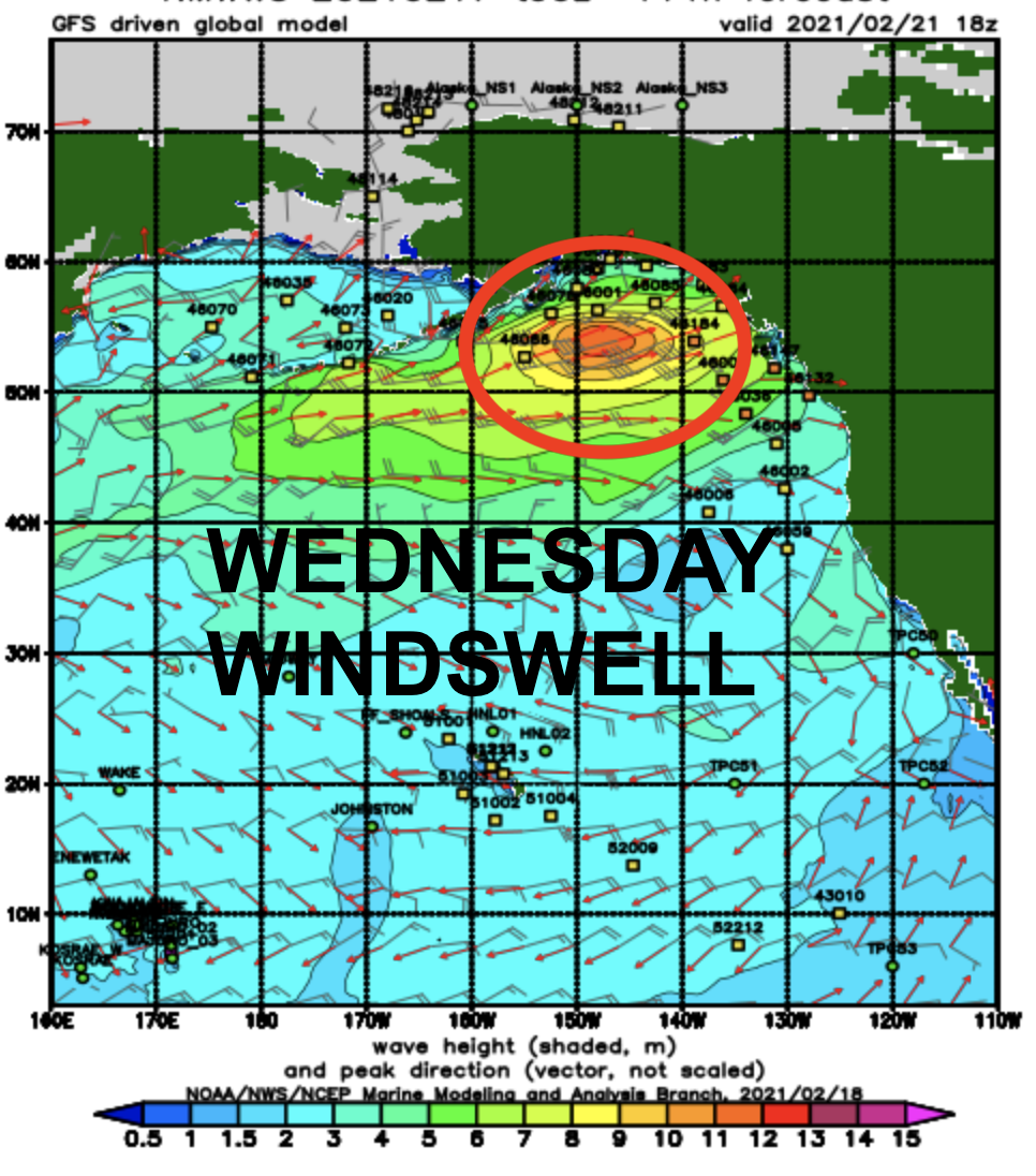
The Pacific is hibernating next week as we've just got minor NW wind/groundswell for Wednesday and waist high+ surf. 


After that, charts show a storm getting it's act together off Antarctica today which would give us chest high+ SW around the 26th. And that's about it. Know of any good wavepools around here?

BEST BET: 
Next weekend with small but fun SW. 

WEATHER:


While the Pacific Northwest has been getting drenched, we've been getting the desert treatment down here. Under 3" of rain this season in San Diego (about 40% of normal) with plenty of sunny skies; expect the same for at least the next 7 days. Tomorrow we've got 1 more day of high pressure for temps in the mid 60's then a weak front moves by to the N of us on Saturday for a little more clouds that will be slow to burn off. Sunday and Monday are warm again with temps near 70 and then another weak front moves by to the N on Tuesday for cooler temps again. Models HINT at maybe showers late next weekend so we'll have to see. Make sure to check out Twitter/North County Surf if anything changes between now and then. 

NEWS OF THE WEEK: 


Researchers recently drilled through a 1/2 mile thick Antarctic ice shelf to sample sediment. Instead, they found animals that weren't supposed to be there. Just when you thought there's nothing left to discover here on Earth. Here's Wired Magazine with the story:

In the middle of the Filchner-Ronne Ice Shelf—a five-hour flight from the nearest Antarctic station—nothing comes easy. Even though it was the southern summer, geologist James Smith of the British Antarctic Survey endured nearly three months of freezing temperatures, sleeping in a tent, and eating dehydrated food. The science itself was a hassle: To study the history of the floating shelf, he needed seafloor sediment, which was locked under a half mile of ice. To get to it, Smith and his colleagues had to melt 20 tons of snow to create 20,000 liters of hot water, which they then pumped through a pipe lowered down a borehole. It took them 20 hours to melt through the ice inch by inch, finally piercing through the shelf. Next, they lowered an instrument to collect the sediment, along with a GoPro camera. But the collector came back empty. They tried once more. Still empty. Again, nothing comes easy here: Each round trip of the instrument took an hour.

Later that night in his tent, Smith watched the footage and recognized a rather glaring problem. The video shows a descent through 3,000 feet of blue-green ice, which suddenly terminates, opening up into dark seawater. The camera coasts another 1,600 feet until the seafloor finally comes into view—mostly light-colored sediment, which Smith was after, but also something dark. That dark thing turned out to be a rock, which the camera hits with a thud, tumbling face-down into the sediment. The camera quickly rights itself and scans the rock, revealing something the geologists hadn’t been after at all. In fact, it was something highly improbable: life.

“It’s like, bloody hell!” Smith says. “It's just one big boulder in the middle of a relatively flat seafloor. It’s not as if the seafloor is littered with these things.” Just his luck to drill in the only wrong place. Wrong place for collecting seafloor muck, but the absolute right place for a one-in-a-million shot at finding life in an environment that scientists didn’t reckon could support much of it. Smith is no biologist, but his colleague, Huw Griffiths of the British Antarctic Survey, is. When Griffiths watched the footage back in the UK, he noticed a kind of film on the rock, likely a layer of bacteria known as a microbial mat. An alien-like sponge and other stalked animals dangled from the rock, while stouter, cylindrical sponges hugged the surface. The rock was also lined with wispy filaments, perhaps a component of the bacterial mats, or perhaps a peculiar animal known as a hydroid.

The rock Smith had accidentally discovered is 160 miles from daylight—that is, the nearest edge of the shelf, where ice ends and the open ocean begins. It’s hundreds of miles from the nearest location that might be a source of food—a spot that would have enough sunlight to fuel an ecosystem, and be in the right position relative to the rock for known currents to supply these creatures with sustenance. Not to tell life its business, but it’s got no right being here. “It's not the most exciting-looking rock—if you don't know where it is,” says Griffiths, lead author of a new study published in the journal Frontiers in Marine Science. Since you now do know, then it means your jaw may be somewhere near the floor right about now.


We can say for certain that these animals are living in total darkness, which is fine—plenty of deep-sea critters do the same. But animals that live sessile (read: stuck in place) existences on the deep sea floor must rely on a fairly steady supply of food in the form of “marine snow.” Every living thing swimming in the water column above must one day die, and when they do, they sink to the depths. As the corpses descend and decompose, other creatures pick at them and fling off particles, tiny morsels that accumulate even on the deepest of seafloors. (When a whale dies and sinks, by the way, it’s epically known as a “whale fall.”)

This works in most parts around Antarctica, where the waters are incredibly productive. Tiny critters known as plankton feed all kinds of fish, which feed large marine mammals like seals. All this activity produces detritus—and dead animals—that one day become marine snow. But the Antarctic critters on this particular rock don’t live under a bustling water column. They live under a half-mile of solid ice. And they can’t roam away from their rock in search of food. “The worst thing in a place where there's not much food, and it's very sporadic, is to be something that's glued to the spot,” says Griffiths. So how on Earth could they be getting sustenance?

The researchers think it’s likely that the drift of this marine snow has been flipped on its side, so that the food source is moving horizontally instead of vertically. Looking at charts of currents near the drill site, the researchers determined that there are productive regions between 390 and 930 miles away. It may not be much, but it’s possible that enough organic material is riding these currents hundreds of miles to feed these creatures. That’s an extraordinary distance, given that in the deepest part of the ocean, the Challenger Deep near Guam, marine snow produced at the surface has to fall 7 miles down to reach the seafloor. To reach the animals on this Antarctic rock, food would have to travel as much as 133 times that distance—and it would have to do so by floating sideways.

Given what scientists know about currents around Antarctica, this isn’t particularly far-fetched, says Rich Mooi, curator of invertebrate zoology and geology at the California Academy of Sciences, who has studied Antarctic sea life but wasn’t involved in this new work. As seawater cools in the region, it grows more dense. “It sinks to the sea bottom and pushes water outward, radiating outward from the Antarctic,” says Mooi. “And these currents are actually the germ of many—if not almost all of—the current systems on the planet.” As that water pushes outward, something has to fill the void. “There's going to be some inflow to replace that,” Mooi adds. “And that inflow, even over hundreds of kilometers, is going to carry organic matter.” For our lifeforms stuck on that boulder, this would bring food. The currents could also bring new animals to add to the population on the rock.


But because the researchers couldn’t collect specimens, they can’t yet say what exactly these sponges and other critters could be eating. Some sponges filter organic detritus from the water, whereas others are carnivorous, feasting on tiny animals. “That would be sort of your headline of the year,” says Christopher Mah, a marine biologist at the Smithsonian, who wasn’t involved in the research. “Killer Sponges, Living in the Dark, Cold Recesses of Antarctica, Where No Life Can Survive.” And Griffiths and his team also can’t yet say if mobile creatures like fish and crustaceans also live around the rock—the camera didn’t glimpse any—so it’s not clear if the sessile animals face some kind of predation. “Are they all eating the same food source?” asks Griffiths. “Or are some of them kind of getting nutrients from each other? Or are there more mobile animals around somehow providing food for this community?” These are all questions only another expedition can answer.

It does appear that sedimentation around the rock isn’t very heavy, meaning the animals aren’t in danger of being buried. “It's kind of a Goldilocks-type thing going on,” says Griffiths of the rock’s apparently fortuitous location, “where it's got just enough food coming in, and it's got nothing that wants to eat them—as far as we can tell—and it’s not getting buried by too much sediment.” (In the sediment surrounding the rock, the researchers also noticed ripples that are typically formed by currents, thus bolstering the theory that food is being carried here from afar.)

It’s also not clear how these stationary animals got there in the first place. “Was it something very local, where they kind of hopped from local boulder to local boulder?” asks Griffiths. Alternatively, perhaps their parents lived on a rock hundreds of miles away—where the ice shelf ends and more typical marine ecosystems begin—and released their sperm and eggs to travel in the currents. Because Griffiths and his colleagues don’t have specimens, they also can’t say how old these animals are. Antarctic sponges have been known to live for thousands of years, so it’s possible that this is a truly ancient ecosystem. Perhaps the rock was seeded with life long ago, but currents have also refreshed it with additional life over the millennia.

The researchers also can’t say whether this rock is an aberration, or if such ecosystems are actually common under the ice. Maybe the geologists didn’t just get extremely lucky when they dropped their camera onto the rock—maybe these animal communities are a regular feature of the seafloor beneath Antarctica’s ice shelves. There’d certainly be a lot of room for such ecosystems: These floating ice shelves stretch for 560,000 square miles. Yet, through previous boreholes, scientists have only explored an area underneath them equal to the size of a tennis court. So it may well be that they’re out there in numbers, and we just haven’t found them yet. And we may be running out of time to do so. This rock may be locked away under a half mile of ice, but that ice is increasingly imperiled on a warming planet. “There is a potential that some of these big ice shelves in the future could collapse,” says Griffiths, “and we could lose a unique ecosystem.”

BEST OF THE BLOG:


Now that working from home is the new norm, isn't it time you livened up those 4 walls? And I'm not talking about going to Home Depot, standing in line at the paint counter for 30 minutes, taping off your home office, spilling paint on the carpet, and then realizing the color wasn't exactly what you thought. No, I'm talking about something simpler- just visit F Stop Blues, choose an image from your favorite photographers (that's me and my son Alex in case you were wondering), and the next thing you know, you're hanging a beautiful canvas print on your wall and your home value just went up $100,000 (specific results may vary). 


With plenty of prints from your favorite places across this great land of ours- like Encnitas, Yosemite, Big Sur, Eastern Sierras, Yellowstone, the Pacific Northwest, our local deserts, Grand Tetons, and more- you'll be longing to blow off that Zoom meeting and get outside! And for friends of THE Surf Report, use code TSR10 at checkout to receive 10% off your purchase. But hurry as this deal only lasts until February 28th. Visit F Stop Blues today! 

PIC OF THE WEEK:

The following surf spot is in:
  1. New Zealand
  2. Pacific Northwest
  3. Nova Scotia
  4. Lake Tahoe
  5. None of the above
First person to guess correctly gets... nothing. Secret spots shall remain secret. 

Keep Surfing,

Michael W. Glenn
Destined For Greatness
Had A Bender With Ted Last Night At Club Med Cancun
Surfline's Wave Of The Winter '92

Thursday, February 11, 2021

THE Surf Report- Early Edition


How much longer La Nina?

SURF:
After the firing surf and great weather in January, La Nina has finally taken hold in February. 


Not much surf this past week but things will pick up in the next 7+ days. For Friday we have a weak cold front moving through which will give us chest high+ NW wind/groundswell and some NW winds unfortunately. Saturday morning the swell hangs around the winds back off. 


Then... another cold front moves through Saturday evening into Sunday morning with overhead windswell and NW winds again. So look for waves but wind this weekend. Here's the tide, sun, and water temps for you diehards:
  • Sunrise and sunset are exactly 11 hours apart! (not sure that means anything):
    • 6:33 AM sunrise
    • 5:33 PM sunset
  • Water temps are still hanging around 57.  
  • And we've got a fairly big tide swing mid-morning through late afternoon:
    • 3' at sunrise
    • 6' mid-morning
    • -0.5' late afternoon
    • 1' at sunset
FORECAST:
After a bumpy weekend, forecast charts show another potential cold front moving through on Tuesday BUT... we have good surf coming. Hopefully the good outweighs the bad. So I'm taking a gamble here and firing up the Emergency Boardriding System. Jinx! 


First up is a new S swell that took shape a couple days ago off Antarctica. Look for chest high swell from that one in north county SD on Tuesday. 


Later that day, we also have new shoulder high NW arriving. Both swells will light up a lot of spots for head high+ surf into Wednesday morning. The NW backs off by Thursday but the S swell gets another reinforcement- so look for shoulder high sets towards north county SD into the OC. After that, the Pacific slows down slightly but we may see more chest high NW/SW next weekend. Make sure to check out Twitter/North County Surf if anything changes between now and then. 

BEST BET: 
Wind waves this weekend if you must or good combo swell Tuesday through Thursday (so basically Tuesday through Thursday). 

WEATHER:


What looked promising for rain a few days ago is now turning out to be just a chance of showers and breezy on Friday and 1/10" of measurable precipitation at best along the coast. Saturday night's cold front was also downgraded to just some wind and not much else. So that's pretty much La Nina in a nutshell. Models show another weak cold front coming through on Tuesday and the 2nd half of next week should be cool and clear. 

NEWS OF THE WEEK: 


The benefits of La Nina is that storms in the Pacific form off Japan, hit high pressure above Hawaii, and get pushed into Canada. The result? Good surf for us and sunny skies. The bad of course is the lack of rain we desperately need in Southern California. So when do we expect our weather systems to get back to normal in the Pacific? The National Oceanic and Atmospheric Administration can help answer that:

La Niña is still here of course, but forecasters estimate about a 60% chance that neutral conditions will return this spring. By the fall, the chance that La Niña will return is approximately equal to the chance that it will not. 

The temperature of the ocean surface in the western equatorial region of the tropical Pacific, our primary El Niño/Southern Oscillation (ENSO) measurement, was just about 1.0°C (1.9°F) below the long-term average in January, according to the ERSSTv5 dataset. As of this month, the long-term average is calculated over 1991–2020. Of course, ENSO wouldn’t be ENSO without the coupling between the ocean and the atmosphere. In January, La Niña’s expected relationship—cooler-than-average ocean surface and a stronger-than-average Walker circulation—was clearly going hot and heavy. Evidence of this was provided by more rain and clouds over Indonesia and less over the central Pacific, stronger west-to-east winds aloft, and stronger east-to-west winds near the surface of the equatorial Pacific.


Although comfortably exceeding the La Niña threshold of more than 0.5°C cooler than average, the January index moved closer to average from December. Forecasters think this tendency will continue, and they estimate there’s about a 60% chance the index will move into neutral territory by April–June. The next most likely scenario—the remaining 40%—is a continuation of La Niña through the spring. What happens next fall is less clear. There is a wide range of possible outcomes shown by the computer model forecasts, but we’re getting into the spring predictability barrier, a time of year when model forecasts are less reliable. By the fall, chances of La Niña are about 50%, with approximately 40% chance of neutral and 10% chance of El Niño.

So what does this mean for us? Hopefully our water will warm up to normal levels this spring and hurricane surf will be at least average again. Phasing out La Nina this spring to a neutral pattern won't do much to our rainfall potential because we're pretty much out of our rainy season by May anyway. As far as the forecast for summer and fall goes, it would be great if there was a trend towards El Nino (warm water and above average hurricane surf), but as described above, we may be headed towards another La Nina. Not as strong as this one fortunately- but maybe a below average winter next year when it comes to rain? Hope not. 

PIC OF THE WEEK:


What's more ominous? The cloudy island in the background or the eerily empty lineup? Who cares- you only live once- I'm out there! 

Keep Surfing,

Michael W. Glenn
Glass Half Full Kinda Guy
Unpaid Stuntman
Wanted A Board With Rocker So My Shaper Had Dee Snyder Deliver It

Thursday, February 4, 2021

THE Surf Report- Early Edition


Poof! 

SURF:
And just like that- winter is gone. 


Great surf the first half of January was replaced by stormy conditions at the end of January. Now that February is here... poof! Surf and storms are gone. But we do have nice weather. So what's in store for the weekend? Not much. 


We have leftover waist high NW windswell for Friday/Saturday and waist high+ W swell for Sunday with chest high sets in SD. Here's the tide, sun, and water temps if you must paddle out:
  • Sunrise and sunset:
    • 6:39 AM sunrise
    • 5:26 PM sunset
  • Water temps are still hanging around 57. And don't expect mid-60's until at least May. 
  • And tides aren't doing much this weekend:
    • 4' at sunrise
    • -0.5' at lunch
    • 3' at sunset
FORECAST:
What looked promising on the charts last week, is now looking on the small side for next week. 


We've got leftover waist high W swell for Monday/Tuesday and we get a small increase in NW swell late Wednesday into Thursday. Look for chest high surf that lasts into Friday morning. 


After that, forecast charts show a storm taking shape this weekend in the southern hemisphere that should give us chest high S swell around the 16th. 


And there's a possibility the northern hemisphere may come to life again next week too which may give us good NW swell again mid-month. Make sure to check out Twitter/North County Surf if anything changes between now and then. 

BEST BET: 
Looks like Thursday with chest high sets from the W or next weekend with small but fun S swell. 

WEATHER:


Our rain looks to be done for the near future so enjoy the sunny skies this weekend! High pressure will be in charge for Friday/Saturday with temps in the mid to high 60's at the beaches. Low clouds/fog return in the nights/mornings next week and that's all she wrote.  

NEWS OF THE WEEK: 


While we wait for rain to magically fall from the heavens again, here's what real weather looks like from this day in history...
  • 2009: A strong cold front produced heavy rain across Southern California starting on this day until 2/10. Two inches fell near the coast and up to six inches fell in the foothills. On this day flash flooding occurred near La Habra Heights. One foot of water flooded Highway 60 near the Hacienda exit. 
  • 1992: A series of many intense storms started on this day and ended on 2/16. The storms brought a total of more than 20 inches of precipitation to the mountains and eight to more than 16 inches to lower elevations. Two were killed in an avalanche at Mt. Baldy. Flash flooding, mud slides, and road closures also occurred. 
  • 1980: This was the start of nine consecutive days (the most on record) of measurable precipitation in San Diego, which ended on 2/13. This also occurred on 2/26-3/6/1983 and 2/13-2/21/1980. 
  • 1976: Strong storm winds hit 64 mph at Palmdale. 
  • 1969: A waterspout was observed off the coast of San Diego. 
  • 1948: Steady rain and mountain snow hit Southern California after a long dry spell. San Bernardino recorded 2.14 inches from this storm. Only 5.75 inches had been recorded before this storm in the previous year. 
  • 1937: A storm that started on 2/4 and ended 2/7 dropped over 10 inches at Cuyamaca, 8.20 inches in Descanso, and 5.70 inches in Escondido. On 2/6 and 2/7, 4.25 inches fell in Long Beach, a 24-hr record. Flooding kills several. LA basin was flooded in many communities. Hodges Dam overtopped. Mountain snowmelt added to the flooding. 
  • 1905: Heavy rains from 2/4 to 2/6 caused the San Diego River to run for the first time in six years. 4.23 inches fell in San Diego in 43 hours.
PIC OF THE WEEK:


FINALLY! A pointbreak that has something for regularfoots AND goofyfoots. 

Keep Surfing,

Michael W. Glenn
In My Prime
Amazon's 2nd Choice To Replace Bezos
Guiness Record Holder- Rode World's Smallest Surfboard: 2'10"