Thursday, February 29, 2024

THE Surf Report


SURF:


'Tis the time of year we start seeing building SW swells, windy storms, and a bit warmer temps. Spring must be around the corner as evident by the sun this week and fun combo swells. For tomorrow, surf stays tiny as we wait for our next storm. 


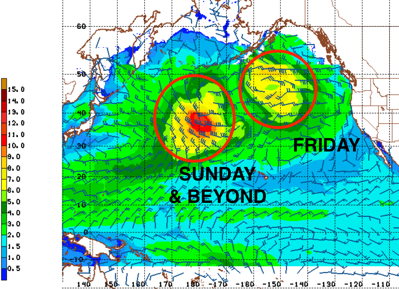
Saturday starts to build in the head high range from the NW with a touch of new SW- but things will be a mess as low pressure moves through with wind and rain. On Sunday, the sun emerges but we may have NW wind behind the cold front while the NW swell holds in the head high range. All in all- some surf this weekend- but bumpy. And here’s the sun, tides, and water temps for the upcoming weekend:
  • Sunrise and sunset:
    • 6:13 AM sunrise
    • 5:48 PM sunset 
  • Water temps are hovering around 60 +/-
  • And not much in the way of tides this weekend:
    • about 2' at sunrise
    • drops slightly to 1' mid-morning
    • and up to 4.5' at sunset
FORECAST:

As was the case last winter, high pressure will fill in after our cold storm this weekend, but it will let storms in the near future slide down the coast from the N. As they do, we'll see more windy days and short interval NW swell. 


The beginning of the week looks to be sunny with small dropping NW then we have more suspect conditions by Thursday and an increase in chest high NW windswell. 


We also have a small S swell marching our way- but it will meet the junky conditions later in the week. Further out, we could see more windy NW chest high surf & showers towards late Sunday the 10th. If anything changes between now and then, make sure to follow North County Surf on Twitter

WEATHER:


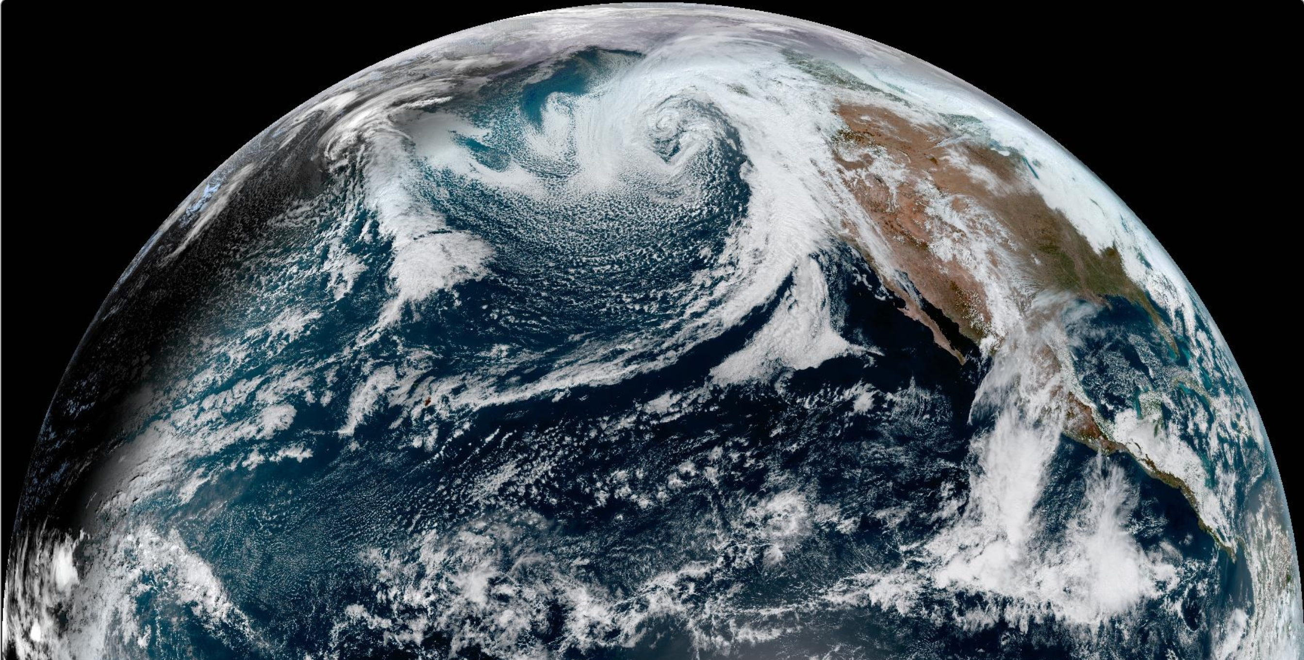
Quite the storm hitting the Sierras tonight through the weekend- but not much for us. Looks like the peaks around Tahoe could see over 10' of snow (feet- not inches) along with 100 mph+ winds. That storm will weaken as it hits San Diego later Friday into Saturday. Just look for 1/4" of rain by Saturday afternoon and winds around 25 mph from the SW. And here's what we have on tap for the next week:
  • Friday: Cloudy with increasing showers later. Temps 62/54.
  • Saturday: Rainy and windy. Temps 61/52.
  • Sunday: Clearing skies in the afternoon. Temps 60/49.
  • Monday through Wednesday: Clear and cool. Temps 60/48.
  • Thursday: Showers and breezy again?
  • Friday through Sunday: Sunny to start the weekend and showers late on Sunday?
BEST BET:

Not sure if there is a best bet with the weak windy storms moving through. But if I was a betting man...
  • Saturday with stormsurf. 
  • Early Monday with clean conditions and leftover short interval NW and smaller SW groundswell
NEWS OF THE WEEK:


From the 'Say It Ain't So' Department, scientists warn that a crucial ocean current could collapse this century, altering global weather. As if Texas wildfires in winter and tropical storms in southern California weren't enough. Here's what the LA Times had to say:

Scientists are sounding the alarm that a crucial component of the planet's climate system is in gradual decline and could one day reach a tipping point that would radically alter global weather patterns. The Atlantic Meridional Overturning Circulation, or AMOC, is a system of ocean currents that circulate water in the Atlantic Ocean like a conveyor belt, helping to redistribute heat and regulate global and regional climates. New research, however, warns that the AMOC is weakening under a warming climate, and could potentially suffer a dangerous and abrupt collapse with worldwide consequences. 


Considering the AMOC is the workhorse of the Atlantic, the consequences of such a collapse would result in "hugely chaotic changes in global weather patterns" that extend far beyond the Atlantic, said Daniel Swain, a climate scientist with UCLA who was not involved in the study. "It would plunge Europe into essentially a regionalized Ice Age, while leaving the rest of the world on its continued warming path," Swain said. "The Southern Hemisphere would roast, the Pacific storm track would go kind of nuts, and there would be these extreme shifts in weather patterns that are very different from what you would expect from a more incremental or linear warming path."

The odds of such a collapse are low — about 5% or 10% this century, according to some researchers — but the consequences are so great that it would be unwise to ignore the possibility, Swain said. "There's still a [90%] to 95% chance that won't happen, but would you be willing to bet the farm on a [90%] to 95% chance that something like this doesn't happen?" he said. "Would you get on a plane if there were a [90%] to 95% chance that it won't crash? I certainly wouldn't."

The AMOC moves water in the Atlantic Ocean from north to south and back again in a long cycle, but there are indications that it has been weakening over the last century, including a roughly 15% decrease since 1950. The system relies on a delicate balance of warm surface water and cold, salty water that sinks toward the sea floor, which together keep the current churning. But as the planet warms, melting glaciers and ice sheets — such as the Greenland ice sheet — are adding more freshwater to the system, which is diluting its salinity and disrupting traditional patterns. "It's a self-amplifying feedback loop mainly affecting salinity, and the fresher the North Atlantic Ocean becomes, the weaker the AMOC, until you reach a critical value," said René van Westen, the study's lead author. 

The study does not place a time frame on when such a collapse could occur, and Van Westen said such estimates can be controversial. But the paper was the first to demonstrate that the AMOC can reach a tipping point if enough freshwater is added to the system. "It is still heavily debated whether this is a possibility within the 21st century, but we cannot rule it out at the moment," he said. 

The Netherlands' researchers say that models indicate an AMOC collapse is possible, and that such an event would significantly alter the planet's climate. Its effects would be most acute in Europe, where temperatures could decrease up to 18 degrees on average, or even as much as 36 degrees in places such as Norway and Scandinavia. It could also trigger "seesawing" conditions between the Northern and Southern hemispheres. Other potential effects include rapidly rising sea levels, with more than 2 feet of sea-level rise possible along some coastal regions, including the Netherlands and the U.S. East Coast. New York City could be inundated by as much as 31 inches of sea-level rise, Van Westen said. 

The Amazon rainforest would see its dry and wet seasons flipped, potentially leading to its own tipping point. (A separate study published this month found that parts of that rainforest could collapse as soon as 2050.)  Effects on the Pacific Ocean and U.S. West Coast would probably be smaller due to their distance from the Atlantic, Van Westen said. However, his models show that an AMOC collapse could result in reduced precipitation and slight cooling in Los Angeles, which would compete with the larger climate change signal toward regional warming.

In fact, the potential future collapse of the AMOC is in some ways a scenario distinct from the climate change effects that are already occurring, said Swain, of UCLA. Currently, climate change is primarily amplifying familiar preexisting patterns and risks, such as worsening wildfires in California, or more extreme downpours and floods."But a collapse of the global overturning circulation really would be different, because it would result in rearrangements of the jet stream, of the storm track, of which places on Earth are really cold relative to other places," he said. 


The jet stream — the river of air that moves storms eastward across the globe — often helps steer atmospheric rivers into California. Such disruptions wouldn't just affect climate and temperature conditions, they would also tear at the fabric of civilization. Agriculture in Europe would probably come to halt, while coastal cities would see major issues from flooding. Building codes and infrastructure would potentially become obsolete as seasonality and precipitation patterns rapidly shift warm places into cool ones, and vice versa. 

"It would mean that all of the climate adaptation that we're working on now would not necessarily be the climate that we would be experiencing," Swain said. Other experts said some of the scenarios outlined in the study are on the extreme end of what's plausible. The model required exceptional amounts of freshwater flow into the Atlantic in order to trigger the tipping point — a quantity equal to about seven Greenland ice sheets — according to Josh Willis, an oceanographer with NASA's Jet Propulsion Laboratory in La Cañada Flintridge. 

"It's still possible that the overturning will shut down, and if it does, it'll have big implications," Willis said. "But it's not a meter of sea level right away and 15 degrees Celsius of cooling right away." Still, Willis said the system may be more sensitive than previously understood, and future models and simulations could add to the growing body of work. Other recent studies have also warned of a forthcoming AMOC collapse, and of a potential collapse of the Antarctic Ocean current. 

On the flipside: "It's an interesting study," he said of the latest paper, "and the AMOC could still yet prove to be shut-down-able. But this study is not necessarily conclusive about that. There's still a lot of questions open."  Lynne Talley, a distinguished professor at Scripps Institution of Oceanography at UC San Diego, said similarly that there is a "natural variability" to the AMOC that can include strengthening and weakening on a roughly decadal timescale, and cautioned against conflating recent changes with a long-term trend. 

However, she said the research into its potential collapse is compelling and worthy of consideration."First of all, it is possible.... I wouldn't shy away from saying that," she said. Salinity studies are particularly valuable, she added, because salinity helps govern the density of water in the AMOC. A similar mechanism may have made the AMOC crash at the end of the last glacial period around 14,000 years ago. Back then, a lot of freshwater got swept onto the North Atlantic from the melting of the North American ice sheet, "and that clearly slowed it down and it sort of stopped," Talley said. "I find it completely plausible that it would crash at some point, and the control is salt," she said. "But what year that happens? I don't know."

Such a collapse would probably be irreversible — at least over any sort of timescale relevant to a human life. But there are safeguards for preventing such a collapse from occurring: namely, reducing methane, carbon dioxide and other fossil fuel emissions that are warming the planet, melting ice and releasing more freshwater into the ocean. "That is really the solution to everything," Talley said. "I think we have to safeguard against a lot of things with climate change, and this is one of the big ones for the Northern Hemisphere."

BEST OF THE BLOG:


Mark your calendars! The North County Board Meeting is hob nobbing it this March at the beautiful Alila Marea Beach Resort in Leucadia. Looking to network with like minded individuals? Want to give back to your community? Want to learn more about this amazing hotel? Want to talk a little surf over a cold one? Done, done, done and DONE. Come join us at 5:30 PM sharp on Thursday, March 28th to get an exclusive behind the scenes look at this highly touted hotel. Don't be late though as you won't be able to find us once we get moving on this sprawling property! Sponsored by our good friend Andrew Becht from Acrisure, meet your fellow surfers to make some new connections, learn about the Alila brand, and finish it off with a bite and refreshments. Hit me up with any questions at northcountyboardmeeting.com and we'll see you at the Alila on March 28th!


PIC OF THE WEEK:


Everyone knows about Nazaré and it's potential for 100' surf. But just to the left of the famous point of land sits this stretch of beach. Not as large as it's big brother- but the shorebreak is nothing to sneeze at. Rideable? Yeah, right. 

Keep Surfing, 
Michael W. Glenn
Superhuman Strength
Slave To Fashion
World Famous Small Wave Rider

Thursday, February 22, 2024

THE Surf Report


Mellow Is Good.

SURF:


In our world of dog eat dog- mellow is a welcome sight for sore eyes. After countless storms, big surf, and wind, it's nice to take a breather around here (considering our sand and hillsides have washed away). For this weekend, we have a new swell- on the small side- but we we will have great weather. 


Surf starts out small on Friday (with light offshore winds) then picks up slightly by sunset for waist high+ sets and chest high in SD. That lasts into Saturday- then drops on Sunday to waist high. And here’s the sun, tides, and water temps for the upcoming weekend:
  • Sunrise and sunset:
    • 6:21 AM sunrise
    • 5:42 PM sunset 
  • Water temps are 60 incredibly enough (thanks El Nino!)
  • And not much in the way of tides this weekend:
    • about 3' at sunrise
    • over 5' mid-morning
    • about -0.5' late afternoon
    • and back to 1' at sunset
FORECAST:


Next week gets a little iffy as an average storm takes aim at So-Cal. Monday starts off small then starts to pick up in the afternoon as rain starts. Tuesday should have shoulder high NW wind/groundswell- but messy conditions. 


The 2nd half of the week is sunny and small- then maybe another storm and head high NW returns for the weekend. If anything changes between now and then, make sure to follow North County Surf on Twitter. 

WEATHER:


Great weather is in store this weekend before rain returns next week. Here's what we have on tap though for the next week:
  • Friday: Sunny and offshore in the AM. Temps 68/53.
  • Saturday: Sunny. Temps 67/53.
  • Sunday: Increasing low clouds. Temps 65/52.
  • Monday: Chance of rain and wind. Temps 61/52.
  • Tuesday: Showers. Temps 59/46.
  • Wednesday: Sunny and cool. Temps 62/47.
  • Thursday: Sunny. Temps 63/50.
  • Rain again next weekend?...
BEST BET:

Saturday if you like clean surf:
  • Saturday with the peak of the small W swell and nice conditions.
  • Tuesday with peaking storm surf (at least no one will be out)
  • And maybe next weekend if it's not stormy.

NEWS OF THE WEEK:


As you've seen over the past decade, the kelp forests off the California coast have slowly disappeared. But not entirely. Seems as though kelp is fairly resilient. But I'm getting ahead of myself. Why did the kelp go away in the first place? Here's research led by Monterey Bay Aquarium and the University of California, Santa Cruz...

New research reveals that denser, and more sheltered, kelp forests can withstand serious stressors amid warming ocean temperatures. Published in Proceedings of the Royal Society B, the study also offers the first comprehensive assessment of how declines in kelp abundance affected marine algae, invertebrates, and fishes living in Monterey Bay. The study comes after a multi-year marine heatwave -- the product of a 2014 'blob' of warm water prolonged by a 2015-2016 El Niño event -- bathed the North American west coast with sweltering sea temperatures.

It all started a decade ago when a triple-whammy of stressors -- the large marine heatwave, a sea star die-off, and a sea urchin outbreak -- led to pronounced declines in kelp abundance on California's central coast. Using a fourteen-year dataset, researchers discovered those events caused a 51% decline on average in kelp forest density in the years following the heatwave (2017-2020 vs. 2007-2013). As of 2020, the decline had increased to 72%. Some kelp forests, though, made it through these extreme events.

"We found that larger stands of giant kelp prevented shifts in sea urchin foraging behavior, and these persistent forests were better at withstanding multiple stressors," said Dr. Joshua Smith, the study's lead author and Ocean Conservation Research Scientist at Monterey Bay Aquarium.

"Something that surprised us was that persistent kelp forests were located in areas that are typically less productive. These persistent forests had a gradual reef slope and protection from wave exposure, which enabled them to become densely packed with kelp prior to the marine heatwave." While this study identified the importance of habitat features in driving forest persistence, predators can also help the kelp.

Another recent Monterey Bay Aquarium study reinforced the role that sea otters play in preventing kelp declines by eating up sea urchins. Where kelp patches were more exposed and less dense, the sudden rise of sea urchins in 2014 led many kelp forests to become 'barrens' -- areas scoured by hungry sea urchins along the rocky reef. Smith and co-authors examined changes in species composition across the mosaic of barrens and persistent forests to untangle how kelp loss impacts the broader ecosystem.

"While some kelp forests have endured, the structure of the ecological communities in the barren areas have yet to return to their pre-2013 state," Smith added. "Across the region, the number of species did not decline, but changes in their relative abundances led to an overall decline in species diversity, most notably for marine algae and kelp-associated invertebrates." With less kelp and other macroalgae around, the study noted a disproportionate increase in animals that eat plankton, such as barnacles, scallops, tube snails, and planktivorous fishes. The study sought to understand the effects and resulting consequences of the marine heatwave and is part of Monterey Bay Aquarium's larger effort to understand kelp recovery and restoration mechanisms. Globally, kelp has been declining for a half-century, and at an average rate of 1.8% a year.

With over half of the ocean surface experiencing extreme marine heat every year since 2014, warming ocean temperatures present a serious threat to cold-water species like kelp. As kelp forests and other marine ecosystems around the world face increasing threats associated with climate change, conservation of ecosystems, like kelp forests, and predators, like sea otters, can mitigate the impacts of extreme events.

"This study offers important insights to help inform strategies for protecting areas where kelp can persist on its own, and siting for kelp restoration efforts, here in California and around the world," said Dr. Pete Raimondi, a marine ecologist at UC Santa Cruz who was not a co-author on the study.

PIC OF THE WEEK:


Where is everybody?! Oh, that's right- those pesky orcas- the only known predators of Great Whites- are scaring everyone away. You can have it. 

Keep Surfing, 
Michael W. Glenn
Was An American Idol Before American Idol
Livin' The Dream
Caught In The Middle Of A Bidding War Between Gotcha And Op

Thursday, February 15, 2024

THE Surf Report


From Sizzle To Fizzle

SURF:


Let me be the first to say- this has been a pretty good El Nino winter. A couple monster swells in January, windows of great weather between storms, and lots of fun shoulder to head high groundswells every few weeks. Compared to last winter where we started off the same (a couple monster swells early) which was follow up by endless days of waist high surf for 9 months. All good things must come to an end though (details below in NEWS OF THE WEEK)- but before they do- let's go out with a bang. 


New fun WNW will fill in tonight for chest high waves tomorrow (shoulder high in SD) and that drops slightly on Saturday. Today, Hawaii is getting bombarded by a solid W swell that will arrive here Sunday morning for well overhead sets in N County SD and double overhead+ in SD. Weather should cooperate too. And here’s the sun, tides, and water temps for the upcoming weekend:
  • Sunrise and sunset:
    • 6:30 AM sunrise
    • 5:36 PM sunset 
  • Water temps are high 60's
  • And not much in the way of tides this weekend:
    • about 3' at sunrise
    • about 0' late morning
    • and up to 2.5' at sunset

FORECAST:

The big WNW on Sunday only drops slightly into Monday- and then the rain starts. Looks like we have a couple storms slamming into Central CA next week- so conditions will be suspect on Monday and a mess by Tuesday. 


On a side note- we have a small SW swell headed our way for Monday but it will most likely get lost in the big WNW. 


We then have a reinforcing WNW wind/groundswell on Tuesday for more double overhead surf- albeit junky. Once the storm exits mid-week, we'll have dirty water again and dropping surf. 


On it's heels though, models show another storm potentially moving in next weekend- which would bring more overhead surf- but windy conditions of course. If anything changes between now and then, make sure to follow North County Surf on Twitter. 

WEATHER:


As mentioned above, stormy weather is on its way- but we'll have nice weather in the interim. Here's what we have on tap though for the next week:
  • Friday: Mostly sunny skies. Temps 63/50.
  • Saturday/Sunday: Partly sunny. Temps 63/49.
  • Monday: Increasing showers. Temps 62/52.
  • Tuesday: Rain and wind. Temps 62/52.
  • Wednesday: Decreasing showers. Temps 60/50.
  • Thursday: Mostly sunny. Temps 62/52.
  • Rain again next weekend?...
BEST BET:

Might need to turn on the Emergency Broadcasting System on Sunday:
  • Friday with new fun WNW.
  • Sunday with bombing surf (not as big as January's behemoths, but I'll take it).
  • Maybe next Friday IF... the rain can hold off until Saturday.

NEWS OF THE WEEK:


Alas, all good things must come to an end. After 3 La Nina crummy winters for surf in 2020/21, 2021/22, and 2022/23, models predict our current 2023/24 El Nino will transition fairly quickly to La Nina THIS spring. Who's ready for cold water this summer, MIA hurricanes, and waist high windswell next winter? Not me. Here's what the National Oceanic and Atmospheric Administration had to say about the recent cooling waters in the equatorial Pacific...

On a brisk early February morning, all of us El Niño-Southern Oscillation (ENSO) forecasters emerged from our burrows and saw our shadows. That can mean only one thing: conditions are favorable for the development of La Niña within the next six months. Yes, the February ENSO Outlook officially announces that we are in a La Niña Watch, even while, at the current moment, the Pacific Ocean remains in an El Niño (this is simultaneous to the ongoing El Niño Advisory—here is an explainer to help sort it out). The outlook gives a 79% chance that El Niño will transition to ENSO-Neutral by the April–June period, and then a 55% chance the Pacific transitions into La Niña in June–August. Confused? I’ll explain it all without the help of any prognosticating rodents (take THAT, Punxsutawney Phil).

El Niño’s current status

Let’s start with the here and now. At the current moment, El Niño remains across the equatorial Pacific Ocean. In January, sea surface temperatures remained above average across most of the Pacific, though temperatures fell a bit across the eastern and central Pacific. Monthly values in the Niño-3.4 region (the key tropical Pacific monitoring region for ENSO and the basis for the Oceanic Niño Index (see below) dropped from just over 2°C above average in December 2023 to 1.87°C above average in January 2024. Overall, the most recent Oceanic Niño Index (ONI) value—how NOAA classifies the strength of events—for November–January places this event’s peak strength at ~2°C, or the fifth highest on records back to 1950.

Atmospherically, El Niño weakened a bit as well over the last month. Remember, El Niño is an ocean-atmospheric phenomenon. During El Niño, the atmosphere over the tropics—the Walker Circulation—gets all jumbled up. The result in the Pacific is weakened trade winds, an increase in thunderstorm activity near the Dateline, and a reduction in thunderstorms across the Western Pacific (also, usually, across the Amazon). However, in January, the trade winds were closer to average across the equatorial Pacific, and while thunderstorm activity remained a bit elevated near the Dateline, it was instead closer to average across Indonesia in the western Pacific.

Put together, it looks clear that this El Niño event is past its peak. However, it’s important to remember that El Niño’s impacts on global temperature and precipitation can linger through April.


Is that all?

While everything I said above is all fine for the surface, the BIG story is happening underneath the sea surface in the Pacific. Averaged across the entire equatorial Pacific Ocean, ocean temperatures in the upper 300 meters returned to near-average for the first time in almost a year. And it’s clear that cooler-than-average ocean waters are widespread at depth and  expanding eastward, even while above-average temperatures persist closer to the surface in the central/eastern Pacific.

Where is this all going?

That’s the million-dollar question. The seasonal prediction models that forecasters look to for guidance are pretty confident in a transition from El Niño to ENSO-neutral sometime during the northern hemisphere spring 2024. Following that, there is a general consensus among the models that La Niña will follow during the summer. Now when it comes to transitions, there is always a bit of uncertainty on the exact timing, as an El Niño can end in a hurry. After all, the current outlook has only a two-season difference between the end of El Niño (79% chance in April-June), and the start of La Niña (55% chance in June-August). And some of the influencers of that transition can be atmospheric patterns that are not forecastable this early on, like the Madden-Julian Oscillation or random weather events.

How common are transitions from El Niño to La Niña?

Going back to 1950, over half of the El Niño events were followed shortly thereafter by a transition to La Niña (after a brief period of time in ENSO-Neutral). So, it would not be at all uncommon to see this sort of potential outcome this year.

Breaking that down even more by looking at similar strong El Niños, five of the eight events since 1950 were followed by a La Niña. And that transition happened rapidly. Two years (1973 and 1998) had only one 3-month period of ENSO-Neutral conditions before switching to La Niña. Two years (1983, 2010) had two 3-month periods of ENSO-Neutral in between. And 2015 had three 3-month periods.

Suffice to say, the historical record suggests that if the equatorial Pacific moves from a strong El Niño into a La Niña, it doesn’t seem to waste its time.

PIC OF THE WEEK:


I'm pretty sure if Cha-Ka from Land of the Lost was a surfer, he'd be a local at this spot. 

Keep Surfing, 
Michael W. Glenn
C-suite Level
Performing At The Sphere Next Month
Let's Just Cut To The Chase And Award Me The Eddie

Thursday, February 8, 2024

THE Surf Report


Eye Of The Storm

SURF:

Soggy yet? If you live in L.A. you are (more on that below). 


Dirty water and storm surf this past week made it a no-go in the surf department. For this weekend, we've got cleaner? conditions and dropping NW for chest high sets. 


On Saturday/Sunday, the NW backs off to the waist high+ range but we've got some early season SW for waist high sets too (better towards the OC). The small combo swell should keep us in rideable waves this weekend but much smaller than what we've seen recently. And here’s the sun, tides, and water temps for the upcoming weekend:
  • Sunrise and sunset:
    • 6:36 AM sunrise (maybe 6 am paddle out?)
    • 5:30 PM sunset (maybe 6 pm paddle in?)
  • Water temps are 58 due to all the NW wind yesterday
  • And tides are fluctuating wildly this weekend:
    • about 4' at sunrise
    • 6.5' mid-morning
    • down to -1.5' late afternoon
    • up to 1' at sunset
FORECAST:

High pressure is in control (finally) so the storm door is shut for early next week. Look for nice conditions but only waist high NW if you're lucky. 


Storms start taking aim at us later in the week so we should see an uptick in WNW towards Friday for shoulder high surf. By late Sunday, if the forecast charts are right, we'll see head high+ WNW again- but deteriorating conditions. And for the work week of February 19th, it could be big again- but rain and wind. If anything changes between now and then, make sure to follow North County Surf on Twitter

WEATHER:


Looking forward to seeing some of that good ol' sunshine this weekend. But first- a couple more showers tomorrow. High pressure then sets up shop for the foreseeable future and we'll have nice, sunny, cool conditions Saturday 'til Friday. Then... models predict more heavy rain for the week of February 18th. Here's what we have on tap though for the next week:
  • Friday: Some stray showers. Temps 57/47
  • Saturday: Sunny and cool. Temps 60/42
  • Sunday to Friday. Sunny. Temps 62/46. 
  • And will rain return next weekend and really hit us hard by Monday the 19th?...
BEST BET:

Once the water cleans up, here's some options:
  • Saturday with small combo swell and sunny skies.
  • Next Friday with new fun WNW and maybe our last day of sun?
NEWS OF THE WEEK:


Multiple storms this week did a doozy in California. Just in Los Angeles alone, the devastating storm caused more than 500 mudslides- and even more throughout southern California- and severely damaged more than 45 homes or buildings, flooded countless roads and forced dozens of evacuations. Statewide, officials have confirmed, nine people died in the storm. Over the last five days, Los Angeles firefighters helped 50 motorists stranded in water and swift water teams rescued five people, including a man who jumped into the roaring Pacoima Wash to save his dog (which also survived), according to the Los Angeles Fire Department. The National Weather Service also reported there was a probable tornado in the Pismo and Grover Beach area Wednesday afternoon, where wind gusts from the storm pushed 60 mph, downing trees and power lines. The Oxnard office of the National Weather Service had not yet confirmed the tornado, but was planning to assess damage to "determine if the damage in this area was due to a tornado, or severe straight-line winds."

If that's not enough, here's some astronomical rain/wind data from the storms this past week:

Rain:
  • Lytle Creek 15.45" (just east of the Interstate 15/215 merge)
  • Topanga 14.2" (yes, you read that right)
  • Bel Air 13.65"
  • Woodland Hills 12.88"
  • Mt. Baldy (4300') 10.21"
  • Downtown LA 9.03"
  • San O' 8.13"
  • Coto de Caza 7.4"
  • San Onofre 7.28"
  • San Juan Capistrano 5.28"
  • Laguna Beach 4.8"
  • Fallbrook 5.22"
  • Oceanside 4.17"
  • Encinitas 2.88"
  • San Diego Airport 2.68"
  • Palm Springs- only 0.88"!
  • And as a bonus, Mountain High Ski Resort had almost 4' of snow and Snow Valley a whopping 5'!
Winds:
  • Magic Mountain 83 mph
  • Pt. Conception 74 mph
  • Catalina Airport 60 mph
  • Paso Robles 59 mph
  • Topanga 52 mph
  • Oceanside 44 mph
  • San Diego 35 mph
As mentioned earlier, we're not out of the woods yet as on average, our rainiest months are December through March- so we're just over the halfway point with more storms forecasted the week of February 19th. With all that being said, where do we stand before and after last week's storms?
  • Los Angeles: seasonal total of 5.6" on 1/25. Today it's at 13.66" (normal is 7.06"), so we're 193% of normal.
  • Newport Beach: seasonal total of 3.65" on 1/25. Today it's at 8.82" (normal is 6.54"), so we're at 135% of normal.
  • Oceanside: seasonal total of 5.58" on 1/25. Today it's at 11.25" (normal is 6.31") so we're at 178% of normal. 
  • San Diego: seasonal total 5.06" on 1/25. Today it's at 8.36" (normal is 5.40") so we're at 155% of normal. 
And with the potential of storms coming soon, any guess at what we'll be at by the end of February?...

PIC OF THE WEEK:


When these storms finally go away (like in July), I'm hoping to see some of this. 

Keep Surfing, 
Michael W. Glenn
Beneficial
Making My Return As Left Shark On Sunday
2024 Super Barrelled MVP

Thursday, February 1, 2024

THE Surf Report


El Ninoesque

SURF:

All the flavor of El Nino but only half the calories! (Or, all the rain but 1/2 the giant surf). 


Lots of amazing surf this past week has now turned to storm surf today from an El Nino fueled low pressure system. No big El Nino surf to speak of but plenty of El Nino rain to speak of. A vigorous cold front has moved through today with plenty of rain, wind, and jumbled surf. 


For Friday, the storm exits in its wake is well overhead W swell and dirty water. Saturday stays up- and is cleaner- then Sunday drops like a ROCK and is small by late afternoon. And here’s the sun, tides, and water temps for the upcoming weekend:
  • Sunrise and sunset:
    • 6:42 AM sunrise 
    • 5:24 PM sunset 
  • Water temps are 58-60
  • And tides are mellow this weekend:
    • about 3.5' at sunrise
    • around 1' mid-day
    • and back to 3' at sunset
FORECAST:

On Monday, El Nino kicks in again with rain and building WSW windswell- and most likely junky conditions.  High pressure should set up later in the week and we'll be back sunny skies and cleaner conditions. 


That same high pressure will block our storm production so look for smaller NW towards Friday in the chest high range- and better in SD. If anything changes between now and then, make sure to follow North County Surf on Twitter

WEATHER:


Good storm today if I don't say so myself. Most areas received 1.5" and we're just left with showers tonight. Look for mostly sunny skies on Friday/Saturday and MOST of Sunday. THEN... another potentially larger system moves in early next week. Models have been all over the place the past few days but have been narrowing their focus today and we could see significant rain from Monday to Wednesday. Not to sound the alarm here, but 3"+ sounds likely and the lower slopes of the So-Cal mountains could see up to a foot... of rain. Here's what we have on tap for at least the next 7 days:
  • Friday: Partly sunny skies and breezy. Temps 60/50.
  • Saturday: Sunny and afternoon W winds. Temps 60/45.
  • Sunday: Chance of sun in the AM, then a chance of rain by the afternoon. Temps 62/49.
  • Monday. Heavy rain. Temps 60/50.
  • Tuesday: See above.
  • Wednesday: Showers. Temps 60/50.
  • Thursday and beyond: SHOULD start cleaning up? Sunny for the weekend. 
  • And in case you're interested, models show the sun should stick around mid-month, then we may be back to rain around the 3rd week of February. 
BEST BET:

Clean groundswell and great conditions look to be in our rearview mirror for the time being. We may though have a couple opportunities for surf and clean conditions:
  • Saturday with leftover solid surf, the sun returns, but we could see breezy WNW winds in the afternoon.
  • Early Sunday with rapidly dropping swell but clean conditions.
  • Next Friday with new smaller NW and clean conditions finally.
NEWS OF THE WEEK:


With an exiting storm and another STORM arriving next week, what are we anticipating weather-wise for February in California (and the rest of the US)? The Climate Prediction Center came out with their monthly forecast this week and here is what they had to say:

After experiencing the warmest December in the historical record, winter finally appeared across the United States during January. Mid-January saw an Arctic outbreak that plunged temperatures well-below freezing across most of the country and brought the first measurable snowfall in the big cities of the mid-Atlantic and the Northeast in almost two years. Well above normal temperatures did return to the country at the end of the month, so what can we expect during the last month of meteorological winter. Will the cold and snow return for an encore presentation or will the warmth seen at the end of January continue? Let’s see what NOAA’s Climate Prediction Center (CPC) predicts for the last month of winter.

On January 31, CPC released its updated monthly climate outlooks for temperature, precipitation, and drought across the United States for February 2024. The temperature outlook favors well above normal temperatures across much of the northern half of the nation, and near-average temperatures in parts of the Southwest and Southeast. The precipitation outlook favors well above average precipitation (rain and/or snow) across large parts of the southern, central, and southeastern parts of the country, with well below average precipitation favored in the Pacific Northwest and around the Great Lakes, Ohio Valley, and in the Northeast.

El Niño remained strong during January across the tropical Pacific, and while it’s expected to begin weakening, impacts to the global climate will continue for at least the next few months, so it was again considered as the dominant teleconnection for the outlooks during February. The Madden-Julian Oscillation (MJO)—a conjoined area of heavy rains and clear, calm skies that travel the tropics together as a couplet—was also active, with its heavy rains located over the western Pacific at the end of January. However, computer models have a large degree of uncertainty on the future evolution of the MJO at this time, so forecasters considered the MJO’s potential influence only during the first two weeks of the month.

Temperature Outlook


The February temperature outlook has enhanced odds for well above average temperatures across the northern half of the country from the Pacific Northwest through the central and northern Great Plains into parts of the Northeast. In contrast, near-average temperatures are favored in parts of the southwestern and southeastern U.S., with no parts of the country predicted to have a colder-than-average February. The highest odds for a warmer-than-average February reside in the Northern Plains, where probabilities exceed 70%, while odds for above-average temperatures in the Northeast are less than 50%.

The first week of February will begin with temperatures 20°-40° F above average across much of the northern Plains, and with temperatures strongly favored to remain above average in the CPC Week-2 Outlook, confidence is quite high that the monthly average will end up in the upper tercile. (Tercile refers to a third of the climate record.) Probabilities tilting toward above average extend both westward into the Pacific Northwest and eastward into the Northeast, but with lower probabilities. 

After a warm start to the month in the West, Week-2 is favored to be below-average, but the Week 3-4 outlooks rebound back to favoring above-average temperatures. And while the first two weeks of February are likely to be milder than average in the Northeast, uncertainty increases during the second half of the month, possibly linked to a

Near-average temperatures are favored for parts of the Southwest, where temperatures are favored to be near- to below average early in the month and near- to above average later in the month. Near-normal temperatures are also favored for coastal areas of the Southeast, where decadal temperature trends are positive and El Niño favors below-average temperatures.

Precipitation Outlook


Well above average precipitation is favored across much of the southern part of the nation, with probabilities for a wet February highest in southern and central California and Nevada (exceeding 60%). This region is predicted to have substantial precipitation during the first week of the month, with amounts potentially exceeding the above-normal threshold for the entire month.

Farther east, above-average precipitation is favored northeastward into the Central Plains. Odds for a much wetter than average February exceed 50% for parts of this region, as normal February precipitation is relatively low and predicted amounts early in the month may also exceed the above-normal limit. Lower probabilities for above-average precipitation are found in the Southern Plains, and along the Gulf and South Atlantic Coasts, consistent with Week-2 and Week 3-4 Outlooks as well as typical impacts associated with El Niño.

Well below average precipitation is slightly favored in the Pacific Northwest, and in much of the Midwest and Northeast. Probabilities are all less than 50%, although CPC’s 6-10-day outlook tilts toward below average in the Northeast and the Week 3-4 Outlooks favor below-average precipitation in both of those regions. These outlooks are also consistent with typical impacts from El Niño during the late winter in the Pacific Northwest and in the Midwest.


During January, the amount of drought across the United States decreased significantly, with the percent of the contiguous U.S. in drought decreasing from around 32.5% near the end of December to about 23.5% by the end of January. Additionally, the percent of the country in the two most intense categories (D3-D4, representing extreme and exceptional drought) also decreased, from about 6.5% to under 2.5%. This is the lowest amount of drought across the country since June 2023.

Drought improvement occurred across most of the country, with the exception of in the Northern Rockies and parts of the Southwest, where degradation was generally on the order of 1-2 classes. The most significant drought improvement occurred across parts of the Southeast and mid-Atlantic, where improvements of up to 3-4 classes were recorded. The improvement resulted in drought removal in the mid-Atlantic and improvements in the Tennessee Valley generally from extreme drought (D3) to either moderate drought (D1) or just abnormally dry (D0). Drought improvement in the Pacific Northwest resulted in some drought removal, while in the Central Plains, drought mainly improved 1-2 classes, from extreme (D3) to severe (D2) or even moderate (D1) levels.

Drought Outlook


The drought outlook for February favors improvement and/or removal in parts of the Southwest, southern and central Plains, and in the Southeast. Drought removal is predicted in regions currently in moderate drought, with improvement, but not removal, forecast for areas in more significant drought. Drought is expected to persist in other regions currently in drought, although drought development is not predicted for any new parts of the nation during the month.

Improvement in Arizona and western parts New Mexico and Colorado is consistent with forecasts for above-normal precipitation. However, despite the tilt toward above-normal precipitation, drought persistence is predicted for the remainder of New Mexico, as February is a rather dry time of the year. A typically active southern storm track associated with the background El Niño state favors above-average precipitation and drought improvement and removal for parts of central and eastern Texas, and in the Lower Mississippi and Tennessee Valleys. Other regions across the nation where drought is likely to persist are either favored to experience a drier-than-normal February or are locations that are typically dry during the late winter.

PIC OF THE WEEK:


It's time to play... NAME. THAT. SPOT!:

Is it...
  • Baja
  • Portugal
  • California
  • Morocco
Wrong answers only. 

Keep Surfing, 
Michael W. Glenn
The Man
Letting Taylor Borrow My G6 From Tokyo To Vegas
I Never Surf In The Rain Because I Don't Like To Get Wet