Friday, September 27, 2019

THE Surf Report


Thar she blows!

SURF:


Fun surf earlier in the week deteriorated as weak low pressure moved in and blew it to bits. I thought fall was all about Santa Anas?! 


That's going to be the case again this weekend as new SW/NW builds and another low pressure system moves in late Saturday. Look for chest high waves on Saturday from the SW, then head high surf on Sunday as NW moves in, but bumpy and a chance of showers. At least the water is still 70!

And here's additional info to help you with your next surf session (if you dare brave the wind):

Tides this weekend are:
  • 3' at sunrise 
  • 5.5' mid-morning
  • 0' mid-afternoon
  • and back to 3' at sunset
And here's what the sun is doing this weekend behind all those clouds:
  • 6:42 sunrise
  • 6:39 sunset
FORECAST:
Monday/Tuesday will have leftover SW swell and a continuation of NW windswell. Most areas will have shoulder high sets on Monday with Tuesday being in the chest high+ range- and questionable conditions. The 2nd half of the week looks smaller but cleaner with just background waist high SW/NW. 


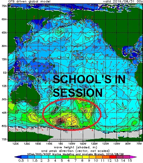
Charts show some activity off Antarctica this weekend which may give us chest high SW again towards the 5th and MAYBE some small hurricane activity if soon to be Mario can get his act together. Make sure to check out Twitter/North County Surf as details emerge.

WEATHER:


As I mentioned last week, summer is OFFICIALLY over and fall is OFFICIALLY here. In a big way. We've got an early season low pressure system moving through this weekend that will bring snow to the Sierras/Rockies and the tail end may give us showers on Saturday. Batten down the hatches! We'll at least get some breezy conditions out of it and cool temps. Look for 1/10" at the coast, 1/4" inland, and up to 1" in the mountains. Sunday/Monday look to be cool/breezy and temps should rebound slightly to the high 60's by mid-week with sunnier skies. 

BEST BET:
Tough call- plenty of surf Sunday but breezy as the low pressure exits the region. Or small and clean later next week. Take your pick! 

NEWS OF THE WEEK:


Scorching temperatures around the world last month tied August 2019 as the second-hottest August on record and capped off the hottest Northern Hemisphere summer (June through August), tied with 2016. The heat also impacted Arctic sea ice coverage, shrinking it to the second smallest for the month on record.

Here are highlights from NOAA’s latest monthly global climate report:

August 2019:
The average global temperature in August was 1.66 degrees F above the 20th-century average of 60.1 degrees, tying it with 2015 and 2017 as the second-hottest August in the 140-year record, according to scientists at NOAA’s National Centers for Environmental Information. The hottest August on record was August 2016, and the five hottest Augusts on record have all occurred since 2014.

The global sea surface temperature last month was 1.51°F above the 20th century monthly average of 61.4°F, making it the highest global ocean temperature for August on record. (Wonder why we have 70 degree water heading into October)?

Meteorological summer (Northern Hemisphere) | Year to date:
June through August 2019, was the Northern Hemisphere’s hottest meteorological summer on record, tied with 2016.  The period of June through August, which also marks the Southern Hemisphere’s winter, was the planet’s second hottest in the 140-year record at 1.67 degrees F above the 20th-century average, behind June-August of 2016. The last five June-August periods are the five hottest on record.

The period from January through August produced a global temperature that was 1.69 degrees F above the 20th-century average of 57.3 degrees, making it the third hottest January-August period on record after 2016 and 2017.

More notable stats and facts:
Sea ice retreats:  The August Arctic sea ice coverage was 30.1 percent below average, right behind August 2012’s record-lowest extent.  Antarctic sea ice extent was the fifth smallest August extent on record.

Regional record heat: Europe, Africa and the Hawaiian region had August temperatures that ranked among their three hottest Augusts on record.

Scorching season for some: Africa had its warmest June–August since records began. South America and Europe had a June–August temperature that ranked among the three-warmest such periods on record.

At least the water is still 70! (I think I mentioned that already).

PIC OF THE WEEK:


There's a reason I call California home. Until the other 49 states build a wave pool like Rincon and open a decent Mexican food joint, I'm staying put- regardless of the $4 a gallon gas prices. 

Keep Surfing, 

Michael W. Glenn
Stately
Snubbed For J-Lo At the Super Bowl Halftime Show
Started A Website With Videos of My Friends Getting Barreled Called YouTubed  

Thursday, September 19, 2019

THE Surf Report- Early Edition


Welcome fall! (Officially)

SURF:


If you haven't noticed, fall is already here. Beaches are empty, we've had some fun NW the past few days (with leftover SSW), air temps are cool and crisp, and the cold fronts up north are slowly creeping our way. The only remnant of summer is our 70 degree water temps. Thank you Global Warming! For this weekend we have a mixed bag of small but rideable surf. 


First up is a SW swell generated last week off Antarctica. Along with building NW windswell, we'll see waist to chest high surf on Friday. The NW drops on Saturday and we're left with waist high+ SW swell. 


On Sunday, we may start to see signs of a small S swell from weak hurricanes Mario and Lorena, along with tiny NW windswell. That will put us back into waist high+ surf again. Weather should be nice though, so we have that going for us.  

And here's additional info to help you with your next surf session:


Tides this weekend are:
  • 3' at sunrise 
  • 5' mid-afternoon
  • 3' at sunset
And here's the sunrise and sunset- exactly 12 hours of sunlight. That wouldn't have anything to do with fall, would it? (You'll have to read the NEWS below to find out):
  • 6:40 AM sunrise  
  • 6:40 PM sunset  
FORECAST:
If the models hold correctly, we'll get a slightly bigger boost each day from Mario and Lorena- along with better NW windswell- peaking on Tuesday. Look for chest high+ surf IF... Lorena and Mario keep heading our way. They could also slam into Cabo or die before they hit our swell window, so there's a lot that could go wrong between now and then, so think positive people!


Further out, we have another small storm in the southern hemisphere and a storm off the Aleutians which could combine to give us chest to shoulder high surf around the 27th. Nothing big on the horizon but fun surf at least. Make sure to check out Twitter/North County Surf. 

WEATHER:


As you've probably noticed, we've had some weak cold fronts move through the past week and along with the Chargers underachieving, fall is right on schedule. Our cold front moves through tonight and we've got a slight warm up this weekend- along with weak offshore winds. June Gloom seems like a distant memory at this point; might as well just leapfrog to winter. Look for temps in the mid-70's at the beaches tomorrow and 80 by Sunday. Early next week, models hint at the remnants of Lorena and Mario making their way into CA/AZ and there is a SLIGHT chance of showers along the coast. But I'm placing my bets on the deserts instead. 

BEST BET:
Tomorrow with small fun combo swell or next Tuesday with small fun combo swell OR next Friday with fun slightly bigger combo swell. 

NEWS OF THE WEEK:


Stop me if you've heard this before, but fall is here! But just what does fall mean? Or summer for that matter. Or winter. Or... spring of course. We know the seasons change and are fairly distinct between summer, fall, winter, and spring, but why is that? Here's National Geographic to explain: 

A season is a period of the year that is distinguished by special climate conditions. The four seasons—spring, summer, fall, and winter—follow one another regularly. Each has its own light, temperature, and weather patterns that repeat yearly.

In the Northern Hemisphere, winter generally begins on December 21 or 22. This is the winter solstice, the day of the year with the shortest period of daylight. Summer begins on June 20 or 21, the summer solstice, which has the most daylight of any day in the year. Spring and fall, or autumn, begin on equinoxes, days that have equal amounts of daylight and darkness. The vernal, or spring, equinox falls on March 20 or 21, and the autumnal equinox is on September 22 or 23.


The seasons in the Northern Hemisphere are the opposite of those in the Southern Hemisphere. This means that in Argentina and Australia, winter begins in June. The winter solstice in the Southern Hemisphere is June 20 or 21, while the summer solstice, the longest day of the year, is December 21 or 22.

Seasons occur because Earth is tilted on its axis relative to the orbital plane, the invisible, flat disc where most objects in the solar system orbit the sun. Earth’s axis is an invisible line that runs through its center, from pole to pole. Earth rotates around its axis.

In June, when the Northern Hemisphere is tilted toward the sun, the sun’s rays hit it for a greater part of the day than in winter. This means it gets more hours of daylight. In December, when the Northern Hemisphere is tilted away from the sun, with fewer hours of daylight.

Seasons have an enormous influence on vegetation and plant growth. Winter typically has cold weather, little daylight, and limited plant growth. In spring, plants sprout, tree leaves unfurl, and flowers blossom. Summer is the warmest time of the year and has the most daylight, so plants grow quickly. In autumn, temperatures drop, and many trees lose their leaves.


The four-season year is typical only in the mid-latitudes. The mid-latitudes are places that are neither near the poles nor near the Equator. The farther north you go, the bigger the differences in the seasons. Helsinki, Finland, sees 18.5 hours of daylight in the middle of June. In mid-December, however, it is light for less than 6 hours. Athens, Greece, in southern Europe, has a smaller variation. It has 14.5 hours of daylight in June and 9.5 hours in December.

Places near the Equator experience little seasonal variation. They have about the same amount of daylight and darkness throughout the year. These places remain warm year-round. Near the Equator, regions typically have alternating rainy and dry seasons.

Polar regions experience seasonal variation, although they are generally colder than other places on Earth. Near the poles, the amount of daylight changes dramatically between summer and winter. In Barrow, Alaska, the northernmost city in the U.S., it stays light all day long between mid-May and early August. The city is in total darkness between mid-November and January.

PIC OF THE WEEK:


Came across this image of Rincon before the houses were built on the point, circa 1920, shot from above with a drone. Ok- you caught me lying- yes, there were homes already on the point in 1920.

Keep Surfing, 

Michael W. Glenn
Riveting
Going to Storm Area 52 Instead And Check Out Bigfoot
Skilled At Shredding Waves AND Cheese

Thursday, September 12, 2019

THE Surf Report- Early Edition


Welcome fall!

SURF:


Good surf this past week- except for an early season fall-like low pressure system and it's associated S winds. But things cleaned up today as high pressure built and the SW surf slowly subsided. For the weekend, the lack of real storms in the Pacific last week means small SW/NW for us the next few days.


We had a little disturbance in the Southern Hemisphere a few days ago though which will give us a little boost by Sunday. Look for chest high sets in far N county SD and the OC. We also have a small boost of NW wind/groundswell on Sunday as yet another low pressure system makes it way through the west coast. All in all some small surf on Friday/Saturday with nice conditions and slightly bigger on Sunday with more wind and cooler conditions. And our water temps are still in the low 70's!

And here's additional info to help you with your next surf session:


Tides this weekend are:
  • 2' at sunrise 
  • 5' late morning
  • 1' late afternoon
  •  3' at sunset
And here's the sunrise and sunset:
  • 6:30 AM sunrise  
  • 7:00 PM sunset  
FORECAST:
Still not much happening in the southern hemisphere but models show the north Pacific coming to life and maybe some hurricane activity off Baja/Mexico next week.


First up is small waist high+ NW windswell on Monday, followed by a chance of small chest high hurricane S on Tuesday/Wednesday (better in the OC) from Tropical Storm Kiko. Kiko unfortunately may only hit minimal hurricane status over the weekend. Behind that is another shot of waist to chest high NW windswell and then the models get interesting.


Looks like a fun storm off Antarctica this weekend which may give us shoulder high sets from the SW around the 20th.


Then a 2nd hurricane is on the charts which could be solid (take it with a grain of salt since it hasn't formed yet) but we could see shoulder high sets in north SD county (and bigger in the OC) around the 23rd along with more NW. If anything changes between now and then though (I'm talking to you hurricanes), make sure to check out Twitter/North County Surf. 

WEATHER:


Southern California weather is some of the most diverse in the world. In the winter, we'll have a couple days of windy, cold rain, and then on it's heels- a Santa Ana condition with temps in the 90's, plenty of sun, and low humidities. This past week had a little of everything too: awesome beach weather, then thunderstorms at the coast, then a couple early fall low pressure systems (I know it's only a week away from fall- but still- I'm trying to hold onto summer) rolled through with windy, cool conditions (and a dusting of snow in Utah). So are we back on track with great September weather this weekend? Not exactly. High pressure set up shop today for sunny skies and warm temps and that will last into Saturday. Then yet another early low pressure system rolls through on Sunday/Monday for more wind, cool conditions, and lingering clouds. High pressure should set up behind that and late next week we're back to sunny skies and warm temps!    

BEST BET:
Next Tuesday/Wednesday with MAYBE small but fun hurricane swell and NW windswell. OR... better SW swell around the 20th and hurricane S on the 23rd?

NEWS OF THE WEEK:


This is the time of the year when we transition from summer to fall. Call it 'locals summer' or 'Indian summer' or even the dreaded 'fire weather' season. Whatever you call it, be prepared for 'Santa Ana winds'. Over the years I've spoken about the pros and cons of the winds (Pros- it cleans up our surf. Cons- that whole wildfire thing) and I thought it may be a good time to go into detail again. Here's what our friends at Accuweather had to say:

Santa Ana winds are high-speed and dangerous winds that periodically kick up and blow from the mountains to the coast in Southern California.

These northeasterly winds blow from the coast ranges to the beaches as areas of strong high pressure build across the interior West. The phenomenon typically peaks in October but can occur anytime from late to early spring.


The wind speed can be magnified as air tries to squeeze over mountain passes and rush downhill through the canyons that are aligned in a northeast to southwest direction. As the air descends in elevation, it becomes compressed and heats up and dries out even more.

Moderate Santa Ana winds can often break tree limbs, send unsecured debris flying into windows, raise clouds of dust and cause wildfires to ignite and spread rapidly.

In addition to a heightened risk of wildfires, whole trees and high-profile vehicles can be knocked over, and sporadic power outages are likely in more extreme cases.

When winds aloft become aligned from the same direction as that of the winds near the surface, the strongest gusts occur. Sometimes wind gusts can reach the force of a hurricane (74 mph or greater). Gusts during this particular setup can lead to extensive property damage and widespread power outages.


Most Santa Ana events peak for a 12- to 24-hour period, then the winds ease," according to AccuWeather Senior Meteorologist Ken Clark. "However, on rare occasions, strong winds can persist for a few days.”
While a wildfire can break out in absence of a Santa Ana, it is during these long-lasting events, that multiple and extensive wildfires can result. The most notorious Santa Ana winds can bring exceptionally hot weather. Under these circumstances, the risk of wildfire ignition and spread is the greatest. Temperatures can surge past 100 degrees Fahrenheit near the coast, even during the autumn, winter and spring months.

When the air gets this hot, it also become extremely dry. When brush is also very dry, as is often the case, the wildfire potential becomes extreme and people must be extremely careful with any open flames, including from burning cigarettes and outdoor power equipment that may lead to sparks.

Sometimes cool or cold air is associated with a Santa Ana. While such an event results in a lower fire risk when compared to a warm Santa Ana, there is still a significant risk of wildfire ignition. This is because the air is often still very dry and strong wind gusts can quickly cause any small fire that breaks out to rapidly spread.
In the wake of a chilly Santa Ana during the late fall, winter and early spring, a frost or freeze can occur in the normally cold spots, where the sky remains clear and breezes subside.

PIC OF THE WEEK:


Winter's coming. Are you ready? Put that apple fritter down from Leucadia Donuts and get to the gym asap!

Keep Surfing, 

Michael W. Glenn
Mistak Free
Was Fired From Hostess For Stealing
Stopped Doing Contests Because I Ran Out Of Space For My Trophies

Friday, September 6, 2019

THE Surf Report


Welcome summer!

SURF:


Not much surf to start the week but things started to look better yesterday as SW groundswell, S swell from Hurricane Juliette, and NW groundswell filled in. Along with water temps in the 75-79 degree range, warm humid weather, sunny skies, and tropical clouds overhead, summer has finally arrived- 2 weeks before fall! Better late than never. Look for chest high surf today with shoulder high sets in the OC. Julliette and the SW groundswell hold on Saturday (along with a continuation of the NW) and we'll have fun surf through Sunday morning. Long story short- skip your kid's soccer game, forget about mowing the lawn, and GET OUT THERE!

And here's more numbers to crunch:


Tides this weekend are pretty mellow:
  • 4' at sunrise 
  • 2.5' at lunch
  • 5.5' at dinner
And here's the sunrise and sunset. If the low clouds aren't too thick, you can most likely paddle out at 6 AM and paddle in at 7:30 PM.
  • 6:27 AM sunrise  
  • 7:06 PM sunset  
FORECAST:


On the heels of Julliette and the SW over the weekend, we get reinforcing SW swell on Monday/Tuesday for chest high+ surf again. Models from last week had this as a pretty big storm but alas it backed off. No complaints though- fun high surf is better than no surf. After that, the Pacific takes a nap and the 2nd half of next week looks a little boring. If anything changes between now and then though (I'm talking to you hurricanes), make sure to check out Twitter/North County Surf. 

WEATHER:


Awesome weather this week (if you're into that sort of thing). Sunny skies, warm humid conditions, and yes- that was rain falling from the sky in south San Diego County on Wednesday. Weak cold fronts to our north start knocking on the door the next few days and as they do, air temps will start to drop slightly and more low clouds in the AM/PM will take hold. Still great beach weather by mid-day this weekend and temps in the high 70's. By mid-week were back to the mid 70's and more low clouds/fog. 

BEST BET:
Saturday/Sunday with good combo swell, warm water, and sunny skies. What else do you want?

NEWS OF THE WEEK:

Another ridiculous day of water temperatures here in North County. All week we've been between 75-79 degrees. Big deal you say? You say last summer was over 80 degrees at Scripps Pier! True, but that was an oddity AND it was in August- the expected peak of water temps for summer. Or it used to be it seems. “Southern California coastal waters have been anomalously warm since the beginning of 2014, when we experienced a marine heat wave,” Daniel Rudnick, a Scripps oceanographer, said during last year's well above average sea surface temperatures. That event was popularly known as ‘the blob.’ The following year, during 2015-16, we had one of the strongest El Niños of the the last few decades and the local ocean continued warming.

“Since then, SoCal waters are still anomalously warm — that is, the water has not returned to temperatures that were normal in the previous seven years,’’ Rudnick said. Global warming to blame? Just a normal oceanic cycle (we've only been keeping accurate records since 1916 so it could be)? Whatever it is, it doesn't seems to be the norm for the immediate future. 

Our warmest water temperatures of the year usually occur at the beginning of August (like last year's 80 degree readings at Scripps). This year we had a pretty mild summer when it came to water temps but this week's heatwave and lack of upwelling from NW winds helped flip the switch and we're up to the high 70's- which never happens in September- as ocean water temperatures should be on their way down and headed towards winter by now.


So before 2014, just what are 'normal' water temperatures? Here's a snapshot of Scripps Pier:
  • January = 58 degrees
  • February = 57 degrees (coldest water temps of the year)
  • March = 58 degrees
  • April = 60 degrees
  • May = 63 degrees
  • June = 65 degrees
  • July = 67 degrees
  • August = 68 degrees (warmest temps of the year)
  • September = 66 degrees
  • October = 63 degrees
  • November = 61 degrees
  • December = 59 degrees
As you can see above, we're about 12 degrees warmer than we should be for September. But is anyone complaining? (Besides the environment being all out of whack that is). 

PIC OF THE WEEK:


Keep your positive thoughts for the Outer Banks today as they've getting a lashing from Hurricane Dorian. Hope that once the dust settles, they'll see some of this.

Keep Surfing, 

Michael W. Glenn
Supreme
Hoping Hurricane Dorian Doesn't Hit Alabama Too
Need To Call Corkys Carroll To Remove The Pests In the Lineup