Thursday, September 29, 2016

THE Surf Report- Early Edition


And on to the next event.

SURF:


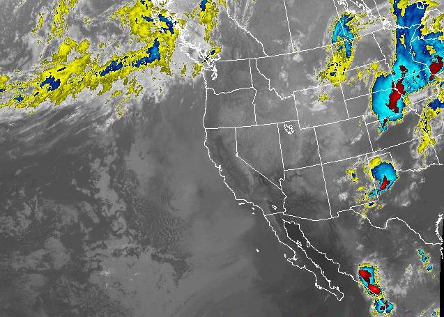
Great waves last weekend slowly tapered off during the week as amazing conditions took hold. Even though the waves have been small the past few days, the wind has been manageable finally.


Tomorrow we have new SW filling in for chest high+ waves in town and shoulder high waves towards the OC. Sunday backs off slightly as the NW winds and windswell start to build in from a cold front up north. Conditions are looking to be pretty bumpy Sunday afternoon unfortunately.


Water temps though are a manageable 67 degrees and tides the next few days are 3' at sunrise, up to 5.5' mid-morning, down again to 0' late afternoon and up slightly to 2' at sunset.

FORECAST:
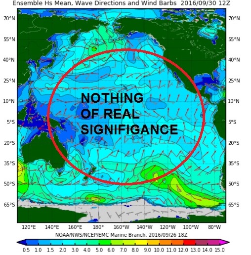
The NW windswell kicks into full gear Monday and Tuesday with head high waves and overhead sets in SD. Unfortunately NW wind accompanies this swell.


Underneath it all is more background SW swell from a storm off Antarctica last week. That peaks on Wednesday but there will still be a lot of leftover bump from the NW windswell early in the week.


After that things slow down considerably with just some background NW/SW. It won't be flat- most likely waist high with chest high sets. A real snoozer compared to this weekend and last weekend. Maybe I'll finally have time to mow the lawn or take a shower. Make sure to keep up to date on any developing storms at Twitter/North County Surf. 

WEATHER:


Crazy week of weather we just had. Actually, this time of year we normally get hot weather- but 100 degrees?! C'mon! High pressure today is slowly being replaced by low pressure up north and we'll get a return of night/morning low clouds this weekend and temps in the high to mid-70's. By Sunday the low pressure up north swings inland of us and the WNW winds kick in. Should have breezy conditions late Sunday into Monday and messy conditions in the surf. High pressure starts to build back in again mid-week and we should have great weather again the 2nd half of next week. Not as hot as we had a few days ago, but temps most likely in the low-80's.

BEST BET:
Tomorrow and Saturday with peaking SW and nice conditions.

NEWS OF THE WEEK:


As we all know, waves pack a lot of power. Even 4’ Teahupoo has enough energy to light up a small town (or light YOU up if caught in the impact zone). So how do we harness that energy? Europe has tried their luck for a number of years but that doesn’t do us any good here across the pond. Until now. Various media outlets (including ABC News below) is reporting Hawaii is throwing they’re hat in the ring to develop clean renewable ocean energy. And who knows better than anyone about ocean energy than Hawaiians? Here’s the scoop:

Off the coast of Oahu, a tall buoy bobs and sways in the water, using the rise and fall of the waves to generate electricity. The current travels through an undersea cable for a mile to a military base, where it feeds into Oahu's power grid — the first wave-produced electricity to go online in the U.S. By some estimates, the ocean's endless motion packs enough power to meet a quarter of America's energy needs and dramatically reduce the nation's reliance on oil, gas and coal. But wave energy technology lags well behind wind and solar power, with important technical hurdles still to be overcome.


To that end, the Navy has established a test site in Hawaii, with hopes the technology can someday be used to produce clean, renewable power for offshore fueling stations for the fleet and provide electricity to coastal communities in fuel-starved places around the world. "More power from more places translates to a more agile, more flexible, more capable force," Joseph Bryan, deputy assistant secretary of the Navy, said during an event at the site. "So we're always looking for new ways to power the mission." Hawaii would seem a natural site for such technology. As any surfer can tell you, it is blessed with powerful waves. The island state also has the nation's highest electricity costs — largely because of its heavy reliance on oil delivered by sea — and has a legislative mandate to get 100 percent of its energy from renewables by 2045.

Still, it could be five to 10 years before wave energy technology can provide an affordable alternative to fossil fuels, experts say. For one thing, developers are still working to come up with the best design. Some buoys capture the up-and-down motion of the waves, while others exploit the side-to-side movement. Industry experts say a machine that uses all the ocean's movements is most likely to succeed. Also, the machinery has to be able to withstand powerful storms, the constant pounding of the seas and the corrosive effects of saltwater. "You've got to design something that can stay in the water for a long time but be able to survive," said Patrick Cross, specialist at the Hawaii Natural Energy Institute at the University of Hawaii at Manoa, which helps run the test site.

The U.S. has set a goal of reducing carbon emissions by one-third from 2005 levels by 2030, and many states are seeking to develop more renewable energy in the coming decades. Jose Zayas, a director of the Wind and Water Power Technologies Office at the U.S. Energy Department, which helps fund the Hawaii site, said the United States could get 20 to 28 percent of its energy needs from waves without encroaching on sensitive waters such as marine preserves. "When you think about all of the states that have water along their coasts ... there's quite a bit of wave energy potential," he said.

Wave energy technology is at about the same stage as the solar and wind industries were in the 1980s. Both received substantial government investment and tax credits that helped them become energy sources cheap enough to compete with fossil fuels. But while the U.S. government and military have put about $334 million into marine energy research over the past decade, Britain and the rest of Europe have invested more than $1 billion, according to the Marine Energy Council, a trade group. "We're about, I'd say, a decade behind the Europeans," said Alexandra De Visser, the Navy's Hawaii test site project manager.

The European Marine Energy Centre in Scotland, for example, has 14 grid-connected berths that have housed dozens of wave and tidal energy devices from around the world over the past 13 years, and Wave Hub in England has several such berths. China, too, has been building and testing dozens of units at sea. Though small in scale, the test project near Kaneohe Bay represents the vanguard of U.S. wave energy development. It consists of two buoys anchored a half-mile to a mile offshore.

One of them, the Azura, which extends 12 feet above the surface and 50 feet below, converts the waves' vertical and horizontal movements into up to 18 kilowatts of electricity, enough for about a dozen homes. The company working with the Navy, Northwest Energy Innovations of Portland, Oregon, plans a version that can generate at least 500 kilowatts, or enough to power hundreds of homes. A Norwegian company developed the other buoy, a 50-foot-wide, doughnut-shaped device called the Lifesaver. Cables anchor the 3-foot-tall ring to the ocean floor. When the sea wobbles the buoy, the cables move, turning a generator's wheels. It produces an average of 4 kilowatts.


Test sites run by other researchers are being planned or expanded in Oregon and California. One of them, Cal Wave, run by California Polytechnic State University, hopes to provide utility-scale power to Vandenberg Air Force Base. The Hawaii buoys are barely noticeable from shore, but developers envision dozens of machines working at once, an idea that could run into the same opposition wind turbines have faced from environmentalists, tourist groups and others. "Nobody wants to look out and see wind turbines or wave machines off the coast," said Steve Kopf, CEO of Northwest Energy Innovations.

PIC OF THE WEEK:


Don't let that dead cow in the foreground scare you off. Can't be an omen, can it? And I'm sure there's a perfectly good reason that no one's out surfing. And are those vultures flying around? Man I must be seeing things. Just to be sure, you paddle out first.

Keep Surfing,

Michael W. Glenn
Cool Under Pressure
Stronger Than I Look
Never Been Called A Kook. Not To My Face Anyway

Thursday, September 22, 2016

THE Surf Report- Early Edition


Where do I start?

SURF:


Had some interesting waves/weather this past week due to Hurricane Paine. Not the biggest storm- it only peaked at 90 mph- but it was aimed straight at us and sent some muc needed showers too. Today was the complete opposite as Paine died and a cold front up north kicked in NW windswell for shoulder high sets this afternoon and sunny breezy conditions. And if that's not odd enough, this weekend will be completely different than the first 2 scenarios above. Confused? Should be.


For the weekend we've got NW windswell hanging around as well as a new SW filling in tonight. Both swells will produce head high sets as well as clean conditions and light offshores in the AM.


The SW starts to back off on Sunday but late in the afternoon we have more NW groundswell showing up- best in SD- but still shouder high sets in north county SD from the combo swells.


Tides the next few days are 4' at sunrise, down to 2.5' before lunch, and up to 5' at sunset. Water temps have rebounded slightly to 67 but the offshores this weekend may change all that. Be leery before jumping in.

FORECAST:


If you're arms aren't tired after this weekend, you will be by next week. The late Sunday NW mentioned above lingers into Monday then we've got more SSW on the charts for shoulder high sets late Tuesday into Thursday morning.


And then... models show a new hurricane forming off Baja mid-week which should give us chest high+ waves in north county SD and overhead waves in the OC around the 28th into the 29th. What's interesting about this new hurricane is that it's forecasted to sit offshore of Baja for a couple days. So instead of a 6 hour swell like Paine, we may have a couple day's worth.


We get a little hiatus after that then models show another S swell from the southern hemisphere around the 6th of October. Fall is the best season of the year (I also said that a few months ago about summer so take it with a grain of salt). Make sure to keep up to date on any developing storms at Twitter/North County Surf. 

WEATHER:


Normally I'd be astonished at all the rain we got on Tuesday BUT... last summer was an El Nino year and we got a ton, so this week's rain wasn't a big shock. Most spots in north county received 1/4" to 1/3" and the local mountains received a whopping 1.75" thanks to former Hurricane Paine. All that moisture yesterday was replaced by a very fall-like cold front today and that will be short lived as high pressure sets up tomorrow through most of next week. Look for nice conditions tomorrow and then amazing weather Saturday through Monday with sunny skies, temps in the 80's, and light offshores in the AM. High pressure starts to breakdown late next week for cooler temps and more clouds.

BEST BET:
This weekend with a variety of swells, offshore winds, and not a cloud in sight.

NEWS OF THE WEEK:


Whether you believe in global warming or not, the fact is that the earth is getting hotter. Are we just in a naturally occurring warm phase in time and greenhouse gases are not the cause? Who knows. Maybe the sun is just getting slightly bigger each year (oh joy). Regardless, the National Oceanic and Atmospheric Administration has some info for you to ponder:

Put away your party hats: August marks a not-so-sweet 16 months of record warmth for the globe, the longest such streak in 137 years.  August 2016 was 1.66 degrees F above the 20th-century average, breaking last years’ record for the warmest August on record by 0.09 degrees F, according to scientists from NOAA’s National Centers for Environmental Information. The June–August seasonal temperature was 1.6 degrees F above average, surpassing the heat record for this period set in 2015 by 0.07 degrees.

For the year to date, the average global temperature was 1.82 degrees F above average, also breaking the heat record set in 2015 by 0.29 degrees.
More notable findings around the world include:

The globally averaged sea surface temperature was second warmest on record for August and warmest on record for both the season (June–August) and the year to date (January–August).
The globally averaged land surface temperature was record high for August, the season (June–August) and the year to date (January–August).
Record-warm continents: Africa and Asia had their warmest August; South America had its second; North America its sixth; Europe its 10th; and Oceania its 19th.
The average Arctic sea ice extent for August was 23.1 percent below the 1981–2010 average. This was the fourth smallest August extent since records began in 1979.
The average Antarctic sea ice extent for August was 0.2 percent above the 1981–2010 average, the 19th largest on record for the month.

So there you have it. If your bucket list has surfing Alaska with Mason and Mick in a 6/5/4 fullsuit- do it quick before it’s the next Oahu.

PIC OF THE WEEK:


I mentioned a few weeks ago that if Trump wins, it's rumored a lot of Americans will move to Canada. With waves like this though, I'll move to New Zealand; regardless if Trump OR Clinton wins.

Keep Surfing,

Michael W. Glenn
Futuristic
Patriot's 4th String QB
My Ancestors Invented The Surfboard

Thursday, September 15, 2016

THE Surf Report- Early Edition


Swell of the CENTURY last weekend!

SURF:
Was a dud. That's the last time I use the Emergency Boardriding System alert.


Plenty of swell but unfortunately plenty of NW wind. So much wind in fact that our water has dropped to the mid-60's. Right where it should be this time of year but alas no more trunks for you and I. Tomorrow we have small leftover Hurricane Orlene S swell and lingering NW swell for waist high+ surf.

Saturday stays about the same but new small SW starts to fill in towards the evening.


Sunday we have chest high sets as new early season NW groundswell filld in late in the day and mixes with the SW. Long story short, small on Saturday and kind of rideable Sunday.


Tides the next few days are 3' at sunrise, up to 5.5' mid-morning, down to almost 0' mid-afternoon, and up to 4' at sunset.

FORECAST:
The NW mentioned above on Sunday hangs around on Monday while the SW backs off.
Tuesday/Wednesday look small but by Thursday afternoon we start to get some SW again from the southern hemisphere. Last week the forecast models looked impressive but when the storm actually formed, it wasn't that big. So we'll have shoulder high sets towards the OC and chest high waves down here on Friday. That lasts through the weekend. Models also show some NW arriving around the same time too but we'll have to wait and see.  Make sure to keep up to date on any developing storms at Twitter/North County Surf. 

WEATHER:


I'm over these fall-like conditions at the end of summer. Can't fall just wait another week for it's turn?! First our water temps drop then our air temps. Criminy. Looks like we'll have some fun around here the next few days though. First up is strengthening high pressure this weekend which will raise our inland temps to 90 but may trap our fog at the coast for most of the day. The real excitement though is tropical moisture headed our way towards Monday which may bring a stray shower to the coast. Remember the tropical activity in our skies last summer? Think that. Things should clear out mid-week for seasonal temps and night/morning low clouds/fog again. Boring.

BEST BET:
Sunday with small combo swell or late next week with hopefully slightly bigger combo swell.

NEWS OF THE WEEK:


I swear. Trying to figure out the weather is like trying to figure out women: It can’t be done. The result is always the same- I’m always the one in the wrong. Take for example our ‘big’ El Nino of 2014. All the signs pointed to a warming Pacific and torrential rains for Southern California- then zilch. Then in 2015 all the signs pointed to a warm Pacific again and the forecasters said ‘this time we’re going to get dumped on down here- trust me’. And then nada. Then we saw the Pacific cooling off this summer and we must be headed towards La Nina this winter, right? Wrong. Latest report from the National Weather Service (NOAA) says the following:

“Since the demise of the big 2015-16 El Niño in April, the tropical Pacific has been loitering around in neutral… and now forecasters think it’s likely to stay that way through the winter. For now, we’re taking down the La Niña Watch, since it no longer looks favorable for La Niña conditions to develop within the next six months.

What happened?
Over the last few months, sea surface temperature anomalies (the departure from the long-term average) have become more negative, which was expected (i.e. trending towards La Nina conditions).  Currently, the sea surface temperatures  are about -0.5° below the long-term average.


But this is the La Niña threshold! However, the second step of the La Niña conditions decision process is “do you think the SST will stay below the threshold for the next several overlapping seasons?” For now, the answer to this question is “no.”

In fact, the climate models are predicting that this month’s anomaly will be the low point, and sea surface temperatures will recover to near average over the next few months. There is still a range of forecasts, but all eight of the North American Multi-Model Ensemble models expect the negative anomalies to weaken toward zero.

What didn’t happen?
Here at the NOAA, we talk a lot about the response of the atmosphere to the change in sea surface temperatures. That’s because both are intertwined. Just like El Niño, La Niña requires an atmospheric response, and it just hasn’t happened over this summer.

For La Nina, even more than usual, cooler air sinks toward the surface over the cooler-than-average waters of the central and eastern Pacific. Meanwhile, the perpetually warm waters near Indonesia warm further, and the overlying air becomes even more warm and buoyant than usual, leading to more vigorous convection (rising air).

These opposing areas of vigorous rising and sinking air amp up the normal circulation across the tropical Pacific: at the surface, stronger-than-average winds blowing east to west, and high up in the atmosphere, corresponding stronger-than-average winds blowing west to east.  More rain falls over Indonesia, and less falls over the Central Pacific.

So far, there have only been some very weak indications of this intensification, like a small area of stronger-than-average upper level winds over a localized region of the central Pacific. Also, some extra rain over western Indonesia, and a narrow, but weak, strip of drier-than-average conditions over the cooler waters of the central Pacific.

But what needs to happen to really get La Niña conditions underway is for those stronger-than-average winds to blow across the surface of the equatorial Pacific, cooling the surface and helping to keep warm waters piled up in the far western Pacific. We’ve seen some weak bursts of this activity over the past few months, but nothing has settled in for the long haul.

Without this atmospheric feedback, the large area of cooler subsurface waters that we saw back in the late spring has decreased substantially. Yes, the surface has cooled, but there’s not much cool subsurface water left to extend or intensify the conditions.


What’s going to happen?
It’s certainly not impossible that La Niña could still develop; forecasters are putting the chances for La Niña somewhere around 40% through the early winter. And, while a strong La Niña developed immediately after the monster 1997/98 El Niño, there was nearly a year of slightly-below-average temperatures following the other monster 1982/83 El Niño before a moderate La Niña eventually developed in October of 1984, further evidence that there are many pathways that the climate system can follow after a large El Niño event.

For now, though, most signs are pointing toward a stronger chance of remaining in neutral conditions for the time being. Between the model consensus and the current lack of atmospheric response, forecasters put the odds of staying Neutral at 55-60%.”

So what does that mean for us in Southern California? 3 things: Our water temps should stay average this winter (in the high 50’s vs. the low to mid-50’s so a 4/3 fullsuit may not be needed), average rainfall around here, about 10” (better than a drought I guess), and average consistency of surf this winter (i.e. not a parade of big storms like El Nino but not flat either). Of course I’ll be wrong on these 3 predictions too.

PIC OF THE WEEK:


If this wave came barrelling down on you, would you paddle faster to the channel? Or be a deer in the headlights?

Keep Surfing,

Michael W. Glenn
All I Do Is Win
Just Wanted To Give Lochte A Hug
Voted World's Best Freesurfer

Thursday, September 8, 2016

THE Surf Report- Early Edition


Swell of the CENTURY this weekend!

SURF:

Alright alright. I used that joke last week. But I can now activate the Emergency Boardriding System alert because we finally have good waves. New SW started showing on the buoys last night and filled in further today with shoulder high sets in town and head high+ waves towards the OC. The swell builds further on Friday and tops out in the afternoon with head high sets and overhead waves at best SW spots. That holds into Saturday morning. Swell unfortunately is a little lined up as we don't have much NW windswell in the water to cross things up. Sunday drops off to the chest high range but it's still rideable- along wth nice weather this weekend.


Water temps are holding at 70 and tides the next few days are mellow; about 3' at sunrise and almost 5' at supper time.

FORECAST:


The beginning of the work week starts off pretty small but more SW heads our way towards the end of the week. Friday looks to have chest high waves again with maybe a shoulder high set in the OC.


Models also show an early season small NW hitting about the same time for waist high sets and slightly bigger in SD. There's also a small hurricane forecasted to form mid-week which may give us waist high+ surf in north county SD by the weekend and chest high+ sets in the OC. All in all, next Friday through Sunday will have a variety of swells for fun waves.


Further out  there's another early season Aleutian storm on the charts which could give us chest high waves from the NW towards the 18th.

And after that... models show a good storm off Antarctica which MAY give us overhead+ SW towards the 23rd. Make sure to keep up to date on any developing storms at Twitter/North County Surf.

WEATHER:


Pretty typical weather around here for the next week. High pressure builds slightly this weekend for less clouds and temps in the mid-70's. Then low pressure comes back early next week for a little more clouds and cooler temps. Then weak high pressure returns late next week for less clouds again and temps, wait for it, about mid-70's. I wish I had a job as a weatherman in San Diego. Easy money.

BEST BET:
Tomorrow with peaking SW.

NEWS OF THE WEEK:


Amaze your friends with these amazing facts!

Sandy beaches are mostly made of silica (SiO2) in the form of the mineral quartz.
The size of the sediment found on a beach is a good indication of the wave and wind energy in the area. Shorelines that are protected from waves and winds usually have finer sediment than exposed coastlines where small sediment is suspended within the turbulent waters.
Steep beaches have a strong wave backwash that pulls material down the beach slowly making the slope gentler. Waves on beaches that have a gentle slope run up the beach powerfully, before falling back gently, therefore depositing material at the top, which slowly makes the beach steeper.
The longest beach in the world is arguably Praia do Cassino (Casino Beach) in the city of Rio Grande, Brazil. It is approximately 132 miles long.
Fraser Island off the coast of Queensland, Australia, is the largest sand island in the world covering around 630 square miles and has a beach 40 miles long.


Around 70% of the Earth’s surface is covered by oceans.
The world’s oceans contain enough water to fill a cube with edges 621 miles in length.
While there are hundreds of thousands of known marine life forms, there are many that are yet to be discovered, some scientists suggest that there could actually be millions of marine life forms out there.
The largest ocean on Earth is the Pacific Ocean, it covers around 30% of the Earth’s surface.
The Pacific Ocean’s name has an original meaning of ‘peaceful sea’. Which is accurate considering how small the surf has been the past few weeks.
Located to the east of the Mariana Islands in the western Pacific Ocean, the Mariana Trench is the deepest known area of Earth’s oceans. It has a deepest point of around 36000 feet.


The Pacific Ocean contains around 25,000 different islands, many more than are found in Earth’s other oceans.
The second largest ocean on Earth is the Atlantic Ocean, it covers over 21% of the Earth’s surface.
The Atlantic Ocean’s name refers to Atlas of Greek mythology.
The third largest ocean on Earth is the Indian Ocean, it covers around 14% of the Earth’s surface.
During winter the Arctic Ocean is almost completely covered in sea ice.
While some disagree on whether it is an ocean or just part of larger oceans, the Southern Ocean includes the area of water that encircles Antarctica.
According to the Guinness World Records, the tallest sandcastle ever made was constructed in Connecticut, USA, in May 2011 and was 37 ft 10 in tall.

PIC OF THE WEEK:


You know how warped this wave is? The photo seems tilted when you look at the wave then you see the horizon is actually straight. That wave is sucking below sea level so hard it's draining off the reef like a waterfall. Yikes.

Keep Surfing,

Michael W. Glenn
Steady As A Rock
Pre-ordered the iPhone 8
Rick Kane's Stunt Double

Thursday, September 1, 2016

THE Surf Report- Early Edition


Swell of the CENTURY this weekend!

SURF:
This is a test of the Emergency Boardriding System. If we had real surf coming this weekend, you would have actually seen that alert. But alas, we're going to be on the slow side the next few days. But when we do get overhead surf, by golly you're going to get an ear full from me.


But before I completely write off the Labor Day Weekend, let's step back in time and have a look at the past week. There were some fun NW/SW combo peaks to be had on the right tides along with cool weather. This weekend looks to be the same- about a foot or two smaller unfortunately- but best spots may pull in the occasional chest high set. Most likely we're looking at waist high+ surf.


Monday though sees the surf pop back up to the chest high range from a touch of new SW and NW. My advice is get your honey-do's done on Saturday/Sunday (or at least watch college football) and get some surf Monday afternoon. Water temps have rebounded slightly to 70 degrees.


Tides the next few days are 1' at sunrise, up to 5' late morning,  down to 1' again late afternoon, and up slightly to 3' at sunset.

FORECAST:

Fun little waves hang around on Tuesday and Wednesday/Thursday look to be small. BUT... we have a good storm off Antarctica today which will send us good surf late Thursday into the weekend. Might see an overhead set from this one. Jinx! The Lowers contest should be firing. Avoid Trestles at all costs unless you light getting snaked by the top 32. We should also have small background NW swell all week to break up the SW.


Further out, models show also show a small hurricane off Baja around the 9th which may give us chest high sets towards the 12th (and shoulder high sets in the OC). Then models again show another solid storm off New Zealand around the 9th which would give us head high waves towards the 16th. Looks like I might have to use that Emergency Boardriding System alert after all. Make sure to keep up to date on any developing storms at Twitter/North County Surf. 

WEATHER:


Isn't Labor Day supposed to be the official end of summer party? Then how come our weather will stink this weekend?! We have a weak storm up N which will- you guessed it- kick up the clouds down here. Fog/low clouds will taken longer than expected to burn off at the coast and temps will be slightly below average- just about 70. High pressure should build the middle of next week though for a slight warm up- just in time for that new swell.

BEST BET:
Monday if you're desperate or next Friday with better weather and solid SW swell.

NEWS OF THE WEEK:


With the East Coast of the US getting its fair share of hurricane activity this week- not to mention the Hawaiian Islands- I thought us Californians were due for a late season Eastern Pacific update. But first, where exactly is the Eastern Pacific and are we due for more storms this season?

The Eastern Pacific hurricane region covers the Eastern Pacific Ocean east of 140 degrees W- north of the equator. This area is one of the most prolific tropical storm formation regions in the world. Eastern Pacific tropical storms most often track westward over open waters, sometimes reaching Hawaii (as in the case of Madeline and Lester this week) and beyond. However, some storms occasionally head toward the northeast, bringing rainfall to the arid southwestern United States during the summer months (last summer was a good indication of this). Also, during any given season, tropical storms can affect western Mexico or Central America, especially early and late in the season


The official Eastern Pacific hurricane season runs from May 15th through November 30th. The peak activity typically occurs during July through September. And based on West Coast water temps, our peak is the end of August- sorry people- we’re headed toward fullsuit season. During the period 1981-2010, the Eastern Pacific seasonal averages were 15.4 named storms (maximum 1-minute surface winds between 39-73 mph), with 8.4 of those becoming hurricanes (maximum 1-minute surface winds of at least 74 mph) and 3.9 becoming major hurricanes (maximum 1-minute surface winds exceeding 111 mph, categories 3-5 on the Saffir-Simpson hurricane scale).

Eastern Pacific hurricane seasons exhibit long periods of above- normal and below-normal activity in response to large-scale climate patterns. Seasons also exhibit year-to-year variability in response to ENSO. El Niño contributes to decreased easterly vertical wind shear and favors above-normal hurricane activity in this region. Historically, El Niño is not associated with below-normal seasons. Conversely, La Niña contributes to increased vertical shear and less overall activity. Historically, 60% of La Niña episodes have been associated with below-normal hurricane seasons, and only 28% have produced an above-normal season. However, the ENSO impacts can be strongly influenced by the background climate patterns. As a result, NOAA accounts for the combined influences of both climate factors when making its seasonal hurricane outlooks.

The phrase "total seasonal activity" refers to the collective intensity and duration of eastern Pacific named storms and hurricanes occurring during a given season. The measure of total seasonal activity used by NOAA is called the Accumulated Cyclone Energy (ACE) index. The ACE index is a wind energy index, defined as the sum of the squares of the maximum sustained surface wind speed (knots) measured every six hours for all eastern Pacific named systems while they are at least tropical storm strength.

Reliable tropical storm and hurricane data for the eastern Pacific began in 1971. The 1981-2010 mean value of the ACE index is 113.3 x 10⁴ kt2, and the median value is 100.4 x 10⁴ kt2. The following season classifications are based on an approximate 3-way partitioning of seasons based on the ACE value, combined with the seasonal number of tropical storms, hurricanes and major hurricanes.

Above-normal season: An ACE index above 115 x 104 kt2 (115% of the median) and at least two of the following three conditions: 17 or more named storms, 9 or more hurricanes, and 5 or more major hurricanes.

Near-normal season: An ACE index in the range 80-115 x 104 kt2 (80%-115% of the median), or an ACE value higher than 115 x 104 kt2 but with less than two of the following three conditions being met: 17 or more named storms, 9 or more hurricanes, and 5 or more major hurricanes.

Below-normal season: An ACE index below 80 x 104 kt2 (80% of the median).

That’s all fine and dandy and if you’ve read through all that, then you must have loved school. So now to the good part- where are we at today?


Six named storms formed during the month of August, but only one of these became a hurricane in the Eastern North Pacific basin.  The one hurricane, Lester, also became a major hurricane.  Although the total number of storms and major hurricanes in August is considered near or above average, the number of actual hurricanes (i.e. not tropical storms) was below average. Based on a 30-year (1981-2010) climatology, three named storms typically form in the basin in August, with two of those becoming hurricanes and one reaching major hurricane intensity.


BUT… in terms of the Accumulated Cyclone Energy (ACE), August ACE was near average. Which is a good sign considering forecasters were calling for a below average season as we transitioned from El Nino last spring to La Nina this fall. AND… the ACE for the season to date continues to be well above normal, about 175 percent of the long-term average to date. An average La Nina season (i.e. bad) is 13 named storms and we’ve already had that with a couple months to go. We also should have only had 3 majory hurricanes in a bad year and we’ve had 4 already- with again- a couple months to go. My theory is that the El Nino was so strong and water temperatures so warm the past 2 years, it’s taken the ocean forever to cool down. So there’s still a lot of energy out in the Eastern Pacific to contribute to hurricane formation. Which is a good thing as we go through our last month of the peak season in September.

PIC OF THE WEEK:


My two favorite things in the whole wide world are represented in this photo- waves and weather! Oh- and I also love my wife. Had to include that. Close one there. Oh- and my kids! Almost forgot that too. Whew! And those Hostess apple pies. Man I love those. And finding change in my couch. So rad. And smiling. Smiling is my favorite. I'm off track here. Anyway, have a great Labor Day Weekend.

Keep Surfing,

Michael W. Glenn
On the Up and Up
The Voice of Clarence
Live to Surf. Surf to Live