Sunday, August 28, 2022

North County New Business News: Cycle, Cocina, and Coffee


I apologize, but it's been too long. The North County Surf blog was set up over a decade ago (11 to be exact) to let me ramble on about things that interest me in and around North County. Whether it was wave & weather conditions to plan your weekend, new housing being built, bargains to be had, best beaches for groms, or the possibility of a wave pool in our neighborhood (almost 10 years later), I've neglected to post anything in a LOOOONG time about new businesses popping up. So here goes! Drumroll please...

First up is the old Lumberyard Tavern in the Lumberyard shopping center (in downtown Encinitas). One of my favorite places to grab a burger and a brew (rest in peace Priority Public House, Islands, Chilis, Hamburger Hula, Denny's, etc. etc. etc.), it was closed during the pandemic and unfortunately didn't open back up. 

Located at the southern end of the Lumberyard shopping center (across from Fish Shop and next to Cardiff Classics auto sales), the corner location and outside seating is prime. 

I came across the permit on the window this weekend and the new occupant is going to be Cocina de Barrio. If you're not familiar with the restaurant, they have 2 locations in San Diego- Hillcrest and Point Loma. And before you say 'oh no, another taco shop'- it's not. Lucky for us North County residents, Cocina de Barrio was a 2022 critics pick in San Diego Magazine for one of the top restaurants. So yes, it will be a sit down restaurant- with cocktails might I add. They even serve brunch and have a happy hour. Now I don't know what the exact menu will be, but have a look at their website and what they serve at the other 2 locations- I'm guessing it will be similar. I also don't know how the remodel/permit process is going, but I'm guessing it won't be open until later in the fall. 


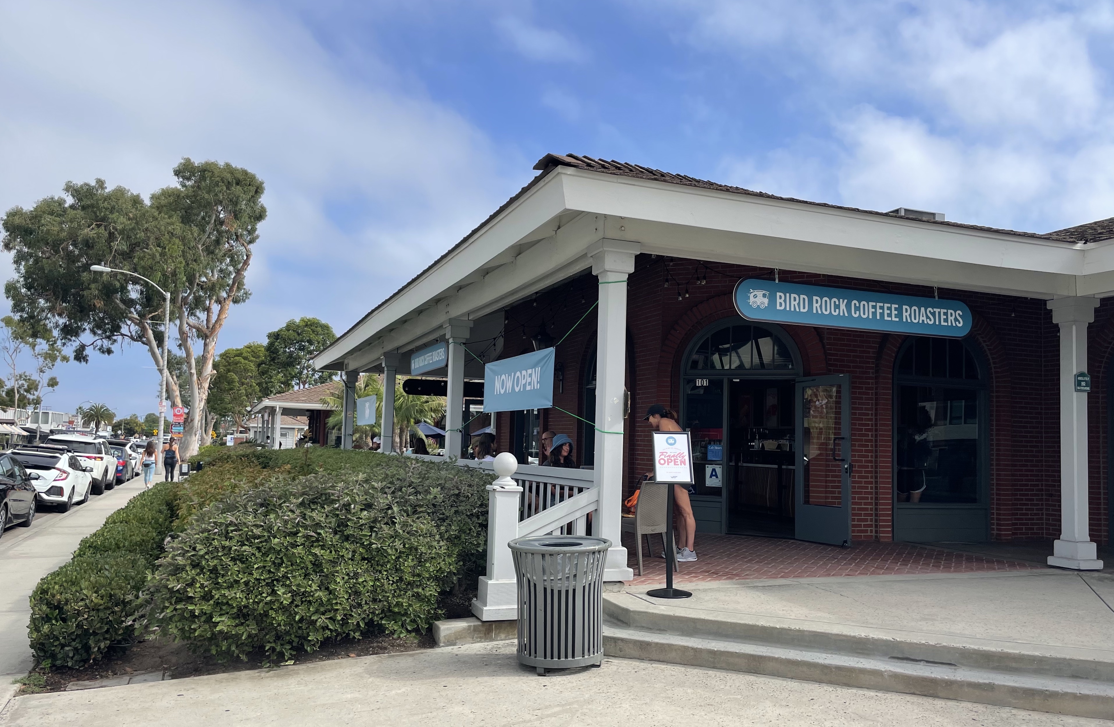
Also new to the Lumberyard in Encinitas is Bird Rock Coffee Roasters. Seems like everyone down south is moving north for the winter- even the Bird (sorry- bad joke). With 8 locations in San Diego, the old Starbucks was the logical location for their next store. 


Winners of various coffee awards, it's nice to see another SD company move into the location. It's amazing how many coffee houses we have in Encinitas- and all of them are fairly busy. Besides being a place to grab a quick cup of joe or a bite, they're a neighborhood hangout. So the sense of community is appreciated. I think all the coffee stores should put together a softball rec league and we can watch Lofty Coffee, Philz, Java Dog, French Corner, Better Buzz, Ironsmith, Pannikin, Queenstage, Bird Rock, Coffee Coffee, Gordy's, Zumbar, and Starbucks (pick your location) battle it out for best cup of coffee! 


And of course with a lot of coffee shops, you can pick up a last minute birthday gift. 


And last but not least, what the heck in going on in that big brick building at the south end of downtown Encinitas? With various tenants over the years- the last being Electra Bike's headquarters- the new space is almost done being remodeled into...


A Trek Bicycle superstore?! But I thought they somewhat recently took over the old Nitro store in downtown Encinitas?


They did. But... it was a fairly small store for the amount of bikes in the Trek family. Even though Trek is known for having some of the best high end road bikes in cycling, they also make mountain bikes, electric bikes, kids bikes, beach cruisers under the name Electra (big fan- I've got 3), apparel, accessories, etc. This new store is going to be a 1 stop shop for the weekend cruiser up to the pro and it's a BIG retail footprint with LOTS of stock. They also will have a service center. Rumor has it they're aiming to open for the Labor Day weekend. So if you're cruising the coast in your car, make sure to stop by- and pick up a bike instead. 


Thursday, August 25, 2022

THE Surf Report


We're About To Reach The Summit

SURF:
If you're superstitious, just pass over the next few sentences because I may jinx your weekend surf plans. For those of you who don't believe in those sorts of things: 


How good do we have it rignt now? Fun combo surf the past few days, warm air temps, light winds, sunny skies, and water temps in the mid 70's?! Does it get any better than this? Just when you think it couldn't get any better, along comes this weekend. 


A solid storm off Antarctica mid-month has sent us good SW swell for the weekend. Look for chest high+ surf later tomorrow in northern SD and shoulder high surf in the OC. For Saturday, the swell peaks with head high+ waves in northern SD and overhead sets in the OC. Sunday starts to drop but there's still plenty of good surf (and sunny skies and warm water, blah blah, blah). We also should have a little NW windswell building for the weekend which will help break up the lines at the beach breaks. And here's the tides, sun, and water temps for the next few days:
  • Sunrise and sunset:
    • 6:20 AM sunrise (6 AM paddle out?)
    • 7:19 PM sunset (7:30 PM paddle in?)
  • Water temps are holding at 75. Bam! 
  • And tides are pretty boring (again) this weekend:
    • 1' at sunrise
    • 4.5' late morning
    • down to 1.5' late afternoon
    • and back to 4' at sunset
FORECAST:

The good swell from the weekend fades early next week but you might be able to find some chest high surf early on. 


Towards Thursday, we get a small reinforcement from the S for more waist to chest high waves. 


And further out, we may see another good SW swell for shoulder high+ surf towards the 6th (along with more NW)? As far as the tropics are concerned, that taste of Chubasco early in the summer is gone and La Nina is back in control. 

WEATHER:


Humid weather will decrease over the weekend but we'll still have air temps in the low to mid 70's along the coast. By mid-week, we warm up again as high pressure builds and beaches are back to the high 70's. All the while, low clouds and fog will make an appearance in the nights and mornings. If anything changes between now and then, make sure to follow North County Surf on Twitter!


BEST BET:

This weekend will be worthy of the Emergency Boardriding System. Flip that switch! 

NEWS OF THE WEEK:


Even though sharks make unfortunate mistakes sometimes (i.e. biting surfers), they are an important part of our ecosystem and the health of our oceans. Adult great whites may look scary with their sharp teeth and lengths of 15-20', but for the most part, they swim far away from shore. The real predator in the oceans though are orcas who have been known from time to time to attack great whites (and leave humans alone as far as I know). With their intelligence and lengths up to 30', they roam freely in the oceans. But it hasn't been that way forever as scientists think the Megalodon (a favorite subject of mine) may have snacked on Orcas over 20 million years ago. Which means they were mighty big. 

New research led by Jack Cooper, a paleobiologist at Swansea University, concluded that megalodons were faster than any shark alive today and big enough to eat an orca in just five bites and was an even more impressive superpredator than scientists realized before. Here's what they found:

The Otodus megalodon, the inspiration behind the 2018 film "The Meg," lived more than 23 million years ago. Fossils of the extinct giant are hard to come by: While there are plenty of fossilized shark teeth, their bodies mainly consist of cartilage rather than bones, and are rarely preserved. Paleobiologist Jack Cooper set out to use 3D modeling from a rare and exceptionally well-preserved megalodon spinal column to extrapolate information about the shark's movement and behavior. Their research was published in Science Advances last week.


"We estimate that an adult Megalodon could cruise at faster absolute speeds than any shark species today and fully consume prey the size of modern apex predators," wrote the researchers. Most of what we know about megalodons come from scientific inferences: Scientists have estimated the extinct sharks could be as long as 65 feet through a comparison with great white sharks, thought of as their "best available ecological analog," since they both occupy the top rung in the food chain, according to the article. (For comparison's sake, Great Whites above 20' are rare and the shark in the movie Jaws was an exaggerated 25', so yes, a 65' shark is mind boggling).

The researchers used a megalodon vertebral column from Belgium, a tooth from the United States, and the chondrocranium -- the cartilaginous equivalent of a skull -- from a great white shark to build their 3D skeleton. Then they used a full-body scan of a great white shark to estimate how flesh would sit on the megalodon's skeleton.

With a complete 3D rendering, they came up with estimates for the volume and body mass of the shark's whole body. By comparing the figures to the size of modern sharks, they estimated the shark's swimming speed, stomach value, calorie needs, and prey encounter rates.

The particular megalodon they modeled would have been almost 16 meters, or 52 feet, long. It weighed around 61,560 kilograms, or 135,717 pounds, according to their estimates (around 67 tons- which is about 2 fully loaded semi trucks. Holy cow). 


They estimated the megalodon would have been able to devour prey the size of orca whales -- which can be up to 26 feet long and weigh over 8,000 pounds -- in just five bites. Prey the size of a modern humpback whale would have been too big for a megalodon to eat in full, according to the researchers. Eating large prey may have given the megalodon a competitive edge over other predators. Eating large amounts at a time would have also allowed them to travel great distances without eating again, much like modern great white sharks.

An adult megalodon would have needed to eat a whopping 98,175 calories per day (and the FDA says adult humans should consume around 2,000 calories a day), 20 times higher than an adult great white shark. They could have met their energetic needs by eating around 31.9 kilograms of shark muscle, according to the researchers' estimates.

The megalodon was also faster than any shark alive, with a theoretical average cruising speed of around 3.1 mph. This speed would have allowed it to encounter more prey, helping it meet its massive caloric demands.

Overall, the data extrapolated from the 3D model paints the portrait of a "transoceanic superpredator," say the researchers. Luckily, today's orcas don't have to worry about running into the massive shark. The megalodon went extinct around 3.6 million years ago, according to the United Kingdom's Natural History Museum, for reasons scientists are still trying to understand.

So the next time you paddle out to some offshore reef in the early morning hours- don't worry- there's no megalodons around. 

PIC OF THE WEEK:


Keep Surfing, 
Michael W. Glenn
Never Been The Underdog
3X VMA Winner
Proud To Be A Grom


Thursday, August 18, 2022

THE Surf Report


Warm Water, Please Don't Leave

SURF:
Had a conversation with a friend of mine last week in which we concluded that warm water solves everything. Small surf? No problem- water's warm. A bit windy? No problem- water's warm. One too many shredders in the line up? No problem... water's warm. Today the NW wind is blowing unfortunately, increasing the risk for cold water upwelling, so let's keep our fingers crossed this weekend that the wind turns to the SW! 


As far as the surf goes, the past few days have been small in SD while the OC has seen chest high waves from a straight S swell. But SD will get in on the action this weekend- from the NW none the less- as some NW windswell builds tomorrow into Saturday and mixes with the small S. Look for chest high sets... and warm water. Sunday drops back to the waist high range. And here's the tides, sun, and water temps for the next few days:
  • Sunrise and sunset:
    • 6:16 AM sunrise 
    • 7:28 PM sunset
  • Water temps (for now) are near the mid 70's in SD and low 70's in OC. If the wind continues from the NW the next few days, look for temps in the high 60's by the end of the weekend...
  • And tides are pretty boring this weekend:
    • about 3' at sunrise
    • 5' in the evening
    • and about 4' at sunset

FORECAST:


Still nothing big on the horizon but it looks like the N Pacific is trying to come to life- one month before the official start of fall. 


First up is a fun SSW swell arriving late on the 22nd which will be joined by NW groundswell on Wednesday the 23rd resulting in chest high+ surf. 


Following that is another combo swell with SW arriving the 26th and NW the 27th. Look for this to be slightly better with shoulder high+ surf. All in all some fun swells on the horizon while the tropics stay quiet. 

WEATHER:


Quite the summer for monsoon moisture in the mountains and deserts. Big Bear alone received 4" of rain in some locations just this past Tuesday. Looks like another surge of clouds will head our way for the weekend and the middle of next week. We most likely won't see rain along the coast but those big cumulonimbus clouds will be visible in the distance. Here along the coast, look for patchy fog in the nights/mornings and air temps in the mid-70's. If anything changes between now and then, make sure to follow North County Surf on Twitter!

BEST BET:

This weekend we'll have small but fun NW windswell in SD but best bet is to wait until next Tuesday and Friday with better combo swell.

NEWS OF THE WEEK:


As was predicted decades ago with climate change, the weather is getting more extreme. Instead of a nice steady rain all winter, we get all of it at once (for you N County SD residents- remember mid-April 2020 where we received 7 1/2" of rain in 6 days)?! While we've really only had to deal with extreme heat the past few years in California (Death Valley over 130 degrees and 8 of 10 of the largest wildfires on record have happened the past 5 years), scientists are now predicting we're due for the opposite- a megaflood.

California experiences on average a megaflood 5-7 times every 1,000 years (the last one being in1862); but this new report shows increased odds as the earth gets warmer this century. Here's what CBS News reported this week:

Devastating wildfires and droughts are not the only natural catastrophes that California will continue to face. According to new research published on Friday, a disastrous megaflood could bring so much water to some areas of the state that it could completely drown entire stop signs on a neighborhood street. 

Scientists say it's part of an investigation into a "plausible worst case scenario." Their research, published in Science Advances, focused on two extreme flooding scenarios: one based on recent historical climate data and another that's based on the projected climate for the end of this century, from 2081-2100. Using climate models and high-resolution weather models, scientists found that California should brace for possible impact in the coming decades.

The historical model, known as ArkHist in their study and based on data from 1996 to 2005, a megaflood could bring a maximum of 85 inches to California's Sierra Nevada. Under this scenario, the state would also see higher precipitation intensities, with coastal areas having eight out of 30 days and mountain areas having 14 out of 30 days be "heavy precipitation." Overall, broad regions could expect more than a foot-and-a-half of precipitation, with widespread areas in the Sierra Nevada and some spots in the Coast ranges, Transverse Ranges and Cascade Range seeing more than double that.


UCLA climate scientist and research co-author Daniel Swain said in a UCLA press release that in the future modeling, "the storm sequence is bigger in almost every respect. There's more rain overall, more intense rainfall on an hourly basis and stronger wind," he said. 

Under the future model, which is based on a scenario of the continued rapid growth of greenhouse gas emissions and global warming, precipitation would accumulate from more than two feet to more than two-and-a-half – essentially double what the state would see under the historical model. Coastal areas would face 16 days and mountain areas would face 20 out of 30 days of heavy precipitation, with some areas of the Sierra Nevada and southern Cascades seeing a full month. There is also a 220% increase in heavy precipitation hours.

This future modeling could be disastrous for some localities.  "There are localized spots that get over 100 liquid-equivalent inches of water (8.3 feet) in the month," Swain said in a UCLA press release. "On 10,000-foot peaks, which are still somewhat below freezing even with warming, you get 20-foot-plus snow accumulations. But once you get down to South Lake Tahoe level and lower in elevation, it's all rain. There would be much more runoff." In his own analysis of the research, Swain said that the primary concern for these findings is the increased runoff into rivers and streams, which increases the risk of floods. 


Their research found that under the future high emissions scenario, runoff is 200 to 400% greater than historical values – numbers that will have massive implications for the Sacramento and San Joaquin River flood plains. These areas, Swain said, are the home of ancient flood deposits, as well as millions of Californians. 

"Flood risk during an event like either of these scenarios will bring widespread and severe flood risk to nearly the entire state," Swain said, "but the extreme increases in projected surface runoff in the Sacramento and San Joaquin basins are of particular concern given the confluence of high pre-existing risk in these regions and a large population that has never experienced flooding of this magnitude historically."

Both of the scenarios paint a grim forecast but climate change and humans continuing to feed global warming through greenhouse gas emissions are only going to make the outcome worse, the researchers said. They found that for every 1ºC of global warming, the annual likelihood of an event based on their historical modeling increases rapidly. As of this year, climate change has already increased the likelihood of such an event by about 105% compared to 1920. 

And if the world continues on a path of high emissions over the next 40 years, they said, the likelihood increases by about 374%.  "Currently proposed emission reduction targets would likely result in an additional 1-1.5ºC of warming beyond what we've already seen," Swain said on his website. "So it is highly likely, at this point, that California will experience further large increases in megastorm events capable of producing megaflood conditions." 

Such an event would be rare and devastating, but not unlike something California has seen before. The Great Flood of 1861-1862, researchers noted, turned the Sacramento and San Joaquin valleys into a "vast in-land sea nearly 300 miles in length." Experts believe floods of that severity happen five to seven times every 1,000 years. 


It was that storm that led to the U.S. Geological Survey creating ARkStorm 1.0 in 2010, a system that built a hypothetical storm system of similar severity to determine what its impact would be present-day. That research found that a massive event such as the Great Flood would create "widespread, life-threatening flooding" and cause a total economic loss surpassing $750 billion in 2010 dollars, or $1 trillion in 2022. Such a cost would mark "the most expensive geophysical disaster in global history to date."  The system used in the latest study was ARkStorm 2.0, "a new severe storm and flood scenario reimagined for the climate change era."

And while the world must work to minimize global emissions and thus the risk of these kinds of megastorm events, there also must be a focus on adaptation because there will be some drastic change to at least some extent, scientists said. The risk, researchers said, has been "broadly underappreciated." 

"All of this suggests that California really needs to be planning for an increasing risk of catastrophic flooding – risk that was widely underestimated even absent climate change, but now those risks are rising further," Swain tweeted. On his website analysis, he said that the state's water and flood management policies and infrastructure need to be "substantially revamped for our brave new 21st century climate." 

PIC OF THE WEEK:


Rumor has it, the reason this line up is so uncrowded, is that Bigfoot lives on the point (Or is it Sasquatch? Yeti maybe? The Abominable Snowman? Pretty sure it's Bumble).

Keep Surfing, 

Michael W. Glenn
Psyching
Being A Model Is Harder Than It Looks
Surf Instructor To The Stars

Thursday, August 11, 2022

THE Surf Report


That's Summer Knocking

SURF:


Summer was hibernating the past week with tiny surf and cold water but hopefully we're back on track this weekend. 


We've got fun SW filling in tomorrow for chest high sets later in the day and shoulder high sets Saturday/early Sunday. Weather should be good too with monsoon moisture returning in the mountains AND water temps rebounding to the low 70's. If the swell was bigger, I'd turn on the Emergency Boardriding System (EBS). Considering we'll have fun surf, sunny skies, and trunkable water temps, I'll turn on the smaller solar powered EBS for the heck of it. And here's the tides, sun, and water temps for the next few days:
  • Sunrise and sunset:
    • 6:12 AM sunrise 
    • 7:34 PM sunset
  • I don't know what to make of our water temps the past month. They've been as high as 75 and as low as 60. I'm hoping the NW winds go away and we can keep this 70 degree water temps.
  • And tides are up and down this weekend:
    • -0.5' at sunrise
    • almost 5' at noon
    • 1.5' late afternoon
    • back to 3' at sunset
FORECAST:

Nothing major on the horizon but we will have more small SSW swells headed our way. 


First up is a waist high+ SW the middle of next week with slightly bigger sets towards the OC. 


Charts then show a storm pulling together off Antarctica this weekend which should give us more waist to chest high surf around the 21st. The tropics are also active and we've got storm activity off Mainland Mexico today so I'm keeping my fingers crossed something shows up here later next week.

WEATHER:


I have to admit, I don't think I've ever seen such consistent monsoon conditions. The past two weeks have been relentless in our mountains and deserts. So much in fact, that Death Valley received almost 1.5" last Friday in a 3 hour span- and they only get 2.2" of rain a year! It was basically a once in a 1,000 year event. For this weekend... we have more monsoon moisture headed our way. Look for the mountains/deserts to receive the bulk of thunderstorms and a few could drift into the inland valleys. Here along the coast, just look for higher humidities and temps in the high 70's. For early next week, models show the humidity backing off but then increasing again by Tuesday with MAYBE a chance of a stray thunderstorm along the coast. If anything changes between now and then, make sure to follow North County Surf on Twitter!

BEST BET:

This weekend with fun SW, warmer water temps, and tropical weather. Mini EBS has been activated!

NEWS OF THE WEEK:


A favorite topic of horror movies through out the years has been zombies over taking the earth or robots seizing control. I know we're getting close to fiction becoming reality because I've seen Mark Zuckerberg on an electric hydrofoil. In another sign that HAL from 2001: A Space Odyssey is here: robot surfboards. But in the movies where robots are the bad guys, this story has a useful purpose:
 
Saildrones, so-called "robot surfboards," are being guided into hurricanes in the Atlantic this summer, with the goal of improving storm forecasts. The seafaring drones are equipped with a specially designed hurricane wing, which allows them to operate in the extreme wind conditions encountered in hurricanes.

 
Greg Foltz, an oceanographer at NOAA's Atlantic Oceanographic and Meteorological Laboratory in Miami told USA TODAY that the saildrones are not moored. "They are deployed near land during June and July and then directed to predefined regions where hurricanes have historically tracked. The saildrones then operate and send back data during the peak of the hurricane season (August to October). "They are directed remotely by saildrone pilots working with NOAA scientists, and their routes are adjusted based on whether there is a tropical cyclone developing that we can send the drones into."

This year, three of the saildrones will also work together with underwater gliders to obtain measurements of the upper ocean and air-sea interface. One specific aspect of forecasts studied will be the rapid intensification of hurricanes. By bringing the saildrones and underwater gliders close to each other, NOAA can then  capture measurements at the same place and time, painting a fuller picture of the dynamics that are known to influence hurricane strength, said Jennie Lyons, director of public affairs at NOAA’s National Ocean Service.
 
"Storms that intensify rapidly can cause extensive damage and loss of life," said John Cortinas, the director of NOAA’s Atlantic Oceanographic and Meteorological Laboratory, in a statement. "Real-time observing systems are crucial to better understand the atmospheric and oceanic processes that lead to the formation and intensification of these hurricanes," he added. During the 2021 hurricane season, a saildrone collected critical data and the first-ever video from inside Category-4 Hurricane Sam as it churned out in the Atlantic.


A recent study using that data found that the saildrone's wind measurements taken from Hurricane Sam matched measurements from satellites and a buoy, providing confidence in the saildrone's ability to collect accurate data in the harsh conditions of a major hurricane, NOAA said. This year, for the first time, two of the saildrones will also prowl the Gulf of Mexico, and will be used to gather information if hurricanes approach the Gulf Coast. According to NOAA, hurricanes don’t only present a persistent threat to human safety in coastal cities, they also present a significant economic impact – hurricane damage in the U.S. is estimated at around $54 billion annually.
 
The saildrones will transmit meteorological and oceanographic data, including air temperature and relative humidity, barometric pressure, wind speed and direction, water temperature and salinity, sea surface temperature, and wave height and duration. "The data obtained by the saildrones will be made available to NOAA researchers as well as NOAA forecasters in near real-time,"Foltz said. "It will also be transmitted in near real-time to the World Meteorological Organization's global telecommunications center, where it is also available to forecast centers around the world."  
 
However, at least for now, the data "will not be ingested in into NOAA's operational hurricane forecast models. At this stage, the data is for general awareness of forecasters at NOAA's National Hurricane Center," Foltz said. NOAA is working to develop a way for operational forecast models to use the saildrone data in the future, he added. That work involves testing how the data would affect current forecasts and how it might improve accuracy.
 
There are a total of seven saildrones in use this year, which are a part of a larger NOAA endeavor to understand hurricane intensification. They will join the array of underwater gliders, surface drifters, profiling floats and aerial assets to gain deeper insight than ever before into the development of these killer storms. 
 
So if a saildrone accidentally 'snakes' you in the line up, keep your cool, it's only doing it's job. 

PIC OF THE WEEK:


In the immortal words of Turtle: "If the wave breaks here, don't be there. Or you're gonna get drilled'.  

Keep Surfing, 
Michael W. Glenn
Hit The Jackpot
THE Surf Report Now Available On Blackberry and Palm Pilot!
Ordered A 6'3" Saildrone With The Keurig And Video Blackjack Options

Thursday, August 4, 2022

THE Surf Report


Weather Over Waves This Weekend

SURF:

Only a surfer knows the feeling (of being exhausted from too much surf). 


Not a bad 10 or so days of hurricane surf as well southern hemi groundswells. For the weekend, both sources of swells from the S will be a shell of their former selves and we've got waist high surf with a touch of NW windswell. Weather should be nice though with sunny skies mid-day and temps in the mid-70's. And here's the tides, sun, and water temps for the next few days:
  • Sunrise and sunset:
    • 6:06 AM sunrise 
    • 7:42 PM sunset
  • And our mid-70's tropical water temps have dropped a few degrees due to the persistent NW winds the past week. Most spots are in the high 60's now. BUT... we should have calmer winds this weekend which may rebound it back to the low 70's by Sunday...
  • And tides are simple this weekend:
    • about 3' at sunrise
    • almost 6' at dinner
    • drops slightly to 4.5' at sunset
FORECAST:


Not much surf to start the week- just more tropical weather to look forward to- but we will see a new SW swell fill in Thursday and peak over next weekend. Look for shoulder high sets in N County SD and head high+ in the OC. 


Also, models show a couple hurricanes off Baja forming mid-week which should give us fun S swell again next weekend. If the models are correct, the next hurricane might be slightly bigger than Frank and also taking better aim at us. Jinx! If it does come to fruition- and the hurricane swell meets the southern hemi swell- I'll turn on the Emergency Boardriding System alert for you.

WEATHER:


Interesting La Nina year. Usually we don't get this much tropical moisture but I'm not complaining- the extra humidity is delaying our fire season. We have another surge of moisture moving through So-Cal tonight and there's a slight chance of thunderstorms along the coast. That dries out over the weekend and then forecast charts show a slightly stronger surge late Sunday into Tuesday- with a chance of t-storms over the coast and definitely in the mountains. If anything changes between now and then, make sure to follow North County Surf on Twitter!

BEST BET:

Later next week when I turn on the EBS with hurricane and southern hemi swells...

NEWS OF THE WEEK:


As you probably know by now, I’m part of the North County Board Meeting (NCBM); a group of surfers who do charitable work as well as support local businesses. Our 2019 charity golf tournament supported the Challenged Athletes Foundation (CAF); they provide physically challenged people with the tools they need to pursue active and healthy lifestyles.

 
The CAF just got a grant from the International Olympic Committee (IOC) to develop programs to make surfing more inclusive around L.A. for the 2028 Olympics and the 2028 Paralympic Games. The CAF is also working with the International Surfing Association to have adaptive surfing be integrated into the 2028 Games (also in L.A.). The goal is to make the adaptive surf program into more of a progression training program- other than just getting kids in the water for a fulfilling day.
 
CAF mentioned that they are in the need of more boards- but for actual progression rather than the soft tops that are currently used at their clinics. Because all these surfers have different ways of riding (prone, knee, standing up, or any other way), the boards need to be built a little different and have some more accessories than a standard board. Some would need handles by the nose for holding on while prone, or flatter out through the tail to have legs hang off the back etc. But most of these factors are solved by adding a couple leash plugs in different locations on the board. On that note... 

 
CALLING ALL SHAPERS! Would you know any surfboard shapers that are interested in helping on this important endeavor? They would be helping make some models that would work better for the adaptive athletes than just a stock board off the shelf. There are a couple surfers that live in the area and could work with the shapers on specifics.
 
Also, I want to mention that this isn’t an ask for a donation of surfboards. Even though that is greatly appreciated, CAF has a budget to purchase boards that can then be used by surfers during the clinics all over San Diego and new clinics starting this summer in L.A. If interested or know of a shaper that could assist, please contact fellow NCBM board member Nikki Harth for more details at nikki@surfhouseadventures.com.
 
And for more information on the Challenged Athletes Foundation visit here or the North County Board Meeting here. Thank you in advance for your help!

PIC OF THE WEEK:


Keep Surfing, 
Michael W. Glenn
Upbeat
Don't Care That It's Preseason Tonight- I'm Taking My Phone Off The Hook
Built The 1st Sand Bottom Wave Pool. Lasted 4 Waves Before It Clogged The Filter