Thursday, February 22, 2018

THE Surf Report- Early Edition


Winter is hiding from us.

SURF:


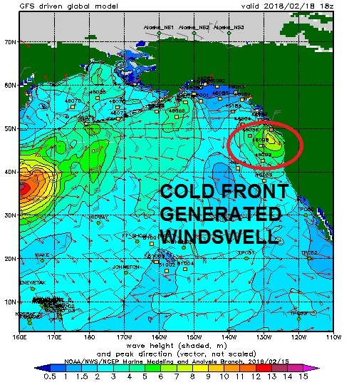
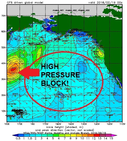
Just a few fleeting showers this week, windy conditions, and mostly NW windswell. Not exactly a stellar winter around here. High pressure has been stunting our Aleutian storm formation so we don’t have any NW groundswells on tap- just more windswell. Today we had bumpy conditions, showers off and on, and small NW windswell.


Tomorrow the NW winds blow stronger as the showers exit the region and we’ll be left with shoulder high NW windswell late in the day and bumpy conditions again.


Saturday cleans up and we’ll have dying chest high NW with a small building SW. For Sunday the NW is waist high while the SW peaks in the waist high range also. Best combo spots will have chest high sets.


Water temps are still high 50’s (until May) and the tides this weekend are 4’ at sunrise, down to 0’ at lunch, and up to 3’ at sunset. Make sure to keep up to date on the waves and weather at Twitter/North County Surf. 

FORECAST:


For Monday, the small SW backs off while new NW windswell builds in the afternoon for chest high sets. Tuesday the NW peaks in the head high range but models show another cold front coming through with rain and windy conditions. Wednesday we have leftover NW and sunnier skies.


Thursday a small SW shows up for waist high waves in the OC while Friday looks small all around.


For next weekend, more NW windswell may arrive while new small SW fills in Saturday. Most spots have chest high sets- but maybe more rain/wind.


After that, forecast charts have been advertising our first solid SW swell hitting our shores around Monday the 5th. If so, we may get head high+ surf and I can finally put away the groveler and break out the step up!!!

WEATHER:


Slight chance of showers as the cold front exits the region on Friday. Look for cold temps again and NW winds in the 20 mph range. Saturday and Sunday look to be nice with sunny skies and temps in the mid-60’s. Models then show a more potent rain maker arriving Monday afternoon through Tuesday. Not looking like a big storm but at least the showers we’ve been experiencing will turn to a more steady rain. After Tuesday, forecast charts get a little hazy. Some models show nice weather mid-week, others show a stray shower. And then for next weekend, models show another storm moving through Southern California. In a nutshell, the only certainty is uncertainty.

BEST BET:
Maybe Sunday with small combo swell and clean conditions or with any luck, that solid SW forecasted for March 5th- if good weather can hold up!

NEWS OF THE WEEK:


From the ‘Just when you think you’ve heard it all’ department comes this: Audio recordings of Hurricanes Irma and Maria's passage over Puerto Rico documented how the calls of coastal critters changed in response to the deadly storms. The hurricanes caused a major disruption in the acoustic activity of snapping shrimp, a reduction in insect and bird sounds, and potentially an intensification of fish choruses, according to new research presented at the Ocean Sciences Meeting Friday.

In March 2017, researchers set up acoustic monitoring sites in coastal forests and coral reefs on Puerto Rico's southwest coast to continuously record the area's ambient sounds. Their goal was to capture the region's land and sea soundscapes -- especially the cacophony of sounds created by animal vocalizations -- and document how and why they change over time.

But the passage of Hurricanes Irma and Maria over Puerto Rico in September gave the researchers an unexpected look at how coastal soundscapes change in response to natural disasters. Although the hurricanes did not directly hit the study area, audio recordings reveal the storms had noticeable short-term effects on fish choruses, snapping shrimp activity in coral reefs, and bird and insect calls on land.

The recordings show fish increased the intensity of their nightly choruses in the days following Hurricane Irma. The clicking of snapping shrimp, which are among the loudest animal noises in the ocean, plummeted during Hurricane Maria, and the daily snapping rhythm was disrupted for several days.

In nearby dry forests, Maria had longer-lasting effects on the soundscape. There was a marked reduction in insect sounds during the three weeks after the storm. Listen to time-lapse recordings of changes to insect sounds, fish choruses and snapping shrimp activity here.

The results show how scientists can use the soundscape as a measure of biodiversity and environmental change, according to the researchers. Capturing responses from a variety of species at the same time can help scientists better understand how the ecosystem is affected as a whole, according to Ben Gottesman, a PhD candidate at Purdue University in West Lafayette, Indiana, and lead author of the new research.

"Sometimes you can't visually assess an impact, but you can certainly capture that through changes in the soundscape," said Felix Martinez, an ecologist and Program Manager at the NOAA National Centers for Coastal Ocean Science in Ann Arbor, Michigan, who will present the new findings Friday at the 2018 Ocean Sciences Meeting, co-sponsored by the Association for the Sciences of Limnology and Oceanography, The Oceanography Society and the American Geophysical Union. "We really need to understand when those changes are natural versus due to some kind of stressor, whether it's human or natural."


Similar to birds and frogs, fish call to find mates and defend spawning territories, producing choruses at specific times of day and specific times of the year. Gottesman suspects one reason the fish may have chorused more after Hurricane Irma -- which coincided with the full moon -- was because the water became very turbid, making it harder for them to be seen by predators.

While the fish increased their activity following Hurricane Irma, shrimp snaps declined steeply during Maria and rebounded in the first few days after the storm. Snapping shrimp make a loud cracking noise with their claws to stun and catch prey. The snapping shrimp recorded in Puerto Rico displayed a very precise¬ schedule of when they snapped the most, almost like clockwork, Gottesman said. After the storms, peaks of snapping activity at dawn and dusk were less pronounced, and it took several days for them to recover to pre-storm levels.

The researchers suspect the shrimp could have snapped less for several reasons. During the storms, the intense current and turbidity likely dissuaded the shrimps from seeking prey, or else the extreme turbidity muffled the high-frequency shrimp snaps. After the storm, Maria may have disturbed their rocky coral habitats, the shrimp could have been spending time cleaning out their burrows, or they may not have been able to see their prey when the water became turbid.

Post-storm recordings show the land and sea animals' vocalizations in this part of Puerto Rico, which was not in the eye of the storm, did eventually rebound to pre-storm levels. Maria was a catastrophic disaster, causing an estimated $90 billion worth of damage, but the new findings show how resilient this coastal ecosystem was in response to the storm, according to the researchers.

So just as you and I get fired up and talk about hurricanes, looks like our animal friends do too.

PIC OF THE WEEK:


As a little kid, I loved the park. Swing set, big soccer fields, picnic benches, dogs running loose. As I get older though, I think my ideal park would look something like this.

Keep Surfing,

Michael W. Glenn
A Whole Lot Of Awesome
Singing the National Anthem At The All Star Game In 2019
Going On Surfari To Find A Rabbit, Da Bull, Condor, Seabass, Owl, Da Cat, Dingo, Flea, Kanga, Dog, Tiger, Goat, and the elusive Wounded Gull

Thursday, February 15, 2018

THE Surf Report- Early Edition


At least the groms are stoked.

SURF:


Another small semi-clean week of surf. Had a little NW show up Monday/Tuesday with a touch of early season SW for chest high sets- but that was about it. Today there was leftover NW/SW for waist high waves. This afternoon the NW wind was blowing and it didn’t do much to build up the surf. For tomorrow, look for waist high+ NW/SW again with clean conditions. Saturday drops slightly but it’s still waist high. Sunday the low clouds return and the surf drops to knee to waist high. All in all some nice weather Friday/Saturday and small waves but not enough to get the adrenaline flowing. 


Water temps are high 50’s and the tides this weekend are 3’ at sunrise, up to 5’ mid-morning, and down to 0’ at sunset. Make sure to keep up to date on the waves and weather at Twitter/North County Surf. 

FORECAST:
Been kind of quiet the past few weeks in the Pacific. I bet it has nothing to do with the fact I bought a step up at the end of January and haven’t ridden it once. I actually had a friend of mine call me out and say I’m the reason for the small surf lately. I think he’s giving me too much credit- I wish I had those kinds of magical powers. I should have bought a groveler instead though and I bet our surf would be 10’ right now. Anyway, where were we? Oh yeah- the small surf. 


We have a cold front coming through on Monday that will whip up our SW winds, drop some light showers, and get the surf back to the head high range by nightfall. If you want to surf and don’t mind a little bump, that’s all Mother Nature has on tap. Tuesday it’s shoulder high with NW winds behind the front. 


We also have a weak storm off Antarctica today that may give the OC some waist high SW next Thursday/Friday and not much for San Diego County. High pressure is still in command in the North Pacific and it’s stunting our swell generation. 


Models show a storm forming off Japan next week that fizzles out before it even gets to Hawaii. With any luck, we may get some waist to chest high WNW from it next weekend. 


And further out, forecast charts show some disorganized storm activity in the southern hemisphere which may give us chest high waves the first few days of March.

WEATHER:


Still no big storms on the horizon but we may have a shower here and there. First up is weak high pressure overhead which will give us great beach weather tomorrow with temps in the mid-70’s and low 70’s on Saturday. We have a small cold front coming down that will kick up the low clouds on Sunday and a chance of showers and windy conditions on Monday. Tuesday is a transition day then high pressure sets up again for great weather again mid-week-  then maybe another shot of showers late Thursday and Friday. Feels more like spring than winter.

BEST BET:
Can’t believe I’m saying this… Best Bet is Monday afternoon with windy, junky, head high storm surf. I guess you gotta take what you can get right now. Ugh.

NEWS OF THE WEEK:


Nice weather we’re having. Almost too nice. As you know, I’ve been talking about our dry La Nina weather pattern since last September and what that means for our lack of rain this winter. As luck would have it, the National Oceanic and Atmospheric Administration is starting to see signs that the La Nina is finally weakening. Hooray! I think. Let’s have a look at the changing atmosphere and what’s in store the next few months:


During January, the sea surface temperature in the eastern tropical (known as the Niño3.4 region- our primary measurement for La Nina/El Nino activity)- was close to 2 degrees cooler than the long-term average. This places it comfortably in La Niña territory.

The November–January temperature in the Niño3.4 region was also 2 degrees cooler than the long-term average. Our second straight year of La Niña’s has been stronger than the first, as the greatest departure from average last year was just 1 degree.  This is somewhat unusual for a consecutive year La Niña, as the second year tends to be a bit weaker than the first.


The atmosphere at this time continues to respond to the cooler-than-average surface waters in the tropical Pacific. Those cooler-than-average waters lead to less rising air and cloud formation in the central Pacific than average (i.e. less of a tropical connection for our storms), with more rising air and bigger storms forming over the far western Pacific and Indonesia.

More evidence during January was provided by stronger-than-average near-surface winds (the trade winds), as well as stronger west-to-east winds in the upper atmosphere. The stronger trade winds help to keep the surface cooler, and to keep warmer water piled up in the far western Pacific—part of the critical feedback processes that make up La Nina/El Nino weather patterns (also known as El Niño-Southern Oscillation or ENSO for short ). However, this feedback doesn’t go on forever, and we’re seeing signs that La Niña’s swan song is imminent.

Scientists also keep track of what’s going on under the surface of the tropical Pacific, as significant temperature changes in the subsurface waters can provide a valuable clue about the evolution of ENSO events. From early December to late January, an area of warmer-than-average water centered between 160–650 feet under the surface traveled from the western Pacific to the east-central Pacific. This underwater wave chased away most of the cooler-than-average subsurface waters, leaving La Niña without it’s steady supply of cooler waters.

This movement toward more neutral subsurface temperatures is one of the factors forecasters are looking at as we anticipate the decline of La Niña. Most of the computer models also foresee this transition, and overall forecasters have come to the consensus of a 55% chance that La Niña conditions will dissipate by the March–May timeframe, as the tropical Pacific transitions to neutral conditions.

While this La Niña’s effect on precipitation and temperature has been generally in-line with expectations over North America, especially regarding the dry conditions across the southern half of the US, global impacts haven’t been entirely as expected during the past few months. Unfortunately, by the time La Nina loosens it’s grip on us, we’ll be head first into spring and our dry summer season again. Bah-humbug.

PIC OF THE WEEK:


Surfed this spot in the far northwest a few years back. Had to park my truck in the bushes, just off an old dirt (i.e. muddy) backroad- so the locals wouldn’t see me- and then hike through the forest 3 miles to get to the surf. Wore my full suit, booties, and gloves on the sweaty hike so I wouldn’t brush up against poison oak. Then put my backpack on the beach and surfed for 4 hours while two bear cubs tore apart my lunch and their 500 pound momma bear kept a watchful eye over me. Dodged an Orca or two then decided to call it a day before the sun set and hypothermia kicked in. That was the least of my worries though. I was chased back to my car by Sasquatch only to find it stolen. Had to hitch hike back the 1,300+ miles home. Luckily got a ride from Large Marge. True story.

Keep Surfing,

Michael W. Glenn
Keeping It Real
2nd On My Fantasy Olympic Team
0.385 Combined Winning Percentage Vs. Richie Rudolph, Noah Budroe, and Kelly Gibson

Thursday, February 8, 2018

THE Surf Report- Early Edition


SURF:

Fun surf the past week as good conditions made even the smallest days a blast. That may change next week but before I get ahead of ourselves, let’s get through the weekend first. 


We had a small SSW fill in today for waist high waves along with small background NW swell. Best spots had inconsistent chest high sets. For tomorrow the NW backs off while the SSW hangs around for waist high+ surf. Saturday both swells are pretty meager. 


On Sunday new small SSW shows up late in the day while new NW windswell/groundswell also picks up. Best spots will be back to chest high again. The condensed version of the story is that it will be small this weekend but not flat. 


Tides this weekend are 5’ at sunrise, down to 0’ after lunch, and back up to 3’ at sunset. And our water temps are still high 50’s. Wear a 4/3 if you got ‘em. Make sure to keep up to date on the waves and weather at Twitter/North County Surf. 

FORECAST:
Still no big storms on the horizon. 


The small SSW from Sunday peaks on Monday for waist high waves again while more NW windswell should arrive on Tuesday for chest high surf. 


After that, models show another weak storm in the Aleutians that could give us chest high sets again from the NW on Thursday. And between all of that… is small background SW swell. Nothing impressive but we’ll have waves. One fly in the ointment is the chance of showers next week (more on that below). So if we do have waves, it may be blown out. As soon as I see big surf on the horizon, you'll be the first to know...


WEATHER:


As mentioned above (twice actually), forecast charts are finally showing showers in the forecast. Not a real storm mind you, but showers. But we’re so in the hole when it comes to rain this season, I shouldn’t be making fun of it. We’ll have great weather this weekend with high pressure in control and temps in the mid-70’s. By Sunday high pressure backs off, the low clouds make a return and Monday afternoon we should see some light showers into Tuesday. Wednesday will be a transition day as another low pressure system heads our way for Thursday/Friday and more showers. All in all we could get ½” of rain. For comparison’s sake, the big storm we had last month dropped 2”+ of rain, so next week’s wet weather is just a drop in the bucket.  

BEST BET:
Pretty much any day the next few days with small surf and clean conditions. More rideable small surf next week too but the showers will put a damper on things.

NEWS OF THE WEEK:


One of the best and worst things about the ocean are rip currents (sometimes incorrectly called rip tides). Let’s have a look:
·         Best:
o   Create sandbars
o   Take you back out to the line-up like a conveyor belt
o   Turn mushy waves into a bowly pocket affectionately called ‘rip bowls’
·         Worst:
o   Rip currents can tear a wave to shreds
o   Losing your board and having to swim against one
o   Waves can lose energy/size if they meet dead on
So just what is a rip current- and why do some people call them rip tides? Well, rip currents are found along most coastlines (whether the ocean or large bodies of water like the Great Lakes) and can be deadly if you’re not prepared. A rip current is a strong, narrow, fast-flowing current directed toward the sea (instead of the beach like the direction of waves) that travels up to 5 mph- which may not seem like much unless you’re trying to swim against it at 3 to 4 mph and getting dragged out to sea. (FYI- Michael Phelp’s top speed is 6 mph so this doesn’t pertain to him I guess. Only Neptune can take him down). Rip currents usually develop close to the shoreline in shallow water (vs. deep water like the middle of the ocean). At it’s core, rip currents happen because of the first law of thermodynamics, also known as Law of Conservation of Energy. This states that energy can neither be created nor destroyed; energy can only be transferred or changed from one form to another. So if a wave breaks towards shore, where is that energy going once the wave has dissipated? Back out to see in the form of a rip current.


For rip currents to form though, there must be areas close to the beach where some waves break (i.e. reefs, sandars, points, etc.) and other areas where they do not (like a channel). As waves enter the shallow water they "shoal" – increase in height – and through their momentum they begin to force water towards the shoreline. Once the waves begin to break – so decrease in height – this momentum is reduced, opposed by another force known as a pressure gradient. This opposing pressure gradient causes the sea surface level to rise up by a few inches where the waves are breaking.

As the surface level of the sea where the waves are breaking over the sandbars is slightly higher than where the waves are not breaking, a current forms from water that is essentially flowing "downhill" from where it is higher to where it is lower. These are called feeder currents, and where they meet between sandbars (i.e. channels) their flow turns away from the shore and becomes the strong rip current that travels through the deeper water.

So why are they dangerous? Rip currents are dangerous because they carry anything in the water seawards to deeper waters, and are not easy for swimmers and surfers to detect. A swimmer in shallow water is likely to drift with the feeder currents along the shore without noticing, at which point they may be carried into the main rip current. Very quickly, they are carried out to sea and out to depths where swimming back to shore may be laborious. At this point swimmers frequently panic, often with tragic results. Those attempting to swim back towards the shore against the rip current will quickly tire as the rip will generally be too strong even for the most competent swimmer (unless your Michael Phelps but I already mentioned that).

A couple simple tricks can be used to spot rip currents before you enter the water. First is to see if there are any channels (i.e. deep water) between waves. A second way is to basically see mini rapids heading out to sea. This is all good and well if the waves are defined with sandbars or reefs as the ‘mini rapids’ will be visible in the deep water channels. But if you’re at a walled beach break, it will be a free-for-all out there with waves breaking all over the place and disguising the rip currents.

Now if you’re stuck in a rip current, the best course of action is to wave your arms like crazy and hope the lifeguard is attractive. Don’t quote me on that. The real best course of action though is to not swim against it and paddle sideways, out of the current, and back towards the safety of shore.


As far as rip tides go, they are also currents but caused by (wait for it- drum roll please)… tides. They are caused by tidal flow in confined areas such as inlets. Two instances that you may know of are the jetties at Ponto in Carlsbad and the harbor entrance at San Francisco. In the case of Ponto, have you ever surfed out there with the tide going from high to low? As the tide drops, the pull of the ocean sucks the water out of the lagoon entrance and a rapid is formed as the water goes out to sea. In the case of San Francisco, it’s Ponto on steroids. There’s a great wave though at the mouth of the bay called Fort Point. A great wave with an incoming tide- not so good on an outgoing tide as you’ll get sucked out to the hazardous north Pacific. This phenomenon though has made quite the sandbar a couple miles out to sea called the Potato Patch. If surfing 50’ waves with great whites and container ships are your thing, have a good read here. 

PIC OF THE WEEK:


If J-Bay is known for it’s freight train rights, what is this wave known as? A runaway locomotive? The little engine that could (break your back)? Bullet train bottom turns? Goin’ off your rails on the crazy train?! I give up.

Keep Surfing,

Michael W. Glenn
Everything is Beknownst To Me
Tabloid Fodder
Editor Of The TransWorld Surfering Journal

Thursday, February 1, 2018

THE Surf Report- Early Edition


No waves, no cry.

SURF:
Sure has been pleasant lately. High pressure has set up shop in the eastern Pacific (again) and stunted our storm growth. Something had to cause this great weather and lack of surf, didn’t it? 


Can’t complain; we’ve had some fun little chest high waves the past few days and great beach weather, but that’s about it. No big surf, no big storms. I doubt it has anything to do with that new surfboard I just bought. This weekend the low clouds/fog return and the surf we had today starts to drop off (don’t shoot the messenger)! Look for chest high sets tomorrow followed by waist high sets Sunday/Monday from the NW/SW combo. 


Water temps are still high 50’s and tides the next few days are 2’ at sunrise, up to 5’ late morning, and down to 0’ at sunset. Make sure to keep up to date on the waves and weather at Twitter/North County Surf. 

FORECAST:


Surf starts to pick up slightly on Monday afternoon for chest high sets thanks to a storm off the Aleutians today. Tuesday that peaks for head high waves (and overhead sets in SD).  Wednesday drops off slightly but still fun shoulder high sets. 


There’s also a small waist high+ S on the charts that will mostly show in the OC on Wednesday (and in SD on Thursday once the NW is completely gone). 


Further out, models show a small chest high NW headed our way around Sunday the 11th


And after that, the southern hemisphere is starting to come to life and we may see shoulder high sets from S around the middle of February. 

WEATHER:


As advertised above, the low clouds/fog return for nights/mornings this weekend and our temps will cool slightly to the mid-60’s (brrrr)! We have a quick/weak cold front passing by to our N on Monday with high pressure setting up shop behind it. What does this all mean? More nice weather for us starting on Tuesday and beyond. As far as our rain chances go- nothing on the horizon. Incredible to think that we’ve only seen 1 storm in the past 11 months and we’re right in the middle of winter too.

BEST BET:
Next Tuesday with good WNW swell and nice conditions.

NEWS OF THE WEEK:


After three consecutive years of record-high temperatures for the globe, Earth was a slightly cooler planet in 2017! But unfortunately, not by much. The National Oceanic and Atmospheric Administration (NOAA) last week came out with their annual climate report and found that Earth’s globally averaged temperature for 2017 was…

…the third warmest year in NOAA’s 138-year climate record, behind 2016 (warmest) and 2015 (second warmest).  Bummer.


The average temperature across the globe in 2017 was 1.51 degrees F above the 20th century average of 57 degrees F. 2017 marks the 41st consecutive year (since 1977) with global land and ocean temperatures at least nominally above the 20th-century average. The six warmest years on record for the planet have all occurred since 2010.

In a separate analysis of global temperature data released at the same time, NASA scientists ranked 2017 as the second warmest year on record. The minor difference in rankings is due to the different methods used by the two agencies to analyze global temperatures; though over the long term, the agencies’ records remain in strong agreement. Both analyses show that the five warmest years on record all have taken place since 2010. Analyses from the United Kingdom Met Office and the World Meteorological Organizationoffsite link also ranked 2017 among the top three warmest years on record.

However, unlike the past two years, Earth’s average temperature in 2017 was not influenced by the warming effect of an El Nino, say scientists from NOAA's National Centers for Environmental Information (NCEI). So unfortunately, we can’t blame El Nino/La Nina like we normally do for our disasters.


Additional findings from the 2017 report:
  • ·         Sea ice extent (coverage) at the poles remained low throughout last year. Antarctica had a record-low extent in 2017, while the Arctic had its second-lowest ice coverage on record.

o   The average Arctic sea ice extent for the year was 4.01 million square miles, the second smallest annual average since record-keeping began in 1979.
o   The average Antarctic sea ice extent for the year was 4.11 million square miles, the smallest annual average since record-keeping began in 1979.
  • ·         Despite the cooling influence of a weak La Nina in the latter part of the year, December ended up as the fourth warmest December on record for the globe, with an average temperature 1.44 degrees F above the 20th century average.
  • ·         The globally averaged sea surface temperature was the third highest on record, 1.21 degrees F above average.
  • ·         The globally averaged land surface temperature was the third highest on record, 2.36 degrees F above average.
  • ·         South America had its second warmest year on record; Asia, its third; Africa, its fourth; Europe, its fifth; and North America and Oceania, their sixth. I guess not being 1st is good for once. Kind of. 

So what does all this warm weather mean? If you ask the soggy Seattle, they’re probably pleased. San Diego on the other hand (where we have more wildfires than you can shake a stick at), not so happy. 

PIC OF THE WEEK:


Great set up- beautiful scenery, big channel to get back outside, long rides, and just you and your bro. Nature’s version of Kelly’s wave pool.

Keep Surfing,

Michael W. Glenn
Adult Prodigy
Chargers Lost To Eagles By 2/Patriots By 8. Patriots Over Eagles By 5

1998 Triple Crown of Skurfing Champion