Friday, January 31, 2014

THE Surf Report


Winter is here! 5 weeks late...

SURF:
Winter is finally here! Not a full blown winter of course, but still, some clouds and a breeze about 10mph from the W overhead. Batten down the hatches!
The past week was firing of course with mild weather and lots of head high+ surf. Today we still have surf from the NW- but the wind has kicked in from a weak cold front. The weak storm also kicked up a short interval NW windswell for more shoulder high waves that peaks tomorrow morning. Saturday morning looks to have shoulder high sets in the AM with bigger sets in SD- but we'll have some more NW winds as the cold front departs. Hey- what do you expect- it's winter finally! Sunday has some leftover waist-chest high waves.
Water temps are 58 and the tides next few days are all over the place- about 5' at sunset, 7' mid-morning, then drops like a rock to -1.5' late in the afternoon. Make sure to keep up to date on the waves/weather at Twitter/North County Surf.

FORECAST:

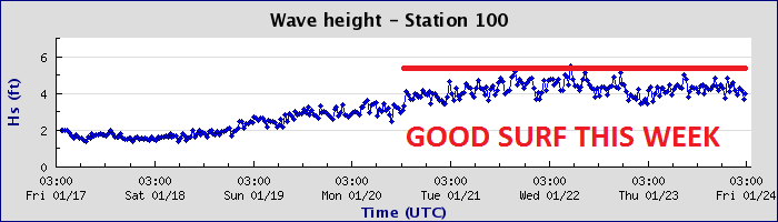
After the slightly junky Saturday and cleaner smaller Sunday, we get more junky surf on Tuesday. Look for more shoulder high sets and breezy conditions again with a chance of showers. That clears out by Wednesday and the surf leaves with it. We do though have another small waist high+ NW windswell on the charts for Thursday. Basically the good weather and firing surf the past few weeks has been replaced by breezy cloudy conditions and average surf. Nothing to write home about.

WEATHER:

Well... winter has finally arrived, but don't expect anything exciting. We have a weak cold front moving through today and we'll get a shot of showers, maybe in the 1/4" range. As a comparison, a normal dousing is about 1/2" and one of those full blown dumpers with wind and everything is about 1". So today's 1/4" isn't much. We get a break over the weekend with sunny skies but air temps only hit the low 60's. Another cold front moves through Sunday evening/Monday morning and models are having a tricky time with this one. We may get another 1/4" of rain like today's weak cold front or something a little stronger in the 1/2" range. Only time will tell- make sure to check back with Twitter/North County Surf. High pressure kicks in towards Tuesday and the weather looks sunny and mild by mid-week.

BEST BET:
Well... there will be a little surf the next few days but the weak cold fronts moving through will mess it up a bit. Saturday morning is probably your best bet even though there may be some wind on it.
 
NEWS OF THE WEEK:

Even though your more likely to get eaten by an alligator than a shark (I'd hate to live in Florida), it still doesn't hide the fact that recent research shows that sharks live longer than we previously thought. Oh joy. Great white sharks -- top predators throughout the world's ocean -- grow much slower and live significantly longer than previously thought, according to a new study led by the Woods Hole Oceanographic Institution (WHOI). In the first successful radiocarbon age validation study for adult white sharks, researchers analyzed vertebrae from four females and four males from the northwestern Atlantic Ocean. Age estimates were up to 73 years old for the largest male and 40 years old for the largest female. "Our results dramatically extend the maximum age and longevity of white sharks compared to earlier studies," said Li Ling Hamady, MIT/WHOI Joint Program student and lead author of the study published in PLOS ONE. "Understanding longevity of the species, growth rate, age at sexual maturity, and differences in growth between males and females are especially important for sustainable management and conservation efforts." Age determination in fish relies primarily on analyzing growth increments in mineralized tissue, such as otoliths (ear bones), vertebrae, and fin rays. These grow throughout a fish's life, adding annual rings, similar to growth rings in trees. Estimating age in white sharks can be challenging. While vertebrae are constructed of layers of tissue, laid down sequentially over an individual's lifetime, the alternating light/dark banding patterns can be narrow and less distinct than in other species, and the bands don't necessarily signify annual growth. "Traditionally, ageing sharks has relied on the assumption that band pairs are annual. In many cases this has been proven correct for part or all of a species life, however in more and more cases this is being disproven," said coauthor Lisa Natanson, a fisheries biologist at NOAA's Northeast Fisheries Science Center (NEFSC) lab in Narragansett, R.I. In previous studies, which assumed annual deposition of growth bands, the oldest white shark individuals identified were from the southwestern Pacific Ocean at 22 years old and the western Indian Ocean at 23 years old. For this study, researchers took advantage of radiocarbon produced by thermonuclear device testing done during the 1950s and 1960s. Radiocarbon mixed from the atmosphere into the ocean, and was incorporated into the tissues of marine organisms living during that time period. The rise in radiocarbon -- measured as 14C -- gave researchers a specific spot in time pinpointed in the vertebra layers, which can be used as a "time stamp" to help determine the age of an animal. The National Ocean Sciences Accelerator Mass Spectrometry Facility at WHOI conducted radiocarbon analysis on collagen in the white shark vertebrae. All of the vertebrae samples came from white sharks caught in the northwestern Atlantic Ocean from 1967 to 2010 that were archived at the NEFSC lab in Narragansett, which has the largest collection of this kind. The samples were also digitally photographed with a camera attached to a stereomicroscope using reflected light for counting growth bands. "This research demonstrates the power of applying cutting-edge techniques in isotope geochemistry to answer fundamental questions in ocean ecology," said co-author Simon Thorrold, a biologist at WHOI and Hamady's Ph.D. advisor. "The radiocarbon time stamp in white shark vertebrae provides irrefutable evidence of white shark longevity that had proved to be impossible to verify using traditional age estimation methods." Researchers found that band pairs are laid down on an annual basis in small to medium-large sized white sharks in the northwestern Atlantic. However, the largest individuals may experience a change in the rate of vertebral material deposition at some point after maturity, or the bands may become so thin that they are unreadable. Assuming a lifespan estimate of 70 years or more, white sharks may be among the longest-lived cartilaginous fishes. While they are predominantly found in temperate and subtropical waters, white sharks migrate long distances and can be found throughout the global ocean. White sharks are considered "vulnerable" worldwide. Since individuals are slow growing, and mature late, white shark populations could be even more sensitive to fishing, environmental and other pressures. "These findings change the way we model white shark populations and must be taken into consideration when formulating future conservation strategies," said co-author Greg Skomal, a WHOI adjunct scientist and MA Marine Fisheries biologist.

BEST OF THE BLOG:

Another Scooby Doo mystery is coming into focus. Just what the heck is being built on the plot of land at the corner of La Costa Ave. and Rancho Santa Fe?! A movie theatre? Another Walmart? A wavepool? (I wish). Check out the latest on the North County Surf blog. Plus the mid-week Surf Check and an in-depth THE Surf Report. All of that and more in the blog below!  

PIC OF THE WEEK:

Considering the horrendous crowds we've had with our recent run of surf, I thought a little empty drainer would get your weekend off to a good start. Yes, there are still empty waves out there- just 5,000 miles away. For more empty shots, check out Todd Glaser's work here.

Keep Surfing,

Michael W. Glenn
Brazen
Representing Bieber
Built for Speed

Thursday, January 30, 2014

North County New Business News: Scooby Doo Mystery


A Scooby Doo Mystery is finally being unraveled. The new shopping center and homes at the corner of Rancho Santa Fe Road and La Costa Ave. are coming to fruition. It's called La Costa Town Square. (Ps- The image above is not of the new shopping center nor are the people/animal depicted in the picture La Costa residents. Just wanted to be up front and get that out of the way).

Construction on buildings have started to sprout up this past week and details are emerging on who the new tenants are. So far we know:
  • Vons
  • Petco
  • 24 Hour Fitness
  • Stein Mart (for those of you that don't know, it's a discount apparel store like Ross but without  the surf brands Hurley, DC, Quiksilver, Billabong, Volcom, O'Neill etc. so I'm not sure what the heck is going to be in there).
  • And other tenants as they get closer to the expected opening in November 2014
  • And definitely NOT a movie theater as the rumor mill was spreading

There will be homes though. Davidson Communities is one of the builders. They are touting "Arterro at La Costa. Nestled in the rolling hills of North County San Diego. Featuring 63 luxury single-family homes. Thoughtful architecture and exceptional detailing will highlight these gracious homes. Residences will feature 3 to 6 bedrooms and offer 3 and 4 car garages. Floor plans range from 3,288 to 4,384 square feet. Pricing from the high 900,000's." (Which means low millions by the time the models go up this summer). The other developer is Taylor Morrison who doesn't have any information available yet on the 32 homes they're building but currently they have 9 developments in the works in Orange County around the $500k to $900k range so I expect it to be the same here.
The official word from Property Development Center's website is: "The proposed La Costa Town Square project entails the construction and operation of a mixed-use center that includes an approximately 267,400 square-foot community shopping center anchored by a new Vons Lifestyle store, 63 luxury single-family detached residential units developed by Davidson Communities and two office buildings totaling approximately 50,000 square feet.

The northern portion of the La Costa Town Square project is a proposed single-family residential project on the north side of Rancho Santa Fe Road, which will include approximately 32 dwelling units. This proposed project is by Taylor Morrison Homes.

The 83.1-acre La Costa Town Square site has been subdivided into four separate parcels:
  • A 41.5-acre commercial parcel with an open-space buffer.
  • A 24.4-acre single-family residential parcel. (Davidson Communities)
  • A 10-acre single-family residential parcel. (Taylor Morrison Homes)
  • A 7.2-acre office parcel
If done right, it should be a nice center that adds value and convenience to the surrounding neighborhoods. Please though, no more Walmarts or Tilly's though.


Tuesday, January 28, 2014

Surf Check


Looks like all the complaining I did in November and December has finally paid off. Great surf the past few weeks along with nice weather has resulted in some great sessions. And crowded as heck line-ups.
Today we have dropping WSW swell (really unique angle for this time of year- usually it's 290-310 degrees from the NW, past few days have been 240-280 degrees which has resulted in some good shape around here). Sets are shoulder high and water temps are holding at 58.
Tides have been pretty mellow the past week- just fluctuating between 1' low tides and 4' high tides. Today it starts to swing pretty wide though with 7' tides at sunrise and -1' tides at 2pm and up to 2' at sunset. Beware the tides! What may look fun when suiting up will change drastically in a couple hours. Case in point- paddling out at 7am you'll see at crazy 7' high tide. When you split at 9am, just two hours later, it's already a medium 4' tide.
As far as our weather goes, no big changes are in store. Just some mellow temps around 70 during the day and low clouds and fog. Models show a couple WEAK cold fronts moving through Thursday night and Sunday night. They MIGHT give us some light showers but nothing important. So our drought continues.
On the surf front, the dropping WSW today is replaced by more NW tomorrow for head high sets and overhead sets in SD. Not too shabby. That lasts into Thursday.
 
As luck would have it, we have a couple more little bumps from the NW this weekend. Nothing big but chest high waves are in store for Friday and shoulder high sets Saturday afternoon. Not as big as the past week but it will be rideable. And if you head to SD, you'll get it about a foot bigger. So get your work done and sneak out for some surf! 

Thursday, January 23, 2014

THE Surf Report- Early Edition


Patience is a virtue.

SURF:

Good surf around here the past few days but that's just an appetizer for this weekend. Did you see the surf report for Kauai yesterday? 35' at 17 seconds. That's big.
The storm that generated that beast had seas around 55' on Tuesday and it's swell is hitting our outer buoys tonight with 25 second readings. So we've got a couple things going on so far- long period WNW groundswell is filling in tonight but tomorrow morning won't be bombing- yet. It will be pretty inconsistent and the buoys are only 7' at 25 seconds tonight. But the swell will fill in rapidly tomorrow and we should have some 10' sets here by sunset with double overhead sets in south SD. By Saturday morning the swell will be peaking with double overhead sets at the best spots in north county SD and triple overhead sets in south SD. Break out the big boards. By Sunday the swell will be winding down but we'll still have overhead sets here and 10'+ sets in south SD. Plan your session wisely and don't do anything foolish! You're not 21 anymore. That sagging mid-section and mortgage proves my point.
Water temps are 58 and the tides next few days are really mellow- about 1.5' at sunrise and up to 3' around sunset. Make sure to keep up to date on the waves/weather at Twitter/North County Surf.

FORECAST:

After the bombs this weekend, we get a little break Monday morning before another NW swell hits late in the day. Not as big as the Saturday swell but we'll still have head high sets here in north county SD on Tuesday morning and overhead sets in south SD. After that mother nature takes a breather. Charts show maybe a little NW windswell later in the week but it's nothing worth noting this early in the game.

WEATHER:

No rain in sight. Just fog tomorrow. High pressure kicks in again this weekend and we get sunny skies and temps in the low 70's. Again. We may have a weak cold front move through Northern California the middle of next week which would kick up our low clouds again but until then, we have great weather for the next 5 days- and most likely not a drop of rain for the ENTIRE month of January. Unbelievable.

BEST BET:
Really, you have to ask? Ok, twist my arm- it's Saturday. But you knew that already. 

NEWS OF THE WEEK:

The National Climatic Data Center recently came out with their annual report for 2013 and there was good news and bad news. Bad news is that we were warmer than normal (what did you expect). Good news is that we were wetter than normal (this was for the entire US mind you- here in sunny Southern California we were dry as a rock of course). Anyway, the contiguous United States (CONUS) average temperature of 52.4°F was 0.3°F above the 20th century average, and tied with 1980 as the 37th warmest year in the 119-year period of record. The 2013 annual temperature marked the coolest year for the nation since 2009. The 2013 CONUS average temperature was 2.9°F cooler than the 2012 average temperature, which was the warmest year on record for the nation. Since 1895, when national temperature records began, the CONUS has observed a long-term temperature increase of about 0.13°F per decade. Precipitation averaged across the CONUS in 2013 was 31.17 inches, 2.03 inches above the 20th century average. This marked the 21st wettest year on record for the nation and the wettest since 2009. Compared to 2012, which was the 18th driest year on record, the CONUS was 4.50 inches wetter in 2013. Over the 119-year period of record, precipitation across the CONUS increased at an average rate of 0.17 inch per decade.

On a statewide and seasonal level, 2013 was a year of precipitation extremes, with temperature extremes being more muted than the previous year. Above-average temperatures during 2013 were observed in parts of the West, Northeast, and in Florida. No state had annual temperatures that ranked among the ten warmest. California tied its 12th warmest year with a statewide average temperature of 60.3°F, 1.4°F above average. Below-average annual temperatures were observed from the Northern Plains, through the Central Plains and Midwest, and into the Southeast. No state had annual temperatures that ranked among the ten coolest. Despite no state having a record warm or cool year, numerous locations across California and Florida had their warmest year on record, while numerous locations across the Plains and Mid-South had their coolest year on record. A map of those stations is available here. Based on NOAA's Residential Energy Demand Temperature Index (REDTI), the contiguous U.S. temperature-related energy demand during 2013 was 7 percent above average and ranked as the 49th lowest in the 1895-2013 period of record. On a local level during 2013, approximately 26,100 daily warm temperature records were tied or broken (10,100 warm daily maximum records and 16,000 warm daily minimum records); while approximately 28,800 daily cool temperature records were tied or broken (16,900 cool daily maximum records and 11,900 cool daily minimum records).

Overall, much of the CONUS was wetter than average for the year, particularly east of the Rockies. The largest precipitation departures from average were observed in the Northern Plains, the Upper Midwest, and the Southeast. In total 10 states had annual precipitation totals that ranked among the ten wettest years on record. Michigan had its wettest year on record with 40.12 inches of precipitation, 8.9 inches above average. This bested the previous record wet year of 1985 by 0.64 inch. North Dakota also had its wettest year on record with 24.54 inches of precipitation, 7.18 inches above average. This bested the previous record wet year of 2010 by 0.29 inch. In contrast, portions of the West were dry. California had its driest calendar year on record with 7.38 inches of precipitation, 15.13 inches below average. This was 2.42 inches below the previous record dry year of 1898. By the end of 2013, 27.6 percent of California was in Severe Drought. To the north, Oregon had its fourth driest year, while Idaho had its 12th driest. Numerous locations across the Southeast, Midwest, Northern Plains, and Rockies experienced their wettest year on record, while locations in California, Idaho, and Washington had their driest. A map of those stations is available here. In term of drought, according to the U.S. Drought Monitor, conditions improved across much of the southeastern and central U.S. during 2013, but deteriorated in the Far West and Northeast. At the end of 2013, about 31.0 percent of the contiguous U.S. was experiencing drought, down from 61.1 percent at the beginning of the year.

Seasonal highlights in 2013 included:

•The CONUS had its 20th warmest winter on record, with much of the eastern U.S. having above-average temperatures. Florida had its tenth warmest winter on record. Below-average temperatures were observed in parts of the West. The CONUS winter precipitation was above average with wetter-than-average conditions along the Gulf Coast and the western Great Lakes, where seven states had a top ten wet winter season. The winter snow cover extent for the CONUS was 15th largest on record.

• Spring temperatures were cool for the CONUS with a temperature 0.5°F below average. This marked the first season since the winter of 2010/11 with below average CONUS temperatures and this was the coldest spring since 1996. Below-average temperatures were widespread in the central and southeastern U.S., where 14 states had spring temperatures ranking among the ten coolest on record. The West and New England were warmer than average. California had its seventh warmest spring on record. Spring precipitation was near-average nationally, with above-average precipitation in the Upper Midwest and below-average precipitation in much of the West. Iowa had its wettest spring on record, in addition to five additional nearby states having a top 10 wet spring. Below-average spring precipitation was observed in the West and Mid-Atlantic. California and New Mexico had a top 10 dry spring.

• The summer CONUS temperature was above average and tied with 1937 as the 15th warmest summer on record. Above-average temperatures were present in the West and Northeast where nine states had one of the 10 warmest summers on record. Below-average temperatures were observed in the Midwest and Southeast. The summer of 2013 was the eighth wettest on record for the CONUS and the wettest since 2004. Record and near-record wet conditions were observed in the East and Southwest. New York, South Carolina, Georgia, and Florida each had their wettest summer on record.

• The CONUS was slightly warmer than average during autumn, with much of the nation having near-average temperatures. The autumn precipitation total was above average. Near-record wet conditions were observed across the High Plains and Northern Plains, where five states were top 10 wet. California had its 10th driest autumn on record.

If you're looking to kill time at the office, read the entire report here.

PIC OF THE WEEK:

Not exactly the most posh yacht for a boat trip, but hey, it's all about the waves, right?

Keep Surfing,

Michael W. Glenn
Anti-Quitter
Made of Money
Bringin' the El Rollo Back!

Tuesday, January 21, 2014

Surf Check


Man was that a doozy today. Solid surf, no wind, some weird high clouds drifting overhead. Seemed surreal. Good news is that more is on the way. But first things first.
Started to see some signs of building W swell back on Saturday then it just kept coming and coming and peaked today with well overhead sets in north county SD and almost double overhead surf in south SD. Look for the swell to go down a notch tomorrow with more head high waves here and overhead sets in SD. Friday looks to be smaller but still fun with shoulder high sets around town.
Water temps are holding at 58 and the tides are pretty mellow the next few days; just 2' at the 7am sunrise, up to 3.5' at lunch, and down to 1' at the 5pm sunset.
As far as our weather goes, high pressure is still in control with temperatures well above normal for this time of year (low 70's at the beaches in January- man we got it good) as high clouds drift overhead. We may get a quick return of fog Wednesday night/Thursday morning but it will be short lived as high pressure strengthens again and we get sunny skies and beach temps in the mid-70's. Just in time for that next solid swell...
So by now you've heard about that big 'monster' storm forming in the Pacific. Well it is a doozy with seas forecasted to peak around 50'. But I'm taking it with a grain of salt since this isn't an El Nino year and the storm will die waaaaay before it gets even close to us. With that said though, we should get some building W swell Friday afternoon and peaking swell Saturday morning with 10' sets here in north county SD and double overhead surf in SD (with best spots going 15'+++). Pretty solid but I don't think it's going to be one of those 25' La Jolla Cove El Nino swells. Would be nice though. Hope I'm wrong.
 
After the big surf over the weekend, the north Pacific takes a little breather and we get some chest high waves towards Tuesday. So you can finally put that step-up away in the closet. 

Friday, January 17, 2014

THE Surf Report


Got the Step-Up ready?

SURF:

Good surf earlier this week and great weather too. Been an odd winter around here. I'd expect a couple fun days like we've had where everything comes togrether but not a whole month. Today is pretty flat but we start to see a little bump tomorrow from the NW. Only SD will really have any little waves but by Sunday we'll see a couple here too.
By Sunday afternoon we should have some fun chest high NW with head high sets in SD.
Water temps are 58 and the tides next few days are about 4.5' at sunrise, almost 6' mid-morning, and down to -0.5' at sunset. Make sure to keep up to date on the waves/weather at Twitter/North County Surf.

FORECAST:
After the slow start to the weekend the Sunday afternoon NW peaks on Monday for head high+ surf in north county and overhead++ waves in SD.

There's not much of a break on Tuesday before a new similar size NW swell fills in Tuesday afternoon. Look for more head high+ waves on Wednesday then a smaller NW fills in behind it on Thursday.
Then models show something I haven't seen in a looooong time. A beast on the charts. The models have also predicted rain a couple times the past month and we know how that went, so take it with a grain of salt. Regardless, if it all comes together, we may get some 10'+ surf around here and double overhead+ waves in SD with bigger sets at the best spots. I should have a good idea on next week's 'Surf Check' so make sure to check back on the blog on Tuesday.

WEATHER:

Now I'm worried. I have no idea on when this good weather will end. Seriously. Nothing on the charts is showing rain in the near future. So expect great weather for another week. There's a weak cold front moving through northern California this weekend so we MAY get some high clouds this weekend and a drop in our temps by a degree or two but that's about it- and maybe the same scenario the middle of next week. So really there's nothing to talk about! We really need rain around here but we're just not going to get it anytime soon.

BEST BET:
As long as this weather holds up- all of next week- with the emphasis being next weekend if that solid swell shows up as expected.

NEWS OF THE WEEK:

I know the water has been cold lately, but not THAT cold. Next time you hear a guy in the line-up say it's 'freezing out here!', you can tell them this:

Ocean water freezes just like freshwater, but at lower temperatures. Fresh water freezes at 0 degrees Celsius (32 degrees Fahrenheit), but seawater freezes at about -1.9 degrees Celsius (28.4 degrees Fahrenheit) because of the salt in it. When seawater freezes, however, the ice contains very little salt because only the water part freezes. It can be melted down to use as drinking water. At least 15 percent of the ocean is covered by sea ice some part of the year. On average, sea ice covers almost about 25 million square kilometers (10 million square miles) of the Earth. Sea water becomes more and more dense as it becomes colder, right down to its freezing point. Fresh water, on the other hand, is most dense while still at 4 degrees Celsius (39.2 degrees Fahrenheit), well above the freezing point. The average temperature of all ocean water is about 3.5 degrees Celsius (38.3 degrees Fahrenheit).

BEST OF THE BLOG:

Did you hear the good news?! The Carlsbad Power Plant is coming down! Stoke! And a new one is going up. Bummer. Get the full scoop on the North County Surf blog as well as a mid week Surf Check and an in-depth THE Surf Report. Right here at the North County Surf blog.

PIC OF THE WEEK:

Sure it looks fast, but that's half the fun of driving through barrels- it's the anticipation if you're going to make it or not.

Keep Surfing,

Michael W. Glenn
Super
Hangin' With Peyton In Omaha
Opening a Surf Resort On Gilligan's Island

Thursday, January 16, 2014

North County News of the Week- Power Brokers

The power plant is coming down! A new one is going up...
 
The San Diego Union Tribune is reporting today that the Carlsbad City Council approved a landmark deal Tuesday that officials said will help solve the region’s energy needs while ridding coastal North County of a notorious eyesore: the 60-year-old Encina Power Station, right smack dab there on the beach at Terramar reef. The agreement allows NRG Energy to replace Encina and its 400-foot cooling tower with a more environmentally-friendly and less conspicuous 90-foot-tall “peaker” plant, and requires NRG to tear Encina down when the new plant opens sometime in 2017.
City officials said the deal, which came together quickly during the last few months, was prompted primarily by the unexpected retirement last June of the San Onofre Nuclear Generating Station, which had supplied much of the region’s power. The closure of San Onofre boosted San Diego Gas & Electric’s interest in buying power from a new plant in Carlsbad. The public utility, which also signed off on Tuesday’s agreement, had previously balked at proposals for new gas-powered plants on the Encina site. Carlsbad officials and local environmental groups had also fought hard against a new plant near the coast, lobbying for the site to be cleared for recreational and commercial uses once the Encina plant shuts down. Carlsbad City Councilman Mark Packard said Tuesday that city leaders shifted gears this winter after realizing it was inevitable that Carlsbad would have some sort of power plant after Encina closes. In 2012, the city unsuccessfully appealed the California Energy Commission’s approval of a larger NRG project than the peaker plant, and lost again when it took that fight to the state Supreme Court last year. “This was the best compromise that could be reached for all sides,” Packard said. “A new power plant was going to be built on the Carlsbad site.” Councilwoman Lorraine Wood agreed. “It’s a win, win, win situation,” she said. Officials from NRG and SDG&E offered similar sentiments.
Hopefully the new plant located on the freeway- about 1/4 mile from the old power plant on the beach, will blend in with the surroundings- kind of like the Solar Turbines operation at Lindbergh Field.  Jim Avery, senior vice president of supply for SDG&E, praised all three parties for “incredibly fast” negotiations and for striking a deal that will help supply the region with much-needed power. He said the utility shifted its position because of San Onofre.  “The biggest obstacle we ran into was San Onofre being decommissioned at least 10 years earlier than expected,” he said. John Chillemi, NRG’s west region president, outlined all the benefits of the deal for the city on Tuesday night during a long slide show presentation. In addition to aesthetics, they include less pollution, less noise and an end to the use of ocean water in the process of generating power. The new plant will instead use reclaimed sewer water for cooling.
The city will get 60 acres of land from the Encina site. The agreement also includes relocating SDG&E’s North Coast Service Center on Cannon Road within the next decade, freeing up another 16 acres that will be turned over to the city. That part of the deal hinges on an alternate site being found, but Carlsbad gets $10 million in damages if the service center stays where it is. And if Encina continues operating into 2018, NRG must pay the city “liquidated damages” between $3.6 million and $12 million per year, depending on the amount of power generated. NRG would pay for the relocation of the service center and the teardown of Encina, with no cost to ratepayers, city officials said. The council, which approved the deal 3-0 with Mayor Matt Hall and Councilwoman Farrah Douglas absent, was warned by city officials that rejecting it could revive the larger plant NRG had wanted before. Assistant City Manager Gary T. Barberio said NRG would probably have tried to negotiate a deal to sell power from that plant to Southern California Edison if Carlsbad had balked. On Tuesday, the council was also encouraged to approve the pact by the Carlsbad Chamber of Commerce, labor unions whose workers would build the plant and the Agua Hedionda Lagoon Foundation. Two residents and the Sierra Club opposed the agreement, urging the city to hold out for its longtime goal of having no power plant on the site. “This is a much-improved option, but it’s still a power plant on the coastline,” said Terramar resident Kerry Siekmann. “Our coast is a precious jewel.” In response, council members said the agreement would free up many acres of coastline for recreational and commercial uses.
What I could never understand though is why that big ugly box never had a beautification project for it? Like um, landscaping around it to soften it. Or maybe in the 80's getting Wyland to PAINT SOME FRIGGIN' WHALES AND DOLPHINS ON IT. Is it just me or was that the biggest no brainer of all time? Anyway, at least the old one is coming down and hopefully the new space on the coast will be put to good use.