Thursday, January 26, 2023

THE Surf Report


Welcome To Octobuary!

SURF:


Classic fall conditions today- combo swell, offshore winds, sunny skies, and temps in the low 70's at the beaches. Could have sworn it was October around here- except the water temps in the high 50's reminded me it was late January instead. For Friday, the SW will hang around while the 'Eddie swell fades. Look for more chest high sets most everywhere. 


On Saturday, the SW fades while new NW fills in for more chest high surf. The same storm that is giving us surf on Saturday, is also giving us showers late Sunday. Look for a slight uptick in surf on Sunday for shoulder high sets- but most likely SW winds. And here are tides, sunrise/sunset, and water temps for the next few days:
  • Sunrise and sunset:
    •  6:46 AM sunrise
    •  5:18 PM sunset 
  • Water temps are now 57 degrees due to the N and NE winds the past few days. 
  • And tides have evened out this weekend:
    • about 3' at sunrise
    • 1' mid-morning
    • and 2.5' late afternoon
FORECAST:


Forecast calls for showers on Monday- so we'll most likely have W or NW winds that will make a mess of the weekend's leftover NW swell. 


Tuesday is a transition day as the weather and surf tries to clean up with more chest high surf and a new small SW arrives. Wednesday has more chest high sets in far N County SD and the OC from the SW, then the rest of the week should have nice weather and smaller waist high surf from the NW. 


Nothing big on the horizon but we may bet more chest high+ NW next Sunday. So until then, enjoy THIS weekend. 

WEATHER:


Offshore 'Santa Ana' winds will back off tonight and we may see a return of patchy fog by Friday evening as the next Pacific cold front heads our way. Saturday looks to be mostly cloudy and cooler then our next shot of showers arrives Sunday afternoon. Nothing big like our storms the past few weeks but there is a chance of 1/2" of rain by Monday. That departs by Tuesday then the 2nd half of next week should be sunny and mild. Here's a quick summary of the week ahead:
  • Patchy fog late on Friday and temps in the mid-60's
  • Saturday has a few more clouds and temps in the low 60's
  • Showers by noon on Sunday and temps only in the mid-50's! 
  • More of the same on Monday and breezy
  • Transition day Tuesday and things dry out and cool temps again
  • Then we're back to low 60's and sunny skies the 2nd half of next week.
If anything changes between now and then, make sure to follow North County Surf on Twitter!

BEST BET:

Friday/Saturday with leftover SW/NW and clean conditions. 

NEWS OF THE WEEK:


California is known for some of the best and user friendly surf on the planet. Sure the crowds are ridiculous, but if you want to push your surfing, let me introduce you to Lowers, Blacks, Malibu, Rincon, and Swamis. But if you REALLY want to push your surfing, you're looking for something a little less crowded, and fear is not a word in your vocabulary, I've got some spots for just a handful of people. THE Surf Report will be doing a 5 part series on the sketchiest waves in the Golden State, starting with #5 this week... Ghost Tree. Take into consideration the large boulders in the take off zone, the sharks, the fog, the wind, the kelp (which will snag your fins or even worse- hold you under after a wipe out), AND the loss of life, Ghost Tree should be higher up on this list. Regardless, Surfertoday.com did a great write up on the spot recently. Here's what they had to say: 


It was once hailed as the next big thing in extreme surfing until a series of events and federal decisions kept riders out of the water. Ghost Tree is a surf break located in Pebble Beach, California, just outside the 18th hole of Pebble Beach Golf Links in the Monterey Peninsula.

The name of the spot was given by local surfers. It derives from the white and gnarly local cypress trees in the area and, in particular, from a spooky tree where the ghostly figure of a former land owner, Dona Maria - "The Lady in Lace" - has been spotted on dark foggy nights. The truth is that Ghost Tree's mythical aura resulted in tragic consequences and became one of the few waves in the world to claim a surfer's life. The pioneers of big wave surfing in this Central California right-hand avalanche never approved its mainstream nickname. They prefer to call it Pescadero Point.


The story of Ghost Tree goes back to the early 1960s when Fred Van Dyke adventured himself into Ghost Tree and bodysurfed it. In the following decades, surfers explored the surroundings, studied the optimal riding conditions, and gave it a go. However, most of them felt the wave was too fast and broke too close to the Monterey Peninsula's coastal rocky formations.

Everything changed in the 2000s with the advent of motorized personal watercraft (PwC) and tow surfing - surfers could catch any wave they wanted while backed up by water safety teams. "I watch golf, and the Pebble Beach Pro-Am goes on all the time, and it's right along the ocean," recalls big wave surfer Peter Mel. "As a surfer, anytime you see a wave, you're like, 'Is that a wave?' So I remember distinctly watching it. "It was a nice beautiful day, there was some swell running, and I saw these rights peeling off the point in the background." "Sure enough, in one of our first times there, we got to tow it for the first time."


Mel was not alone at Ghost Tree. He was with Adam Repogle. "We did learn a lot in that first session. I'm glad we didn't show up on a day when it was really doing it because we wouldn't have had any idea what to expect," notes Repogle. "It was definitely pumping, but it was small in relation to what was to come." "After the word got out that Peter and I had surfed it, many guys from down there said it had been surfed before - guys have paddled into that wave."

At the time, everyone knew that on the biggest days, there was no way people were going to paddle in. And so it became a tow-in 50-foot-plus cult wave. The big wave surfing community had a new sanctuary in the heart of the California coast. For three years - 2005, 2006, and 2007 - powerful west groundswells blessed Pescadero Point with humungous waves. On December 4, 2007, the surf break claimed a human life during a long-period XXL swell.


"I tried jumping off the rocks off the back side, and I grabbed this kind of tree and slid down the cliff, but it broke, fell, and I crashed," explains Anthony Tashnick. "I got washed on the rocks, blown out, and paddled out around." "Then, I saw Peter Davi. I went up and asked him where I should sit and if it was cool to paddle there. And he was like, 'Oh, yeah!'" "He pulled a tow board and gave me the best introduction to the whole area. He was so passionate. He said, 'It's not called Ghost Tree! It's called Pescadero Point!'" "He told me how much the area meant to him and basically guided me into a wave. I got one wave, I was on my feet in the air, and it felt forever." "I got bounced off, got pounded, and then washed up. I ran to my car, and that was the last time I saw Pete." Longtime local Peter Davi (1962-2007) had drowned at his dear Pescadero Point.

The tragic episode triggered a cold war between the surfing community and the National Oceanic and Atmospheric Administration (NOAA). NOAA is the federal agency that manages American marine sanctuaries. The problem was that PwCs were a threat to the protection of wildlife. They were launching at Monterey Harbor, traveling 11 miles around the Monterey Peninsula and through six protected marine areas before getting to the infamous surf break. Ultimately, NOAA decided that big wave surfing at Ghost Tree and environmental protection were incompatible. An exception - with specific rules - took effect 100 miles north at Half Moon Bay's Mavericks in March 2009. In December, January, and February, surfers could get tow-in assist and jet ski rescue when a high surf warning was in effect. As a result, the focus and attention shifted from Central to Northern California, and Mavericks regained the status of a cult wave.


The good thing about the jet ski regulation was that a growing number of surfers started returning to the sport's essence and replacing motor with arm power. In reality, there were new grounds to be conquered and new heights to be climbed by taking paddle-in to taller and taller waves. Rather quickly, Mavericks took over the big wave surfing scene in California, and Ghost Tree succumbed to its raw nature and fell off the map. "If you were to charge a place like that on the biggest days, you'd be doing it solely on your own, concluded Mel. "So anybody charging it big now is taking a huge risk. We don't have the safety mechanisms you have at other places in the world." The myth of Pescadero Point is still alive, though. The wave is still there, rising in the sky as vibrant and exuberant as ever in green, kelp-infested waters and waiting for the paddle-in heroes of tomorrow.
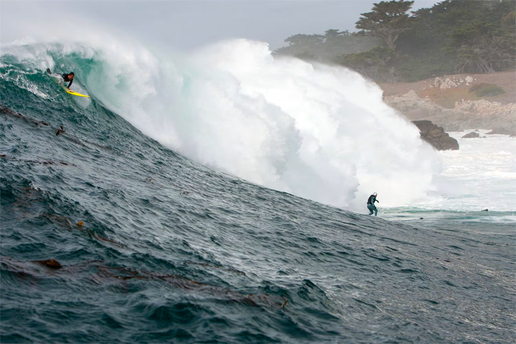
PIC OF THE WEEK:


From afar, it almost looks peaceful. Nice big channel to paddle out in, lack of a crowd, sunny skies, and darn good shape. AND... the legendary Pebble Beach Golf Course sits on the point. But we all know better, don't we?

Keep Surfing, 
Michael W. Glenn
Boundless Energy
Earth's Inner Core Stopped. My Bad. 
THE Suf Report Is Now Beeing Writen By ChatGPT

Thursday, January 19, 2023

THE Surf Report


Is It Over Yet?

SURF:


Sorry, I've been hiding under my bed the past few weeks. The big storms and even bigger surf had me a bit spooked (along with a few sewage spills up and down the coast). Looks like we're back to a normal San Diego winter around here- smaller surf and sunnier skies. 


For tomorrow and the weekend, we have a weak cold front moving by to our N tonight which will send a small but fun NW wind/groundswell our way for Friday. Look for chest high surf in N County SD and shoulder high surf in southern SD. On Saturday, surf drops even further to the waist high+ range (had to believe, I know) but the weather will be nice with a slight Santa Ana condition. For Sunday, we get another NW wind/groundswell for chest high surf (bigger in SD) and nice weather again. Tides, sunrise/sunset, and water temps for the next few days:
  • Sunrise and sunset:
    •  6:48 AM sunrise (6:30 AM paddle out?)
    •  5:13 PM sunset (5:30 PM paddle in)?
  • Water temps are still high 50's and suspect quality due to the sewage spills. Hopefully everything is cleaner by the weekend. 
  • And tides are REALLY extreme this weekend. A 9' swing!:
    • about 6' at sunrise
    • almost 7' around 8:30 AM
    • drops like a rock to almost -2' at 3:30 PM
    • and back to 0' at sunset
FORECAST:

The building NW on Sunday peaks Monday for more chest high surf in N County SD and shoulder high surf in southern SD. We also have more mild Santa Ana conditions. High pressure is still in charge but models show a solid storm forming above Hawaii this weekend then getting pushed in British Columbia.


Luckily for us, that will result in long period NW groundswell filling in for head high surf in N County SD and overhead+ sets in southern SD by Wednesday. Models also show a slightly stronger Santa Ana condition so it could be pretty darn good around here mid-week (i.e. Emergency Boardriding System activation). 


The southern hemisphere is also trying to get its act together with a small SW  headed our way mid-week. The OC will most likely see waist high+ surf from it while the larger NW will overrun it in SD. 


Thursday drops but is still fun for chest high sets, then we may see a smaller but still good shoulder high NW groundswell by late Saturday. In summary- nothing like it was the past few weeks- but at least it's cleaner and fun. 

WEATHER:


A weak cold front is passing by to the N tonight with a last shot of showers for us- and then high pressure takes control for the foreseeable future. According to the models, looks like the rain will be done through the end of January. Look for on again, off again Santa Ana conditions for next week and warming temperatures. Here's a quick summary of the week ahead:
  • Clearing cool skies on Friday and temps near the high 50's
  • Saturday sunny and nice and low 60's with a slight Santa Ana condition
  • More of the same on Sunday
  • More of the same on Monday
  • More of the same on Tuesday but maybe stronger Santa Anas
  • Ditto for Wednesday
  • Late in the week- more sunny skies and temps in the mid-60's!
If anything changes between now and then, make sure to follow North County Surf on Twitter!

BEST BET:

I'm thinking Tuesday/Wednesday with mild Santa Ana conditions, a good NW groundswell, and a smaller SW for the heck of it. EBS will be on standby...

NEWS OF THE WEEK:


Now that we have a break in the action, let's take a look at our rain totals and what to expect long term. For our totals, we have:
  • Los Angeles: 10.73" (203% of normal). Last year at this time? 8.79". And we're aiming for 12.23" by the end of September. 
  • Newport Beach: 8.25" (167% of normal). Last year at this time? 5.64". And we're aiming for 11.18" by the end of September.
  • Oceanside: 9.49" (192% of normal). Last year at this time? 5.47". And we're aiming for 11.86" by the end of September. 
  • San Diego: 7.37" (176% of normal). Last year at this time? 3.75". And we're aiming for 9.79" by the end of September. 
The back to back storms last weekend gave us roughly 4" of much needed rain along the coast and about 24" of snow in the San Bernardino mountains. That was a lifesaver. Models show us staying high and dry until the end of the month- then with some hope- showers may return in early February. 

And in the long long long term, will we see El Nino return next winter? As you know, we've had 3 straight years of La Nina which NORMALLY result in below average rainfall. So El Nino of course may flip that with above average rainfall and the storm track aimed more towards Southern California (as well as warm summer waters and an increase in hurricane activity off Baja). Here's the latest from the National Oceanic and Atmospheric Administration:

The sea surface in the tropical Pacific has been cooler than the long-term average (1991–2020, currently) since mid-2020, and it remains so (thanks for nuthin' La Nina). However, we did see some weakening of this pattern over the past few weeks.

What we did not see weaken though was the La NiƱa-like atmospheric pattern over the tropical Pacific. The atmosphere typically responds to La NiƱa’s cooler-than-average sea surface with a stronger-than-average Walker circulation: more rain and clouds over Indonesia than average, less over the central tropical Pacific, and stronger winds, both the near-surface, east-to-west winds, and the upper-level, west-to-east winds. In December, all these patterns were still clearly present.

We also regularly take the temperature of the subsurface tropical Pacific, as the water at depth can supply the surface. There’s been a substantial amount of cooler-than-average water under the surface since late summer, but this weakened a lot over November­–December. However, the subsurface in the eastern Pacific is still relatively cool. So La NiƱa is still in force, then. What’s to come, you ask?


Let’s get right to the punchline: there’s an 82% chance that La NiƱa will have ended and neutral conditions will reign by springtime (March–May). Forecasting the exact season (any three-month average is a ‘season’ in the ENSO-monitoring world) that La NiƱa will end (January–March? February–April?) is always challenging, since the range of potential outcomes shown in the forecast models is still substantial even just a couple months ahead. Our dynamical computer models, computer programs that use complex mathematical equations to predict how current conditions will evolve in the future, are leaning toward an earlier transition. However, the statistical models, which make predictions based on how similar conditions from past years evolved, are thinking neutral conditions will arrive a little later. The forecast team is favoring the statistical models’ outlook, in part due to that strong La NiƱa-like atmospheric circulation mentioned above.

So is El NiƱo in store for next fall/winter??? We need to see more signs of El NiƱo before we would start expecting that. It’s still more than 6 months away, and the probabilities for neutral+La NiƱa are still pretty close to even with El NiƱo. Also, since ENSO is a seasonal pattern, we need to be able to expect that El NiƱo’s characteristic warmer-than-average tropical Pacific would be present for more than one or two months in a row. We don’t have strong physical signs right now, either, like a large amount of warmer-than-average water looming under the surface, and the Walker circulation is still amped up. Stay tuned, for sure—but for the moment, we are not issuing an El NiƱo Watch.

One more thing to mention- California got deluged with rain and snow tis month with a series of atmospheric rivers. You may be saying “hey wait, I thought La NiƱa meant California and the southwest would be dry this winter!” It’s true, typical La NiƱa impacts include a drier-than-average southwestern U.S. and more rain and snow than average in the Pacific northwest. But ENSO only makes certain seasonal impacts more or less likely—it’s not a guarantee of a drier/colder/warmer/wetter winter. If it were a guarantee, it would make our jobs a lot easier! In fact, we have a fairly recent example of another winter that deviated from expected La NiƱa impacts, 2016–17.

Also, it’s currently impossible to predict short-term weather patterns months in advance. Right now, we can only say that La NiƱa winters tend to be drier across the southern U.S. Maybe in time we’ll have the capability to predict this type of subseasonal variability months in advance. You can bet there will be a lot of research into understanding the weather and climate drivers behind this extreme rain/snow pattern and if/how climate change factors in.

BEST OF THE BLOG:


Just a reminder that the upcoming North County Board Meeting is TOMORROW, Friday the 20th. And we'll be meeting at Broad Street Dough Co. in the Encinitas Lumberyard. Note the new time too: 8-9 AM for all of you sleepyheads. If you haven't been to Broad Street yet, it's a great group of people who make great donuts. Come on down to support your community and talk a little surf while you're at it. Thanks for the support and we'll see you tomorrow morning!

PIC OF THE WEEK:


That left off the point looks FIRING. But... those weird clouds floating above the lineup gives it a creepy vibe. Like Kong is lurking in the forest. Ha! He's not real, right?... You paddle out first. I insist.

Keep Surfing, 
Michael W. Glenn
High-caliber
Golden Globe Nominee
Snapped My 9'0" Gun At Todos. But On A Positive Note- I Have Two 4'6" Grovellers Now!

Thursday, January 12, 2023

THE Surf Report


I've run out of superlatives. 

SURF:

Let's just cut to the chase: That was some bombing surf last Friday. Want to know the scary thing? That swell actually peaked in the middle of the night on Thursday when we were asleep! 


Could you imagine adding a few more feet to that swell? No thank you. Not that I was afraid or anything. I would've had paddled out. Guess we'll have to wait until next time... which happens to be tomorrow. Gulp. Buoys in Nor Cal today were seeing 25 second readings from a looooong period large WNW swell and most spots in Central Cal this evening are seeing 22 second readings. 


That swell will start to fill in overnight here in So Cal with overhead sets by dawn. As the day progresses, the long period swell will filter in more to SD with 12-15' surf at best spots while N County SD looks to have 10' sets and 8' sets at best OC spots. That will last into Saturday. Sunday drops to more 'manageable' overhead surf. But beware! Rain should return (heavy at times) by Saturday- along with messy conditions- that could last into Sunday morning. Tides, sunrise/sunset, and water temps for the next few days:
  • Sunrise and sunset:
    •  6:51 AM sunrise 
    •  5:05 PM sunset 
  • Water temps are still high 50's and suspect quality returns Sunday due to the new rain runoff.
  • And tides are WAAAY more mellow this weekend:
    • about 3' at sunrise
    • 2' mid-morning
    • back up to 3' mid afternoon
    • and back to down to 2' by sunset
FORECAST:


And on to the next storm. The surf starts to pick up again on Monday as low pressure makes it way into Southern California. By Tuesday- it's back to double overhead WNW jumbled surf as the cold front exits the region. Wednesday should be cleaner (the weather that is- not the water quality) and the surf should back down to the overhead range. Long range charts show high pressure FINALLY taking control for good weather, but that also means our swell generators will get pushed up into the Aleutians. 


By next weekend, models show a new NW groundswell hitting SD with head high surf and clean conditions. Looks like our rain and relentless big swells may be done for the time being.

WEATHER:


Today was quite pleasant if I don't say so myself. Sunny skies, temps in the high 60's, and no real wind to mess up the surf. Friday looks to be about the same before storm #38 this winter (or at least it seems like that) hits our region. Sunday is a transition day, then more rain for Monday/Tuesday. Models though show us drying out for the foreseeable future by late in the week. So maybe our rain is over? Here's a quick summary of the week ahead:
  • Friday nice
  • Rain by Saturday afternoon- and breezy
  • Transition day Sunday
  • More rain Monday! (and breezy)
  • Transition day Tuesday
  • Nice from Wednesday until... forever?
If anything changes between now and then, make sure to follow North County Surf on Twitter!

BEST BET:

Friday before the rain returns this weekend. Definitely an Emergency Boardriding System activation day. Or wait until late next week when all storms shift to the N and we're left with smaller, cleaner surf by Thursday into next weekend. 

NEWS OF THE WEEK:


Either we've been in a wave/weather drought for so long that I don't remember what it's like to see downpours & double overhead waves, or we really are experiencing a special time as surfers right now. 

As far as the rain goes, how are we doing in regards to seasonal averages and our we out of our drought yet? Let's take a look at our current rain totals first:
  • Los Angeles: 8.28" (178% of normal). Last year at this time? 8.70"!
  • Newport Beach: 6.33" (145% of normal). Last year at this time? 5.58"
  • Oceanside: 5.95" (135% of normal). Last year at this time? 5.27"
  • San Diego: 4.57" (123% of normal). Last year at this time? 3.59"
As a rule of thumb, we need around 10" here in Southern California by season's end (September 30th). Sounds good, right? About 8 1/2 months to get another 2-6" or so for most locations? Well... the bulk of our rain falls between December and March, so we've got roughly 10 more weeks. On the 'glass is half full' outlook, we're right on track. On the 'glass is half empty' outlook, we are in a La Nina pattern and this could shut off any time- like it did last year. 


But the real story is, how are those reservoirs looking? Luckily, some of our biggest reservoirs are in Northern California which has been hit hardest from these storms. Here's some data from the San Francisco Chronicle:

Statewide reservoir storage, which has declined significantly over the past three years thanks to drought and diminished snowpack, is now up to 84% of average as of midnight on Jan. 10, according to the state Department of Water Resources. Just five days ago, average storage levels were at only 78%, and one month ago, were 68%.

While nearly all of the state’s largest reservoirs remain below their historical average for this time of year, the series of storms continue to push water levels up, even compared with just last week. Lake Shasta, which is the state’s largest reservoir by volume, rose from 35% to 42% of its total 4.5 million-acre-foot capacity over the last five days — both up from 31% a month ago. The additions bring the reservoir to 70% of its historic average for this time of year.

Lake Oroville similarly jumped up from 41% five days ago to 47% as of Jan. 10, bringing it to 88% of its historic average. And one major reservoir — Don Pedro, located in the Sierra Nevada foothills east of Modesto — hit 100% of its historic average water storage this week, which is 69% of its total capacity of 2 million acre-feet. Five days ago, it was at 92% of its average. While some smaller reservoirs have even surpassed their historic average after the rains this month, all are still below their total capacity.

While the precipitation is a positive, water experts stress that even a few weeks of consecutive storms aren’t enough to reverse several years of drought. While the rains have improved drought conditions across the state, according to the most recent U.S. Drought Monitor update last Thursday, the entire state remains at least abnormally dry, with much of it falling into the severe or extreme drought categories — the third and fourth worst categories out of five.

Jeanine Jones, drought manager for the California Department of Water Resources, told The Chronicle last week that only sustained precipitation through the season would be able to make a meaningful improvement in the state’s water supply. “It's great that we're having some storms and getting (precipitation), but we need that to continue,” she said.

BEST OF THE BLOG:


Just a reminder that the upcoming North County Board Meeting is NEXT Friday the 20th. And until the waves & weather clean up, we'll be meeting at Broad Street Dough Co. in the Encinitas Lumberyard. Note the new time too: 8-9 AM for all of you sleepyheads. If you haven't been to Broad Street yet, it's a great group of people who make great donuts. Come on down to support your community and talk a little surf while you're at it. Thanks for the support and we'll see you on the 20th!

PIC OF THE WEEK:


During all the chaos up and down the California coast the past week, there were some gems to be had if you looked hard enough. Like this good left reefbreak, right in the middle of about 1 million surfers. Seriously. Happy hunting! 

Keep Surfing, 
Michael W. Glenn
Effulgent
About 68% Sure I Don't Have Any Classified Docs
Sponsored By Olive Garden Because My Arms Felt Like Wet Noodles This Week

Thursday, January 5, 2023

THE Surf Report


It's alive, IT'S ALIVE!

SURF:
So yes, I'm a wave & weather nerd (I think the actual scientific term is 'Meteorological Moron'), but are you not excited?! I'm not a big fan of 1-2' surf and June Gloom as you know, so this is kind of a big deal for me. The Pacific hasn't been this active, since, well, I don't know, but I do know this- it's not letting up any time soon. 

Solid surf this past week has led to a BOMBING swell along the California coast this evening. If you didn't have a chance to watch it from afar this afternoon, you'll have a slight chance Friday morning as the swell starts to subside. The good news is that the swell is too big to surf anyway (unless your name is Lance Burkhart) so we'll be back to the head high range for Saturday. 


Sunday gets a slight reinforcement from the WNW for more head high+ surf (and bigger in SD)- with another chance of showers and suspect winds. Be careful out there this weekend! Tide, sunrise/sunset, and water temps for the next few days:
  • Sunrise and sunset:
    •  6:52 AM sunrise 
    •  4:59 PM sunset (THIS close to 5 PM!)
  • Water temps are still high 50's and suspect quality due to all the rain.
  • And tides are going to make a mess of the coastline tomorrow with the leftover big surf:
    • almost 4' at sunrise
    • almost 6' mid-morning
    • and about -0.7' late in the day
FORECAST:

Another tricky forecast ahead of us as the storm door remains open and the arrival of various storms next week complicate the timing. 


At this point, it looks like another solid WNW swell should arrive by Tuesday for 10' surf in N County SD and double overhead sets in SD. It won't be as big as tonight's swell but still plenty of size for you chargers. 

Things calm down by Thursday then ANOTHER well overhead swell could arrive by Friday. Rain looks to be in the mix as well, so finding a clean window to surf- and a beach that can hold the swells- will be key. So the Emergency Boardriding System is staying on for the foreseeable future. 

WEATHER:


With all this rain, you'd think we'd be well above average for our rainfall this year and out of our drought. But of course we're not! If you remember last year, we also started off with a bang (a couple big storms vs. our steady stream of storms this year)- and then it went quiet after that. Currently we're sitting at about 5" of rain (about 130% of normal) with more rain due next week, so no complaints there. As far as our drought goes, we've been below average for over 20 years, so the current rain is just a drop in the bucket. Reservoirs are still historically low but on a positive note, our wildfire threat has subsided for the time being. For the upcoming week, here's a rough estimate of what's in store...
  • Friday/Saturday dry and cool
  • weak cold front for Sunday
  • better chance of rain for late Monday/early Tuesday
  • Wednesday/Thursday dry and cool
  • more rain by Friday?...
If anything changes between now and then, make sure to follow North County Surf on Twitter!

BEST BET:

Tough to say due to the multiple storms lined up over the ocean like planes coming into LAX (I just cut and pasted that from last week if you noticed). Even though Saturday and Thursday will be smaller, at least the weather will be cleaner. Or Tuesday/Friday for all you storm surf people out there. 

NEWS OF THE WEEK:


Thanks to the 1975 summer blockbuster 'Jaws', it's been falsely believed that great whites are blood thirsty predators. In reality, like most sharks, attacks are a mistake and most them don't 'finish the job'. After inadvertently biting a human, they leave the area realizing it wasn't the seal they were looking for. If you look at the amount of sharks in the ocean (estimated at 1 billion) and the amount of surfers in the world (estimated at 50 million), sharks could be nipping at us all day long if they wanted to. But they don't. So who does that leave as the apex predator in our oceans? If recent video footage suggests, orcas take the title. Here's what Smithsonian Magazine had to say:

For several years, scientists have suspected that orcas have been killing and eating parts of great white sharks off the coast of South Africa. Now, they have the video evidence to prove it. Drone and helicopter footage captured in May shows orcas, also called killer whales, attacking and killing at least two great whites off Mossel Bay in South Africa’s Western Cape province, writes the Washington Post's Rachel Pannett.

A video clip of the predation was released in the summer, but scientists shared more extensive footage with a new paper published last week in the journal Ecology, according to a press release.

“It’s probably one of the most beautiful pieces of natural history ever filmed,” Alison Towner, a great white shark biologist at the Marine Dynamics Academy in South Africa and the lead author of the paper, said to the Daily Beast’s Kevin Fallon in July.
Killer “whales,” which are actually dolphins, are apex predators, and their diet includes fish, squid, seals, sea birds and whales larger than themselves, according to the Natural History Museum in London. They are the only known predators of great white sharks.

Since 2017, eight attacked great whites have washed up on the shores of South Africa, according to Gizmodo’s Isaac Schultz. The sharks were missing hearts and livers—evidence that they had been killed by orcas. The number of great whites in the water off South Africa’s coast has also been declining in recent years, possibly due to orca predation, per the Post.

But scientists had never observed this behavior in detail—until now. The drone footage shows a group of five whales pursuing sharks for more than an hour, according to the Agence France-Presse (AFP). In one clip, two orcas swim near a shark while a third comes at it from below and pushes it toward the surface. Then, one of the other orcas bites the cornered prey, creating a pool of blood. The researchers hypothesize that three other sharks may have also been killed, according to the release.

The study didn’t try to answer why the orcas are targeting great whites, but Towner told Gizmodo in June that it could be “for their lipid-rich, nutrient-dense liver.” Great white shark livers could make up one third of the animal’s body weight, she tells the publication.

Videos and photos from the helicopter pilot appear to show an orca eating a piece of floating shark liver, writes the Post. That particular orca is believed to be an individual named Starboard—a suspected shark-killer. This was the only orca of the five thought to have previously attacked great whites, suggesting to the researchers that the others are learning the practice from Starboard, per the AFP. (Another orca not captured on video, named Port, is also suspected to be killing great whites.)

After watching the footage, scientists now believe the sharks try to evade capture by employing a technique also used by seals and sea turtles: circling the orcas and staying in their sight, writes the Post. But that technique likely proved ineffective, since orcas hunt in groups. Following the attacks, great white sharks fled the area—only one was spotted there within the next 45 days, per the AFP.

“Killer whales are highly intelligent and social animals,” Simon Elwen, a co-author of the study and a marine mammal specialist at Stellenbosch University in South Africa, said in the release. “Their group hunting methods make them incredibly effective predators.”

BEST OF THE BLOG:


Got a couple announcements from the North County Board Meeting to start 2023. First up: Thanks to everyone that attended the holiday party last month at Pacific Coast Spirits. It was a rousing success if I don't say so myself, and we raised good money for Sustainable Surf. Appreciate all the auction sponsors as well as everyone that donated funds to help save our oceans. Secondly: It's time for our next meeting and until the waves & weather clean up, we'll be meeting at Broad Street Dough Co. in the Encinitas Lumberyard on Friday, January 20th. Note the new time too: 8-9 AM for all of you that need to get your beauty sleep. If you haven't been to Broad Street yet, it's a great group of people who make great donuts. Come on down to support your community and talk a little surf while you're at it. Thanks for the support and we'll see you on the 20th!

PIC OF THE WEEK:


Pretty sure this is what clean sunny surf looks like. 

Keep Surfing, 
Michael W. Glenn
Relentless
Speaker Of My House
I Listen To Turtle