Thursday, December 26, 2013

THE Surf Report- Early Edition- Again


Winter is making up for fall.

SURF:
We've been pretty lucky around here. No real big storms to generate surf (or rain for that matter) but we've had rideable waves and great weather.
Today started off slow but we had new NW groundswell hitting the buoys later in the day and we've got waist high+ sets from the NW on tap for tomorrow with shoulder high sets in SD.
We then get another slightly bigger bump from the WNW on Saturday- as well as continuing great weather. Look for shoulder high sets in north county SD and head high+ sets in south SD. 2013 is ending on a high note I would say.
Water temps are holding at 60 and tides the next few days are 5' at sunrise, about 1' mid-day, and up to 3' at sunset. Make sure to keep up to date on the waves/weather at Twitter/North County Surf.

FORECAST:


After a fun weekend of surf, the WNW starts to drop on Monday but not much. We actually maintain waist to chest high size through Tuesday then we get a reinforcement out of the NW on Wednesday for shoulder high sets- and overhead waves in SD. That will last into Friday morning.
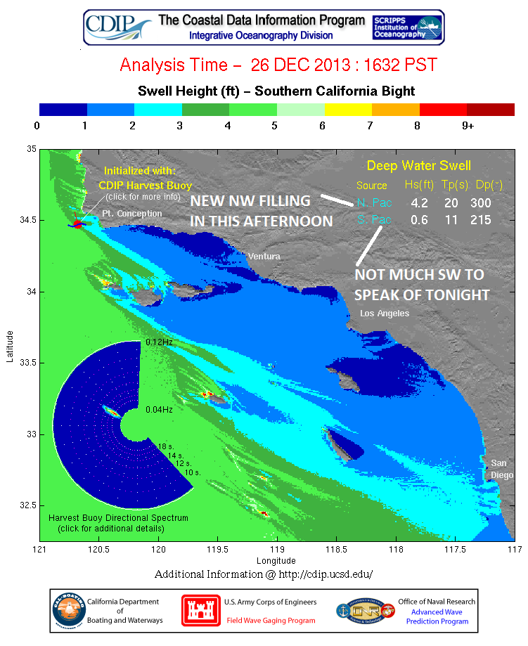
Next weekend looks to be pretty slow around here but we may get another fun chest high+ towards Monday. Nothing big but plenty fun for the next 7 days at least.

WEATHER:

Man are we hurting for some rain around here. We're going to roll into January with no big storms to speak of. I usually think of big storms as ones that drop an inch+ of rain and we usually get 2-3 of those a winter. A good soaking around here on the other hand is around 1/2". And a quick passing cold front will at least give us 1/4". So far this winter we've only had a few storms that give us 1/4" to 1/2"- none of those big 1" dumpers. So until then, we're left with sunny skies, mild Santa Ana conditions, and beach temps in the high 70's during the day. We have a weak cold front passing through on Saturday but our temps will only drop to the low 70's and some high clouds- something the people of Michigan would kill for this time of year. Then high pressure sets up yet again early next week and we're back to clear sunny skies and temps in the mid-70's again. No rain in sight.

BEST BET:
Hard to say- maybe Saturday or Wednesday when those two new fun NW swells fill in. And great weather too.

NEWS OF THE WEEK:

I'm beginning to tire of our perfect winter weather so I dug up some facts (with the help of the National Weather Service) of some REAL weather this time of year. My favorite: almost 30" of rain fell on Mt. Wilson during 12-17-12/27 in 1921. Can you imagine what the sandbars at the rivermouths in Southern California were like after those storms?! Solid.

2000: Santa Ana winds blew on 12/25 and on this day. Gusts of 87 mph were measured at Fremont Canyon. Damage and injuries occurred in Mira Loma, and in Orange County.

1997: It was 0° at Big Bear Lake and 4° at Big Bear Airport.

1988: A week of subfreezing temperatures hit Southern California starting on 12/24 and ending on 12/30. Five died as a result of the cold.

1987: A cold snap descended on the region. It was 9° at Mt. Laguna, and 22° in Valley Center on 12/25. On this day it was 15° in Julian and Mt. Laguna, 16° in Campo, 22° in Poway, 26° in El Cajon, 30° in Del Mar, and 37° in San Diego. Extensive damage to avocado and citrus crops resulted.

1971: A series of wet storms hit the region during this week starting on 12/22 and ending on 12/28. 19.44 inches fell in Lake Arrowhead, 15.26 inches in Lytle Creek, 12.31 inches in Big Bear Lake, 7.49 inches in Palomar Mountain, 5.45 inches in San Bernardino, 4.98 inches in Santa Ana, 3.92 inches in Redlands, 3.04 inches in Riverside, 2.28 inches in San Diego, 1.24 inches in Palm Springs, and 1.02 inches in Victorville. Extensive street flooding occurred across the region. This day marked the start of seven consecutive days (the most on record) of measurable precipitation in Victorville, which ended on 12/28. This also occurred on 2/18-24/2005, 1/13-19/1993, and 2/14-20/1980. These heavy storms started out warm on previous days, but then turned colder on this day to 12/28. The three day snowfall was up to two feet deep at Lake Arrowhead, 20 inches at Palomar Mountain, 15 inches at Big Bear Lake, 13 inches at Idyllwild, and six inches at Cuyamaca. Snow closed the Morongo Pass at Yucca Valley for a time.

1921: A succession of heavy storms from 12/17 to 12/27 produced a total of 29.38 inches at Mt. Wilson (only 1.48 inches had fallen there since 5/23). 30.64 inches fell at Squirrel Inn at Lake Arrowhead. From 12/24 to this day, 6.76 inches fell in LA. Widespread flooding of roads, bridges, railroads, farms, etc., resulted. Flooded areas along the Santa Ana and San Gabriel Rivers were easily seen from atop Mt. Wilson from the coast to 20 to 30 miles inland. Lake Arrowhead rose seven feet. On this day 2.10 inches fell in Redlands and 1.71 inches fell in San Bernardino.

1891: A period of very cold weather started on 12/23 and ended on 12/30. San Diego pools had ice 0.5 inch thick on the surface and ice one inch thick formed on oranges on trees in Mission Valley. The low temperature in San Diego was 32°, the lowest temperature on record for December.

PIC OF THE WEEK:

A few years ago I invested in a 'luxury' boat charter company that was going to operate out of 'Indo'. I gave $10k to a guy who said he was setting up the next 'Indies Trader' and we were going to be filthy rich. I transferred the funds to his bank account and didn't hear from him for a couple years. He then sent me this last week pic and said he was up and running. Turns out it was a 2 man panga boat he was operating and the wave was in an unstable Central American country. So I got that going for me in 2014.

Keep Surfing,

Michael W. Glenn
Jack of All Trades
Filling In for Dick Clark Next Week
First Goofyfoot to Make the Tour

Tuesday, December 24, 2013

Surf Check- Xmas Eve Edition


Christmas has come early this week. Great weather and a fun NW swell lighting up the beaches. Forgot the Xbox One! I want surf!
After the stormsurf last week, conditions cleaned up and a new NW filled in late Sunday night. We had overhead sets yesterday in south SD and shoulder high waves in north county SD. Today we still had some chest high waves in north county SD and south SD had head high waves. Look for the NW to drop further tomorrow and into Thursday morning.
Water temps are holding at 60 and the tides are pretty mellow- about 2' at sunrise, up to 3.5' after lunch, and down to 2' again at sunset.
As far as our weather goes, it's a typical Southern California Christmas. Sunny skies, clean conditions, and beach temps in the mid-70's. I can't remember the last time we had a White Christmas around here (i.e. rain). Models today show a storm in the Aleutians trying to gain strength but our high pressure will probably push it into the northwest this weekend- so maybe at best we'll get clouds or sprinkles towards Sunday. But no real rain in sight.
And our surf drought on Wednesday/Thursday won't last long. We have a couple storms on the charts today. Nothing significant but fun chest high+ NW (with SD getting head high+ waves again) should return late Thursday into Friday. We then get a back up NW swell for Saturday afternoon. And our good weather continues of course.
And charts show yet another storm trying to take shape off Japan later this week. If it holds, we'll get more fun chest high+ NW swell towards New Year's eve. A good way to kick off 2014!


Thursday, December 19, 2013

THE Surf Report- Early Edition


Christmas has come early.

SURF:

Not too shabby this past week. Good NW groundswell, some smaller SW groundswell underneath, and great weather. Most spots up and down the coast had head high sets with overhead waves in SD. Then things took a turn for the worse today as a weak storm moved in from the N and blew whatever swell we had left to bits. Look for the storm to depart tomorrow with some NW winds and jumbled head high sets+ from the NW. Saturday should be clean with leftover chest high sets from the NW.
We have another storm brewing in the north Pacific tonight which will give us a shout of head high NW on Sunday and more great weather. Looking like it's going to be a fun weekend of surf- a great way to kick of Xmas week.
Water temps are holding at 60 and tides the next few days are 3' at sunrise, about 5' at 11am, and down to 0' at sunset. Make sure to keep up to date on the waves/weather at Twitter/North County Surf.

FORECAST:

After a fun weekend of surf, the NW holds on Monday then fades by Tuesday. Unfortunately the 2nd half of next week looks to be pretty small- but hey- you're going to be busy on the 25th right?
Charts though do show another storm off the Aleutians forming mid-week and we should get more fun shoulder high NW next weekend. 

WEATHER:

Not a big storm today but it's breezy, cold, showery, and feels like winter. Rainfall totals will probably end up being around 1/3" with this one. Tomorrow should be clear and cold and we start to get a warm up early next week with a possible mild Santa Ana offshore wind event for Christmas. Ahhhh, nothing like Christmas in California. Temps in the high 70's, palm trees swaying, and girls on the beach. No rain in sight for the near future unfortunately.

BEST BET:
Sunday- new NW groundswell and great weather.

NEWS OF THE WEEK:

Next to Christmas, my 2nd favorite day of the year is the Winter Solstice. And it's just 2 days away- December 21st. For those of you not familiar with the Winter Solstice- it's the shortest day of the year in the northern hemisphere. Why does it rank higher than my birthday, October, or even Arbor Day for me? It's because the sun comes up earlier and sets later starting December 22nd. I can see just over the horizon my days of surfing before and after work coming to fruition. The USA Today newspaper shed some light on the subject today:

For people who like turning points, the winter solstice ranks right up there, bringing the end of short days and the return of more sun – ever so slowly. "It's kind of a gut thing. People don't like the dark," says Deborah Byrd, editor in chief of EarthSky.org. "After Christmas, you start to notice that the sun is setting later. Even a few minutes later is such a relief," she says. The winter solstice arrives at 5:11 p.m. on Dec. 21, marking the shortest day of the year. On that day the United States will get just nine hours and 32 minutes of daylight. "Up until winter solstice, the sun is moving southward from day to day. As it approaches solstice its southward march slows down," says Benjamin Burress, an astronomer at the Chabot Space & Science Center in Oakland. At the solstice the sun stops going south and pauses, motionless. "Then after solstice, it is again moving northward in the sky each day," he says. Solstice means "stationary sun." The solstice occurs because the Earth is tipped on its axis 23.5 degrees. In the northern hemisphere in the summer, the axis is pointing its most toward the sun on June 21. On that day the most light reaches us and we experience the longest day of the year and warmer temperatures: the summer solstice. The reverse is true on Dec. 21. Then the axis is pointing its most away from the sun, bringing less light and colder temperatures. That is the winter solstice, the longest night of the year. It's the opposite in the southern hemisphere, where Dec. 21 marks the longest day of the year and June 21 the shortest. The midpoints, on March 20 and Sept. 22, are known as the equinoxes. On these days the axis is exactly in between and night and day are the same length, 12 hours. All these dates loom large in myth and folklore. "Culturally, the solstices and equinoxes are typically used to denote either the beginnings of the seasons or the center points of the seasons," as in England, says Rick Kline, with the Spacecraft Planetary Imaging Facility at Cornell University in Ithaca, N.Y. "Christmas, Hanukkah, Kwanzaa and other holidays have arisen out of the solstices, equinoxes and the midpoints between them," he says. The solstice is regarded by many traditional societies as the turning point of the year and a time of great concern, says Edwin Krupp, director of the Griffith Observatory in Los Angeles. It is a "cosmological crisis point, in which the outcome of the coming year would be determined," he says. Many cultures have elaborate rituals at solstice time to ensure the return of the sun. In China the emperor would ascend the Temple of Heaven in Beijing to offer burned sacrifices as an intermediary between heaven and earth, Krupp says. It is no coincidence that Christmas and the solstice occur near each other, he says. "First, we don't really know when Christ was born, it's that simple," says Krupp. The Dec. 25 date was chosen by the church several centuries after the birth of Christ. "It had its antecedents in Rome, which already had a celebration called Dies Natalis Solis Invictus, the Birthday of the Unconquerable Sun," he says. For early peoples, for whom the sun was all light and all warmth, the solstice loomed large. But even for us it's a difficult time. "Between clock-change day and when people take down their Christmas lights, if I can get through that month, then I'm OK," Byrd says.

PIC OF THE WEEK:

To show my gratitude for all the years you've supported THE Surf Report, I'm giving all my loyal readers a 1 week luxury boat trip to Indo! Yes! Seriously. All you have to do is pay for airfare, taxes, tariffs, filing fee, a non-refundable deposit, title, finders fee, and appraisal (not sure on that last one). So really, it's about the same cost as paying for the boat trip yourself. But hey- it's the thought that count this time of year, right?

Keep Surfing,

Michael W. Glenn
Santa is my Wingman
Won a Lifetime Supply of Rice-A-Roni
Coined the Phrase 'Happy Hollowdays'

Tuesday, December 17, 2013

Surf Check

We've had some darn good surf lately- and great weather to boot. It's going to change for the worse (or better depending on who you ask) later this week. But first the good stuff.
The past few days had slowly building WNW groundswell with smaller SW groundswell underneath that peaked today with overhead sets most everywhere. The winds were also offshore in the mornings to pretty calm in the afternoons. Look for the NW to drop tomorrow while the SW holds. We'll still have head high sets though and clean conditions in the AM.
The only fly in the ointment the past few days were the extreme tides- about 4' at sunrise, up to 6' mid-morning, and down to 0' just before sunset. Water temps have also been holding about 60.
So why did I say at the top of the Surf Check that things will take a turn for the worse? Well, we've got another storm headed our way for late tomorrow into Friday morning. Nothing major but the low clouds/fog will return tomorrow afternoon and we'll have showers on Thursday. Models are forecasting about 1/4" at most. Look for S winds late tomorrow, SW winds Thursday morning, W winds late Thursday, and NW winds early Friday. We'll have clear cool skies for the weekend and another warm up is in store for Tuesday and most likely Christmas.
So with the storm on Thursday we'll also be getting a dose of overhead stormsurf! Hey- it keeps the crowds down.
Luckily for us, we have a storm NW of Hawaii tonight that's starting to take shape. If it holds, we'll have more head high surf towards Monday afternoon here in SD. And good weather is in store too. The 2nd half of the week looks pretty small unfortunately but models show more storms taking shape early next week which may give us more NW towards next weekend. So until then, enjoy the fading surf tomorrow, stormsurf on Thursday, and clean NW groundswell early next week!


Friday, December 13, 2013

THE Surf Report


I love Santa Ana(s)!

SURF:
Not much of a week for surf. After the quick shot of stormsurf on Sunday it's been pretty flat since then. Good weather though. Today we have some background SW swell for maybe waist high sets in far north county SD and stomach high waves in the OC.
Luckily for us we get a little boost out of the NW tomorrow for waist high waves.
We also get a late season SW filling in late Saturday for waist high waves in north county and chest high sets in the OC on Sunday. With the combo swell, north county should get chest high sets too. We also have an offshore 'Santa Ana' wind event setting up too (more on that in the Weather section below).
Water temps have finally dropped below 60 degrees (59 actually- don't panic just yet) and tides the next few days are 6' at sunrise, about 0' at 2pm, and up to 2' at sunset. Make sure to keep up to date on the waves/weather at Twitter/North County Surf

FORECAST:

After a fun weekend of surf, we get a reinforcement out of the NW late Monday into Tuesday for chest high waves in north county and shoulder high waves in SD. The SW should stick around too into Tuesday morning.
We get a slow down for the 2nd half of the week but models show some more fun NW showing up for next weekend.

WEATHER:

Mostly sunny skies this morning then high pressure sets up even stronger this weekend for a Santa Ana wind event. Look for warm offshore winds before lunch Saturday and Sunday and air temps near the high 70's. The OC will have gusty offshore winds. Winds back off Monday and Tuesday but we'll still have sunny skies and nice days. Late next week looks to have a return of clouds, cooler temps, and maybe a shot at showers.

BEST BET:
Looks like Sunday's the day- new small NW swell, fun SW swell, offshore winds, and beach temps in the high 70's. Or maybe that slightly bigger NW for next Tuesday with great weather too...

NEWS OF THE WEEK:

Considering how cold it's been lately (mid-30's at the beaches- seriously?) I thought we should take a look at some snow science this week. And considering you'll probably go snowboarding at least once this winter, you can amaze your friends while you wait in the those long lift lines at Mammoth.

Q: How are snowflakes formed? 
A:  A snowflake begins to form when an extremely cold water droplet freezes onto a pollen or dust particle in the sky. This creates an ice crystal. As the ice crystal falls to the ground, water vapor freezes onto the primary crystal, building new crystals – the six arms of the snowflake.

That’s the short answer. The more complex explanation is this:
These ice crystals that make up snowflakes are symmetrical (or patterned) because they reflect the internal order of the crystal’s water molecules as they arrange themselves in predetermined spaces (known as “crystallization”) to form a six-sided snowflake. Ultimately, it is the temperature at which a crystal forms — and to a lesser extent the humidity of the air — that determines the basic shape of the ice crystal. Thus, we see long needle-like crystals at 23 degrees F and very flat plate-like crystals at 5 degrees F. The intricate shape of a single arm of the snowflake is determined by the atmospheric conditions experienced by entire ice crystal as it falls. A crystal might begin to grow arms in one manner, and then minutes or even seconds later, slight changes in the surrounding temperature or humidity causes the crystal to grow in another way. Although the six-sided shape is always maintained, the ice crystal (and its six arms) may branch off in new directions. Because each arm experiences the same atmospheric conditions, the arms look identical.

Q: So, why are no two snowflakes exactly alike?
A: Well, that’s because individual snowflakes all follow slightly different paths from the sky to the ground —and thus encounter slightly different atmospheric conditions along the way. Therefore, they all tend to look unique, resembling everything from prisms and needles to the familiar lacy pattern

BEST OF THE BLOG:

Downtown Encinitas is known for Yoga studios, boutique restaurants, surf shops, and an explosion of bars disguised as eating establishments. But there's a new sheriff in town- and they're taking over the old Becker surf shop. Get the scoop at the North County Surf blog. And of course a mid-week Surf Check and an in-depth THE Surf Report; all of that and more in the blog below!

PIC OF THE WEEK:

How great would it be to have this thing barreling down on you?! How sketchy would it be to have this thing barreling down on you?!

Keep Surfing,

Michael W. Glenn
Mogul
Charger Fan. Again.
Quarterfinalist 1988 Sandy Beach Gotcha Pro

Thursday, December 12, 2013

North County Business News: Fore!


Back in the day when the economy was robust, north county San Diego was known as a golf mecca. With golf titans like Callaway and Taylor Made headquartered here, around 90 courses in the county, and favorite son Phil Mickelson living in Rancho Santa Fe, there were more golf shops than you could shake a 5 iron at. Well the recession took care of a few of the golf shops and Yoga studios filled the void as well as taking over the mecca crown.

As luck would have it ('luck' because I love to golf when the surf is flat), one golf shop is making inroads in an unlikely place. The old Becker Surf Shop at the Lumberyard in downtown Encinitas. Unlikely because downtown Encinitas is known for Yoga, boutique restaurants, surf shops, and an explosion of bars disguised as eating establishments. I happened to see some work going on at the old Becker shop (old being a loose term since the L.A. based shop was only around for about a year) and asked what was going on. Now granted, they're not very far along on the build out- nor should they be since this is the rainy season and golf is better in the summer sun- but I was told there was a golf store going in. By the looks of it, it will probably won't open until spring. And if you know the location, it's in a prime spot- right in the heart of downtown, next to Starbucks, and sits in plaza with the fountain- lots of foot traffic. When they get closer to opening, the North County Surf blog will have more details.

Tuesday, December 10, 2013

Surf Check

Another beautiful day out there and no surf to speak of. Actually, you might get a little waist high set from the NW down in San Diego but nothing here in north county.
Actually had some stormsurf late Saturday night and into Sunday morning where the passing cold front set up cold offshores but the swell dropped quickly after that as the skies cleared up. So the past few days around here have seen great conditions but tiny waves.
Water temps are hovering around 60- which is amazing considering how cold the air temps have been AND the winds have been offshore the past few days which causes the upwelling of colder water, but we're still safe to wear a 3/2 fullsuit.
Our weather should stay nice the next few days as we warm up slightly too. We have a weak disturbance below us today that may move into our area tomorrow night but look for sprinkles at most with this system. After that it's clear skies for the latter part of the week into the weekend. Temps may hit 70's at the beaches finally with lows in the high 50's at night.
As far as the surf goes, we had a little storm off Antarctica flare up a few days ago. Wasn't big and it was due south of us, so we may only see waist high sets from it in north county SD tomorrow with MAYBE an inconsistent chest high set for the OC. Better than nothing I guess.
After that we have a couple little swells- one from the NW and one from the SW- taking aim at us on Saturday. The NW is just some small waist high+ windswell and the SW is groundswell about the same size. Best combo spots should see some chest high sets. Along with the nice winter conditions this weekend, might be some fun little waves. Nothing solid yet though.

Models are showing some better NW groundswell for early next week. Hoping to get some chest high waves from it here in North County Monday afternoon and shoulder high sets in south SD.
And further out, the storm hasn't formed yet, but if the charts hold up we may get some good NW towards the weekend of the 20th. It's still a long ways away but hopefully things are starting to change for the better towards the end of the month. Now that would be a good Christmas present.