Thursday, January 25, 2024

THE Surf Report


You Ain't Seen NUTHIN' Yet.

SURF:

Rain is awesome. But the whole season all at once? Not so much. 


Plenty of surf this week saw plenty of run off too from the rain and the result was suspect water conditions. Today things cleaned up slightly and we had head high+ NW groundswell and clean conditions. High pressure sets up shop (temporarily- more on that in the WEATHER section below) and as it does, we'll have offshore winds in it's wake. 


On Friday, we have a quick reinforcement out of the NW for more shoulder high surf (bigger in SD) and another building shoulder high NW late Sunday. And here’s the sun, tides, and water temps for the upcoming weekend:
  • Sunrise and sunset:
    • 6:47 AM sunrise (6:30 paddle out)
    • 5:16 PM sunset (5:30 paddle in)
    • That's an 11 hour window to surf people. 
  • Water temps are still high 50's.
  • Along with the nice weather this weekend, the tides will also throw a monkey wrench into your surf sesh (again):
    • about 4' at sunrise
    • rising to 5.5' mid-morning
    • and dropping to -0.5' late afternoon
    • and back to 1' at sunset
FORECAST:

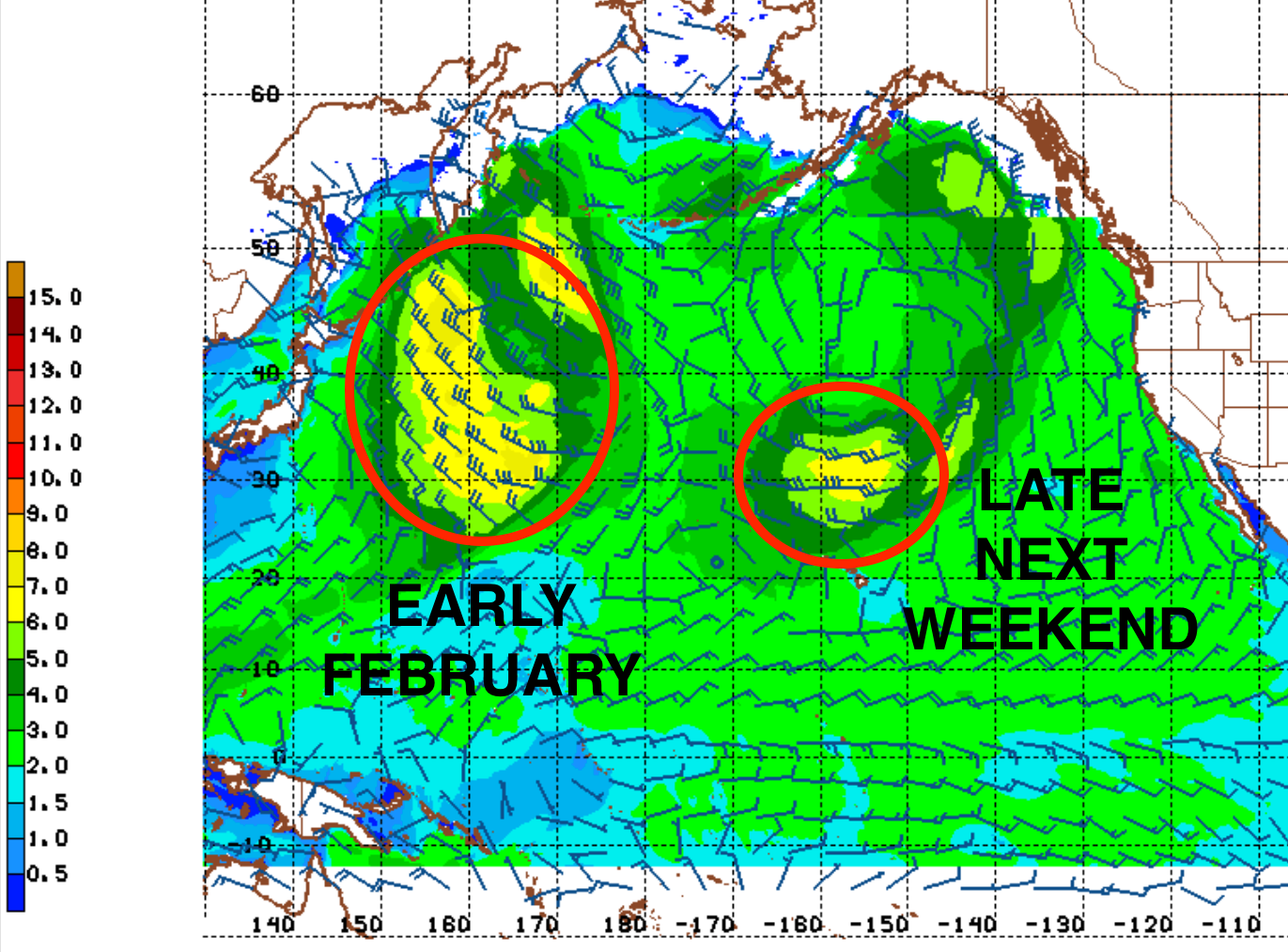
The building NW on Sunday peaks on Monday for head high waves in N County SD and overhead sets in SD. Tuesday is a transition day- then the storm door opens again. 


Look for building WNW on Wednesday for overhead surf- and suspect conditions. Models show Thursday and beyond being rainy, stormy, and big surf- with another pulse of large waves on Friday into the weekend and beyond. If anything changes between now and then, make sure to follow North County Surf on Twitter

WEATHER:


My scale for rain intensity is as follows:
  • 0.10"-0.25" = minor
  • upwards of 0.5" = showers/rain, not too significant, usually moves through the area quickly
  • 1" = solid storm, most of the area can handle it (i.e. minor road flooding, no mudslides, etc)
  • 2"+ = big storm, flooding/mudslides in certain areas, may last a day or two
  • 3+" = rare storm, cars swept away, building damage
Guess which one we had this week? Yep, 3" in N County SD and over 4" in S County SD. At least it wasn't as bad as the deluge back in mid-April 2020  when we had over 5" in 1 day and 7.5" in less than a week. Good for rivermouth sandbars- bad for everything else. So why am I mentioning this? Models are showing significant rain again for the 2nd half of next week. How much? Forecast charts call for either a ton- or just your typical winter storm(s). We need the rain- but I hope it doesn't come all at once! Regardless, here's what we have on tap for at least the next 7 days:
  • Friday: Sunny and nice for January. Temps 63/54
  • Saturday: Sunny and really nice. Temps 68/55.
  • Sunday: See above.
  • Monday/Tuesday: Still nice and slightly cooler at 65/54.
  • Wednesday: Showers start to arrive late? Temps 63/55.
  • Thursday and beyond: Batten down the hatches? Or at least grab an umbrella. 
BEST BET:

Looking pretty good this weekend with bookend swells early Friday and late Sunday ALONG with great weather. Fire up the Emergency Boardriding System again!:
  • Friday with good conditions and fun surf- beware the tides though.
  • Late Sunday/Monday with new swell and a low tide afternoons.
  • 2nd half of next week may be tricky as new swells roll in- but the weather does too...
NEWS OF THE WEEK:


Back in early December, rain was hard to come by and even though we were in the middle of an El Nino, I had a bit of nervous laughter. Sure the rain was coming, but when? Of course rain arrived a few days before Christmas and we had another good storm mid-January; but the icing on the cake was this week's downpour. As mentioned above, various spots along the OC and SD coasts received anywhere from 2.5" to 4.5". So before next week's expected storms arrive, where do we stand for the season?
  • Los Angeles: 5.6" so far. 96% of normal. 
  • Newport Beach: 3.65" so far. Only 67% of normal.
  • Oceanside: 5.58" so far and is at 104% of normal. 
  • San Diego: 5.06" so far and is 111% of normal.
Amazingly, with last year's La Nina, most locations at this point in time had 8-10" so far and were almost 200% of normal. So what do our current numbers mean? We're on track to have at least a normal winter or an above average El Nino winter. If the big rains arrive next week as expected, we can add another 3+" (at least) to our totals. So stick around and find out! 

BEST OF THE BLOG:


Just a reminder the world famous Surf Meeting is TOMORROW, Friday, January 26th and we got surf, sun, and smooth conditions finally. Want to expand your network? Want to support your community? WANT TO SURF MORE? Of course you do. Head down to Georges (south of the Chart House in Cardiff- across from Las Olas) at 8 AM to make some new connections, get a bite before work, and maybe grab a tube or two. Sponsored by our friends at Seawise Financial, it's a great way to start the weekend and give back to your community in the process. Thanks for supporting the North County Board Meeting and hit up northcountyboardmeeting@gmail.com with any questions!

PIC OF THE WEEK:


Guess what starts on Monday? Yep, you guessed it- the grandaddy of them all- the Pipe Masters. Looks like there's a fair amount of large surf headed to Hawaii too. Good luck rookies!

Keep Surfing, 
Michael W. Glenn
Colossal
Only Listen To Yacht Rock On My Yacht
Got Bit By A Seal And Have Been Frothing To Surf Ever Since

Thursday, January 18, 2024

THE Surf Report


Windows.

SURF:


The word of the day has nothing to do with double paned glass or Microsoft; but it does have everything to do with surfing. In particular- this weekend's waves. We've got some windy & wet weather headed our way so timing your session(s) will be of utmost importance. With that being said, fun but small waves this week and pleasant weather will be replaced by rain, solid surf, and a bit of a breeze. Friday has some leftover waist high+ WNW, a touch of new small SW, and nice conditions with a few clouds later in the day. 


For Saturday, the surf ramps up pretty quickly with overhead sets later in the day from the WNW and the winds will be suspect by mid-day out of the SW with showers arriving late afternoon. For Sunday, it's a transition day with decreasing showers, a touch of NW wind, and solid overhead surf. And here’s the sun, tides, and water temps for the upcoming weekend:
  • Sunrise and sunset:
    • 6:49 AM sunrise
    • 5:11 PM sunset
  • Water temps are still 58.
  • Along with the tricky weather this weekend, the tides will also throw a monkey wrench into your surf sesh:
    • about 5' at sunrise
    • dropping to -0.5' just after mid-day
    • and back up to 2.5' at sunset
FORECAST:

The weekend's weather was just an appetizer before the main course on Monday. Our first heavy rain of the new year will roll through and make a mess of any leftover surf we may have had from Sunday. Tuesday is a transition day as the weather cleans up but the water remains dirty. 


We do though see late in the day new head high+ WNW move in and high pressure should push the rain towards Nor-Cal. We then get another similar size swell/direction for late Thursday into Friday. 


Charts also show more good WNW around Monday the 29th and Thursday the 1st of February. Yes! If anything changes between now and then, make sure to follow North County Surf on Twitter. 

WEATHER:


Winter weather will finally be returning to southern CA the next few days- then it's back to high pressure and sunshine later next week. Here's what we have on tap for at least the next 7 days:
  • Friday: Mostly sunny with a chance of showers late. Temps 60/50
  • Saturday: Mostly cloudy and showers. Temps 62/52.
  • Sunday: Slight break in the showers early- then heavier rain later that night. Temps 60/52.
  • Monday: Rain and windy. Temps 60/52. 
  • Tuesday: Clearing. Temps 62/52.
  • Wednesday through next weekend: Sunny with temps mid-60's during the day and low 50's at night. 
BEST BET:

Might have to fire up the ol' Emergency Boardriding System later next week if the water/weather cleans up and the forecasted swells arrive:
  • Saturday morning with building WNW and semi-clean conditions.
  • Early Sunday with solid swell but suspect winds.
  • 2nd half of next week with clean conditions and good surf. EBS time. 
NEWS OF THE WEEK:


Oceanside, CA has always been a place of creativity when it comes to board shapers, cars, and the culinary scene. Not be outdone are the unique waves themselves, most recently created by the Army Corp of Engineers in the form of jetties in the 1960's. Following in their footsteps is Ocean Kamp, the wavepool and camping destination as reported by THE Surf Report last year (hopefully opening next year). And if that's not enough, Oceanside is looking at solutions to keep their sand from disappearing due to rising sea levels. One idea? An artificial reef/headland combo. Could this be the next surf spot in Oceanside? Here's the San Diego Union Tribune with the dirt- or should I say sand:

A plan to build headlands and an artificial reef has been selected from three proposals by international design firms for a pilot project to restore and retain sand on Oceanside’s eroded beaches. The Australian firm International Coastal Management submitted the concept, and the headlands would be small, rounded extensions of the beach possibly to be built at the ends of Tyson and Wisconsin streets. The exact sites will be determined later.

The raised headlands would be protected from the waves by rock barriers, similar to the area of the beach that supports the lifeguard headquarters building beneath the Oceanside pier. Instead of a building, the raised sandy surfaces would be topped by pedestrian paths, shade structures, fencing and native dune plants.

Also part of the ICM plan is an artificial underwater reef built of rocks, cobble and sand in fabric containers just beyond the waves between the two headlands, to slow erosive forces and protect the beach. The recommended plan is scheduled to go to the Oceanside City Council for approval Jan. 31.

“Our design concept has focused on delivering a sustainable nature-based approach ... using design elements that mimic those that occur naturally in the region,” the ICM proposal states. Three teams competing for the Re:Beach contract made their final pitch Dec. 13 to a jury of 10 community leaders, regional representatives and coastal scientists selected by city administrators. The city announced the jury’s recommendation last week.

If approved by the City Council, ICM will receive an award of at least $100,000 and will continue to work on a final design to be shovel-ready by the fall of 2025. “The project team will develop final engineering plans and pursue environmental compliance for the winning design alternative,” according to a Jan. 4 city news release. “The planning and environmental review process is anticipated to take one to two years, and construction could begin as early as 2026.”

Construction costs are estimated at $31.4 million, and so far no funding source has been identified. Generally such projects are paid for primarily with federal and state grants. Completion of the project also depends on obtaining approvals from federal, state and local agencies, including the California Coastal Commission.


The Coastal Commission has generally opposed installing hardened structures on the beach such as the rock-ringed headlands, but in recent months administrators appear to have softened their stance. “We will continue to work with the city and encourage their creativity,” said Kate Huckelbridge, the commission’s executive director, at a meeting in November. “It’s exactly the approach that we want people to take, to bring all the ideas to the table as we are trying to figure out how to adapt to sea-level rise.”

Oceanside, like all coastal cities in San Diego County, has been fighting beach erosion for years. The cities have benefited from local and regional sand replenishment programs that take sediment from construction projects, riverbeds, lagoons, harbors and nearshore deposits. The Oceanside City Council began an aggressive new approach in August 2021 when it voted to spend $1 million on plans and permits for beach groins to trap and hold sand on badly eroded beaches south of the pier. However, neighboring cities soon learned of the plan and went on record opposing groins or any hardened structure that could stop sand from flowing south in the ocean currents to their beaches.

Since then Oceanside has continued to pursue the project, but with more community outreach and an emphasis on the need to work cooperatively with other coastal cities. “Definitely, this is a very different process and a very different project from the one we were talking about a couple years ago with groins,” Oceanside Mayor Esther Sanchez said Thursday. “This ... seems to be the one with the least impact, small headlands and small artificial reef,” she said. “It’s exciting that a room full of people come out with broad support for the one project. That’s positive.”

Other cities are still watching Oceanside’s moves carefully, despite the ongoing outreach efforts. “Once the project undergoes the required studies and analysis, we will have a better understanding of any potential impacts on other nearby coastal cities like Carlsbad,” Kyle Lancaster, Carlsbad’s parks and recreation director, said Monday.

“Until then, we are continuing to monitor its progress and stay in touch with the project team in Oceanside,” Lancaster said. The two other teams chosen as finalists for the Re:Beach project were Deltares/MVRDV, which proposed building a peninsula off the beach to support biodiversity and recreational activities while serving as a type of breakwater to hold sand, and SCAPE, ESA and the Dredge Research Collaborative, which proposed the concept of a sand dune park with a layered beach at Tyson Street.

BEST OF THE BLOG:


The eggnog is empty, there are no more presents under the tree, and the the old guy in the red suit has headed back north. The only thing left is to kickstart the new year with a Surf Meeting! Looking to make 2024 one for the record books? Then make a resolution to get involved with the North County Board Meeting. Want to expand your network? Want to support your community? WANT TO SURF MORE? Of course you do. Head down to Georges (south of the Chart House in Cardiff) on Friday, January 26th at 8 AM to make some new connections, get a bite before work, and maybe grab a tube or two. Sponsored by our friends at Seawise Financial, it's a great way to start the weekend and give back to your community in the process. Thanks for the support and hit up northcountyboardmeeting@gmail.com with any questions!

PIC OF THE WEEK:


Forbidden fruit along the central CA coast. Unless of course you're one of the billionaires that owns a plot of land along this untamed paradise. 

Keep Surfing, 
Michael W. Glenn
Literally A Walking Wikipedia
Became A Billionaire By Stashing $$$ Under My Mattress
Started A Surf Brand With John John Florence & John Bam Bam Parmenter Called 'John Bam John Bam John'

Thursday, January 11, 2024

THE Surf Report


SURF:

The solid groundswells of December have been replaced by the windswells of January. Sure looks a lot like last winter unfortunately. 


Today we had another weak cold front dive down from the N and in its wake was... wait for it... windswell. For Friday, things clean up but the windswell backs off to the waist high+ range. On Saturday, it drops even more with just waist high sets towards SD. 


On Saturday night, there's yet another weak cold front moving through- with a little less wind- so Sunday looks to have windswell again with a touch of groundswell- but only chest high sets towards SD. And here’s the sun, tides, and water temps for the upcoming weekend:
  • Sunrise and sunset:
    • 6:51 AM sunrise
    • 5:03 PM sunset
  • Water temps have dropped to high 50's with all the NW wind this week. And with morning air temps in the low 40's... BRRRRR! Keep the 4/3, booties, gloves, and hood handy!

  • And tides are still extreme this weekend- but will mellow out next week. For the weekend though:
    • about 5' at sunrise
    • around 6' mid-morning
    • and down to -1' at sunset
FORECAST:

The small NW wind/groundswell combo holds into Monday then Tuesday/Wednesday look pretty small.


We've got a small storm on the charts N of Hawaii this weekend which may give fun chest high+ NW groundswell (finally) towards late Thursday. 


We may also have a small waist high off-season SW arriving late next week which would help the OC. And long range models show the N Pacific getting it's act together again and we should have good WNW groundswells to finish up the back half of January. If anything changes between now and then, make sure to follow North County Surf on Twitter!

WEATHER:


High pressure in the Eastern Pacific has been pushing storms to the N of us (bad for surf- good for snow in the Rockies) and this weekend is more of the same. Here's what we have on tap for at least the next 7 days:
  • Friday: Sunny. Temps low 60's to low 40's.
  • Saturday: Mostly sunny in the AM then the clouds move in for a chance of light showers late. Temps low 60's to low 40's
  • Sunday: Showers early and breezy early. Temps high 50's and low 40's.
  • Most of next week: Sunny and cool. Temps in the low 60's to low 40's
  • Models show high pressure potentially breaking down the back end of January so we could see more stormy weather (and larger swells).
BEST BET:
  • In the short term- late Friday with the low tide and dropping small swell
  • Monday with clean conditions and small but fun NW
  • Thursday with slightly bigger NW and clean conditions
  • Maybe the 2nd half of January!
NEWS OF THE WEEK:


It's no secret that the coast of California from San Francisco to San Diego was a dumping ground in the early to mid 1900's for the harmful chemical DDT and radioactive waste- like upwards of a half million barrels. And if that wasn't enough, it was also a site to pour millions of metric tons of petroleum and chemicals straight into the ocean (I think I'm gonna be sick). And the cherry on top? It's been discovered that our military also dumped munitions of the Southern California coast because... well, it that was easiest. Our friends at the Scripps Institute of Oceanography have mapped our local seafloor the past few years and found quite a bit of military waste (sorry dolphins). The LA Times summarized the results:

It’s not just toxic chemical waste and mysterious barrels that litter the seafloor off the coast of Los Angeles. Oceanographers have now discovered what appears to be a massive dumping ground of military weaponry. As part of an unprecedented effort to map and better understand the history of ocean dumping in the region, scientists have found a multitude of discarded munition boxes, smoke floats and depth charges lurking 3,000 feet underwater. Most appear to be from the World War II era, and it remains unclear what risk they might pose to the environment.

“We started to find the same objects by the dozens, if not hundreds, consistently… It actually took a few days to really understand what we were seeing on the seabed,” said Eric Terrill, who co-led the deep-ocean survey with Sophia Merrifield at UC San Diego’s Scripps Institution of Oceanography. “Who knew that right in our backyard, the more you look, the more you find.” Among the munitions documented were Hedgehog and Mark 9 depth charges — explosives that were typically dropped from warships to attack submarines. Researchers also identified Mark 1 smoke floats — chemical smoke munitions that were dropped by ships to mark locations or to conceal their movements.

These findings, made public last week, build on a stunning 2021 underwater sonar survey that identified tens of thousands of barrel-like objects between Los Angeles and Catalina Island. Merrifield and Terrill’s research team, assisted by a rare partnership with the U.S. Navy Supervisor of Salvage, set sail again last year — this time with even more advanced sonar technology, as well as a high-definition deep-sea camera that sought to visually identify as many objects as possible. Discarding military waste at sea was not uncommon in decades past, but this once-forgotten history of ocean dumping continues to haunt our environment today. (A WWII-era practice bomb, in fact, washed ashore just last week in Santa Cruz County after a particularly high tide.)


The U.S. Navy has confirmed that what the Scripps team discovered “are likely a result of World War II-era disposal practices” and noted in a statement that “disposal of munitions at sea at this location was approved at that time to ensure safe disposal when naval vessels returned to U.S. port.” Officials are now reviewing the latest Scripps findings and “determining the best path forward to ensure that the risk to human health and the environment is managed appropriately.” Public interest in the legacy of ocean-dumping in Southern California has intensified since the Los Angeles Times reported that as many as half a million barrels of DDT acid waste had been unaccounted for in the deep ocean, according to old shipping logs and a UC Santa Barbara study that provided the first real glimpse into how the Los Angeles coast became an industrial dumping ground.

Dozens of marine scientists and ecotoxicologists have since convened regularly to discuss the data gaps in our understanding of DDT, a pesticide (banned in 1972) that was largely manufactured in Los Angeles and was so powerful it poisoned birds and fish. Congress — at the urging of U.S. Sen. Alex Padilla (D-Calif.) and the late Sen. Dianne Feinstein (D-Calif.) — allocated more than $11 million to work on the issue, and Gov. Gavin Newsom also boosted further research with an additional $5.6 million.

In another recent plot twist, an exhaustive historical investigation by the U.S. Environmental Protection Agency concluded that the pesticide waste had not actually been contained in barrels — rather, the chemicals were poured straight into the ocean from massive tank barges. In the process of digging up old records, the EPA also discovered that from the 1930s to the early 1970s, 13 other areas off the Southern California coast had also been approved for dumping of military explosives, radioactive waste and various refinery byproducts — including 3 million metric tons of petroleum waste. “When the deepwater dumping was first uncovered in more detail by the team at UC Santa Barbara, the response was, ‘Oh, my gosh, this is the tip of the iceberg.’ And now we’re seeing just how big this iceberg is — we still don’t even know how big it is,” said Mark Gold, an environmental scientist at the Natural Resources Defense Council who has worked on the DDT problem since the 1990s. “What’s scary — as if we needed it to be more scary — is that we’re now up to more than 100 square miles of contamination from this dumpsite, with high DDT concentrations at depths that nobody’s even ever looked before, and now we’re seeing all the other stuff that was dumped as well,” he said. “And it’s only what we see, from the standpoint of big munitions, as opposed to: How do we know there weren’t other chemicals that were dumped by the Department of Defense?”

David Valentine, the UC Santa Barbara scientist whose marine research team first came across dozens of eerie-looking barrels, also emphasized that the less-visible pollution is more cause for concern. The legacy of DDT contamination is still haunting sea lions and dolphins in mysterious ways, and fellow researchers have traced high concentrations of the forever chemical all the way up the marine food chain to critically endangered condors. “We can’t lose sight of the 500-pound gorilla down there, which is the massive amounts of chemical waste that was dumped and spread all over the place,” said Valentine, who noted that the contents of the barrels his team discovered remain a mystery. “Now that we know that the military had their thing going on, and that the chemical dumping was being bulk dumped, it really begs the question: So what else could have required being contained in these barrels?” he said.

Valentine, who has also been working with a number of scientists to piece together how DDT might be remobilizing from the seafloor, added that the latest high-resolution imaging from Scripps is instrumental in helping the entire research community understand what the seafloor actually looks like. The deepest parts of the seafloor between Los Angeles and Catalina Island, in fact, had never been mapped before in this way. Locating specific objects across such a wide swath of seafloor has been likened to searching for the smallest needles in the largest haystack. On the most recent expedition, a crew of nine Scripps researchers and 10 specialists from the Navy’s Supervisor of Salvage scanned the seafloor for more than 300 hours — capturing as many images as possible with high-resolution technology not typically available to scientists.


Patterns started to emerge. Object after object came into view, and the scientists found themselves processing and interpreting an overwhelming amount of data in live time. Terrill, an oceanographer who also specializes in scouring the deep sea for downed military aircraft as a co-founder of the nonprofit Project Recover, tapped an underwater archaeologist on his team to help identify the vintage military debris.

Another surprise for researchers was the discovery of scores of whale skeletons and carcasses, known as whale falls. Advanced sonar readings pinpointed potentially more than 60 whale falls, and researchers were able to visually confirm seven with their camera system. Craig Smith, a professor emeritus of oceanography at the University of Hawaii who has dedicated much of his life to studying whale falls, noted that this finding is particularly groundbreaking in his field. Across the entire world, only about 50 naturally occurring whale falls have ever been identified, so locating 60 more off the coast of Los Angeles alone essentially doubles the number of known whale falls. Many questions remain on why there appears to be such a high concentration of dead whales slowly decomposing off the coast of Southern California. Smith and his colleagues are eager to study this further.

“When we do population-level calculations, we estimate there may be on the order of 600,000 or more whale falls in the global ocean. But they fall more or less randomly, so they’re hard to find,” said Smith, who noted that whale falls become fascinating yet elusive ecosystems for deep-sea critters. Merrifield, the physical oceanographer who co-led the Scripps expedition, noted there remains an immense amount of new data to refine and analyze. Her team was able to capture high-resolution images of different seafloor textures, for example, as well as mounds that might indicate small burrowing animals that could stir up any chemicals half-buried in the sediment.

“New technologies are really changing the way we look at the seafloor, and there’s interdisciplinary problems from microbiology and remediation, to chemistry, to geology, to physical oceanography and transport that require all sorts of specialists to come together,” she said. “I hope the takeaway here is that maybe we didn’t find what we thought we were going to find, but we found a lot of really important objects and insights that will hopefully lead to really good scientific outcomes for the community.”

PIC OF THE WEEK:


Got the new Apple Vision Pro. I put this image on my lock screen. Totally worth the $3500. 

Keep Surfing, 
Michael W. Glenn
Charming
I Hardly Knew Ye Fruit Stripe
Just Like I Told The Guy On ABC, Danger Is My Business!

Thursday, January 4, 2024

THE Surf Report


El Nino Meet Baby New Year.

SURF:

Besides the big swells of January and December 2023, last year was pretty much a non-event. So I wholeheartedly welcome 2024 to my surfing schedule. 


This past week saw a bit of everything- solid surf again, windy conditions, good weather, rainy showers (am I missing anything?) and this weekend and beyond will be more of the same. For Friday, we have a continuation of NW wind/ground swell for chest high+ surf, then better head high+ NW on Saturday (and bigger in SD). 


Saturday night though, a cold front comes ripping through the area and we've got showers early on Sunday, then gusty 30 mph WNW winds on Sunday- and big storm surf. And here’s the sun, tides, and water temps for the upcoming weekend:
  • Sunrise and sunset:
    • 6:52 AM sunrise
    • 4:58 PM sunset
  • Water temps are barely hanging on to 60- and may drop more once the winds kick in Sunday.
  • And tides are starting to fluctuate this weekend- and really get extreme next week:
    • about 4' at sunrise
    • just above 0' at lunch
    • and up to 2' at sunset
    • then... tides are almost 7' at sunrise next week and almost -2' late afternoon
FORECAST:

After a windy and wooly Sunday, Monday morning looks to be cleaner with leftover head high NW wind/groundswell. Tuesday/Wednesday has nice weather but not much surf. 


Thursday into next weekend, models show another windy cold front coming through for a chance of showers and bumpy overhead surf again. If anything changes between now and then, make sure to follow North County Surf on Twitter!

WEATHER:


Big surf, showers, and windy conditions so far this winter- but we're due for more heavy rain. Maybe towards the end of the month- but for now- just cool conditions and showers. Here's what we have on tap for at least the next 7 days:
  • Friday: Mostly sunny. Temps low 60's to low 40's.
  • Saturday: Mostly sunny in the AM then the clouds move in for showers late. Temps low 60's to low 40's
  • Sunday: Showers early and WINDY. Gust could be 40 mph along the coast with sunny skies in the afternoon. Temps high 50's and low 40's.
  • Monday to Wednesday: Sunny and more low 60's during the day and low 40's at night.
  • Showers again late in the week?....
BEST BET:
  • No real ground swells to speak of and windy conditions the next 7 days so choose your windows to surf wisely! 
  • Friday with leftover smaller WNW and clean conditions.
  • Same goes for next Monday.
NEWS OF THE WEEK:

2023 was a wild year for waves and weather around here. What was supposed to be La Nina conditions (i.e lower than average rainfall), saw plenty of rain, bombing swells to book end the year, and even a tropical storm. I'm sure I forgot to mention something; if so, here's some highlights (or lowlights depending on how you look at it) from the San Diego office of the National Weather Service:


And even though the storm tracks of most hurricanes in the Eastern Pacific this summer weren't ideal for us surfers, it was active nonetheless due to an El Nino fueled ocean. Normally we'd have:
  • 15 named storms
  • 8 hurricanes
  • and 4 major hurricanes...
For 2023 we ended up with:
  • 17 named storms
  • 10 hurricanes
  • and 8 major hurricanes
El Nino is forecasted to last through the spring of 2024, so hopefully us wave & weather nerds will see some more of the same in the coming months.

PIC OF THE WEEK:


With the recent XXL groundswells and negative tides, mysto spots along the CA coast came to life. Like this gem in... wouldn't you like to know. 

Keep Surfing, 
Michael W. Glenn
Cool, Calm, & Collected
Best Man At Gerry & Theresa's Wedding
This Year's Triple Crown Champ By Default