Thursday, June 26, 2014

THE Surf Report- Early Edition


Not big. But darn fun.

SURF:
This is the way summer is supposed to be: Fun surf, warm water, and the sun comes out by mid-day.
Lots of SW/NW this past week to give us chest high+ waves in town and head high+ waves in the OC.
We have more SW filling in tomorrow as well as a holding NW windswell for more chest high waves here and shoulder high sets towards the OC. The only fly in the ointment is that June Gloom may hang around a little longer than usual tomorrow- but hey- we've had great weather so far this year so I can't complain. The combo swell holds on Saturday then starts to back off on Sunday while the weather starts to improve- kind of a Catch 22. In regards to our water temps, Oceanside was 71 today, Dana Point 72, and La Jolla had a reading of 73. Pretty amazing for the BEGINNING of summer. I'm guessing we'll be in the high 70's a few days this August. I'm talking about water temps here people. Unreal.
Tides the next few days are all over the place; about -1' at sunrise, up to 4' before lunch, down slightly to 2' late afternoon, and up to 5' at sunset. The early morning clouds tomorrow, maybe a hint of S wind, and the negative tide may make it look pretty ugly first thing. But hang in there! The afternoon should look more appealing. Make sure to keep up to  date on the waves/weather at Twitter/North County Surf.

FORECAST:

After the SW/NW backs off on Sunday, we get a small late season NW groundswell/windswell combo on Monday. Look for waist high+ waves here and chest high waves in SD.
By mid-week, the NW windswell continues and models hint at a little hurricane trying to get it's act together. If that's the case, the OC may get some chest high waves from it towards Thursday.
On it's heels for the 4th of July weekend is a fun SW swell arriving on Friday. Look for chest high+ waves here and shoulder high+ waves for the OC. All in all some fun waves next week and great weather (more on that below)

WEATHER:

We've got a late season cold front moving through the western states tonight that will make the June Gloom last a little longer tomorrow. Hoping to see some sun at the beaches on Friday but it will be dicey. Good news is that high pressure builds this weekend and we'll have great weather going into Sunday. Early next week we're a few degrees above normal with air temps in the mid to high 70's, less low clouds and fog in the night/mornings, and that should last into the July 4th weekend. Models also hint at our first surge of monsoon moisture rolling into the desert SW. Hopefully it's the start of 'tropical' type weather for us at the beaches by mid-July. 

BEST BET:
Tomorrow should be fun with small combo swell but the weather may be a bit ugly. So I'm claiming July 4th- more SW if the models hold, a continuation of the NW windswell, and great weather. Plus water temps holding in the low 70's. Support your local surf shop and buy some new boardies this week! (Just wanted to throw that in there).
 
NEWS OF THE WEEK:

So the winter that never was is officially coming to a close this weekend. And by that I mean the rainy season of July 1st, 2013 to June 30th, 2014. Barring any monsoons this weekend (which I'm pretty confident we can rule out), we officially had:

-Newport Beach: 3.64" of rain. 34% of normal
-Oceanside: 4.20" of rain. 31% of normal
-San Diego: 5.06" of rain. 49% of normal

So there you have it. The rain gauges showed less than 50% of normal for our season. Considering we've had years upon years of below normal rain, this is a problem. So how do we solve it? El Nino of course. If the upcoming '14/'15 El Nino this winter is anything like the '69/'70, '82/'83, or '97/'98 winters, we should get somewhere in the neighborhood of 15-20" of rain. Unbelievable if you think about it. One major El Nino storm will drop around 2-3" of rain; just about the same amount Newport Beach had the ENTIRE season this year. My word of advice: Get your house prepared before October...

PIC OF THE WEEK:

Not the biggest wave nor the biggest barrel but there's no way I'd turn my back on this thing. We'll, I'm goofyfoot, so technically I'd have to turn my back to ride this thing, but you know what I mean.

Keep Surfing,

Michael W. Glenn
More Interesting Than The Most Interesting Man In The World
Survived The Group of Death
Guinness World Record Holder, Most Spray, 25.7 Gallons

Tuesday, June 24, 2014

Surf Check


Finally have some fun SW/NW in the water today with peaking SW and a touch of NW. Sets are shoulder high and bigger towards the OC. Beachbreaks are peaky and there's some little barrels out there.

Clouds are breaking up, wind is light from the W and water temps are holding at 70. Looks like it's time for a surf. Beware the tides though! We've got a 0' low tide at sunrise, up to 4' mid-morning, down to 1' after lunch, and up to 6' at sunset.

As the SW starts to back off tomorrow, we've got more NW windswell filling in. Look for wave heights to be about the same as today.

As far as our summer weather goes, we've got the typical night and morning low clouds/fog burning off to mild sunshine in the afternoons with beach temps in the low 70's. There's a weak low pressure system moving by to the north this weekend which will make the low clouds/fog a little more persistent at the coast and temps will be in the high 60's to low 70's. By early next week, high pressure builds again, the low clouds/fog will burn off quicker, and we'll be back to the mid-70's along the coast.

As the current SW backs off the 2nd half of this week, we get more SW towards Friday and into the weekend. Look for more shoulder high sets and overhead waves in the OC.
And the winds off Point Conception pretty much will blow off and on the next few days sending more waist high NW windswell our way which will help peak up the beachbreaks. And the weak cold front that will roll through Northern California this weekend will send a shot of NW groundswell our way early next week. Nothing big but SD should have some chest high+ waves. After that the north and south Pacific take a breather and it looks pretty small the middle of next week. The tropics have also been quiet this past week but that can all change within a few days.


Friday, June 20, 2014

THE Surf Report


Summertime... and the living's easy.

SURF:

Not a lot happening the past few days and today is about the same. Just a small S swell showing best towards the OC with tiny NW windswell mixed. Most spots around town are knee high+ with the odd waist high+ set in the OC. We do though have a couple swells creeping our way for the weekend.
More SW groundswell fills in tomorrow as well as NW windswell swell. Nothing major but we should get an inconsistent chest high set in the far north part of the county late on Saturday. By Sunday it should be consistently waist to chest high from the combo swells with the OC pulling in shoulder high sets. Add in good beach weather, water temps in the low 70's, and you're looking at a fun weekend.
Tides are around 4' at sunrise, down to 1' late morning, up to 5.5' at dinner, and down to 4' at sunset. Make sure to keep up to  date on the waves/weather at Twitter/North County Surf.

FORECAST:

The small SW that is filling in this weekend will fill in more on Monday/Tuesday and peak on Wednesday.
At the same time, more NW windswell is being shown by the models so we have some head high sets on Wednesday. Beachbreaks will be peaky. And did I mention the water is in the low 70's?!
The SW backs off slightly Thursday/Friday but still hangs around for a couple days then we should get another pulse of small but fun SW for next weekend if the forecast charts hold up.

WEATHER:

Great way to start the 1st day of summer (it's Saturday in case you didn't know). High pressure in northern Baja is keeping our low clouds to a minimum and we'll have great beach weather by mid-morning. Air temps will be in the mid-70's on Saturday and all around it's looking like summer is right on schedule. A weak low pressure system will move by to the north on Sunday but all it will do is make the clouds take a little longer to burn off but no real June Gloom to speak of. High pressure then kicks in again for Tuesday and we're back to great weather mid-week.

BEST BET:
Peaking NW windswell on Tuesday but building SW swell. Then the SW peaks on Wednesday as the NW starts to back off. Either way the weather will be nice and the water warm. Just depends on your schedule. Cancel those meetings!
 
NEWS OF THE WEEK:

This is the honeymoon phase of the El Nino; hasn't kicked in 100% yet so we're left with great weather (June Gloom where art thou?) and we get to wear trunks in the spring time. Summer is kicking in this weekend so we should start to see a little more tropical weather towards early July, even warmer water temps, and then the full blown El Nino will come pouring down from the heavens this winter. But before I get ahead of myself, Saturday, June 21, marks the first official day of summer in the Northern Hemisphere, when the sun reaches its northernmost point in the sky. AND... the summer solstice, as it's called, is the longest day of the year. The sun comes up around 5:40am (which means you can paddle out around 5:30am if there isn't much fog) and goes down around 8pm (which means you can get a few waves in until 8:15pm if there isn't much fog. Heck- that's almost 15 hours of surfing time.) So with that being said, here are five facts to know about the first day of summer.

When does the summer solstice begin, exactly?
In the Northern Hemisphere, the summer solstice begins at 6:51 a.m. EDT on June 21, according to Almanac.com, officially ringing in summer. The date brings the year’s longest stretch of daylight. Though the hours of sunlight depend on location, many areas will see up to 16 hours’ worth of light on Saturday.

Why does the solstice occur?
The word solstice is from the Latin solstitium from sol (sun) and stitium (to stop), because it appears the sun stops at the solstice. The solstice happens twice annually due to the Earth’s axis of rotation. Depending on the calendar year, the summer solstice happens annually in December for the Southern Hemisphere and on June 20 or 21 in the northern half of the world. For science aficionados, the summer solstice occurs precisely when the Earth's axial tilt is most inclined toward the sun, at the degree of 23° 26', its most extreme. In June, the tilt is toward the sun in the Northern Hemisphere, while the second yearly solstice, the winter solstice, in December, the tilt is away from the sun in the Southern Hemisphere.

How is the solstice celebrated?
The solstice marks the first day of summer in the Northern Hemisphere, and that means flip-flops, beach trips and barbecues. In southern England, thousands flock to Stonehenge to see the sun rise from the vantage point of the 4,000-year-old solar monument. The summer solstice is also a time of celebration for Christians and Pagans. In Christianity, the first day of summer marks the festival of St. John the Baptist, and in Paganism followers celebrate what they call "midsummer" with bonfires and feasts.

Is it the longest day of the year?
The summer solstice has the longest hours of daylight for the Northern Hemisphere. The sun, which usually rises directly in the east, rises north of east and sets north of west. This means the sun is in the sky for a longer period of time, yielding more daylight.

Why do the warmest days of summer generally come long after the solstice?
It takes a month or two for some geographic areas to see their warmest days simply because it takes the Earth time to warm up. In fact, solstices do not mark the start of winter or summer at all; they are actually the midpoint of each season. Almanac.com calls this phenomenon, when the land and oceans release stored heat back into the atmosphere much later than the first day of summer, the “seasonal temperature lag."

So there you have it. Enjoy the summer solstice this weekend before everything gets turned upside down by El Nino this winter.

PIC OF THE WEEK:

If I was a surf explorer (great work if you can find it), I'd want to stumble upon this place. Not too big but plenty of size to get your game on. Tropical weather of course. Nothing but trunks. And some little shack on the point where you could crash at night. Sure you'd have to hunt for your own food and fend off the natives- but heck- I do that every night at home with the family!

Keep Surfing,

Michael W. Glenn
Out of This World
Filling in for Jozy
2008 'BK Man-Turns' Award Winner

Wednesday, June 18, 2014

Surf Check

Had some fun surf earlier in the week. That little SW wouldn't die and the NW windswell was bigger than expected.
Today we have a continuation of the NW windswell that is peaking and there's new SW in the water too.
The SW was churned out by some unimpressive small storms last week. We're only getting waist high waves here in SD from the combo swell and the OC is getting a rare chest high set today.
Wind is currently blowing WSW at 10 and water temps are surprisingly warm at 70 degrees today. Pretty awesome for spring. Even though the W wind has been blowing this past week, it isn't the NW 'death' wind which causes upwelling and cold water. I also think the lack of May Gray/June Gloom has helped the sun stick around longer and warmed our water temps up this spring; as well as the building El Nino being a benefit to us also. How warm is our water going to be this August?! Tides are a bit funky the next couple days with 2' tides at sunrise, down to 0' around 9am, up to 5' late afternoon, and down to 2' again at sunset.
Speaking of a lack of June Gloom, it looks like we'll be that way at least through the weekend. Sure we'll have low clouds and fog in the nights/mornings, but we've had sunny skies at the beach by 9am this past week. That's been fantastic. High pressure will build slightly this weekend and we'll have plenty of sun by mid-morning and air temps in the mid-70's. We may have a weak cold front move by to the north towards the middle of next week which may help the clouds stick around a little longer at the coast, but we should have sun most afternoons at the coast.
So when are we getting good surf again? Well, first up is some more NW windswell filling in towards Friday and peaking on Sunday. Look for waist high NW on Friday building to chest high on Sunday.
Right on it's heels is some more SW for waist high waves on Friday with chest high sets in the OC. Behind that is a better storm which will give SD chest high sets around the 23rd and head high sets for the OC. This weekend should at least be fun with the peaking NW and building SW for shoulder high combo sets. So until then, get your work done and get some waves on Saturday and Sunday with nice weather and warm water temps. A good way to kick off the 1st day of summer.


Friday, June 13, 2014

THE Surf Report


Please continue to hold for the next available swell. 

SURF:

Nothing big the past week but some fun shoulder high waves the closer you got to the OC. Today is just a shell of it's former self with leftover waist high SW groundswell and a touch of NW windswell. The OC still has chest high waves but I'm not making an effort today to drive up there.
Tomorrow we get a little boost from the NW windswell again and there's some remnant knee high SW in the water. Won't be flat this weekend but it will be small.
As far as Hurricane Cristina is concerned, she's already dying this morning with winds clocked at 100mph (after peaking yesterday at 150) and she's STILL not in our swell window. When she finally does peek around the corner of Baja, she'll only be a tropical storm AND moving away from us. So don't expect any swell from her. Bummer.
Water temps have been hovering around 68 degrees and tides the next few days are -1.5' at sunrise, up to 4.5' before lunch, down to 1' late afternoon, and back up to 4' at sunset. Make sure to keep up to  date on the waves/weather at Twitter/North County Surf.

FORECAST:
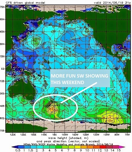
Still no big storms in the Pacific the past few days (besides Cristina- but she's hiding behind Baja) so we don't have much on tap next week.
There's been a couple little disorganized storms off Antarctica but we'll only get waist high waves from them around Wednesday.
Charts also show the NW windswell kicking up again but that's only good for waist high waves on Wednesday too.
Models have a good storm FINALLY taking shape next week in the southern hemisphere which would give us good SW towards the 23rd, so I'm keeping an eye on that one. And of course the tropics have been supercharged as of late so maybe we'll get more hurricane activity and a chance of a S swell.

WEATHER:

Still no June Gloom. Sure we've had low clouds and fog this past week, but it really hasn't stuck around all day. We've had pleasant afternoons at the beaches once the clouds burn off mid-day. Look for the same for the upcoming week with temps in the low 70's. Not too shabby.

BEST BET:
Does waist high+ combo swell really count as 'best'? If so, probably this Wednesday with a little SW and a little NW.
 
NEWS OF THE WEEK:

All the talk this spring has been about the return of El Nino. Signs in the tropics have been pointing to a real barn burner down there. We’ve already had the strongest hurricane on record for May (Amanda), the quickest intensification of a hurricane on record (Cristina went from a tropical storm to a category 4 in about 24 hours), and it's the first time we’ve had two category 4 hurricanes before the month of July even started. What’s going to happen once summer hits?! And we’re not even talking about the effects of El Nino this winter. With the hurricanes already kicking into high gear, the effect that El Niño has on both the Atlantic and Pacific hurricanes seasons is worth exploring. The hurricane impacts of El Niño and its counterpart La Niña are like a see-saw between the Pacific and Atlantic oceans, strengthening hurricane activity in one region while weakening it in the other.

Simply put, El Niño favors stronger hurricane activity in the central and eastern Pacific basins, and suppresses it in the Atlantic basin. Conversely, La Niña suppresses hurricane activity in the central and eastern Pacific basins, and enhances it in the Atlantic basin. These impacts are primarily caused by changes in the vertical wind shear, which refers to the change in wind speed and direction between roughly 5,000-35,000 ft. above the ground. Strong vertical wind shear can rip a developing hurricane apart, or even prevent it from forming.

ENSO perturbs tropical and subtropical atmospheric circulation:
During El Niño, the area of tropical Pacific convection and its associated Hadley circulation expand eastward from the western Pacific, sometimes extending to the west coast of South America. (A tutorial on El Niño and La Niña can be found at the NOAA Climate Prediction Center website.) At the same time, the equatorial Walker circulation is weaker than average.

These conditions produce an anomalous upper-level, ridge-trough pattern in the subtropics, with an amplified ridge over the subtropical Pacific in the area north of the enhanced convection, and a downstream trough over the Caribbean Sea and western tropical Atlantic. Over the central and eastern Pacific, the enhanced subtropical ridge is associated with weaker upper-level winds and reduced vertical wind shear, which favors more hurricane activity.

Over the Atlantic basin, the amplified trough is associated with stronger upper-level westerly winds and stronger lower-level easterly trade winds, both of which increase the vertical wind shear and suppress hurricane activity. In addition to enhanced vertical wind shear, El Niño suppresses Atlantic hurricane activity by increasing the amount of sinking motion and increasing the atmospheric stability.

La Niña has opposite impacts across the Pacific and Atlantic basins. During La Niña, the area of tropical convection and its Hadley circulation is retracted westward to the western Pacific and Indonesia, and the equatorial Walker circulation is enhanced. Convection is typically absent across the eastern half of the equatorial Pacific.

In the upper atmosphere, these conditions produce an amplified trough over the subtropical Pacific in the area north of the suppressed convection, and a downstream ridge over the Caribbean Sea and western tropical Atlantic. Over the central and eastern subtropical Pacific, the enhanced trough is associated with stronger upper-level winds and stronger vertical wind shear, which suppress hurricane activity. Over the Atlantic basin, the anomalous upper-level ridge is associated with weaker upper- and lower- level winds, both of which reduce the vertical wind shear and increased hurricane activity. La Niña also favors increased Atlantic hurricane activity by decreasing the amount of sinking motion and decreasing the atmospheric stability.


ENSO phases interact with other climate patterns that influence hurricanes:
Another prominent climate factor to influence Atlantic hurricane activity is the Atlantic Multi-Decadal Oscillation (AMO) (Goldenberg et al. 2001, Bell and Chelliah 2006). The warm phase of the AMO is associated with high-activity eras for Atlantic hurricanes, such as has been in place since 1995. Conversely, the cold phase of the AMO is associated with low-activity eras (such as the period 1971-1994).

The warm phase of the AMO reflects warmer SSTs across the Atlantic hurricane Main Development Region. A key atmospheric feature of this pattern is a stronger West African monsoon, which produces a westward extension of the upper-level easterly winds (near 35,000 ft), along with weaker easterly trade winds in the lower atmosphere (near 5,000 ft).

This wind pattern is very conducive to increased Atlantic hurricane activity, partly because it results in weaker vertical wind shear. The weaker trade winds also contribute to a more conducive structure (i.e. increased cyclonic shear) of the mid-level (near 10,000 ft) African Easterly Jet (AEJ), favoring hurricane development from tropical cloud systems (i.e. easterly waves) moving westward from Africa. At the same time, these wind patterns are associated with a more northward push into the MDR of deep tropical moisture and unstable air, each of which also favors stronger hurricanes.

The hurricane activity in a given season often reflects a combination of the multi-decadal signals and ENSO. During an Atlantic high-activity era, El Niño typically results in a near-normal season, and La Niña produces an above-normal season. During an Atlantic low-activity era, El Niño typically results in a below-normal season and La Niña results in a near-normal season (Bell and Chelliah 2006). 

Similarly for the central and eastern Pacific basins, the combination of a low-activity era and El Niño often produces a near-normal season, while La Niña produces a below-normal season. For a Pacific high-activity era, El Niño often produces an above-normal season, while La Niña produces a near-normal season. And so far, this prognosis seems right on track.

BEST OF THE BLOG:

Haven't seen firing surf lately? The 2nd installment of the 'Stoke! Surf Gallery' is up. Some of the best shots over the years from the Pic of the Week. I've been doing The Surf Report for 20 years now and 15 of those years have had the Pic of the Week- so I thought it was about time to open the treasure chest and post them on the blog. As well as a mid-week Surf Check and an in-depth THE Surf Report. All of that and more in the blog below!

PIC OF THE WEEK:

What's better: East or West Coast? My vote... East Coast. Don't laugh. Hear me out first: 4 times the amount of world champions. Tropical weather 24/7 (ok- that's a stretch- only south Florida). EVERYONE is stoked on surfing. Drive your truck up onto the sand. And then this- some mysto left sand point on the Outer Banks. Imagine if this was in California?! There'd be 3 Starbucks on that point, 1,000 kooks in the line up, and a power plant ruining the view.

Keep Surfing,

Michael W. Glenn
Exploded On The Scene
Genie Every Third Friday
Godfather of the Floater