Friday, February 27, 2015

THE Surf Report


Winter = Weather + Waves

SURF:

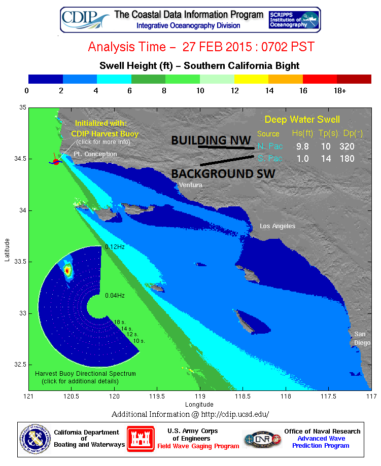
Had a fun week of small surf and nice weather. That is the same case today with a small SW in the water along with a building NW swell from a storm moving down the coast. Clouds and SE winds are increasing as the storm approaches tonight. That's the good news (which really isn't good news). The bad news is that the winds will increase more tonight (in the 15-25mph+ range) and as it does, the storm surf will pick up.
Look for small waves in the morning then jumbled head high+ waves in the afternoon. That lasts into Sunday. The water should be dirty also with all the runoff. Probably not what you want to hear on a Friday. On the bright side, water temps are still 62 degrees in the middle of winter!
Tides the next few days are around 4' at sunrise, down to 0' at lunch, and back up to 4' at sunset. Make sure to keep up to date on the waves/weather at Twitter/North County Surf. 

FORECAST:
The stormy conditions this weekend keep rolling into the first part of the work week as more wet weather arrives late Monday with windy conditions again and more NW windswell. Unfortunately, all this messy weather will mess up a good SW swell arriving late Monday into Tuesday also.
There was a good storm last week off Antarctica that was to give us head high+ sets in north county and overhead+ sets in the OC- but the impending storm on Monday night will blow it to bits. So we have that going for us.
Hopefully the weather cleans up the 2nd half of next week as there is more NW on the long term models for next weekend.

WEATHER:

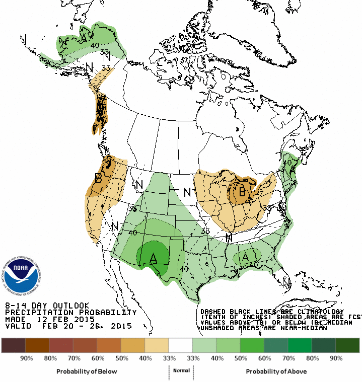
Looks like winter has finally returned to the month of February. After a fairly dry month, we got a little shot of showers last Sunday then nice weather the past few days. We currently have a storm moving down the California coast today and showers may arrive late tonight. The brunt of the storm though will start to build on Saturday with windy conditions tomorrow and the heavier showers late Saturday into Sunday. We may get a slight break on Monday morning but more showers should arrive during the day. Models are shifty after that so I can't tell you if it will be sunny the 2nd half of next week or if we'll get another storm next weekend. Until then, keep your eyes on the two upcoming storms the next 5 days as we should get close to an inch of rain at the coast and snow in the local mountains.

BEST BET:
I wouldn't say 'best', but Tuesday may be the call with the combo SW and NW swells- if you don't mind a little wind and rain...

NEWS OF THE WEEK:

Most of the talk about global warming has been centered around the climate and it’s impacts on land. But what about the waves? What about us surfers? We’re important too damnit! Well, the San Jose Mercury News reported recently that the surf spots you know and love may become obsolete in the future. But could new spots emerge? Read on…

On a summer day in 1885, three Hawaiian princes surfed at the mouth of the San Lorenzo River on crudely constructed boards made from coastal redwoods, bringing the sport to the North American mainland. Today their wave-riding successors consult satellite weather forecasts on smartphones before heading to Steamer Lane and Pleasure Point in Santa Cruz to don neoprene wetsuits. But the new century could bring the biggest transformation yet to surfing -- the waves themselves.  A rapidly changing global climate will likely affect prime surfing spots worldwide. And closer to home, the forecasts for Monterey Bay's famed big swells, while far from certain, are also far from good.  "It definitely worries me," said big-wave rider Jake Wormhoudt, who has already noticed changes in water temperature, weather and sand deposition throughout the 35 years he has surfed in Santa Cruz. One major source for California's surfing waves are open-ocean storms that send wave-generating swells toward the California coast. By 2100, these storms could shift, sending their swells on a course parallel to the coast rather than toward it. This change, coupled with dramatic sea-level rise, could eradicate today's surfing spots.  Scientists came to these conclusions using global climate models -- complex, computer-based crystal balls that use past conditions, current trends and greenhouse gas emission scenarios to predict our climate future.  Researchers recently adjusted these models to account for waves in a warming world, said coastal engineer Li Erikson, of the U.S. Geological Survey in Santa Cruz. Their findings surprised both scientists and surfers, who assumed a warmer and stormy future might push more waves to the coast. "Well, I thought so, too," Erikson said with a laugh. But, she explained, storms on land do not necessarily mean higher waves along the coast. Prime surfing corridors, she and other scientists explain, arise through a perfectly timed combination of deep-ocean swells, local winds and storm fronts -- all tossed in just the right direction against offshore shelves to push up the perfect wave. Climate change may simply upset this equilibrium.  "We'll roll with it," mused Pete Ogilvie, a Monterey Bay surfer for more than three decades who sums up what many see as the inevitability of change with a laid-back Surf City vibe. Changes to the surf can come in several forms. With the ocean warming and polar ice caps melting, sea levels are expected to rise along the Northern California coast between 1½ and 6 feet by the end of the century, which will change when, where and how waves break against the coast. "As we increase sea level ... those same size waves won't break over those nice bedrock ridges in the same spots that they used to," said Curt Storlazzi, a research geologist and oceanographer, also with the USGS office in Santa Cruz. "They're going to break much closer to shore."
Some Monterey Bay communities have erected barriers to protect homes and infrastructure from rising seas. In these areas, rising sea levels will eliminate low-tide surfing spots but the barriers would prevent new low-tide spots from opening up, said David Field, an oceanographer with Hawaii Pacific University who grew up surfing in the Monterey Bay. John Dee, who has been surfing in and around the bay for 20 years, is concerned about losing the area's low-tide corridors. "If there's a 3-foot tide, everyone's out here," he said recently as he headed out to Steamer Lane. "If there's a 5-foot tide, nobody's out here." These barriers may also contribute to beach erosion, cutting off access to surfing spots. Even though climate models predict larger storms and waves on the high seas, the North Pacific swell -- which generates many of the Monterey Bay's major winter waves -- is expected to shift. "As the temperature rises, especially in the Arctic, the big winter storms are moving farther north," Storlazzi said. "So areas along California are going to become less impacted from waves. "That's a bummer for local surfers, since many of the bay's best waves come from North Pacific swells. There's also a wild card in wave prediction. It's called El Niño, which is nearly impossible to forecast over the long term. El Niño conditions bring warm and high waters to the Pacific coast, rolling out a red carpet for strong storms, waves and winds to slam California directly from the southwest. That could improve surf conditions to the Monterey Bay, at least temporarily.  "They hammer the shoreline," Storlazzi said. "But they're the biggest and best waves." If the predictions come true and the Monterey Bay closes the 21st century with poor surfing waves, scientists say the shifting climate and rising seas could create better surfing conditions along other seawall-free stretches of the California coastline -- but there are too many variables to pinpoint where. This mixed and uncertain future may leave some surfers and their supporters grasping for certainty. But others are taking a sage-like perspective. Surfing "is a very experiential or 'now' activity," said surfer Ogilvie. "When waves die in one spot and pick up in another, you move to that spot."

BEST OF THE BLOG:

There's one thing north county is not short of- it's surf spots. Oh- and Mexican restaurants. And well, now grocery stores. Meet the latest addition to the proliferation of markets in the North County Surf Blog below!

PIC OF THE WEEK:

Ever wondered what California looked like before the Starbucks, Chipotles, and grocery stores? This is the real reason the Spaniards built all those missions along the California coast.

Keep Surfing,

Michael W. Glenn
Excellence Personified
Travolta's Wingman
Going Streaking At Snapper Tomorrow

Thursday, February 26, 2015

North County New Business News: Heard of Haggen?


There's two things I'm amazed at when it comes to variety in North County:

1. The amount of different surf spots we have- from point breaks to beach breaks, to reefs, and everything in between.
2. The amount of different retail stores we have. In just Encinitas alone we have eclectic independent stores like Surfy Surfy, La Especial Norte, and Besta Wan among others, to the 'brand name stores' like Home Depot, Target, and Chipotle among others.

Whatever you're looking for, it's a stones throw away. Grocery stores are no exception to the rule. Along with small independents like Seaside Market, Just Peachy, and our farmer's markets, we have our share of Whole Foods, Vons, Smart and Final, and others. Now add small Pacific Northwest grocery chain Haggen. The San Diego Union Tribune and San Diego Business journal reported recently that small market chain Haggen (how small? Just 18 stores to be exact) is exploding overnight with the recently acquired 146 stores in five states, including 25 in San Diego County, as part of a government-required divestment brought about by the pending merger of Safeway (which owns Vons also) and Albertsons, announced earlier this year.

After the close of the transaction in early 2015, Haggen will convert all of the acquired Albertsons and Safeway/Vons stores to the Haggen banner in phases during the first half of the year. The deal includes supermarkets in California, Oregon, Washington, Nevada and Arizona, including these local stores:
  • San Diego: Albertsons – 422 Washington St., 2235 University Ave., 730 Turquoise St., 5950 Balboa Ave., 10633 Tierra Santa Blvd., 10740 Westview Pkwy., 12475 Rancho Bernardo Road, 14340 Penasquitos Drive, 7895 Highland Village Place, 350 W. San Ysidro Blvd.
  • Chula Vista: Vons – 505 Telegraph Canyon Road, 360 East H St., 870 Third Ave.
  • La Mesa: Vons – 3681 Avocado Ave, 5630 Lake Murray Blvd.
  • Carlsbad: Albertsons – 955 Carlsbad Village Drive, 7660 El Camino Real.
  • Del Mar: Albertsons – 2707 Via De La Valle.
  • El Cajon: Vons – 2800 Fletcher Pkwy., 13439 Camino Canada; Albertsons – 1608 Broadway St.
  • Poway: Albertsons -- 14837 Pomerado Road.
  • Santee: Albertsons – 9870 Magnolia Ave.
  • San Marcos: Vons – 671 Rancho Santa Fe.
  • Coronado: Albertsons – 150 B Ave.
 
If you'll notice, this includes the looooooooong vacant Vons at 7660 El Camino Real and La Costa Avenue (has it been a decade)? So what is Haggen all about? CEO Bill Shaner describes it as "somewhere between a Vons and Whole Foods." The 146 store acquisition is an 811 percent expansion practically overnight. Grocery analyst and Supermarket Guru Phil Lempert in Santa Monica says the purchase is part of a national shift away from larger chain stores to more independently run grocers that can better meet the needs of local communities. A growing number of smaller chains like Haggen offer the wide selection of big chains, along with the fresh, local and gourmet selection of stores like Whole Foods at lower prices.

"Because they are independent, they're much closer to their consumers and are able to move much more quickly on different trends," Lempert said. The growing demand for fresh and local foods are two of the most important consumer trends for grocers, he said, and Haggen sources a significant amount of its food from local farmers and producers.

"There are certain stores that can put up posters showing Farmer Bob, but that doesn’t mean the apples under the poster are from Farmer Bob," Lempert said. "We’re in a much more transparent and yearning era where we want to know everything about where our food comes from." Haggen's stores in the Northwest also carry bulk foods and a wide selection of local beer.

"Variety is one of our strong points," Shaner said. "We’re going to carry pretty much everything that consumers are used to seeing in a full-line grocery store, plus we’re going to add some things they’re not used to seeing there and usually and have to go to another store to buy."

While some analysts say the purchase, with an estimated value of $400 million, is a positive move for Haggen, others aren't so sure it will work in the chain's favor. "I believe there's a dark side to this," said grocery analyst David J. Livingston, founder of supermarket research firm DJL Research in Milwaukee. Livingston pointed out that it's in Safeway-Albertsons' best interests to divest their stores not to the highest bidder, but to the weakest. "If I'm Safeway-Albertsons, I do not want to sell these stores to anybody who's very successful," he said. "Haggen has been struggling over the last few years. So if you had to sell some stores off, who would you rather sell them to: Kroger, which owns Ralphs, or a company that might not do very well and ends up closing stores so you have less competition?"

Shaner said that although Haggen did struggle for a few years during the Great Recession, it is doing well now under the leadership of private equity firm Comvest Partners. Every food retailer suffered through the recession, Lempert said, because food prices went up and grocers, reluctant to pass the increases on to their customers, absorbed "probably a little too much of that cost." Haggen right now is healthy, Shaner said, and poised to grow. And the divestitures from Safeway and Albertsons were "the opportunity of a lifetime." This expansion means not only a bigger brand footprint, he said, but also the promise of economies of scale and better buying power. That means a lower cost of goods, which in theory the supermarket company will then pass on to its consumers.

Shaner, a former executive for both Save-A-Lot and Supervalu grocery companies, was hired to help Haggen navigate the expansion. Haggen has a solid management team and infrastructure, he said. It also has a robust technology backbone thanks to a relationship with Supervalu, and a supply partnership with wholesale grocery cooperative Unified Grocers. "Frankly, those are the three reasons we will be able to accomplish this," Shaner said. It also helps that Haggen's newly acquired stores will come with managers and employees already intact; all Haggen will have to do is swap out the inventory and change the look and feel.

Livingston, though, is skeptical that Haggen will be able to scale up its operation without significant growing pains. "I think they’ve got a big uphill battle because they’ve bitten off more than they can chew," he said. Lempert is more optimistic, and expects Haggen to convert its new stores slowly and deliberately. He also expects to see some good talent from the grocery business migrate to Haggen. "They're not a stupid company," he said. "There's no way they would have been able to get the financing to pull this off if people didn't think they could."

Wednesday, February 25, 2015

Surf Check


Got some fun little waves out there today from a leftover NW and some really leftover SW (sounds like a Thanksgiving dinner that's been sitting in the fridge for a week). Waist high is the norm with maybe a chest high set if you're lucky.
Shouldn't sound ungrateful- heck this would be all-time for Florida today- but it feels like a letdown after all the good surf we've had in February.
Water temps are still 5-6 degrees warmer than normal at 62 degrees and tides are pretty mellow the next few days at 3' around sunrise, dropping to 0' before lunch, and up to 3' again at sunset.
We've got 1 more day of nice weather before the fog returns Friday in anticipation of our next weather system. Speaking of rain, I was surprised how much rain we got this past weekend from that 'weak' storm. I expected to get just a couple showers but it turned out to be a quarter inch. Crank up the El Nino hype machine again! Just kidding, but it was a welcome drop in the bucket and we are due for some more wet weather this weekend. Models show the winds picking up late Friday, showers starting on Saturday, and the brunt of the storm arriving Saturday evening/Sunday morning. We should get around 3/4" of rain with this along with gusts to 30mph along the coast. We get a slight break on Monday then the next storm arrives on Tuesday.
So before I get ahead of myself with all this rain talk, let's discuss the surf first and back into the weather scenarios and see how it will impact our upcoming week of waves. First up is a small storm that took shape off Antarctica last week that will send us chest high SW tomorrow and slightly better waves for the OC. That holds into Friday. Then the storm arrives Saturday, the S winds pick up, and we get messy head high+ surf the majority of the weekend.
As mentioned in my report on the weather, we get a slight break on Monday before another storm is forecasted to arrive on Tuesday. And us luck would have it, we have a BIG storm brewing off Antarctica today that is sending us our first real SW swell of 2015. The good news is that we'll have overhead sets here starting Tuesday and rolling into Wednesday; the OC will see bigger sets. But that damn rain/wind that is forecasted on Tuesday will screw everything up. I'm hope that either:

A. The models are wrong about the rain and high pressure sets up shop after this weekend's storm
B. The rain does arrive, but maybe it won't show up until late Tuesday so at least Tuesday morning will be rideable

And because of the all the storm activity in the northern hemisphere, we should have a shot of NW ground/windswell off and on all next week. Which is good because all that NW would make the big SW swell peaky next week- but that won't matter if it's stormy/windy/rainy!

After the waves/weather run their course next week, models don't show much in the way of SW/NW late in the week but it's still early but I'm at least hoping the weather will clean up by next weekend...


Thursday, February 19, 2015

THE Surf Report


Having fun yet?

SURF:
Don't you love it when we have fun surf for weeks on end? Makes work so much more bearable.
No exception this past week as we had fun surf last weekend (and great weather AGAIN) as well as fun surf this morning with low clouds. Tomorrow we have smaller leftover NW swell with chest high sets and more overcast conditions.
We had a small storm off Antarctica last weekend that will send some waist high+ SW swell our way late tomorrow into Sunday with chest high sets in the OC. If that doesn't excite you, we also have a small NW windswell showing up this weekend too. The NW+SW should make the beachbreaks peaky with waist to chest high+ waves if you play the tides right.
Speaking of the tides, we have 2' tides at sunrise, up to 6' mid-morning, down to -1' late afternoon, and up to just 0' at sunset. Water temps are still warmer than usual due to the slight El Nino and lack of storms (which would usually cause cold upwelling). So we're left with 64 degree water temps on the Torrey Pines buoy this evening. Break out the boardies! Make sure to keep up to date on the waves/weather at Twitter/North County Surf.

FORECAST:

After a fun weekend of small but fun combo surf, we get another pulse of NW groundswell for more waist to chest high waves late Monday into Tuesday.


On it's heels is more combo swell for late in the work week- a chest high NW and a chest high SW for shoulder high sets when both swells coincide.
Models also show a good storm taking shape off Antarctica next week which should give us head high sets from the SW the 1st week of March. Spring is almost here, right? I guess it's time for SW swells to start taking over.

WEATHER:

Looks like our summer weather is over for the time being. Unfortunately we don't have winter type weather either on the horizon. Look for the clouds to thicken up this weekend with a chance of drizzle or light showers late Saturday into Monday morning. We get a break in the weather early in the work week with more sun and temps back to 70 but then the clouds come back the 2nd half of next week. What does all of this mean? Mild weather with off and on clouds and no rain.

BEST BET:
Little swells off and on the next 10 days but late next week looks fun with the combo swells.

NEWS OF THE WEEK:

To continue on the rain theme from last week's THE Surf Report (or the lack of rain I should say), our snowpack in the Sierras isn't doing much better. It started off with a bang in December, then January limped in, and February looks like roadkill at this point. Most locations in northern California are reporting just 20% of normal snowpack this time of year. And if the season ended today, we'd just be at 15% capacity. Not enough to keep our lawns green down here or those swimming pools full this summer. So is this a sign of things to come?

Scientists have bad news for West Coasters in the grips of the worst drought in decades: The worst is yet to come. The record-shattering drought currently gripping California is NOTHING compared to the "mega-drought" that's expected to envelop the Southwest and Great Plains over the next 35 years, NASA revealed Thursday. The full study, ominously named "Unprecedented 21st century drought risk in the American Southwest and Central Plains," was published in Science Advances. The study, compiled by scientists from the space agency, Cornell University and Columbia University, predicts an 80% chance that the Great Plains and the American Southwest will endure a major weather shift beginning in 2050, which could spark massive wildfires and water shortages if the current pace of climate change continues.  Most alarming: The forecasted drought accompanying the weather shift could be of a severity not seen within the past 1,000 years. "We really need to start thinking in longer-term horizons about how we're going to manage it," said study coauthor Toby R. Ault, per the Washington Post. "This is a slow-moving natural hazard that humans are used to dealing with and used to managing." A mega-drought, which is a drought that lasts for several decades instead of the usual three years, causes ecological and agricultural damage on a planetary scale. "I was honestly surprised at just how dry the future is likely to be," Ault said at a press conference, according to Business Insider. "I look at these future mega-droughts like a slow-moving natural disaster. We have to put mega-droughts into the same category as other natural disasters that can be dealt with through risk management.” How did they figure this out?  Scientists studied past droughts using tree rings to determine how much rain fell hundreds (and thousands) of years ago. They then ran that data through 17 computer models of potential future temperatures across North America, which then predicted this bleak outlook. "Natural droughts like the 1930s Dust Bowl and the current drought in the Southwest have historically lasted maybe a decade or a little less," said Ben Cook, a climate scientist at NASA's Goddard Institute for Space Studies, according to Business Insider. "What these results are saying is we're going to get a drought similar to those events, but it is probably going to last at least 30 to 35 years."  This could change. The predictions are dire, but not exact. Weather patterns could change directions, global warming could be mitigated and even just one El Niño out West could disrupt a season of drought in the entire region. Still, a drought of some sort is certain. "We are the first to do this kind of quantitative comparison between the projections and the distant past, and the story is a bit bleak," said Jason Smerdon, another of the study's authors and a climate scientist from Columbia University, according to Business Insider. "Even when selecting for the worst mega-drought-dominated period, the 21st century projections make the mega-droughts seem like quaint walks through the Garden of Eden." Cold and soggy Seattle is looking pretty good right about now. Let the Chargers go to L.A.- I'm a Seahawks fan all of a sudden.

PIC OF THE WEEK:

Pop quiz! The guy in the picture with his arms up is:
A. Mindsurfing that wave and touching the roof of the barrel.
B. Got his arms in the air like he just don't care.
C. Thinks he's getting robbed because he only brought a 5'8" twin fin with him.

And the correct answer is:
D. Doing what any stoked surfer would do and screaming his lungs off.

Keep Surfing,

Michael W. Glenn
Taking the Lead On This One
Got Picked By NASA To Go To Mars!
Can Turn A 3 Into A 9

Tuesday, February 17, 2015

Surf Check


Not to sound spoiled or anything, but it looks bad out there today. I know, I know, I should be grateful for the last month of surf and amazing weather- but I want more damnit! Not going to find it today unfortunately.
Great surf and weather last Tuesday and again over the weekend has been replaced by overcast skies, temps in the high 60's, and a flat ocean. At least the water temps are 5-6 degrees warmer than usual at 62 degrees and I can keep the 4/3 fullsuit locked away in the closet.
Whatever tiny NW/SW may be out there today is also getting played by the extreme 8' tide swings. We've got a 6.5' tide right after sunrise, bottoming out to -1.5' mid afternoon, and it only rises to 1' at sunset.

So if the waves are flat today, what's the weather at least doing? Models have high pressure building slightly tomorrow for a little less low clouds/fog and temps rebounding to the low 70's. Then we've got some clouds headed our way again late Thursday into the weekend. That may actually give us a shot of sprinkles. Bam! Winter has returned to southern California. Take that East Coast. Nothing major of course but the clouds will stick around most of the weekend and the bikinis will be vacant from the beaches.
The good news is that the slight warm up tomorrow will coincide with more WNW swell on Wednesday. Look for shoulder high waves in town again and head high waves in SD. On it's heels is another storm taking shape today in the Pacific. It looks impressive on the models but it's forecasted to die off before it makes a real push towards our coastline. Look for chest high waves though by Saturday and shoulder high sets in SD.
And if you don't mind the clouds this weekend and a fun little WNW, then the forecasted chest high SW swell arriving late Friday into Saturday will make up for the dreary conditions. Should be lots of fun waves to go around even though it will be cool. Charts also show some storms forming off Antarctica late next week which would give us good SW towards the end of the month. Nothing's concrete yet but you'll be the first to know.


Thursday, February 12, 2015

THE Surf Report


So far so good.

SURF:
Been a good winter so far, I must confess. As you know, I was hoping for a bombing El Nino winter and it's not really happening- but plenty of fun waves and Santa Ana winds are tempering my disappointment.
We had a fun week of swell and great weather again and we've got more of the same this weekend. New WNW is filling in tonight and we'll have shoulder high waves tomorrow and great weather- again. Tomorrow looks to be the last off the 'Santa Ana' offshore wind event, but Saturday and Sunday will still have great conditions and holding WNW swell.
Water is holding at 60 degrees and tides the next few days are 4' at sunrise, down to 0' at lunch, and up to 3' at sunset. Make sure to keep up to date on the waves/weather at Twitter/North County Surf

FORECAST:

Looking small to start the workweek but models are showing more NW showing up late next week for shoulder high sets again. And on it's heels is more NW early in the week of February 20th. The southern hemisphere is starting to come alive but none of the storms are aimed our way. Hopefully the models are wrong and we'll get SW towards the 3rd week of the month.

WEATHER:

Another great week of San Diego winter weather. Tomorrow and Saturday will be no different with the last of the 'offshores' on Friday and calmer winds on Saturday. We've got a transition day on Sunday as the low clouds start to return but we've still got nice weather in the low 70's that lasts through Wednesday. And as luck would have it, models show high pressure setting up again the 2nd half of next week for more sunny skies and temps in the high 70's again.

BEST BET:
Tomorrow's the day with fun WNW in the water and great weather. Or try your luck next Friday as models show more WNW arriving AND great weather again. Groundhog Day!

NEWS OF THE WEEK:

I'm pretty much ready to write off El Nino except the 'experts' still stay there's a 50% chance of big storms headed our way the next couple of months. But that doesn't do us any good in the near future as we haven't had a real storm in over a month and there's nothing on the charts for at least the next 7 days. So where do we stand on our rainfall so far this season? Here's the latest:

  • Newport Beach: 4.52" of rain so far. Only 69% of normal.
  • Oceanside: 4.95" of rain so far. Only 78% of normal.
  • San Diego: 5.32" of rain so far. 117% of normal.

Considering we're almost a month away from spring, storms will start to become fewer and farther between- with our without the El Nino. Normal rainfall for the season is around 10" in SD and 13" in Newport; as you can see, we've only had about 5" so far- and getting closer to the drier months of spring isn't helping.

PIC OF THE WEEK:


If Sir-Mix-A-Lot were a surfer, he'd be a local at this place. I like big barrels and I can not lie!

Keep Surfing,

Michael W. Glenn
Miracle Worker
Enshrined at Canton
Mount Rushmore of Surfing: Duke, Slater, Curren and Glenn

Thursday, February 5, 2015

THE Surf Report


Something for everyone.

SURF:

Had another fun week of surf and fairly mild weather- life is good in San Diego. Today we had some leftover chest high sets from the NW and tomorrow morning is looking pretty small, but we've got a couple swells lined up for the weekend, and if you're lucky, you may get a couple sets before sundown tomorrow night.
We've got 2 swells hitting their stride on Saturday- first is a SW swell that originated off Antarctica last week and will give us chest high waves in north county and shoulder high waves in the OC.
On it's heels is a similar sized NW groundswell that formed from a storm a few days go off the Aleutians. When both swells merge on the sets, look for head high peaks most everywhere. That lasts into Sunday. Should be a fun weekend of surf.
Water is holding at 60 degrees and tides the next few days are 2' at sunrise, up to 5' mid-morning, and down to 0' around sunset. Make sure to keep up to date on the waves/weather at Twitter/North County Surf.

FORECAST:

After the weekend combo swell, we've got a bigger NW headed our way for Tuesday with overhead sets in north county and a few feet overhead in SD.
Right behind it is more SW for the middle of the week- so the OC won't be left out of the fun.
AND THEN... we've got more head high NW late in the week as well as chance of more SW towards the 20th. AND... our weather should be fantastic. It's a good time to be a surfer.

WEATHER:

Pesky fog has been inhibiting the early morning dawn patrols and that may stick around this weekend as a strong storm will rip through the Pacific Northwest this weekend and thicken up our clouds down here. Once that moves through this weekend, we've got mild weather to start the week and temps in the mid-60's. High pressure sets up behind it towards Wednesday and we get warmer temps in the mid-70's and plenty of sun. And no rain unfortunately for us in the foreseeable future!

BEST BET:
Plenty of swell this weekend BUT... cool temps and low clouds. Next week looks solid with plenty of SW/NW swells and better weather. Can't be greedy though- any of it is better than working!

NEWS OF THE WEEK:

As a surfer, there are 3 things that scare us: tsunamis, polluted water, and Great Whites. And if they were alive today, you could add the Megalodon to top of the list: the prehistoric monster shark.
The Megalodon , ("giant tooth") was one of the biggest, ferocious prehistoric animal ever lived on Earth. Megalodon ruled the temperate and warm waters of all the oceans between 25 and 1.5 million years ago. They hunted in a variety of environments including coastal zones, lagoons, and deep water. And if you thought 25’ Great White sharks were big, the Megalodon grew to twice that size (estimated at 50-60 feet. Just think how big a 60’ day at Mavericks, Jaws, or Cortes Bank is- now you’ll start to understand just how gargantuan these behemoths were). And if you think it’s scary to see a Great White feasting on a seal or surfer for that matter, the Megalodon had an appetite for something larger- like whales and other sharks. Fossils of Megalodon teeth have been found on every continent with the exception of Antarctica and have even been found in the Mariana trench. Research has found that Megalodon rammed and tried to break the bones of smaller whales, injuring them before consuming them. Another tactic would be to bite off the flippers and tails of larger whales, immobilizing them before going in for the kill. Megalodon is regarded as one of the largest and most powerful predators in vertebrate history. Megalodon likely had a profound impact on structuring of the marine communities. Fossil remains indicate that this giant shark reached a total length of more than 50', and also affirm that it had a cosmopolitan distribution. Scientists suggest that Megalodon looked like a stockier version of the great white shark. Because sharks are made of cartilage and not bone, it is a common misconception that teeth are the only parts of the shark that fossilize but the fact is that fossilized cartilage are harder to find. Shark teeth are the most common type of fossil for a number of reasons and one of it is that shark teeth like most teeth are made of dentin, a hard calcified tissue harder and denser than bone that does not easily decompose.
The most common fossils of  Megalodon are its teeth : triangular shape, robust structure, large size, fine serrations and visible v-shaped neck. The teeth of Megalodon can measure over 7.1 and are the largest in size of any known shark species. The Megalodon had a total of about 276 teeth in its jaws, spanning 5 rows, also researches indicate that it had one of the most powerful bites in history. A 50’ long Megalodon was capable of exerting a bite force estimated at 24,395 lbs. of force and its bite force is over 10 times greater than that of a the more famous T. Rex.

Interesting Facts
-Teeth over 7 inch long
-Was declared as the most powerful bite of any creature that ever lived 
-Huge dimensions : around 50-60’ and up to 50 tons in weight

Let's just hope scientists don't figure out how to clone these things from DNA and let them loose into the wild again. Jurassic Park was just a movie, right?

PIC OF THE WEEK:

Simply put: PDF (Pretty Darn Fun). 

Keep Surfing,

Michael W. Glenn
Out of This World
Just Opened A 1-Hour Photo Franchise
Learned to Air From Freida Zamba