Thursday, March 25, 2021

THE Surf Report


SURF:
You know that old children's tale from the sea. It's like you're dreamin' about Gorgonzola cheese when it's clearly Brie time, baby. Step into my office! What's that have to do about the surf the past week? Not sure.


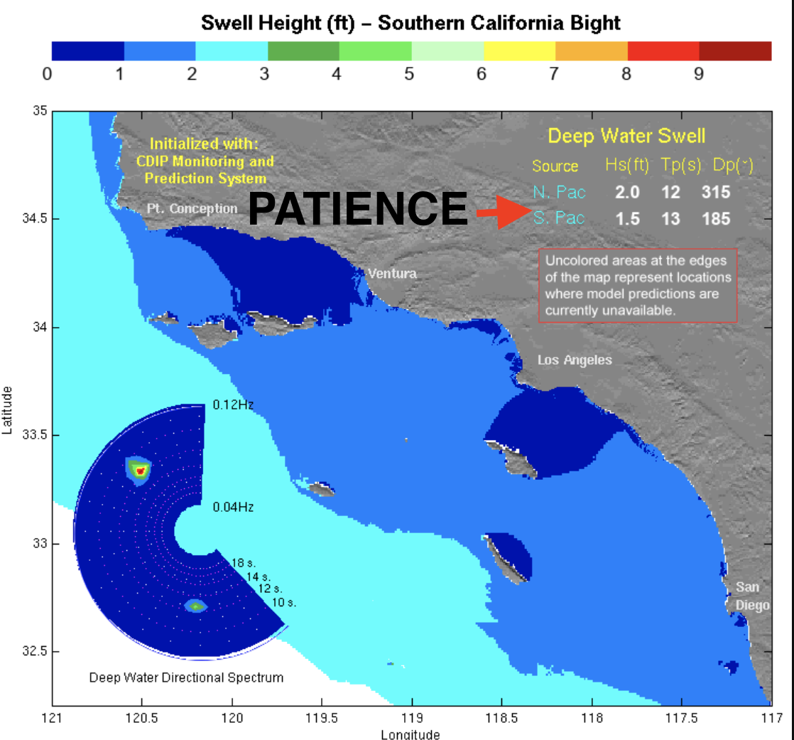
All I know is that we had a mixed bag with weak cold fronts moving by the N and leaving us with NW winds and FREEZING water temps. Wednesday/Thursday were cleaner but the NW and SW swells were on their way out. Today? Another cold front is passing by and whatever small surf is out there was blown to bits. 


Good news is that Friday looks to be clean and we've got a bump of NW windswell in the water for chest high surf with smaller SW underneath. For Saturday & Sunday, the NW will be gone, but we'll have leftover waist high+ SW and chest high sets as you move towards the OC. And here's the tides, sun, and water temps: 
  • Sunrise and sunset:
    • 6:43 AM sunrise  
    • 7:05 PM sunset  
  • Water temps are a chilly 57. 
  • And the tides are on a racetrack this weekend:
    • 4' at sunrise
    • 6' mid-morning
    • -0.5' mid-afternoon
    • and back to 4' at sunset
FORECAST:

Next week summer starts to take hold while winter fades away. 


Monday sees leftover waist high+ SW swell then another weak cold front moves by the N for chest high windswell on Tuesday. 


Wednesday is clean again as the NW fades and new small but fun SW builds. Look for waist high+ surf with chest high sets in far N County SD. 


After that, the SW gets a reinforcement from a good storm off Antarctica and we'll see chest high+ SW around the 2nd of April. And beyond that... the N and S Pacific look to take a breather so get it while you can.

WEATHER:


If you loved this week, you're gonna love next week! As mentioned above, the weak cold front today will exit tonight for sunny skies tomorrow and temps in the mid-60's on Friday. Saturday hits 70 and Sunday the mid-70's at the beaches! Then another weak front moves through late Monday into Tuesday for cooler/breezy conditions again, then we get a warm up the 2nd half of next week. If anything changes between now and then, make sure to check North County Surf on Twitter!

BEST BET:
Friday with clean conditions and combo swell. Or late next week with great conditions and a fun SW swell. 

NEWS OF THE WEEK:


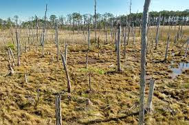
Kind of cool looking but not really all that cool at the same time, along the mid-Atlantic and southern New England coast, an eerie sight dots the changing landscape. Rising sea levels turn thriving green vistas of hardwood and evergreen trees into "ghost forests," dried-up terrains filled with gnarled, dead, and dying timber. Under climate change, these could become an even more common sight, according to a new report published by Rutgers University. Here's the Smithsonian to explain:

Ghost forests are landscapes that form when saltwater begins to flood woodland areas that contain freshwater-dependent trees. The water high in salinity slowly poisons trees, and as they die, all that is left behind are ghostly gray trunks that resemble toothpicks. The trunks can last decades in this dried-up barren state.

Researchers at Rutgers University, along with the United States Department of Agriculture, found that coastal woodland forests ranging from Virginia through Massachusetts are dying as a result of heavy rain, saltwater surges, and flooding from rising sea levels.

The rising salt water not only kills trees but leaves soil unhealthy and forests uninhabitable for new growth. This report is alarming as coastal forests are habitats for many rare plants and wildlife, such as the threatened swamp pink plant.

                             
Not only are the ghost forests expanding because of climate change, they could also be making hostile conditions worse through a feedback loop. Forests along the East Coast are riddled with evergreen trees that absorb carbon dioxide almost year-round, making them crucial carbon sinks that can lower carbon dioxide concentrations from the atmosphere.

With fewer evergreen trees, less carbon is removed from the air.
“One ecological benefit of healthy coastal forests is the sequestration and storage of carbon both aboveground and in soils. As coastal forests transition to marsh, we lose aboveground carbon. Some of that is released into the atmosphere, and some shifts to other carbon pools,” Lindsey Smart, a ghost forest expert at the North Carolina State University.

To mitigate ghost forests, coastal forests need protection from development, and proper planning and collaboration with landowners must be established, according to the Rutgers report. Solutions the researchers suggest include creating living shorelines by planting trees to slow erosion, depositing sediments to help marshes move to higher elevation as sea levels rise, and planting forest vegetation that can tolerate changes in soil.

“This study adds to the growing evidence that this is not a localized phenomenon, given other reports up and down the east coast,” says Smart. “While the rate and extent varies based on local site characteristics, it’s clear that sea-level rise and the synergistic pressures between sea-level rise and land use modification...are changing our coasts, impacting our coastal forests.”

PIC OF THE WEEK:


A gift to my goofyfoot friends. Here's what it would be like to surf Swami's if it was a left. Or Bells. Or Coxos...

Keep Surfing, 
Michael W. Glenn
Nonchalant
Masked Singer
So Amped When I Surf That I Recharge My Jet Surf

Thursday, March 18, 2021

THE Surf Report- Early Edition


SURF:


Bit of a mess earlier in the week due to a late winter storm but that was replaced by cleaner weather and a small SW swell yesterday. Today we just had leftover knee high+ SW swell and not much else. 


For the weekend, we've got a storm moving by to the N and as it does, look for our clouds to increase, the sea breeze to be a little stronger Saturday and the NW ground/windswell will pick up. Friday starts off slow then by the afternoon we should see some chest high+ sets. Saturday may be a little bumpy but we could see shoulder high+ waves and bigger towards SD. On Sunday, the NW holds and we've got an early season SW filling in too. Hopefully the weather will be clean by then. All in all, some increasing surf this weekend from the NW/SW and questionable conditions. And here's the tides, sun, and water temps: 
  • Sunrise and sunset:
    • 6:52 AM sunrise  
    • 7:00 PM sunset  
  • Water temps are only 58 due to all the NW wind lately. Once spring hits and the S 'fog' wind starts blowing, our water temps will consistently be above 60 (which typically doesn't happen for another month).
  • And the tides this weekend aren't that impressive:
    • 2' at sunrise
    • 1' mid-morning
    • 3' at sunset
FORECAST:
Interesting week next week as we've got off and on weak cold fronts moving by the N so the sea breeze will be mellow to breezy depending on the day. 


As far as the swell goes, the SW that was building on Sunday will peak on Tuesday/Wednesday for chest high+ surf in N County SD and slightly better in the OC. Monday will be clean and then breezy on Tuesday. Wednesday looks to be clean again. Late next week we could see more SW arrive BUT... breezy conditions may arrive again due to another weak cold front. The bonus to all these weak cold fronts? Pretty much waist high+ NW windswell all next week to break up the SW swell. 

WEATHER:


As mentioned above, looks like we've got weak cold fronts moving by to the N the next 7+ days and not much precipitation. Look for a little more clouds Friday/Saturday, breezy conditions, and cool temps. Sunday/Monday look to be cool again but sunny, then another weak front on Tuesday. Wednesday/Thursday? Nice and cool. And next weekend, maybe another weak front for more clouds and a blown out afternoon. If anything changes between now and then, make sure to check out Twitter/North County Surf!

BEST BET:
Sunday with combo swell and potentially clean conditions. Or Wednesday with clean conditions again and fun SW swell. 

NEWS OF THE WEEK:


Remember all those kelp beds in North County San Diego that kept our surf glassy all day long? Neither do I. Seems like eons ago. So where'd the go? Seems as though Northern California has the same problem. I'll let the San Francisco Chronicle explain:

The kelp forest that only eight years ago formed a leafy ocean canopy along the Northern California coast has almost completely disappeared, and scientists who study kelp and the species that depend on it are worried about its inability to bounce back.

A new study from UC Santa Cruz found that the kelp forest on the Sonoma and Mendocino coast has declined by an average of 95% since 2013. It analyzed satellite imagery going back to 1985 to investigate how a series of factors led to the kelp forest’s abrupt decline, including an explosion in the population of purple sea urchin, which eats it, and two marine heat waves. The research shows the unprecedented destruction was related to unusual ocean warming and that the kelp forest likely won’t recover any time soon, partly because removing the urchins is so difficult.

“They can actually survive under starvation conditions,” said Meredith McPherson, a graduate student at UC Santa Cruz’s Ocean Sciences department and coauthor of the study. “The impact has been that basically there is no kelp forest at all left, really.”


Bull kelp (Nereocystis luetkeana) usually thrives in the rocky coastal zones of Sonoma and Mendocino counties and creates a habitat for many types of fish and invertebrates, including abalone, sea urchin, jellyfish and sea snails. Its disappearance also has had impacts on local tourism and other businesses — the abalone fishery closed to recreational divers in 2018, and Mendocino County’s commercial red sea urchin fishery is almost completely shut down.

The two warm water events that helped cause the kelp forest’s decline include an El Niño and what was known as warm water “blob” that together lasted from 2014 to 2016. Around the same time, a wasting disease struck the sunflower sea star population, leaving the purple urchin without a predator.

Those urchins quickly took over, eating the remaining kelp and starving off two other species popular with divers and sushi lovers — red abalone and red urchin (purple urchin is not as commercially viable). What is left are called urchin barrens, rocky areas completely covered with the spiky purple invertebrates over hundreds of kilometers of the North Coast.

“What we’re seeing in Northern California is quite unprecedented in terms of its scale,” said Tristin McHugh, kelp project director at the Nature Conservancy’s California Oceans Program, which is developing pilot methods to remove purple sea urchins and restore kelp.

Though there was fear another warm water blob was forming last year off Alaska, water temperatures in the North Coast have returned to normal, McPherson said, and yet the bull kelp hasn’t recovered. Unlike other kelp native to California, it’s an annual species that dies off in winter, when it washes onto shore into piles that resemble long, green-brown hoses with bulbous tips. It normally returns each spring.

Scientists had already been monitoring the kelp forest’s decline for years with aerial photography and tidal data, but the new study was the first to use satellite imagery to more closely analyze changes in growth along with ocean temperature and nutrient levels. “We’re able to see kelp relatively easily from space using satellite,” McPherson said.

Bull kelp growth depends on cold upwellings in spring that bring nutrients to the surface, and those are reduced when water temperatures rise. Though previous El Niño events — a natural pattern that causes Pacific water temperatures to go up for a year or two — have also caused the kelp to decline, it has usually recovered.


What was different about 2014-16 was the purple urchin explosion and the addition of the warm water blob, which at its peak raised ocean temperatures by almost 7 degrees above average. While there’s some evidence that the blob was linked to climate change, what is more important is that marine heat waves are becoming more frequent and intense as global temperatures rise because of climate change, McPherson said.

Climate change, pollution and other factors are also blamed for the global decline of kelp forests over the past 20 years, but in California, it’s at its worst on the coast north of San Francisco. Monterey Bay and other parts of Central California have also lost kelp forest to urchin barrens, but those areas have a mix of bull kelp and giant kelp and also have sea otters that help prey on the urchins. In Southern California, where giant kelp is the main species, the forest has persisted better.

The most concerning part about the decline of the Sonoma-Mendocino kelp forest is that unless the sunflower sea star or another predator returns, the purple sea urchin shows no sign of budging.

“Usually some kind of physical disturbance or disease would wipe out the population,” McPherson said. “It could go on for decades and decades.”


The loss of their habitat to purple sea urchin is the reason the California Department of Fish and Wildlife in 2018 put a five-year pause on recreational fishing of red abalone, which usually brings recreational divers from all over California to the North Coast. As a result, the last dive shop in the area closed in Fort Bragg about a year ago.

Many out-of-work, professional red urchin divers have been hired in a state-sponsored program managed by the nonprofit Reef Check to remove purple urchin from the sea floor manually. It’s a slow process. In some cases, there are as many as 20 to 30 urchin per square meter of sea floor, and similar efforts in Norway, Japan and New Zealand have shown it’s necessary to get down to 2 per square meter for the kelp forest to recover, McHugh said.

PIC OF THE WEEK:


Australia or New Zealand? Looks a lot like Angourie Point but there's not trees on the point. Anyone from Down Under reading this that can shed light on the subject? Promise I won't tell anyone. Promise...

Keep Surfing, 
Michael W. Glenn
Superstar
My Bracket Is Still Perfect For The Next 12 Hours
Think I'm Going To Foil The Wedge Next Hurricane Swell

Thursday, March 11, 2021

THE Surf Report- Early Edition


SURF:


Week started off fun before our winter rain arrived (3 months too late). Today the low pressure system lingered while the NW did too for shoulder high sets and slightly bigger towards SD. For Friday, look for the NW to be best in the AM with chest high+ waves and then drop again Saturday/Sunday. At that point, we'll be down to waist high surf from background SW/NW. Weather should be nice though. And here's the tides, sun, and water temps: 
  • Sunrise and sunset:
    • 6:01 AM sunrise  
    • 5:55 PM sunset  
    • AND DON'T FORGET TO SET YOUR CLOCKS BACK ON SATURDAY NIGHT! Starting Sunday, sunrise and sunset will be...
      • 7:00 AM sunrise
      • 6:56 PM sunset
  • Water temps are hovering in the high 50's.
  • And the tides this weekend:
    • 1' at sunrise
    • 5.5' late morning
    • 0' at sunset
FORECAST:


We've got a storm passing by to the N on Monday and as it does, it will send some new NW down here.


Look for shoulder high sets Monday afternoon and a new fun S swell on Tuesday for head high surf. Winds may be iffy though to plan accordingly. 


Swells back off mid-week but charts show more fun shoulder high+ W swell next weekend. 


AND... right on schedule for the first week of spring (starting March 22nd), looks like we could have some shoulder high SW swell. In summary- nothing big on the horizon but fun. 

WEATHER:


Much needed rain fell this week for 3/4" to 1" along the coast and up to 2' of snow in the mountains. Elvis has since left the building and this weekend we have sunny skies and cool temps near 60. A weak front moves by to the N on Monday/Tuesday and we've got a touch more clouds and breezy conditions. After that, weak high pressure is forecasted to set up shop and we're back to great weather; as if you expected anything less in San Diego. If anything changes between now and then, make sure to check out Twitter/North County Surf

BEST BET:
Tuesday with combo swell (if the winds aren't problematic), next weekend with new W, or the 3rd week of March with fun SW!

NEWS OF THE WEEK:


If we weren't screwing up the planet enough already, Popular Science reported recently that humans are altering Earth’s tides, and not just through climate change; shipping is a surprisingly major driver. Yes, those big container ships. How? I'll let Pop Sci explain:

If you’d been standing in just the right Miami Beach parking garage in 2016, you would have been visited by an octopus, washed in on an especially high tide. In Boston, you might have needed to wade to work in the past year. Across the country, sunny day floods, which occur because of high tide, rather than storms, are becoming increasingly common—they’re the leading edge of sea level rise, as tides reach further and further into coastal cities.

But climate change is just one way that humans are driving sunny day flooding. New research, published Friday in the journal Science Advances, finds that coastal development has increased the intensity of the tides themselves. At 18 sites across the US, projects on coasts amplified the effects of sea level rise on local flooding, to the point that by 2019, a quarter of all nuisance flood days in those locations were related to local changes in tide.

The research builds on increasing recognition that humans can shape tides, says Thomas Wahl, an engineer at the University of Central Florida who studies coastlines and climate change, and is an author on the paper. “For a long time, oceanographers operated under the premise that tides are stationary, they’re driven by the relationship between the sun, moon, and Earth, and the system doesn’t change.”

But over the last few years, Wahl says that there’s been a growing body of research that shows that tides in bays, estuaries, and even along the open coastline can be reshaped by human hands.

That can happen in many different ways. Hard seawalls reflect high water, and land creation can influence currents in unpredictable ways. But “number one, of course, is dredging,” says Wahl. Most American ports rely on massive channels dug into the muddy bottoms of harbors to allow the passage of oceangoing ships.

Cargo ships have grown physically larger over the last 100 years, so shipping channels have too, changing the local tides. “We basically have marine highways that are going into our shallow water harbors,” says Stefan Talke, an environmental engineer at California Polytechnic University and another study author.

“If you dredge, you have deeper water,” says Wahl. “If you have deeper water, you have less friction, so the tidal waves can enter the system more quickly, and leave more quickly.” And when it rushes in faster, it can slosh up higher on land.


Still, knowing that humans can change tides doesn’t necessarily mean understanding how developments have played out along the American coastline. To get that information, Talke has been digging through federal records to understand how tides looked hundreds of years ago.

“The US government has been measuring tides since at least the 1840s,” Talke says. Surveying waterways was key to the country’s economic and colonial ambitions, which depended on the shipping industry. “They needed to make maps, they needed to know when high tide was.”

But many of the records, kept on long, well-preserved scrolls, have disappeared into the National Archives. (Some were destroyed entirely, including those for Charleston, South Carolina, which were stored in a customs house attic and eaten by “vermin,” Talke says.) Talke and his students have spent years digitizing what records they can find.

In half of the locations where long-term data was available, tidal gauges showed intensifying highs and lows over the last 100 years. The changes were more pronounced in cities located in slightly inland estuaries, where a dredge channel deepens the waterway most dramatically. Wilmington, North Carolina, which was flooded for almost a quarter of 2016, was particularly affected, though Philadelphia and New York City saw similar trends.

On their own, the more intense tides wouldn’t necessarily have led to increased flooding. But the higher overall oceans and more intense tides have compounded, leading to more days where water spills onto streets.

And because the research focused only on the 40 locations with a hundred years of tidal records, Wahl thinks the findings are only part of the picture. “There are probably many other places where the same thing is going on, but we don’t know, because we don’t have that same amount of data.”

A few inches of water might not be as catastrophic or deadly as a storm surge, Wahl says, but over time they can have bigger economic consequences. “At some point, it has an impact on infrastructure. People can’t go to work. Businesses can’t open.”
But understanding the role of infrastructure in high tides might help guide sea level adaptation. The Army Corps already uses data on catastrophic flooding risk when it evaluates new dredging projects, since it’s well-known that shipping channels can intensify storm surge during hurricanes. One such passage was implicated in the deadliest flooding of Hurricane Katrina.

But, Walsh says, “we haven’t really attempted to study how [shipping channels] could affect just the tide, and how that would affect nuisance flooding.”

This research, he says, provides the first steps towards asking those questions. “We may have to ask ourselves if we are aiming for bigger ships, or less flooding.”

PIC OF THE WEEK:


Next week as you know is St. Patrick's Day. People with (or without) Irish heritage will be celebrating in their own special way the patron saint of Ireland. Either by attending church, drinking green beer, attending a parade, setting a leprechaun trap, or partaking in a Shamrock Shake. Me personally, I'll be surfing this wave in Lahinch; in a green wetsuit of course. 

Keep Surfing, 

Michael W. Glenn
Never Been On Time Out
Saving Daylight Time For A Rainy Day
Know How To Ride A Surf/Wake/Skate/Snow/Skim/Body/Paddle Board. Switch.

Thursday, March 4, 2021

THE Surf Report- Early Early Edition


Dodging wind & weather.

SURF:


Great weather earlier this week- but not much swell- was replaced by rain, wind, and building swell today. Gotta be on your toes around here. 


For today, we have peaking NW this morning and building SW. Look for chest high+ combo swell and clean conditions. 


For Friday, the NW is gone but the SW is holding for more fun chest high waves and bigger towards the OC. 


The Aleutians have finally come back to life too and we've got more NW lining up for Saturday/Sunday in the shoulder high range. So it looks like the next few days will have fun surf in town. Here's the tide, sun, and water temps for you:
  • Sunrise and sunset:
    • 6:10 AM sunrise  
    • 5:50 PM sunset  
  • Water temps are hovering in the high 50's.
  • And tides this weekend are a big yawner:
    • 3' at sunrise
    • 0' mid-morning
    • 3' at sunset
FORECAST:
Next week looks to have another swell on the books BUT... the storm that generated it may be arriving on our shores at the same time too. 


Look for leftover but fun chest high NW on Monday then increasing WNW swell on Tuesday for shoulder high sets late. Should see head high+ surf on Wedneday and that lasts into Thursday morning. Just keep an eye on the conditions for late Tuesday into Thursday morning. There's also a chance of more NW next weekend- so it looks like we're back in the swing of things again. 

BEST BET: 
Thursday/Friday with decreasing NW & increasing SW. Or Saturday/Sunday with fun NW. Or... next Wednesday with new NW (if it's not stormy).

WEATHER:


Good to see some rain finally. I was starting to think that winter was summer and summer was winter around here. Most locations at the cost received 1/2" and inland locations 3/4". We even saw wind gusts of 80-70 mph in the local mountains. For today and Friday, we've got cool sunny skies before a weak cold front moves by to the N this weekend and kicks up the sea breeze down here. Monday looks to be cool and clear again then models hint at more showers towards Tuesday and mid-week. Which would be normal for this time of year in case you forgot. Make sure to check out Twitter/North County Surf if anything changes between now and then. 

NEWS OF THE WEEK: 


New research reveals Earth's major ocean currents are slowing down, and though the consequences will not seem immediate, there are real-world long term impacts for global weather patterns and sea levels. Here's a recent report from the Cable News Network:

The slowdown of ocean circulation is directly caused by warming global temperatures and has been predicted by climate scientists. "This has been predicted, basically, for decades that this circulation would weaken in response to global warming. And now we have the strongest evidence that this is already happening," said Stefan Rahmstorf  of Potsdam University who contributed to this research.

The Atlantic Meridional Overturning Circulation (AMOC) transports water across the planet's oceans, including the Atlantic, Pacific and Indian. The region contributing to the slowdown is the North Atlantic, according to the research. "The idea is that if this Atlantic overturning circulation breaks down all together, this will lead to a strong cooling around the northern Atlantic, especially into Europe, into the kind of coastal areas (of) Britain and Scandinavia. But that's only true if the overturning breaks down all together," Rahmstorf  said. In this part of the ocean, the Greenland ice sheets are melting, contributing to both a rise in sea levels and serving to reduce the speed of the circulation. "This indicates that the slowdown is likely not a natural change but the result of human influence. The AMOC has a profound influence on global climate, and particularly in North America and Europe, so this evidence of an ongoing weakening of the circulation is critical new evidence for the interpretation of future projections of regional and global climate," said Andrew Meijers, deputy science leader of polar oceans at British Antarctic Survey.


Ice melting in Greenland and the heavy rainfall over the North Atlantic induced by climate change has affected the salinity and density of the waters, Rahmstorf explained. "Both surface warming and the increased water cycle, increased rainfall and the ice melt are all a consequence of global warming" across parts of the North Atlantic Ocean, he said. As warm water currents move north, they typically turn back south as it gets cooler and heavier. Added freshwater from the melting ice is causing this turn to be slower because of reduced salinity. "This weakening also leads to cold in the northern Atlantic, but it's confined to the ocean. This cold blob, as we call it, is over the ocean, and it doesn't touch on land areas," said Rahmstorf. Current estimates show this weakening is moderate, at about 15% weaker compared to normal and based on data analyzed up from to 1,600 years ago.

One of the main impacts of the slowing ocean circulation is on sea levels, especially those of the US East Coast. "The northward surface flow of the AMOC leads to a deflection of water masses to the right, away from the US East Coast. This is due to Earth's rotation that diverts moving objects such as currents to the right in the Northern Hemisphere and to the left in the Southern Hemisphere. As the current slows down, this effect weakens and more water can pile up at the US East Coast, leading to an enhanced sea-level rise," said Levke Caesar, one of the authors of the report.

Sea-level rise is already happening due to factors like melting ice sheets and warming oceans. According to the National Oceanic and Atmospheric Administration (NOAA), water levels have risen by 8 to 9 inches on average within the past 140 years. The rate at which these waters are rising has also increased in recent years. "The pace of global sea-level rise more than doubled from 1.4 mm per year throughout most of the twentieth century to 3.6 mm per year from 2006-2015," said NOAA. A further slowdown of global ocean circulation, especially along the crucial Gulf Stream current off the eastern coastline of the US, could combine with the already accelerating sea-level rise to make major Northeastern cities even more vulnerable to flooding. 


Global weather patterns are critically linked with the ocean circulations and their transport of heat and nutrients around the planet. An increase in heat waves across Europe and stronger hurricanes closer to the US coastline because of warmer water drifting closer to the coast can be linked to the ocean circulation, Rahmstorf said. "The world's seven warmest years have all occurred since 2014, with 10 of the warmest years occurring since 2005," said NOAA. Heat waves are becoming more frequent already. The ocean and the currents also play a role in absorbing carbon dioxide, the most dominant greenhouse gas, from the atmosphere. The changing currents could decrease the amount of carbon being taken out of the atmosphere, according to NASA.

In addition to people being affected, the marine biology population is also at risk. Marine organisms "very strongly depend on these ocean currents, which basically set the conditions for the whole ecosystem in terms of nutrient supply, temperature, and salinity conditions," Rahmstorf said. When asked whether the AMOC could slow down further or even stop, Rahmstorf said climate models suggest currents will slow down to between 34% and 45% by 2100. "Despite a lot of research over the last decade on this, it's very hard to pin down quantitatively, how far away is this tipping point. But the kind of model simulations that I know suggest that if you weaken this circulation by roughly half, you're getting into a critical state. And so this could well ... happen by the end of the century," Rahmstorf said. "We should (strive to) stay well clear of that tipping point because the consequences if the circulation would break down all together would be really dramatic."

PIC OF THE WEEK:


Do you think the dinosaurs surfed? Imagine a couple hundred years ago when dinos roamed the planet; all these surf spots went unsurfed. Or did they? I bet the Spinosaurus (a semi-aquatic crocodile-like fish hunter) at least bodysurfed. Or maybe they didn't surf and that's why they vanished; they'd still be here today if they had the stoke in them.

Keep Surfing,

Michael W. Glenn
Supreme Leader
Raindrops Keep Falling On My Head
Bud Tour's All Time Leader In Air To Make Ratio At 54.2%