
Thursday, March 31, 2011
Deal Alert! Cheap suits!
Friday, March 25, 2011
THE Surf Report 3/25/11

My arms are tired.
SURF:
There’s been so much surf lately that the lineups have been virtually empty. I’m not going to name names here, but I passed a couple well known spots yesterday around 2pm and they literally only had 10 guys out. Normally it’s like 100. When there’s been weeks of surf, it spreads the wealth around. Today we have yet another cold front moving through for light SE winds this morning. Look for the wind to switch to the SW early on and it may mess up a good NW/SW swell with head high+ surf most everywhere. Hard to tell how much it will mess it up as the front is pretty weak- but any SW wind would suck. If it doesn’t get too messy, we’ll see the NW build even further. Amazingly, the NW hit the CA buoy last night (about 350 miles off San Fran) with readings of 30’ at 15 seconds. Solid. It then moved down the coast and hit Point Reyes this morning for 20’ surf. Unfortunately, the swell is pretty N so we won’t get the brunt of it. Also, it takes about 24 hours for a swell from the CA buoy to hit us down here and 12 hours from Point Reyes- that means it’s going to arrive around nightfall. If you like surfing under the moon in a miner’s helmet- you’re stoked. For the rest of us, we won’t see the peak of the swell. We will though see overhead+ sets by sundown in north OC/SD, close to double overhead in south SD, and head high waves from the SW/NW combo in southern OC. For Saturday the NW will be on its way down and the SW will hold. Look for head high+ waves in north SD/OC, overhead+ sets in south SD, and head high waves in southern OC. Sunday looks to be a little smaller but still fun head high waves will be found as another weaker NW shows up at our door in the afternoon. We have yet another weak front moving through Saturday with an emphasis on the word weak so look for S winds increasing late in the day on Saturday and NW winds Sunday afternoon. Nothing that will mess up the surf significantly. Water temps are still a cold 58 degrees. Tides the next few days are about 0’ at breakfast, 3’ late afternoon, and dropping slightly at sunset. Make sure to keep up to date on the swells and conditions at Twitter/North County Surf.
FORECAST:
It’s good when the south pacific comes to life and the north pacific doesn’t want to die. After a good weekend of surf, we get more fun reinforcements of surf from the NW with background SW on Monday. Nothing major but more head high waves for north SD/OC, some overhead sets in south SD, and chest high waves in south OC. That holds through Tuesday. Looks like a break in the action for the second half of the week but yet another storm is forecasted to form mid-week with hopefully more NW and SW for the weekend. Now if we can just get these cold fronts to stop screwing things up…
WEATHER:

As mentioned above, we have another weak front moving through today. Rain totals should be under ½”. Wind this morning will be SSW will switch to the W late this afternoon. Saturday morning clears out briefly with SE winds. And yes! Another weak cold front comes through Saturday evening. Kind of a tease though- this front is so weak it really won’t do anything. And it’s will roll through Saturday night when we’re all asleep so you probably won’t even notice it. Sunday we get clearing skies and variable wind- probably normal W sea breezes. For the first part of the work week, looks like nice cool clear seasonal weather and models hint at a warm up mid-week- maybe beach temps in the low to mid-70’s. Finally.
BEST BET:
If the weak fronts don’t kick up a lot of wind today and tomorrow, today and Saturday should be the call with solid NW/SW swell. If you want cleaner conditions but smaller surf, Monday/Tuesday are for you. Or maybe just take the easy route and surf every one of those days so you don’t have to choose.
NEWS OF THE WEEK:
Last week I talked about the eerie fact that our region of the Pacific is the only one without a major quake this past year. If we really are due for the big one, a tsunami isn’t out of the question. The National Oceanic and Atmospheric Administration is having their Tsunami Awareness Week this week and lists the following information so you can be prepared:
53 percent of the nation’s population lives in a coastal county. Along with the enjoyment offered by coastal living and vacationing comes personal responsibility to prepare for unique hazards that exist in coastal areas, such as tsunamis. Because catastrophic tsunamis are rare, we may have a tendency to get complacent and think that one will never happen while we’re at the beach. However, every coastline in the world is vulnerable to a tsunami. If you live near or visit the coast, NOAA encourages you to take this opportunity to develop and discuss tsunami safety plans with your family and friends so everyone will be prepared when a big tsunami strikes the United States.
NOAA’s Tsunami Warning Efforts
Through NOAA, the United States has made a significant investment in tsunami detection and warning systems since the last catastrophic tsunami occurred in 2004. Although the earthquake that triggered that tsunami was detected, warning systems were not in place in the Indian Ocean region for governments to alert people to evacuate the coasts to safety. As a result, nearly 230,000 people died. Today, NOAA manages an expanded network of tide and seismic stations, and 39 tsunami buoys positioned throughout the world’s oceans to detect tsunamis. If staff members at NOAA’s Tsunami Warning Centers detect a tsunami threat, they broadcast alerts over an advanced telecommunications infrastructure. Other components of the nation’s upgraded tsunami warning system include NOAA’s two 24/7 Tsunami Warning Centers in Alaska and Hawaii, a network of advanced forecast models for at-risk communities, and TsunamiReady™ — a public preparedness and education program.
Education Video for Children
Parents and educators may visit NOAA’s Web site with their children and students to watch a short animated video about tsunamis. This new video titled Tsunamis: Know What to Do, produced by the San Diego Office of Emergency Management with support from NOAA and the National Tsunami Hazard Mitigation Program, may be viewed online. Everyone – from coastal residents to beach vacationers – will benefit from spending a few minutes learning about the warning signs of a tsunami and what to do if one occurs.
Warning Signs of a Tsunami
•A strong earthquake
•A sudden rise or fall of the ocean tide
•A loud, roaring sound (like an airplane or a train) coming from the ocean
•Tsunami warnings broadcast over television and radio, by beach lifeguards, community sirens, text message alerts, NOAA tsunami warning center Web sites and on NOAA Weather Radio All Hazards
What You Should Do if You See These Signs
•Don’t panic
•Move inland to higher ground, or into a tall building immediately and stay there
•Turn on your radio or television to learn if there is a tsunami warning
•Stay away from the beach until officials issue an “all clear”
So arm yourselves with tsunami awareness and a preparedness plan, along with sun block and a good book, and you’ll have all the ingredients for a fun and safe beach holiday. To learn more about tsunamis, visit NOAA’s Tsunami Web site.
BEST OF THE BLOG:
If you haven’t been checking out the blog this past week, here’s what you’ve missed: Deals on boards for the summer, mid-week surf checks, and Julian Wilson going mental. I swear he can make trash look like a winning lottery ticket. Don’t believe me? Then check out all the goodies below in the blog! You’ll swear some of his turns we’re done with smoke and mirrors…
PIC OF THE WEEK:

The boys at Surfing Magazine do a great job chronicling the good swells in California. These past few weeks were no exception. Just check out the Pic of the Week, shot north of the pier in Solana Beach. What? You say there’s no pier in Solana Beach? I wonder where the heck they took this pic then?...
Keep Surfing,
Michael W. Glenn
Affable
NFL Scab
Runner-up to John ‘The Terminator’ Parmenter on ’85 PSAA Tour
Wednesday, March 23, 2011
Clip of the Day- Julian Wilson
RAIN MAN 2 from Julian Wilson on Vimeo.
It's amazing how good the young guys are. Case in point- Julian Wilson's clip from the Clip of the Day. He makes junk look like Rincon. Check out the roundhouse at the 47 second mark- smooth as butter. And the alley-oop at 1:03- picture perfect. Glad Julian's on tour now- he's making up for Dane's absence. When Dane gets done wtih rehab- watch out tour. Can you imagine some of these heats:
-Jordy vs. Dane
-Julian vs. Kerr
-Dusty vs. Owen
-Taj vs. Kelly
-Simpo vs. Wilko
Just wait 'til these guys hit Lowers this September for the Hurley Pro. Fireworks I tell ya.
Surf Check 3/23/11


Tuesday, March 22, 2011
Deal Alert! Boards for Summer!

Ok, so it's not officially summer yet, in fact, it's really only a couple days into spring. And in fact- it feels like winter around here with all the big NW swells we've had, pouring rain, and south wind storm surf. But it's never too early to start dreaming about south swells, trunking it, and girls on the beach. That's why this Deal Alert! is all about boards for summer. And we've got a little something for everyone- the salty old school local (you know who I'm talking about), the guy who's trying to re-live his glory days (that's me), or the new school punk who swims circles around you out in the line up (watch your back kid). First things first: My idea of a board for summer is not an spongy 8' softboard that's only good for safety reasons- not high performance slashing. Secondly, I don't ride 10' aircraft carriers with a paddle in place of a propellor. And lastly, my idea of a summer board is not a high performance 9' longboard. That's an oxymoron, with the emphasis on the word moron. My idea of a summer board needs to be fast, float and paddle in gutless waves, be indestructible, turn on a dime, smaller than my shortboard for responsiveness, and I want to blow the tail out in 2' surf dagnabit! Which brings me to my first board shown above, from the legend himself, Larry Bertlemann. Larry as you remember is a legend in both the surf and skating world due to his 'new school' turns back in the old school days.
I remember practicing day after day on my 'Bert' turns in my driveway. And the result? I still surfed and skated like Mike G. The Bertlemann board shown above is from Santa Cruz Surfboards and has:
- Futures fin boxes provide the stiffness needed for hard cutbacks and powerful riding
- PowerLyte multi-layer construction blends power and durability around an ultra-light EPS core
- Flyweight Rhino glass layer fused to the EPS foam provides the stiffness and durability at the core level
- Super Flex hull armor is a high-density wood veneer wrapped around the core to help reduce the chance of a broken board
- Carbon fiber spines run nose-to-tail to balance the board's flex—both lengthwise and torsionally
- Scud Enamel epoxyskin fiberglass puts up a final barrier against dents and dings
- Outer layer is a dampening skin that absorbs vibration
- Cruise Missile single to double vee concave provides the rail-to-rail quickness
- Dimensions are 6'0" x 20" x 2 5/8"
- A steal at $495

- Cruise Missile Concave- Single to double concave bottom with vee’d out tail
- Tail- Double wing swallow
- Construction- PowerLyte EXT
- Futures fins in a tri-fin set up
- 5'11" x 18 1/8" x 2 1/8"
- Practically giving it away for $330. You buy two of these and it's still less than most boards!
And for all you kids out there who don't know who Bert or Archy is (it's a shame- kids should take a history test before they're allowed to paddle out for the first time- kind of like a driver's license test), I give you the Steve Boysen Amplifier.
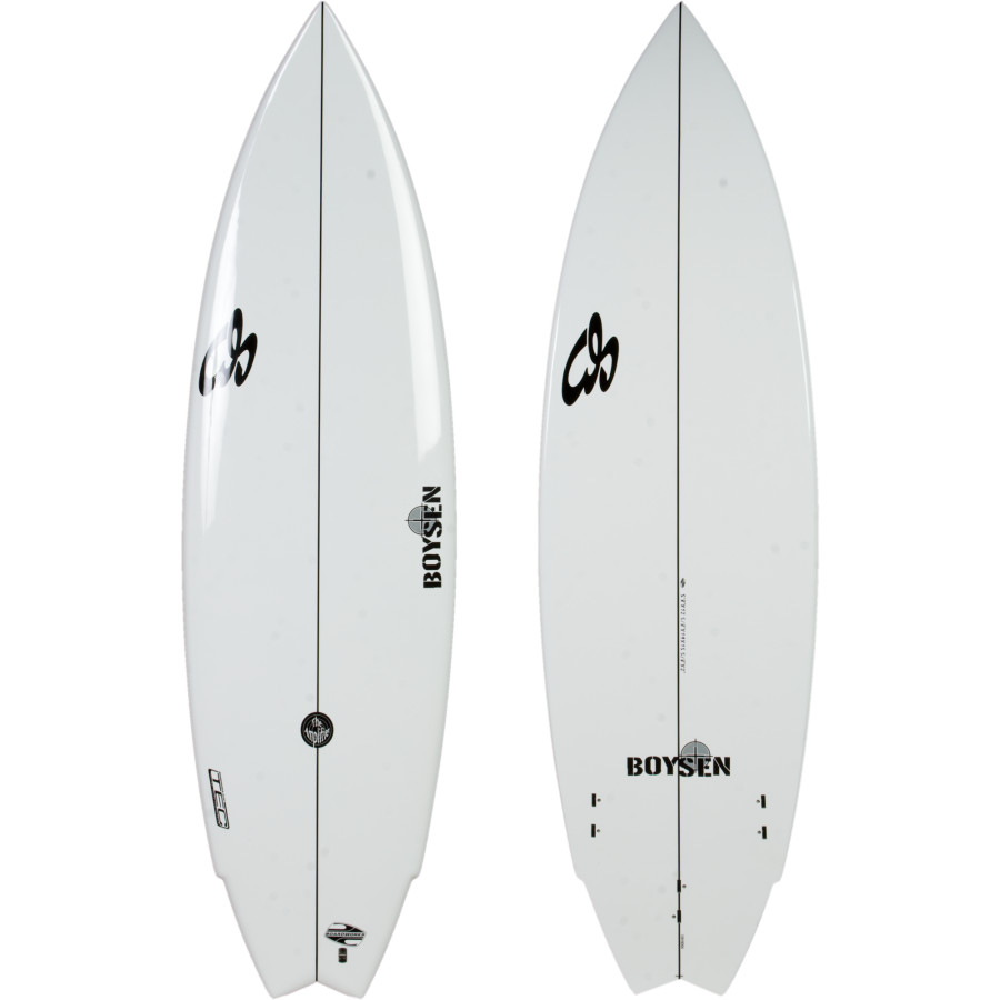
- TEC (Thermal Epoxy Compression) construction technique uses heat and pressure to fuse the epoxy layers to the foam core for added strength and response
- FCS tri-fin boxes set into high density foam that is fused into the core with fiberglass and resin
- Classic fish shape with added nose rocker and modern foil create a more agile yet stable board for aggressive styles
- 5'8" x 19" x 2"
- Price is right at $475
Friday, March 18, 2011
THE Surf Report 3/18/11
Wild Week.
SURF: After the tsunami mess up and down the coast last Friday the ocean dusted itself off and starting churning out real waves again. Tuesday saw some overhead+ waves from the NW with only a slight drop on Wednesday. Thursday the machine cranked back up again with more overhead+ waves. Today we have a slight drop again from the NW with head high sets in north county SD/OC, a foot overhead in south county SD, and about chest high in south OC.
 That won't last for long though as more NW is building on the nor-Cal buoys this morning and by tomorrow afternoon we'll be back into overhead+ waves with slightly smaller surf in south county SD. As usual with these big swells, points are reefs will be your best bet for shape. Sunday drops slightly but there will still be plenty of NW waves but with a little SW wind and rain on it unfortunately (more on that in the weather section below). Tides the next few days are around 3' at sunrise, 6' at 9am, down to -1' at 3pm, and up slightly to 4' at sunset. Water temps are holding at 58- when will summer ever come?! Keep up to date on the waves and weather at
Twitter/North County Surf.
FORECAST:
And the hits keep on coming. After another firing weekend of NW swell, we're due for another solid NW on Monday- similar to the swells we've had all week- look for it to be a few feet overhead in south county SD, overhead in north county SD/OC, and about chest high in south county OC. Unfortunately a cold front will be overhead on Monday so expect junky W winds in the morning followed by strong NW winds in the afternoon. After the wind/weather roll through, we have a drop in size Tuesday afternoon and clearing conditions. Models then show yet another solid NW arriving Wednesday afternoon and peaking Thursday. Spring officially starts on Sunday but by the way the north Pacific has been acting, you'd think it was still winter next week. We also will have some small background SW during the upcoming week but the NW will pretty much be in charge and it won't be noticeable. Maybe southern OC will see a little waist high bump out of it since the NW won't be as pronounced in that region.
WEATHER: Winter doesn't want to end. We're officially at our average rainfall total for the year in SD (slightly more in the OC) so if there was no more rain for the rest of the season (which ends June 30th), we'd be right on track. But we need the rain of course due to years worth of drought, so we'll take a drenching in the springtime. We've got cool low clouds this morning that should break up to hazy sunshine later today. Saturday a weak front moves through for a chance of sprinkles.
 For Sunday though, the clouds increase, the winds also increase from the south, and we're due for rain with the heavier stuff later in the day. We should get around 3/4 of an inch. Showers continue into Monday and we get weak high pressure for Tuesday/Wednesday. Clouds start to increase though Thursday as models show another front on it's way. Too early to predict any rain though...
BEST BET:
Tough one here- today looks fun even though it's smaller- but more beaches can handle the size. Or wait until tomorrow afternoon when that new solid NW arrives and the reefs fire at the low tide. Or sit on your butt, watch March Madness this weekend, and just wait for another good NW next Wednesday with sunny conditions. It's good to have choices.
NEWS OF THE WEEK:
The Vernal Equinox is almost here! Hurray! What the heck is the Vernal Equinox you ask? We'll it's the official start of spring of course, happening this Sunday, March 20th. Our friends at answers.com can shed a little light on the subject: Every year the earth goes once around the Sun; that is, after all, the definition of a year. The earth spins on its axis, and the axis happens to be tilted about 23.5 degrees relative to earth's orbital plane. As a result, sometimes the northern hemisphere is tilted toward the sun and sometimes the southern hemisphere tilts toward the sun. The change isn't severe, but it is enough to cause the seasons. When the north is tilting toward the sun we generally experience warmer weather in the north. When the south is tilted toward the sun then the southern hemisphere generally experiences the warmer weather. (The actual distance from the earth to the sun is not the cause of the seasons. People in the north sometimes find it hard to believe that during the northern winter, the earth is actually a little closer to the sun than it is during the northern summer.) As the earth revolves around the sun there are two moments (not whole days) of the year when the sun is exactly above the equator. At these times neither pole tilts toward the sun. These moments are called "equinoxes". One occurs in March as the northern hemisphere starts to tilt toward the sun. In the north, that equinox is called the "vernal, or spring equinox", the beginning of spring. The other, in September, is the autumnal equinox and is the first day of fall (autumn). In the southern hemisphere, the March equinox is autumnal, and the September equinox is vernal. Around the time of either equinox [equal-night] the daylight period of the day is close to the same length of time as the night time period. The term Vernal Equinox has another meaning in astronomy. It refers to the point in the heavens which is the location of the sun at the moment of the northern vernal equinox. This point is useful as an astronomical marker, but because of something called 'precession' it moves very slowly. At one time this point was called the "First Point of Aries", because it was located just over the boundary of the constellation Aries. So what does spring really mean for us? Well we should see the storm track start to lift with storms producing just showers from fast moving fronts- not steady rain. With the fast moving fronts and lifting storm track, expect less NW groundswells and more WNW windswells. The southern hemi also starts to kick into gear and the best SW of the seasons will occur. Our La Nina is also waning so expect temps to be on the rise in the atmosphere and in our waters. Hopefully less fog than last summer too. So crack a cold one this weekend out of respect for the Vernal Equinox.
BEST OF THE BLOG:
With the recent earthquake in Japan, that makes 3 corners of the Pacific having major quakes in the past year. Guess where the nervous 4th corner is? C'mon, take a guess. Give up? Then you'd better check out the blog below titled 'Earthquakes and Us.' And make sure to click on the earthquake preparedness link...
PIC OF THE WEEK:
 Sion Milosky died unfortunately surfing big Mavericks this past week. He was an underground charger from Hawaii who gained notoriety recently for charging some of the baddest meanest stuff around- paddling no less- as evident by the Pic of the Week (courtesy of Surfer Magazine). You will be missed Sion.
Keep Surfing,
Michael W. Glenn
Handsome Devil
Diagnosed With March Madness
Always Trunking It
SURF: After the tsunami mess up and down the coast last Friday the ocean dusted itself off and starting churning out real waves again. Tuesday saw some overhead+ waves from the NW with only a slight drop on Wednesday. Thursday the machine cranked back up again with more overhead+ waves. Today we have a slight drop again from the NW with head high sets in north county SD/OC, a foot overhead in south county SD, and about chest high in south OC.

Twitter/North County Surf.
FORECAST:
And the hits keep on coming. After another firing weekend of NW swell, we're due for another solid NW on Monday- similar to the swells we've had all week- look for it to be a few feet overhead in south county SD, overhead in north county SD/OC, and about chest high in south county OC. Unfortunately a cold front will be overhead on Monday so expect junky W winds in the morning followed by strong NW winds in the afternoon. After the wind/weather roll through, we have a drop in size Tuesday afternoon and clearing conditions. Models then show yet another solid NW arriving Wednesday afternoon and peaking Thursday. Spring officially starts on Sunday but by the way the north Pacific has been acting, you'd think it was still winter next week. We also will have some small background SW during the upcoming week but the NW will pretty much be in charge and it won't be noticeable. Maybe southern OC will see a little waist high bump out of it since the NW won't be as pronounced in that region.
WEATHER: Winter doesn't want to end. We're officially at our average rainfall total for the year in SD (slightly more in the OC) so if there was no more rain for the rest of the season (which ends June 30th), we'd be right on track. But we need the rain of course due to years worth of drought, so we'll take a drenching in the springtime. We've got cool low clouds this morning that should break up to hazy sunshine later today. Saturday a weak front moves through for a chance of sprinkles.

BEST BET:
Tough one here- today looks fun even though it's smaller- but more beaches can handle the size. Or wait until tomorrow afternoon when that new solid NW arrives and the reefs fire at the low tide. Or sit on your butt, watch March Madness this weekend, and just wait for another good NW next Wednesday with sunny conditions. It's good to have choices.
NEWS OF THE WEEK:
The Vernal Equinox is almost here! Hurray! What the heck is the Vernal Equinox you ask? We'll it's the official start of spring of course, happening this Sunday, March 20th. Our friends at answers.com can shed a little light on the subject: Every year the earth goes once around the Sun; that is, after all, the definition of a year. The earth spins on its axis, and the axis happens to be tilted about 23.5 degrees relative to earth's orbital plane. As a result, sometimes the northern hemisphere is tilted toward the sun and sometimes the southern hemisphere tilts toward the sun. The change isn't severe, but it is enough to cause the seasons. When the north is tilting toward the sun we generally experience warmer weather in the north. When the south is tilted toward the sun then the southern hemisphere generally experiences the warmer weather. (The actual distance from the earth to the sun is not the cause of the seasons. People in the north sometimes find it hard to believe that during the northern winter, the earth is actually a little closer to the sun than it is during the northern summer.) As the earth revolves around the sun there are two moments (not whole days) of the year when the sun is exactly above the equator. At these times neither pole tilts toward the sun. These moments are called "equinoxes". One occurs in March as the northern hemisphere starts to tilt toward the sun. In the north, that equinox is called the "vernal, or spring equinox", the beginning of spring. The other, in September, is the autumnal equinox and is the first day of fall (autumn). In the southern hemisphere, the March equinox is autumnal, and the September equinox is vernal. Around the time of either equinox [equal-night] the daylight period of the day is close to the same length of time as the night time period. The term Vernal Equinox has another meaning in astronomy. It refers to the point in the heavens which is the location of the sun at the moment of the northern vernal equinox. This point is useful as an astronomical marker, but because of something called 'precession' it moves very slowly. At one time this point was called the "First Point of Aries", because it was located just over the boundary of the constellation Aries. So what does spring really mean for us? Well we should see the storm track start to lift with storms producing just showers from fast moving fronts- not steady rain. With the fast moving fronts and lifting storm track, expect less NW groundswells and more WNW windswells. The southern hemi also starts to kick into gear and the best SW of the seasons will occur. Our La Nina is also waning so expect temps to be on the rise in the atmosphere and in our waters. Hopefully less fog than last summer too. So crack a cold one this weekend out of respect for the Vernal Equinox.
BEST OF THE BLOG:
With the recent earthquake in Japan, that makes 3 corners of the Pacific having major quakes in the past year. Guess where the nervous 4th corner is? C'mon, take a guess. Give up? Then you'd better check out the blog below titled 'Earthquakes and Us.' And make sure to click on the earthquake preparedness link...
PIC OF THE WEEK:

Keep Surfing,
Michael W. Glenn
Handsome Devil
Diagnosed With March Madness
Always Trunking It
Tuesday, March 15, 2011
Surf Check 3/15/11
Lots of size today from the NW. The buoys off central CA started filling in nicely yesterday afternoon and the swell hit our beaches this morning. Currently the surf around town is head high with sets a few feet overhead. South county is bigger- best spots are double overhead. Break out the rhino chasers! The wind isn't too bad either- around 7mph from the SW in north SD and OC with slightly stronger 12mph W wind in southern SD.
 The swell has hit it's peak and will be smaller tomorrow but luckily the Pacific has been active and we have another similar sized NW swell on the charts for Thursday.
 The weather unfortunately starts to change by the weekend as a couple of fronts move into the region. Saturday it looks like showers are on tap and Monday some rain.
 That should clear out and yet another NW will arrive around Tuesday- probably head high+ (a little smaller than this week's swells). Looks like winter won't go away quietly.


Monday, March 14, 2011
Friday, March 11, 2011
Deal Alert! Wetsuits for Winter!

Tsunami Warning and THE Surf Report

SPECIAL STATEMENT:
Unfortnately an 8.9' earthquake hit Japan this morning and a subsequent 3'
tsunami surge has hit the Hawaiian Islands. 3' doesn't sound like much but you
have to remember it's not a 3' wave that hits a beach than dissipates but rather
a 3' wall of water that surges up the beach and pushes everything out of it's
way. Luckily the damage so far has been minor in Hawaii as the surge rushed up
the beach and stopped at the beach wall effectively keeping it from the hotels.
What it means for us is that the same surge is going to hit us between the 9 and
10 AM hours this morning, slightly smaller at 2'. STAY OUT OF THE WATER. You
don't want to get sloshed around and pushed up against the rocks or sucked out
to see. With that being said, on to THE Surf Report...
SURF:
After some bumpy windy NW surf early in the week, high pressure set up shop and
Wednesday had some great weather with chest high peaks. Thursday the NW dropped
but a new SW started to show on the buoys. Today we still have small SW with
building NW. Most beaches are waist to chest high this morning with bigger sets
in south county SD.- and a little fog hugging the coast. Look for the NW to fill in even more
tomorrow for head high waves in north county SD/OC, chest high waves in south OC, and
overhead surf in south SD. Sunday drops slightly. Should be a fun weekend of surf overall.
Tides are mellow the next few days; around 1' at sunrise, about 2.5' mid-afternoon and
back down to 2' at sunset. Water temps dropped slightly again due to the
windswell earlier in the week; we're a chilly 57 degrees. Make sure to keep up
to date on the waves and weather with Twitter/North County Surf.
FORECAST:
After a fun weekend of combo surf, the southern hemi stays somewhat quiet with
only background knee to waist high pulses headed our way but the north Pacific
stays active. We get another shot of shoulder high+ NW for north county SD/OC,
overhead in south SD, and waist high for south OC. That drops off mid-week but
models show a promising overhead+ NW towards Thursday. It's still a week out,
but I'm hoping the computers are right and this one has lots of overhead waves
for everyone.
WEATHER:
Our great weather Wednesday/Thursday starts to fade slightly for the upcoming
weekend but it won't be that much of a drastic change. Seems as though we have a
cold front moving by to the north so it will kick up our morning/late night fog
at the coast. Temps should be in the low to mid-60's. Kind of cool but it will
be sunny. It's still winter, right? Can't complain. Early next week we should
have less extensive low clouds/fog at the coast but it really won't get above
the high 60's. Models even hint at showers late in the week but we'll have to
keep an eye on that.
BEST BET:
Tough call here- Do I go with the combo SW/NW on Saturday with spring
conditions? Or the more solid NW next Thursday with a chance of showers maybe on
the edge of our window? I guess the only way to find out is to sample both...
NEWS OF THE WEEK:
It's finally here! Daylight Saving Time! Actually, it didn't seem that long ago
that we set our clocks back one hour on the first Sunday of November. Didn't it
seem like as kids, Daylight Saving Time only lasted a few months- not this crazy
8 month stretch we embrace now? I guess during the 1973 oil embargo (yes, gas
was out of control back then too), the U.S. Congress extended Daylight Saving
Time to 8 months, rather than the normal six months. During that time, the U.S.
Department of Transportation found that observing Daylight Saving Time in March
and April saved the equivalent in energy of 10,000 barrels of oil each day - a
total of 600,000 barrels in each of those two years. Likewise, in 1986, Daylight
Saving Time moved from the last Sunday in April to the first Sunday in April. No
change was made to the ending date of the last Sunday in October. Adding the
entire month of April to Daylight Saving Time is estimated to save the U.S.
about 300,000 barrels of oil each year. And then finally, beginning in 2007,
Daylight Saving Time commenced on the second Sunday in March and ended on the
first Sunday in November, thereby saving even more oil. And what does that mean
for all of us? Higher gas prices! I don't get it. Long story short, remember to
set your clocks forward 1 hour when you go to bed this Saturday. You'll finally
be able to surf after work now. That's all I care about. Screw the whole oil
saving thing. I'm still paying $4 at the pump unfortunately.
BEST OF THE BLOG:
A good one this week if I don't say so myself. Or just bizarre. Your decide.
Surf checks, Wal Mart freaks, and new kicks from DVS. Sounds like a weekend with
Sheen and Lohan. Make sure to view keep viewing the North County Surf Blogspot for
everything that is good in this world!
PIC OF THE WEEK:

I've always been facinated by Nova Scotia. There are endless set ups for perfect
point break surf but the only consistent waves are during the harsh cold winter
months with snow on the beach and air temps sometimes below 0. That leaves
summer time as a better option but you're left waiting for months on end for
hurricanes to aim your way. Kind of reminds me of Santa Barbara- totally useless
in the summer due to the Channel Islands blocking south swells. Oh well, at
Keep Surfing,
Michael W. Glenn
Hustler
Playing 'Jack' In The Jack In The Box Commercials
President Dave Macauley Fan Club
Thursday, March 10, 2011
Deal Alert! Break Out The Spring Break Threads!


Hide the Women and Children!


Subscribe to:
Posts (Atom)