Thursday, August 25, 2016

THE Surf Report- Early Edition


And we're back!

SURF:


Sorry for the lack of THE Surf Report last week. But you already knew there were waves last weekend. And if you didn't, you must have been stuck at a soccer tournament in Mission Viejo. Either way, we have more surf this weekend. Before you get excited, let me just say it's not time to dust off the step up yet, but there will be a couple fun waves from a variety of sources.


First up is a small southern hemi swell that filled in today and brought chest high sets up and down the coast. Along with it was some NW windswell and the beach breaks were peaky. That holds into tomorrow.


We also have Tropical Storm Lester rolling off Baja tonight that should give us some waist high waves Sunday and chest high waves for the OC. Lester could gain minimal hurricane status over the weekend but unfortunately it's moving away from us. All in all a fun weekend with mild weather and contestable surf.


Water temps have rebounded slightly from the low 60's last week to the mid-60's this weekend and tides the next few days are 3' at sunrise, down to 2' at lunch and up to 6' at sunset.

FORECAST:
The surf keeps on rolling Monday with chest high waves and we start to get another increase in SSW swell on Tuesday.

By Wednesday we should have shoulder high sets and more NW windswell in the water.


Surf starts to drop next weekend but charts show a good storm off New Zealand around the 1st of September which should give us head high+ SW around the 9th. Still not time to break out the mini-gun but it's a start. Make sure to keep up to date on any developing storms at Twitter/North County Surf.

WEATHER:


Nothing to really talk about for the next 7 days. Weak low pressure is up north this weekend and that kicks up our clouds down here along with slightly cooler temperatures. No big deal- just not a hot beach weekend. Temps look to be in the low 70's and the clouds will be slow to burn off at the coast. Models show high pressure building early next week and we get a slow warm-up but no real heat wave yet- maybe high 70's at the beaches. Deserts may have a flare up of hit and miss thunderstorms this weekend but that's the only real excitement in southern California for the near future.

BEST BET:
Next Wednesday with peaking shoulder high SSW or daydream and hope for bigger SW on the 9th.

NEWS OF THE WEEK:


The colder than average water temps the past week make it official -- El Niño is dead. But its demise doesn't necessarily mean the earth is in for a breather when it comes to wild weather. Our friends at CNN elaborated for us recently that the evil the twin of El Nino, known as La Nina,  will make a mess of things in it’s own right:

The recent El Nino -- characterized by warming waters in the eastern Pacific Ocean -- has been one of the strongest ever recorded, and its impact has been felt far and wide. Record smashing temperatures hit Thailand, Laos and Cambodia. In Malaysia, lakes dried up and vegetables withered. Weak monsoons and killer heatwaves left India barren and praying for rain. Storms pounded the Northern Californian coast, leaving apartments teetering on cliff edges as backyards dropped into the ocean. The weather system may have even contributed to the spread of Zika by creating conditions that helped mosquito populations thrive.


So now what?

Just as with El Niño, the most consistent and significant impact of La Nina will be noticed in the regions that border the Pacific Ocean, where the winds and ocean temperatures show the greatest variation. Wetter than normal conditions are likely for northern Australia and Indonesia, as well as the Philippines.
This rainfall will be welcome in some areas, as El Niño fueled droughts have plagued much of Southeast Asia for the past several months.

La Niña is also expected to give a boost to the Southwest Monsoon over India, which after two disastrous, drought-inducing monsoon seasons, is expected to be above average this year. La Niña events have previously seen a drop in global average temperatures, which will be welcome news after the recent heatwaves that have struck the region. However, it's not all positive. "La Niña increases the risk of intense storms and tropical cyclones for Australia's east coast," says Dr Agus Santoso, a senior scientist at the University of New South Wales. "While La Nina brings more rain which is good for farming, there are concerns. Flood mitigation measures should be in place."


What about the other side of the Pacific?

Western South America will probably see drier than normal conditions, with the potential for drought in Peru and Chile. In the U.S., La Niña is likely to bring drier than normal conditions in the Southwest, as well as the Rockies and Southern Plains. Enhanced rainfall normally arrives in the Pacific Northwest and to a lesser extent over the Ohio Valley, as well as below normal temperatures.  But perhaps the most impactful characteristic of La Niña in North America is the role it can play in the hurricane seasons. The Atlantic hurricane season generally sees an increase in the number of hurricanes and tropical storms due to weaker wind shear, which can inhibit tropical systems from forming. Over the past decade there have been seven hurricanes or tropical storms that caused at least one billion dollars of damage in the U.S. 5 of the 7 came during the La Nina years of 2008 and 2011 -- including Hurricane Ike in September of 2008, which caused over $30 billion in damage and resulted in 112 deaths.


So what exactly is La Niña?

La Niña is the cool phase of the El Nino-Southern Oscillation (ENSO) climate pattern -- a naturally occurring phenomenon that involves fluctuating ocean temperatures in the Pacific. La Niña is the opposite of El Niño, which is the warm phase of the cycle.  El Niño is characterized by a warming of the waters in the central and eastern Pacific Ocean. La Niña features a cooling of those same Pacific waters.  A La Niña setup begins when strong, easterly winds blow the top-most, warmer layer of water towards Australia and Indonesia, leaving the central-eastern Pacific Ocean as much as four degrees below average. Experts say that sea surface temperatures have dropped and been neutral since mid-May, which has signaled the demise of El Niño. Climate models suggest the Pacific will continue to cool, and according to the U.S. National Oceanic and Atmospheric Administration (NOAA), there is a 75% chance of a La Niña forming by the end of this year.

What happened during the last one?

The most recent La Niña weather pattern began in mid-2010 and continued until 2012. In 2011, Thailand was hammered by three times its average rainfall. More than 75% of the country's provinces saw flooding, which led to more than $40 billion in damage and the deaths of 815 people. In 2010, the system also brought flooding rains to Queensland, Australia, causing 33 deaths and more than $1.7 billion in damages. "The higher sea surface temperature acts like an additional fuel to storms, and the elevated sea level increases the risk of storm surge, coastal erosion and flooding," says Santoso. "These are the kind of catastrophes that exert significant damage to properties and claim lives."

PIC OF THE WEEK:

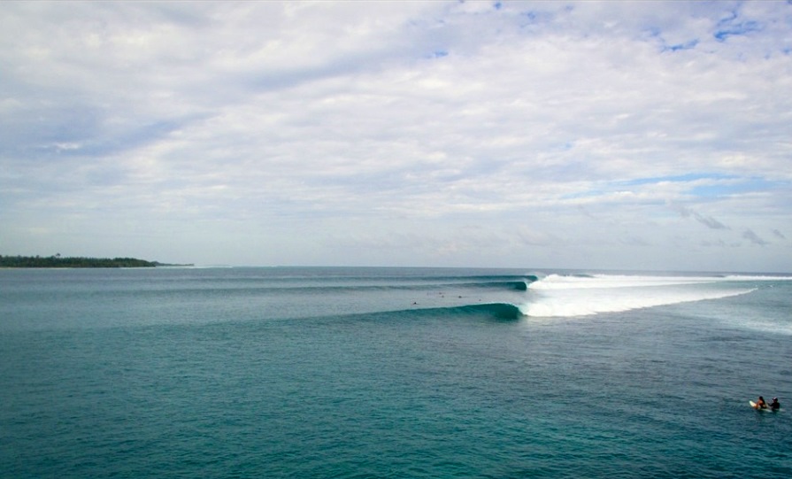
Another right in Indo with some guests of a chartered boat enjoying themselves. It's good to be the king.

Keep Surfing,

Michael W. Glenn
A-OK
Representing Lochte
Discovered 2,871 Surfing Spots and Counting

Thursday, August 11, 2016

THE Surf Report- Early Edition


Patience young grasshopper.

SURF:
In the immortal words of my 10 year old grom: 'Are we there yet'?


Not much to speak of this week. No Chubascos, Monsters from New Zealand, or Aleutian Juice. Just  waist high background SW and maybe a touch of tiny NW windswell. No reason to get excited this weekend either. Models show a little increase in the NW windswell Saturday/Sunday but that may only give us waist high waves again and a tad bigger set in SD.


Water is still nice at 75 degrees and tides this weekend match the surf too: boring. Just 3.5' at sunrise, down to 2.5' at lunch, and up to 5' at sunset. At least we live in a great place so get out there and enjoy the weekend regardless!

FORECAST:
The start to the workweek is looking small, so still no reason to play hooky.

Models today though show a good storm in the southern hemisphere (finally) and we should see a couple chest high sets from the SSW Tuesday afternoon.  Swell peaks Thursday with head high sets and we can all let out a sigh of relief.


Models also show a small NW arriving around the same time so beach breaks could be peaky. After that it goes quiet again. Bummer.


But forecast charts show another storm off New Zealand taking shape around the 18th which may give us shoulder high SW towards the 27th. And in the interim, things could change for the better if the hurricanes decide to play nice. But until then, all quiet off Baja. Make sure to keep up to date on any developing storms at Twitter/North County Surf.

WEATHER:


Nice weekend on tap- at least better than last weekend where the clouds and cool weather decided to hang around as unexpected house guests. High pressure is moving in from the Pacific tomorrow and there will be sun at the beaches by lunch and temps in the high 70's. By the middle of next week we have a chance of monsoon moisture moving in from the deserts but until then, just great summer weather.

BEST BET:
Next Thursday. Unless you have a time machine then anytime you want.

NEWS OF THE WEEK:


If global warming wasn’t a thorn in our side already from rising air temperatures, drought, coral bleaching, stronger hurricanes, blah blah blah, it’s the little things that are just as annoying. Like this report from the New Jersey Institute of Technology:

Batches of sand from a beach on the Delaware Bay are yielding insights into the powerful impact of temperature rise and evaporation along the shore that are giving insight as to what causes beach salinity to fluctuate in coastal zones that support a rich network of sea creatures and plants. The findings have implications for the migration and survival of invertebrates such as mussels and crabs as global warming drives temperatures higher.


A study of the effects of evaporation on water and salinity, or salt content, in the beach intertidal zone was published this week by Scientific Reports. The findings show that sediments from some sections of Slaughter Beach in Delaware have salt concentrations four times as high as the ocean water that washes over them. The finding came as a surprise.

The nearshore seawater the team measured had salt concentrations of 25 grams per liter (g/L), leading the researchers to expect that the subsurface water in areas of the beach it infiltrated would have similar or even lower levels as seawater mixes with inland groundwater in this zone. However, they discovered that the average salinity in the upper intertidal zone -- the high tide line -- was 60 g/L, with some values reaching as high as 100.


"These elevated levels can only be caused by evaporation, as there is no other mechanism for increasing the salt in the water trapped between the grains of sediment," said Xiaolong Geng, a postdoctoral fellow at NJIT and the principal author of the study, noting that the rates of evaporation -- and salinity -- are thus mainly determined by temperature and relative humidity, while tide and wave flows dilute a beach's salt content.

"Previous studies have identified seawater as the primary source of salinity in coastal aquifer systems, thereby concluding that seawater infiltration always increases groundwater mixing dynamics," said Michel Boufadel, director of CNRDP. The team analyzed nearly 400 sediment samples collected during the sequential phases of a complete tidal cycle, from day to night, on seven different days.


What does this have to do with us here in Southern California? Well, we're chock full of intertidal zones here in north county San Diego as well as Bolsa Chica in Orange County. These dynamic habitats, washed by seawater at high tide and uncovered at low tide, are favored by crabs, mussels and sea anemones, the birds and sea mammals that feed on them, and plants such as kelp. Many of these animals burrow in the beach to find food and to seek protection from predators and the action of waves, and are in near constant contact with the salty land. The researchers have developed models that show that increases in temperature associated with global warming will not only make inland locations more salty, but would also create drastically different pattern of salinity that will have implications for animals and plants in the intertidal zone.

"Evaporation is an important driver of underground water flow and salinity gradients, and animals such as mussels and crabs are affected by changes in salinity. If the concentrations are too high or too low, they will move away," noted Geng.

And once they move away, we can finally dredge those lagoons and develop ports for container ships like L.A.!

PIC OF THE WEEK:


Last week's Pic of the Week was a left and this week's Pic of the Week is also a left. What can I say? I'm a goofyfoot!

Keep Surfing,

Michael W. Glenn
Squire
The Coldest Winter I Ever Spent Was A Summer In San Francisco (2nd Time's A Charm)
Starring In the Sequel to Big Wednesday Called Small Thursday

Friday, August 5, 2016

THE Surf Report


Will I ever wear a wetsuit again?

SURF:


Even though the surf hasn't been the biggest (when was the last time you rode your step-up?), the water sure has been warm. A quick snapshot from last week had north county water temps at 78 degrees. For comparison's sake, Maui was 79 (and San Fran was over 20 degrees COLDER at 57. That's awful. Mark Twain said it best: "The coldest winter I ever spent was winter in San Francisco). Regardless, it's almost been unbearable to wear at least a wetsuit jacket. Only trunks will do.


The surf today is some leftover SSW swell that filled in yesterday and a touch more NW windswell. Result is peakier waves than Thursday. Look for chest high waves around town today that back off slightly tomorrow then just waist high surf on Sunday.


Tides the next few days are 0' at sunrise, up to 4.5' at lunch, down to 2' at sunset.


FORECAST:


The southern hemisphere was quiet about a week ago which means quiet for us next week. Look for waist high waves at best from the SW with the OC maybe getting a chest high set if they're lucky at the best spots.


We had a little storm form yesterday off Antarctica which will give us chest high sets towards Thursday.


And then models do though show a big complex storm forming around the 10th of August which would give us head high SSW towards August 17th if everything holds up. Make sure to keep up to date on any developing storms at Twitter/North County Surf.


On a side note, we had a helluva lot of hurricanes last month. After no named storms formed in the eastern North Pacific basin in May or June for the first time since 1969, tropical cyclone activity in July was well above average.  Seven named storms formed in the basin in July, with five of those becoming hurricanes and three becoming major hurricanes. In addition, a tropical depression (now Tropical Storm Howard) formed on 31 July.  The number of hurricanes sets a new record for the most hurricane formations in July, and the numbers of named storms and major hurricanes tie previous records for the month.  It's either feast (July) or famine (May/June) around here. Based on a 30-year (1981-2010) climatology, three to four named storms typically form in the basin in July, with two becoming hurricanes and one of those reaching major hurricane intensity.

In terms of Accumulated Cyclone Energy (ACE), which measures the combined strength and duration of tropical storms and hurricanes, this was the second most active July in eastern North Pacific history, behind July 1992.  The ACE for the season to date is well above normal.

WEATHER:


Not much to talk about. We have a weak low pressure trough hanging over the west coast which will give us night/morning low clouds and hazy afternoon sunshine. Temps at the beaches will be in the mid-70's. That scenario should last most of next week. So that's about it. No tropical clouds, no fog, no heat wave, no rain; just typical San Diego weather.

BEST BET:
Today and then it's kaput until next weekend..

NEWS OF THE WEEK:


You’ve  probably heard the saying ‘More people have been on the surface of the moon than at the deepest part of the ocean” (true- count is 12 to 3 for those of you keeping score). So with the ocean being so massive, it only makes sense that a few undiscovered species pop up from time to time. Like in the case of July 28th of this year, scientists identified a rare new species of whale in the North Pacific Ocean. Which is incredible since whales are one of the most studied animals and it’s kind of hard to not come across something that big.

The whale looks similar to the common Baird's beaked whale, but is slightly smaller and darker. Even Japanese whalers -- who call the species "karasu," Japanese for raven -- rarely see the whale. Scientists from a variety of universities, as well as the NOAA and Scripps Institution of Oceanography, conducted DNA analysis to confirm the species' uniqueness.

The whale's discovery was announced in a new paper, published this week in the journal "Marine Mammal Science. Scientists had to rely exclusively on DNA samples, which were compared to museum gene databases, as intact and well-preserved skeletons have been elusive.


"Every known specimen of this new whale found so far has been dead and, in most cases, decomposing on a remote sub-arctic beach," lead study author Phillip Morin, a molecular biologist at NOAA Fisheries' Southwest Fisheries Science Center, said in a news release. "Without a full skeleton of an adult animal or detailed measurements, we had to use forensic genetics to describe the evolutionary differences of this new species."

Scientists have yet to officially name the whale, but have confirmed the species as a member of the genus Berardiusin. "The challenge in documenting the species was simply locating enough specimens to provide convincing evidence," said Morin. "Clearly this species is very rare, and reminds us how much we have to learn about the ocean and even some of its largest inhabitants."

PIC OF THE WEEK:

With all the talk about Americans moving to Canada if Trump wins the election, I may just move up there regardless of the outcome for waves like this.

Keep Surfing,

Michael W. Glenn
Salt of the Earth
Lighting the Olympic Flame in Rio
Was One of the 'sons' in Maui and Sons