I Can See The Finish Line From Here.
SURF:

Nice to see a storm with only 3/4" of rain instead of 3-4". Are we done with winter yet? If this weekend is any indication, yes we are.

As the storm exits the region tonight, we're left with chest high sets on Friday from dying SW groundswell/NW windswell. For the Saturday/Sunday, the weather will be nice and the swells will be down to the waist high+ range- and slightly bigger towards the OC as the small SW swell will be prevalent. And here are the tides, sunrise/sunset, and water temps for the next few days:
- Sunrise and sunset:
- 6:37 AM sunrise
- 7:09 PM sunset

- Water temps are still 57- hoping to see some trunks by June with the building El Nino
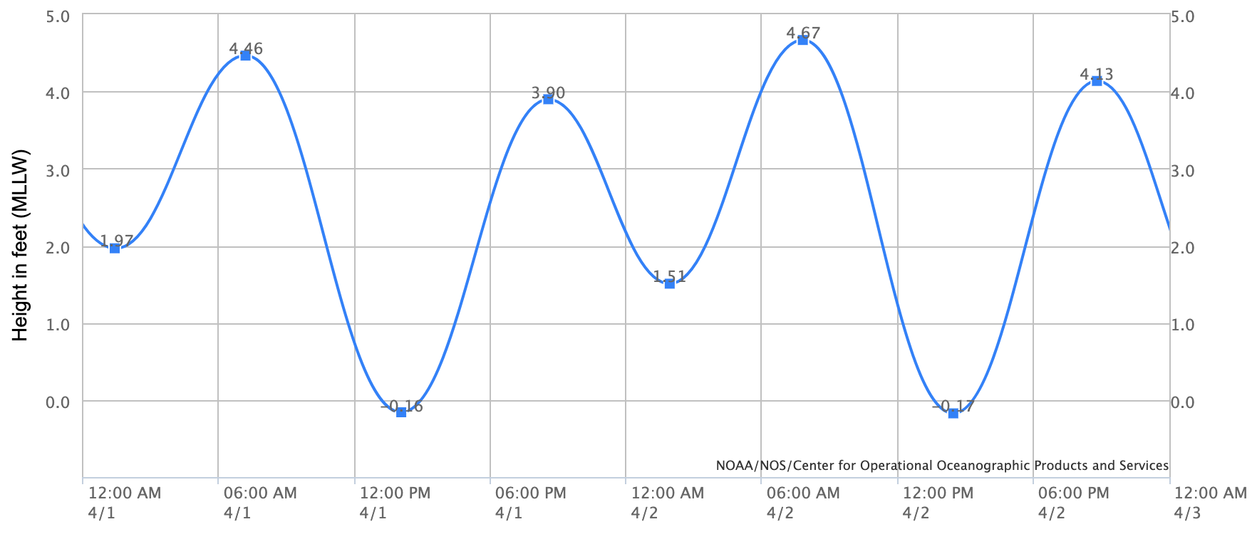
- And nothing too exciting with the tides this weekend:
- about 4.5' at sunrise
- 0' mid-afternoon
- and almost 2.5' at sunset
FORECAST:
Looks like another storm will slide down the coast on Monday but this time... not much in the way of rain for us down here- just wind.

As it moves through, look for overhead NW windswell Monday/Tuesday.

After that, the surf looks small the 2nd half of the week with maybe a shot of more steep waist high+ NW towards Friday.

Then charts show a good SSW swell headed our way for late next weekend. The storm isn't that organized, but it does have a good fetch of wind aimed at us. Look for shoulder high swell towards Sunday. Is winter finally behind us?
WEATHER:

We could be finally done with significant rain here in Southern California- until summer when El Nino kicks in with thunderstorms. In the short term, skies will clear out this weekend and we'll have sunny cool conditions. As mentioned above, a weak front will move through Monday with a chance of light precipitation and a bit of a breeze. Behind it- mainly sunny skies and cool conditions the rest of the week. Here's a quick rundown on the upcoming week:
- Friday to Sunday: Mostly sunny and temps 60/48
- Monday/Tuesday: Cloudy & breezy. Temps 58/45
- Wednesday to next weekend: Sunny and mild. Temps 60/50
If anything changes between now and then, make sure to follow North County Surf on Twitter!
BEST BET:
Tomorrow with small/clean surf or we may have to wait until late next week/weekend until we see any meaningful surf.
NEWS OF THE WEEK:

Early in our winter, we saw a ton of waves, but not a lot of big surf. Then January hit and we got slammed by large out of control surf. And then the past month we saw more rain- but no large surf again. So why the consistent rain this winter but not consistently large waves? Well, let's first look at what makes surf.
There are 4 factors which are important for swell generation:
1. The size of a storm: If a storm is the size of Texas it will make a bigger swell than if a storm is just the size of Delaware.
2. Duration of the wind: If you get a wind gust that lasts a few seconds, you won't see surf from it. But if you get 50 mph winds blowing for 4 days, it will keep building upon the swell it's creating.
3. Strength of wind. 5 mph winds won't give you enough energy to make good surf- but 150 mph winds sure will (here's looking at you Category 5 hurricane).
4. Direction of the swell: If a swell is coming from the NW- and your beach faces S, then the NW has to bend to fit the S facing beach. And as it does, it loses energy.
So how does the wind translate to an actual wave? Waves of course are most commonly caused by wind (or American Waves Machines out of Solana Beach). Wind-driven waves, or surface waves, are created by the friction between wind and surface water. As wind blows across the surface of the ocean or a lake, the constant disturbance creates a wave crest. These types of waves are found globally across the open ocean and along the coast.
Once waves start to form from the wind, this energy passes through water, causing it to move in a circular motion. However, water does not actually travel in waves. Waves transmit energy, not water, across the ocean and if not obstructed by anything, they have the potential to travel across an entire ocean basin.
So back to the storms recently and the lack of large surf here in Southern California. It was all due to high pressure off our coast; storms were getting pushed into British Columbia, then dropping into California. The storm yesterday- and for a lot of them early in the winter- were missing a couple key ingredients from the 4 items mentioned above:
- The size of a storm: The storm yesterday was fairly large, but...
- Duration of the wind: The storm yesterday was short lived which inhibited it's growth...
- Strength of wind. They did have strong winds- but probably the most important missing ingredient...
- Direction of the swell: Unfortunately, it was due N and bypassing us down here.
So even though the storm yesterday was large and had strong winds (as well as dumping rain/snow on California again)- we didn't see large surf from it due to the lack of wind blowing for days on end as well as the steep swell angle.
On the flip side, for the large swells in January, we got 4 out of 4 stars with these:
On the flip side, for the large swells in January, we got 4 out of 4 stars with these:
- The storms were large
- They blew for days on end in the open ocean
- Winds were strong
- And the storms were due W of us (which may be likely with our potential storms during our upcoming El Nino winter)
BEST OF THE BLOG:

Thanks to everyone that has signed up so far for the North County Board Meeting Golf Tournament on Friday, May 12th at Goat Hill Park. Sponsored by our friends at Venture LLP, we're benefiting the Carlsbad Educational Foundation this year. As a reminder, it's first come first serve (and we're filling up fast), so please reach out ASAP to Rich Clark at rich@logicopy.com or Michael Glenn at northcountyboardmeeting@gmail.com to reserve your spot, hole sponsorship, or prize donation. Thank you as always for the support.
PIC OF THE WEEK:

I've got two tickets to paradise. Won't you pack your bags, we'll leave tonight.
Keep Surfing,
Michael W. Glenn
Prevailing
Picking Aztecs Over The Owls
Used 1 of the Tickets to Paradise With Eddie 'Shreddie' Money