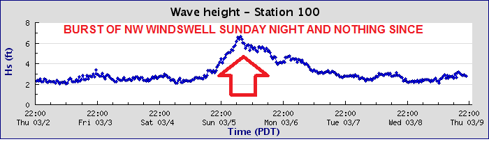
Thursday, March 30, 2017

THE Surf Report- Early Edition


Blow for blow.

SURF:
It's like a title fight out there. A little bit of NW windswell, a little bit of SW groundswell, a little bit of NW groundswell, some sun, some clouds, some early morning offshore winds, some onshore winds- not sure really sure who's in charge here.


We saw a touch of everything this past week. Yesterday we had NW groundswell show up for good shoulder high waves and overhead sets in SD- along with great conditions. Today the NW groundwell backed off while the clouds, windswell, and wind increased due to a cold front moving through the interior western states. For Friday, the NW windswell peaks for overhead sets and that quickly dies on Saturday.

As it does, we have a new fun SW swell for Sunday in the chest high range. Weather will finally be nice too. Fun little waves this weekend with nice conditions is on tap.


Tides the next few days are 0' at sunrise, up to 3' at lunch, and down to 1' at sunset. Water temps are still 60 degrees.

FORECAST:
Busy week coming up with various NW/SW swells on the chart. First up is the leftover SW from Sunday that will continue on to Monday.


We also have new NW arriving but the conditions may be suspect (more on that below). We should see some head high sets.


The SW continues Tuesday and Wednesday has smaller leftovers but will be rideable.


By Thursday we have more NW arriving and the SW starts to pick up again from a storm in the southern hemisphere today. Look for head high sets again. The NW holds into Friday as the SW continues to build for overhead sets. Saturday looks fun as the SW holds and the NW backs off and late next weekend it starts to drop.


The storms in the Aleutians should quiet down by then but Antarctica will stay busy with another head high SW mid-month. Make sure to keep up to date on the changing conditions at Twitter/North County Surf. 

WEATHER:


Spring is acting like, well, spring. Storms are retreating N as we head towards summer so we just get the tail end down here. Another front is moving through northern CA tonight and we're just getting the clouds and breeze down here. Things will clear up this weekend for sunny skies and temps in the low 70's. We get another weak front for Monday/Tuesday and great weather for mid-week. Models then show another front passing by to the N next weekend for more clouds and a breeze down here again. Just like this weekend! Boring.

BEST BET:
Lots of surf next week but conditions may be iffy early in the week. With new good NW/SW on the charts though for Thursday-Saturday late next week, that would be my call. So I'm claiming it.

NEWS OF THE WEEK:


More than half off all beaches in Southern California could disappear by the end of the century due to sea-level rise, according to a study published Monday in the Journal of Geophysical Research.

As a result of sea-level rise, up to 67 percent of beaches from Santa Barbara to San Diego could be completely eroded back to sea cliffs or coastal infrastructure by 2100, according to the report from the U.S. Geological Survey. That's a bummer for Rincon and Malibu but I'm selfish and only concerned with my immediate vicinity. What does that mean for the OC and SD? Obvious trouble spots would be the low lying areas of:


-Seal Beach
-Bolsa Chica wetlands
-All of Huntington Beach
-All of Newport Beach
-Doheny (no loss really)
-All of Trestles
-All of Oceanside
-Ponto and the lagoon at La Costa (the resort will finally be oceanfront)
-Cardiff and the lagoon
-Del Mar and the lagoon/racetrack (where the surf meets the turf- now I get it)
-Torrey Pines, the lagoon, and 5/805 merge (if you think traffic is bad now...)
-La Jolla Shores (no loss really)
-All of PB/MB/OB (no loss really) and Mission Bay
-San Diego Bay and the airport (will make for tricky landings I guess)
-Coronado
-Imperial Beach

“Beaches are perhaps the most iconic feature of California, and the potential for losing this identity is real,” Sean Vitousek, lead author and post-doctoral fellow at the USGS when he conducted the study, said in a press statement.

Replenishment programs that dredge up sand from the ocean and dump it along shorelines have led to a majority of Southern California beaches actually growing in recent years. According to the modeling, those costly efforts, at their current pace, won’t be able to keep up with the rising tides and more powerful weather events of coming decades.

Buffering against these impacts with beach-nourishment programs and sea walls will likely be very expensive, but so would doing little to stop the erosion. The loss of key shorelines could result in billions of dollars lost to local tourism industries, and without the natural buffer of beaches, storms could pummel seaside homes and other structures, as well as threaten lives.

“The effect of California losing its beaches is not just a matter of affecting the tourism economy,” said Vitousek, who is now a professor in the Department of Civil & Materials Engineering at the University of Illinois at Chicago. “Losing the protecting swath of beach sand between us and the pounding surf exposes critical infrastructure, businesses and homes to damage.”

The findings are the result of a new computer modeling program called the Coastal Storm Modeling System. The numerical modeling incorporates predicted sea-level rise as well as anticipated shifts in storm patterns as a result of climate change.

Predicting shorelines conditions decades out is notoriously tricky. However, scientists with USGS have held up this new program because of how accurately it was able to reproduce historical changes between 1995 and 2010.

PIC OF THE WEEK:


Insert your own one word caption for the Pic of the Week. My choice is 'nasty'.

Keep Surfing,

Michael W. Glenn
Unflappable
Brokering The McGregor/Mayweather Deal
Sharks Are Afraid of ME

Thursday, March 23, 2017

THE Surf Report- Early Edition


Stereotypical spring.

SURF:

Spring arrived this week just in time for showers and windy conditions. Any surf we had from the SW/NW was blown to bits unfortunately. This evening the winds started to back off and if you hit it after work, you found a couple fun chest high+ corners. For tomorrow, both swells back off but we'll still have chest high sets from the combo swell and clean conditions. For Saturday, spring rears it's ugly head again and we've got a weak cold front forecasted with showers. Looks feeble like the 'storm' yesterday but it may just be enough for windy conditions.


We also have a small SW showing up and some NW windswell. Sunday looks to be chest high again and breezy from the NW. All in all a little bit of surf this weekend but conditions are suspect.


Water temps are in the low 60's and tides the next few days are 5' at sunrise, down to -1' mid-afternoon and up to 4' at sunset.

FORECAST:
Next week remains murky at best. No real storms to speak of but off and on cold fronts may make the surf a mess. First up, a weak front comes through on Monday afternoon the 27th to give us a slight chance of showers and breezy conditions (just like yesterday).


Surf will be overhead from the NW but bumpy of course. Things should clean up by Tuesday as NW/SW lingers in the background.


Models then show another weak front moving through on Wednesday which will clear out by Thursday for more overhead NW by Friday along with new SW (did you get all that)? The SW will last through the weekend with shoulder high waves.


And further out, models show one more NW in early April and more SW by the end of the first week. All in all a busy end to the month for waves and weather. Make sure to keep up to date on the changing conditions at Twitter/North County Surf.

WEATHER:


Winter won't go away quietly. Even though the powerful storms will stay in the NW, we'll still get the tail end down here for springtime showers and breezy conditions. Look for nice weather tomorrow, then a weak cold front Saturday, then nice Sunday, then another weak front Monday. THEN... nice Tuesday and another weak front Wednesday and hopefully sunny again for the end of the week! In a nutshell- off and on the next 7 days.

BEST BET:
In-between all the weak cold fronts! Keep your fingers crossed for tomorrow, Sunday, Tuesday, and Thursday.

NEWS OF THE WEEK:


Whether you believe in man-made global warming or just the natural cycles of the climatology, fact is we’re warmer than we should be. The National Oceanic and Atmospheric Administration reported this week that Earth had it’s 2nd warmest February, season and year to date, on record. Here's the scoop:

February:
February 2017’s average global temperature was 1.76 degrees F above the 20th-century average of 53.9 degrees, according to scientists from NOAA’s National Centers for Environmental Information. This was the second warmest February in the 1880-2017 record, behind 2016.

Season:
The average temperature from December through February was 1.60 degrees F above the 20th-century average of 53.8 degrees. This was the second warmest for this period, just behind 2015-2016.

Year to date:
The year to date (January through February 2017) average temperature was 1.69 degrees F above the 20th-century average of 53.8 degrees. This was the second-warmest first two months of the year in the record, behind last year.

Other notable climate events and facts around the world last month included:

Continued record-low sea ice extent at the poles: The average Arctic sea ice extent was 7.6 percent below the 1981-2010 average for February, and the average Antarctic sea ice extent was 24.4 percent below average. Both regions logged the smallest February sea ice extent since satellite records began in 1979.

Above-average snow cover in the Northern Hemisphere: The Northern Hemisphere snow cover extent was the 22nd largest in the 51-year record. North America had its 15th smallest, while Eurasia had its 19th largest.

Warmer-than-average lands and oceans: Both the globally averaged sea surface temperature and the land surface temperature ranked as second highest on record for February, the December-to-February season and the year to date.

Continents experienced temperature highs and lows: South America had its third warmest February on record; North America, its fourth; Asia, it’s eighth; Africa, its 10th; Europe, its 17th (tied with 1997); and Oceania, its 25th.

Long story short- if you don’t like the heat- get out of the kitchen! Which I guess means hop on one of those fancy new flights to Mars.

PIC OF THE WEEK:


I know you've probably seen Chris Burkard's work by now, but no matter how many times you've seen it, it's still pretty darn amazing. Yes that's really the Northern Lights. Yes that's a rideable surf spot in the snow. And what I really can't believe- an uncrowded line up in today's world.

Keep Surfing,

Michael W. Glenn
Flawless
Still Have A Perfect Bracket
Designing A Wavepool At Area 51 That Simulates Teahupoo

Friday, March 17, 2017

THE Surf Report


In like a lion, out like a... coyote?

SURF:
JUST when I thought the wet weather was over... we have 2 small storms lined up for next week. But before we get into the details, let's talk about this past week.


Had some on again off again fog/sun while just small SW/NW was on tap. For today, we've got a peaking small NW swell with a touch of SW for waist high waves with inconsistent chest high sets in SD. For the weekend, the NW backs off while the small SW hangs around. Pretty much small waves on tap the next few days with a slight chance of building SW late on Sunday (more on that below).


Tides the next few days are around 1' at sunrise, up to 3' mid-afternoon, and down to 2' at sunset. And water temps are doing their darndest to hold on to the low 60's.

FORECAST:


We've got 1 more day of decent weather which will coincide with a new little SW on Monday for chest high waves. We should also have building NW late in the day Monday that blends in on Tuesday with peaking SW and... a chance of rain/wind- just in time for the 1st day of spring! Wednesday is bumpy as we have head high NW and the cold front exits the region. Thursday at this point looks to be clean with leftover shoulder high NW. Friday is good weather and dying NW in the chest high range.


Then next weekend rolls around and the models show rain again and head high+ NW from the storm. Starting to look a lot like January around here.


Further out, models show a solid NW towards the end of the month and smaller SW. We're still a long ways away, but I'll keep an eye on it for you. Make sure to keep up to date on the waves/weather at Twitter/North County Surf. 

WEATHER:


I think I spilled the beans already- we're due for more rain. First up though is mile weather through Monday with night/morning low clouds/fog. Forecast charts yesterday showed heavy rain/wind for Tuesday/Wednesday but have since backed off slightly. The wild card is if tropical moisture gets pulled into the cold front and increases our rain totals. Regardless, look for wet and breezy conditions Tuesday/Wednesday- just enough to screw up the surf. High pressure builds late in the week for sunny skies and cool weather. Then models show more rain for next weekend. Long story short- next week looks like we're closer to winter than summer.

BEST BET:
Monday with new SW, building NW late in the day, and the last day of clean conditions

NEWS OF THE WEEK:


As a surfer, there’s a few phrases that perk your ears up when mentioned. Like Pineapple Express. Or Aleutian Juice. And the Roaring Forties. Just what exactly are the Roaring Forties though? Back in the day, I knew they were associated with the formation of southern hemisphere swells, but what’s the relationship? Our friends at the National Oceanic and Atmospheric Administration can explain:

Sailors call the latitudes between 40 and 50 degrees south of the equator the Roaring Forties. During the Age of Sail (circa 15th to 19th centuries), these strong prevailing winds propelled ships across the Pacific, often at breakneck speed. Nevertheless, sailing west into heavy seas and strong headwinds could take weeks, especially around Cape Horn at the southern tip of South America, making it one of the most treacherous sailing passages in the world.

The Roaring Forties take shape as warm air near the equator rises and moves toward the poles. Warm air moving poleward (on both sides of the equator) is the result of nature trying to reduce the temperature difference between the equator and at the poles created by uneven heating from the sun.

This process sets up global circulation cells, which are mainly responsible for global-scale wind patterns. The air descends back to Earth’s surface at about 30 degrees’ latitude north and south of the equator. This is known as the high-pressure subtropical ridge, also known as the horse latitudes. Here, as the temperature gradient decreases, air is deflected toward the poles by the Earth’s rotation, causing strong westerly and prevailing winds at approximately 40 degrees. These winds are the Roaring Forties.


The Roaring Forties in the Northern Hemisphere don’t pack the same punch that they do in the Southern Hemisphere. This is because the large land masses of North America, Europe, and Asia obstruct the airstream, whereas, in the southern hemisphere, there is less land to break the wind in South America, Australia, and New Zealand.

While the Roaring Forties may be fierce, 10 degrees south are even stronger gale-force winds called the Furious Fifties. And 10 degrees south of the Furious Fifties lie the Screaming Sixties! We can thank the intrepid sailors of yore for these wildly descriptive terms. And the Roaring Forties for our good SW swells this spring/summer here in California.

PIC OF THE WEEK:


The Pic of the Week comes to you courtesy of Trent Slatter from deepest darkest south Australia. Just when you thought it was safe to go back in the water- with the Gold Coast looking all shiny and pretty for the contest in Oz today- along comes Cyclops. A scary name for a scary wave. Like Jaws. Or Ghost Tree. Or Old Man's (due to the guys over 60 that will run you over in the line-up and parking lot).

Keep Surfing,

Michael W. Glenn
Won A Chicken Dinner
Never Owned Sensible Shoes
Top Pick, Fantasy Surfer

Thursday, March 9, 2017

THE Surf Report- Early Edition


Winter, where art thou?

SURF:
Winter, for the most part, has left the building. No more stormy weather, no more stormy surf. Just sunny skies and small waves. The only leftover from winter is the cold water.


This past week we had some showers Sunday evening and a follow up NW windswell on Monday but that was about it. Tomorrow look for background NW windswell and tiny SW groundswell for waist high+ surf. For Saturday and Sunday- ditto.


Tides the next few days are around 5' at sunrise, down to -1' mid-afternoon, and up to 4' at sunset. Water temps are almost 60! Break out the 3/2!

FORECAST:
The Pacific is starting to heat up. Sort of. Models show little bumps out of the NW and SW but only look for waist high+ surf most of all next week.


If you really want to split hairs, look for a little increase from the SW on Monday,


then a little increase from the NW on Wednesday,


then back to the SW next Sunday the 18th,


and potentially some better NW on the 21st,


and better SW around the 24th. But don't get your hopes up for most any of these swells. Keep the 5'5" fat fish handy.

WEATHER:


Just like the surf, nothing to report. We have sunny skies tomorrow and temps in the mid-70's. Models show some patchy dense fog over the weekend but we'll have sunshine by lunchtime and temps in the low 70's. Monday high pressure sets up shop and temps at the beaches may be towards 80. Tuesday is nice again and by the 2nd half of the week we cool down slightly but still sunny skies and temps in the low 70's. If anything changes, I'll keep you up to date on the waves/weather at Twitter/North County Surf.

BEST BET:
I'm at a loss for words since we're at a loss for surf. From today through next week, all it looks like is waist to maybe chest high NW/SW. Worst case you can sit on the beach with your lady friend.

NEWS OF THE WEEK:


Since Ol' Man Winter has decided to slip out the backdoor, I guess we can start spring a few days early. Might as well turn on Daylight Saving Time this weekend too! It didn't seem that long ago that we set our clocks back one hour on the first Sunday of November. As kids, Daylight Saving Time only lasted a few months- not this crazy 8 month stretch we embrace now. During the 1973 oil embargo (unlike today where oil flows like water- guess we're out of the drought too), the U.S. Congress extended Daylight Saving Time to 8 months, rather than the normal 6 months. During that time, the U.S. Department of Transportation found that observing Daylight Saving Time in March and April saved the equivalent in energy of 10,000 barrels of oil each day - a total of 600,000 barrels in each of those two years. Likewise, in 1986, Daylight Saving Time moved from the last Sunday in April to the first Sunday in April. No change was made to the ending date of the last Sunday in October. Adding the entire month of April to Daylight Saving Time is estimated to save the U.S. about 300,000 barrels of oil each year. And then finally, beginning in 2007, Daylight Saving Time commenced on the second Sunday in March and ended on the first Sunday in November, thereby saving even more oil. And what does that mean for all of us? Not sure- we're all using solar now and oil is like $2 a barrel so we probably don't need Daylight Saving Time anyway. Long story short, remember to set your clocks forward 1 hour when you go to bed this Saturday. You'll finally be able to surf after work now until 7pm. That's all I care about. Screw the whole oil saving thing. Oh- and forget about dawn patrolling it and beating everyone to the surf as the sun will now come up at 7am. Feel free to sleep in.

BEST OF THE BLOG:


Just a reminder- Surf Meeting tomorrow morning at George's sponsored by the North County Board Meeting! Come on down to network, grab some breakfast, a cup of Joe from Ironsmith Coffee Roasters, throw some tail, and learn about our charitable work. Meeting starts at 7, look for the green tent south of the Chart House at George's, and get ready to rip.

And don't forget to save the date: The North County Board Meeting's 3rd annual charity golf tournament on Friday, May 26th. Benefiting Urban Surf 4 Kids, it's a great excuse to blow off a Friday morning. Being held at the world famous Goat Hill, come on down for a great time and a good cause. Details will be posted on our website next week so make sure to check out North County Board Meeting for all the details or email me at northcountysurf@cox.net.

PIC OF THE WEEK:


How FUN does this wedge look?! Just paddle into the 4' side wave and then backdoor the 8' main peak. Easy. For more of life's simple pleasures, check out http://www.owenphoto.com.au.

Keep Surfing,

Michael W. Glenn
Crushing It
Projected #1 Seed, West Region
Counselor, Camp Shred

Friday, March 3, 2017

THE Surf Report


Time to exhale.

SURF:
As our rain and big surf starts to wind down, we finally have time to catch our breath.


Nice weather this week was met with small early season SW swell. Today we have great weather again and small SW/NW for waist high+ surf. Tomorrow doesn't look much different as we have leftover small SW/NW and clean conditions. BUT... low clouds may return on Saturday in advance of a weak cold front.


For Sunday our NW windswell/groundswell starts to pick up but it's because of that weak cold front unfortunately. Look for breezy conditions on Sunday and a chance of showers on Sunday afternoon along with chest high bumpy surf. Nothing major, just enough to mess up any kind of surf we have.


Tides the next few days are about 0' at sunrise, up to 3' after lunch, and down to 1' at sunset. And water temps are holding in the high 50's.

FORECAST:


So the big surf is going to be taking a vacation for awhile. As we're only a couple weeks away from spring, our chances of a big NW grow slimmer. On the flip side, the southern hemisphere is starting to come to life- just not fully awake unfortunately. For Monday we have peaking NW windswell/groundswell from the above mentioned cold front that will give us chest high+ surf. For the rest of the week we have nice conditions and small off and on SW/NW for waist high+ surf.


Best day looks to be MAYBE Wednesday with a small bump of NW for waist high+ surf. I know, nothing to get excited about. After that, the northern hemisphere REALLY shuts down and the southern hemisphere tries to get it's act together.


Models show a small waist high+ SW around the 13th that's short lived. Long story short, time to put away the step-up and break out the groveler.

WEATHER:


Nice weather today gives way to a few low clouds tomorrow. By Sunday a weak cold front comes through the area to kick up our winds and drop 1/3" of showers. After that it's smooth sailing next week with sunny skies and cool conditions. So how did we do for rain this winter? Make sure to check out the 'News of the Week' below and always keep up to date on the waves/weather at Twitter/North County Surf. 

BEST BET:
Hard to say when all of it looks so uninspiring! Today with small leftover SW/NW and nice conditions or next Wednesday with small leftover SW/NW and nice conditions.

NEWS OF THE WEEK:


Darn good winter if you ask me. As we wind down the season and head towards greener pastures, let's take a look back at the 'dry' La Nina we just experienced. As you probably know by now, we got A LOT of rain last Monday when models showed northern Baja was the one that was supposed to get drenched. Well Baja did, but the river of moisture moved ever so slightly N and we got dumped. Models showed Baja getting 3+" of rain and N county SD only getting 1/2". Since that river of clouds moved slightly N, we got 3+" of rain and the OC was the dry one with only 1/2". In total, Palomar Mountain got an unbelievable 9" of rain, our valleys received 4", and the desert incredibly saw 1". So where does that put us for the season? Here's the latest:


As we hit spring here in a few weeks, the big storms should be done and more showery type cold fronts will take their place as the storm track heads N for the summer. All in all maybe another 1" of rain to close out the season?


On the drought front, there's been talk about turning our sprinklers back on, breaking out the Slip 'N Slide again, and finally putting ice in my drink. Well, northern California was fortunate to receive a ton of rain last winter due to El Nino, while down here in southern California, we didn't get much love. This winter of course, the whole state got dumped on. Long story short, up N they're out of the drought, and down here we've got a slight drought still. Luckily for us in so-Cal, the rivers and reservoirs are flowing so we have enough water to meet our household needs. It's our hillsides which are still struggling but they're starting to come back ever so slowly.

BEST OF THE BLOG:


As the heavens finally relent, it's time to get back in the water and give back to your community. Best way to do that? Join the North County Board Meeting. Whether you want to grow your career, give back to the community, support local businesses, or just find an excuse to surf, North County Board Meeting is for you. How can you get involved? First up is our next Surf Meeting on Friday, March 10th. Come on down to network, grab some breakfast, try out the latest SUPERbrand board, and learn about our charitable work. Meeting starts at 7, look for the green tent south of the Chart House at George's, and get ready to rip.


And if you really want to give back to the community, make sure to clear your calendar for Friday, May 26th as it's our 3rd annual golf tournament! Benefiting Urban Surf 4 Kids, it's a great excuse to blow off a Friday morning. Being held at the world famous Goat Hill, come on down for a great time and a good cause. Details will be posted shortly on our website so make sure to check it out next week for all the details.

PIC OF THE WEEK:


So many good photographers coming up right now. Guys like Chris Burkard, Zak Noyle, Alexander Glenn, and today's Pic of the Week from Woody Gooch. Woody hails from Oz but shoots all over the world. And he's not tied down to just surf photos. Woody's clients include Corona (yes please), fashion house DIOR, my kids' favorite- Mountain Dew, and a host of others. Today's pic is in black and white but tells a million stories. Is it Baja? Is it Morocco? How big is it? Where is everyone?! For those answers (maybe) and more, check out Woody's website. 

Keep Surfing,

Michael W. Glenn
Always Right 99% of the Time
Torn Between Siri and Alexa
Complete This Phrase: The Next Phil/MP/Curren/Slater/Dane/JJF______. Correct- It's Glenn