Wednesday, July 25, 2018

THE Surf Report- Early Early Edition


Where do we go from here?
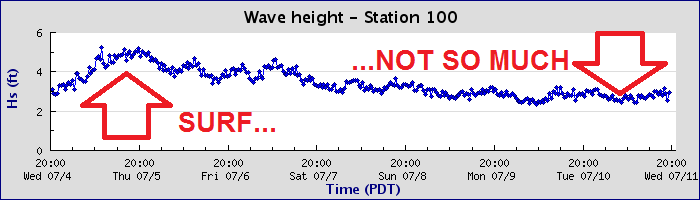
SURF:
Wow. Where do I start? That was a wild few days of surf. 


Saw some fun waves on Sunday afternoon, then really good waves on Monday, and then all heck broke loose on Tuesday. All the while water temps dipped to the high 60's from the NW wind early in the week and rebounded to an amazing 78 degrees in La Jolla yesterday (and for those of you keeping score, that was 1 degree warmer than Waimea Bay and 20 degrees warmer than San Fran). Today the SW swell started to subside but was still plenty fun. For tomorrow and through the weekend unfortunately, the SW swell will continue to drop about a foot each day. Look for shoulder high sets tomorrow morning and down to waist high+ by Sunday. Alas, all good things must come to an end. Did I mention the water was warm? 


As far as the tides go, look for 1' about sunrise, up to 4' mid-morning, down to 2' mid-afternoon, and up to 5' at sunset. 

FORECAST:
If you've read my report over the years, you've heard my theory that as the earth goes through this global warming phase (either man-made or a natural cycle depending on who you voted for), the weather tends to be all or nothing. So in our winters recently, we'll get a big storm- then nothing for a few months. And in the case of this big swell we just had- crickets next week and beyond. 


No storms from the southern hemisphere or off Baja lately means small surf for us for at least a couple weeks. 


We may get a little waist high+ pulse from the SW again on Thursday and MAYBE chest high sets towards next weekend- but that's it. At least the groms can paddle back out now. Hopefully the tropics will kick in between now and then and a hurricane will save us. 

WEATHER:


Before you complain about how hot your house has been at night lately and you can't sleep (for those of us without AC), just know that Death Valley this week has been around 100 degrees. At night. Crikey. So I'll take 70 degrees at the coast at midnight. As you know by now, we've had quite the heat wave the past few days and temps will start to back off slowly through the weekend. Looks for beach weather to be around 80 by Sunday and next week the mid-70's. Patchy fog may stick around the coast each day and thunderstorm activity will increase during the week as high pressure wanes. I guess as the surf drops, so too will the temperatures. Make sure to keep up to date on the latest conditions at Twitter/North County Surf. 

BEST BET:
You're looking at it- get the leftovers today before Mother Nature throws the remnant swell in the trash. 

NEWS OF THE WEEK:


Sharks are all the rage right now. Last week there was a 17’ Great White spotted off San Clemente, the summer blockbuster that started it all, Jaws, was showing at the historic La Paloma this month and if you don’t know by now, we’re in the midst of the Discovery Channel’s 30th anniversary of Shark Week! And if you’ve been at the movies lately, you’ve probably seen the gawd awful trailer for The Meg, Jason Statham’s cash grab this summer in which he's chased around by a 75’ prehistoric shark. So with all of this, I thought it was a perfect time to break out a little trivia about the men in the gray suits… 

1. Sharks do not have bones.
Sharks use their gills to filter oxygen from the water. They are a special type of fish known "elasmobranch", which translates into fish made of catilaginous tissues—the clear gristly stuff that your ears and nose tip are made of. This category also includes rays, sawfish, and skates. Their cartilaginous skeletons are much lighter than true bone and their large livers are full of low-density oils, both helping them to be buoyant.  Even though sharks don't have bones, they still can fossilize. As most sharks age, they deposit calcium salts in their skeletal cartilage to strengthen it. The dried jaws of a shark appear and feel heavy and solid; much like bone. These same minerals allow most shark skeletal systems to fossilize quite nicely. The teeth have enamel so they show up in the fossil record too.

2. Most sharks have good eyesight.
Most sharks can see well in dark lighted areas, have fantastic night vision, and can see colors. The back of sharks’ eyeballs have a reflective layer of tissue called a tapetum. This helps sharks see extremely well with little light.

3. Sharks have special electroreceptor organs.
Sharks have small black spots near the nose, eyes, and mouth. These spots are the ampullae of Lorenzini – special electroreceptor organs that allow the shark to sense electromagnetic fields and temperature shifts in the ocean.

4. Shark skin feels similar to sandpaper.
Shark skin feels exactly like sandpaper because it is made up of tiny teeth-like structures called placoid scales, also known as dermal denticles. These scales point towards the tail and help reduce friction from surrounding water when the shark swims.

5. Sharks can go into a trance. 
When you flip a shark upside down they go into a trance like state called tonic immobility. This is the reason why you often see sawfish flipped over when scientists are working on them in the water.


6. Sharks have been around a very long time.
Based on fossil scales found in Australia and the United States, scientists hypothesize sharks first appeared in the ocean around 455 million years ago.

7. Scientists age sharks by counting the rings on their vertebrae.
Vertebrae contain concentric pairs of opaque and translucent bands. Band pairs are counted like rings on a tree and then scientists assign an age to the shark based on the count. Thus, if the vertebrae has 10 band pairs, it is assumed to be 10 years old. Recent studies, however, have shown that this assumption is not always correct. Researchers must therefore study each species and size class to determine how often the band pairs are deposited because the deposition rate may change over time. Determining the actual rate that the bands are deposited is called "validation".

8. Blue sharks are really blue.
The blue shark displays a brilliant blue color on the upper portion of its body and is normally snowy white beneath. The mako and porbeagle sharks also exhibit a blue coloration, but it is not nearly as brilliant as that of a blue shark. In life, most sharks are brown, olive, or grayish.

9. Each whale shark’s spot pattern is unique as a fingerprint. 
Whale sharks are the biggest fish in the ocean. They can grow to 12.2 meters and weigh as much as 40 tons by some estimates! Basking sharks are the world's second largest fish, growing as long as 32 feet and weighing more than five tons.

10. Some species of sharks have a spiracle that allows them to pull water into their respiratory system while at rest. Most sharks have to keep swimming to pump water over their gills.
A shark's spiracle is located just behind the eyes which supplies oxygen directly to the shark's eyes and brain. Bottom dwelling sharks, like angel sharks and nurse sharks, use this extra respiratory organ to breathe while at rest on the seafloor. It is also used for respiration when the shark's mouth is used for eating.

11. Not all sharks have the same teeth.
Mako sharks have very pointed teeth, while white sharks have triangular, serrated teeth. Each leave a unique, tell-tale mark on their prey. A sandbar shark will have around 35,000 teeth over the course of its lifetime!

12. Different shark species reproduce in different ways. 
Sharks exhibit a great diversity in their reproductive modes. There are oviparous (egg-laying) species and viviparous (live-bearing) species. Oviparous species lay eggs that develop and hatch outside the mother's body with no parental care after the eggs are laid.

So there you have it! Hope you see one at the beach this summer so you can tell all your friends the cool things about sharks.

PIC OF THE WEEK:


I'm out there! Pretty sure the wind will back off soon...

Keep Surfing,

Michael W. Glenn
Can't Stop Looking At Myself In The Mirror
Influencer
Just Went On Ancestry.com and Found Out I'm Related to Kelly Slater! (and Wilbur Kookmeyer Somehow)

Thursday, July 19, 2018

THE Surf Report- Early Edition


All or nuthin'

SURF:


Lackluster week for surf. Partly cloudy, some windy days, and pretty much flat. At least the water was warm. Welcome to the East Coast! 


Fate is on our side though as a solid storm off New Zealand flared up last week and good SW swell is marching towards us as we speak. The buoys should start picking up some 22 second readings tomorrow but we won't see much until Saturday evening- look for some chest high sets by sundown. On Sunday it picks up a notch with sets in the shoulder high range by the afternoon. Basically Saturday is small but fun and Sunday should have waves. 


Water temps are hovering in the low to mid 70's and tides the next few days are 3.5' at sunrise, down slightly to 2.5' before lunch, and up to 5.5' at dinner. 

FORECAST:
Monday the SW continues to build for head high surf and on Tuesday the swell peaks with overhead sets. And as luck would have it, we've got a heat wave building too with temps in the mid-80's. Glad I'm not a lifeguard. Wednesday the swell starts to back off with shoulder high surf and late in the week it's pretty small. 

Further out, the southern hemisphere is taking a nap unfortunately and there's no SW forecasted between the 26th to the 31st. 


Charts though show another storm off Antarctica around the 26th which may give us SSW swell around the 1st of August. 


Models also show a hurricane developing around the 28th with more S swell around the 1st. That's IF the models hold true. So until then, get it while you can. 

WEATHER:


Typical July weather lately. Some low clouds in the AM, tropical clouds mid-day, and a little bit of wind in the afternoons. That will start to change this weekend as we'll be in transition from monsoon moisture and high pressure. By Monday, sunnier skies will start to prevail and the temps will be in the high 70's. The builds all week and models show the heat peaking around Thursday with beach temps in the mid-80's (and the nights 70- wow. Not as bad as Death Valley though with a high of 125 and a low of 95. Wow X 2).  Hopefully things start to cool off by next weekend. Make sure to keep up to date on the latest conditions at Twitter/North County Surf. 

BEST BET:
Tuesday with overhead SW swell, beach temps in the mid-80's, and water temps in the mid-70's. I must have been a good boy lately. 

NEWS OF THE WEEK:


Drones are all the rage. Our military uses them for surveillance, you see them flying over Teahupoo to get footage you never thought possible, heck- even the Olympics used them for some sort of fireworks type synchronized dancing display in the sky. But that's fine and dandy for the sky. What if you need to go under water? And more importantly, go underwater during a hurricane to record and report back data? Well, the National Oceanic and Atmospheric Administration (NOAA) will soon launch a fleet of 15 unmanned drones called 'gliders' in the Caribbean Sea and tropical Atlantic Ocean this hurricane season to collect important oceanic data that could prove useful to forecasters. I'll let NOAA take it from here:

“If you want to improve prediction of how hurricanes gain strength or weaken as they travel over the ocean, it's critical to take the ocean’s temperature and measure how salty it is,” said Gustavo Goni, an oceanographer at NOAA’s Atlantic Oceanographic and Meteorological Laboratory who is helping lead the glider research. “Not just at the surface, which we measure with satellites, but down into deeper layers of ocean waters.” 


NOAA, the U.S. Integrated Ocean Observing System and university partners will begin deploying the torpedo-shaped, remotely-operated, battery-powered gliders from vessels off Puerto Rico and the U.S. Virgin Islands in mid-July. Ten of the gliders will come from the U.S. Navy, and the others from NOAA. 

The gliders will collect the ocean data as they dive down from the surface to a half mile of depth and then regularly resurface several times a day, even during hurricane conditions, to transmit information by satellite to the Global Telecommunications Center used by NOAA’s National Weather Service. 
The data will be available to the public through the U.S. IOOS Glider Data Assembly Centeroffsite link later this summer.

But why does salinity and temperature matter? Glider data, as well as data from other ocean observing systems showing lower concentrations of salt in surface seawater, can be a clue that this lighter water may form a warm cap that prevents cool water from welling up to the surface. This warm cap can then fuel a hurricane’s strength.


Glider data also helps scientists better predict if the cooler water lying just below the warm surface waters is likely to rise and mix with the surface waters and weaken hurricane strength.

An analysis by NOAA and university scientists found gliders provided key ocean information to a NOAA experimental forecast model in 2014 that allowed scientists to significantly improve wind intensity predictions for Category-4 Hurricane Gonzalo.

Since 2014, NOAA has launched two to four gliders each hurricane season in this same region. The Navy collaboration will more than triple the number of gliders, which greatly increases the odds that gliders will be close enough to more tropical storms to provide key data for weather forecasts.

PIC OF THE WEEK:


"In this crowded world, the surfer can still seek and find the perfect day, the perfect wave, and be alone with the surf and his thoughts." -Sebastian Bach. 

My bad, it was Johann Sebastian Bach who said that. Or was it John Stevenson Plumbing? No wait- John Severson! John Severson, Surfer Magazine, 1960. Nailed it! Fore more lonely waves, check out Stu Gibson's work here. 

Keep Surfing,

Michael W. Glenn
Peacemaker
Internet Sensation
The Lesser Known Michael "Jughead" Glenn to Matt "Archy" Archbold

Wednesday, July 11, 2018

THE Surf Report- Early Early Edition


Hit the reset button. 

SURF:


Great surf, weather, and water temps the past few weeks have been replaced by small surf, semi-great weather, and still warm water temps. 


Looks like we're getting a boost from the SSW Thursday afternoon that will last into Sunday morning. Nothing big but we should be back to chest high surf Friday/Saturday and the OC will have shoulder high sets. We also have a little NW windswell for Thursday and Sunday. 


Water temps are a perfect 73-75 degrees and tides the next few days are -1' at sunrise, up to 4.5' before lunch, almost 2' late afternoon, and back up to 4.5' at sunset. 

FORECAST:
Monday is leftover waist high SW and the rest of the week looks small unfortunately. 


There might be a bump from the SW again towards Thursday/Friday but it's only good for waist high+ surf. 


Further out though, models show a solid storm off New Zealand taking shape in a few days which would start to give us head high+ SW surf towards the 22nd/23rd. And the tropics off mainland Mexico have been eerily quiet the past few days, so I'm hoping something flares up and we get a shot of S swell between now and the 22nd. 

WEATHER:


If you like the tropics (but not the expense), then you're going to love the next week here in Southern California! High pressure will continue with just limited night/morning low clouds/fog and temps in the high 70's. Add in some tropical clouds and you've got classic July weather. Along with the warm water temps, you could swear you were in winter time Hawaii- without the rain of course- or the stink eye. Make sure to keep up to date on the latest conditions at Twitter/North County Surf. 

BEST BET:
Friday/Saturday with fun SW swell. 

NEWS OF THE WEEK:


As we wait for the eastern Pacific to kick back into gear and get our hurricanes roaring back to life, the LA Times put out an article this week about the increasing strength of these storms in recent memory. How strong? Well, the Saffir-Simpson hurricane scale is how meteorologists rate the strength of hurricanes. A category 1 is winds of 74-95 mph, all the way to a category 5 with 157 mph winds. But with some storms this century hitting 180-200 mph, maybe it's time to turn the amp up to 11 like Spinal Tap. Or in our case- a category 6. Here's what the LA Times had to say:

As a ferocious hurricane bears down on South Florida, water managers desperately lower canals in anticipation of 4 feet of rain. Everyone east of Dixie Highway is ordered evacuated, for fear of a menacing storm surge. Forecasters debate whether the storm will generate the 200 mph winds to achieve Category 6 status.

This is one scenario for hurricanes in a warmer world, a subject of fiendish complexity and considerable scientific research, as experts try to tease out the effects of climate change from the influences of natural climate cycles. Some changes — such as the slowing of hurricanes’ forward motion and the worsening of storm surges from rising sea levels — are happening now. Other impacts, such as their increase in strength, may have already begun but are difficult to detect, considering all of the other climate forces at work.

But more certainty has developed over the last few years. Among the conclusions: Hurricanes will be wetter. They are likely to move slower, lingering over whatever area they hit. And although there is debate over whether there will be more or fewer of them, most researchers think hurricanes will be stronger. “There’s almost unanimous agreement that hurricanes will produce more rain in a warmer climate,” said Adam Sobel, professor of applied physics at Columbia University and director of its Initiative on Extreme Weather and Climate. “There’s agreement there will be increased coastal flood risk, at a minimum because of sea level rise. Most people believe that hurricanes will get, on average, stronger. There’s more debate about whether we can detect that already.”

No one knows how strong they could get, as they’re fueled by warmer ocean water. Timothy Hall, senior scientist at the NASA Goddard Institute for Space Studies, said top wind speeds of up to 230 mph could occur by the end of the century, if current global warming trends continue. This would be the strength of an F-4 tornado, which can pick up cars and throw them through the air (although tornadoes, because of their rapid changes of wind direction, are considered more destructive). Does that mean the five-category hurricane scale should be expanded to include a Category 6, or even Category 7?

The Saffir–Simpson hurricane wind scale, developed in the early 1970s, ranks hurricanes from Category 1, which means winds of 74-95 mph, to Category 5, which covers winds of 157 mph or more. Since each category covers a range of wind speeds, it would appear that once wind speed reaches 190 or 200 mph, the pattern may call for another category. Last season saw two Category 5 hurricanes, Irma and Maria, with Irma reaching 180 mph. And in 2015, off Mexico’s Pacific coast, Hurricane Patricia achieved a freakish sustained wind speed of 215 mph.

“If we had twice as many Category 5s — at some point, several decades down the line — if that seems to be the new norm, then yes, we’d want to have more partitioning at the upper part of the scale,” Hall said. “At that point, a Category 6 would be a reasonable thing to do.’’ Many scientists and forecasters aren’t particularly interested in categories anyway, since these capture only wind speed and not the other dangers posed by hurricanes. “We've tried to steer the focus toward the individual hazards, which include storm surge, wind, rainfall, tornadoes and rip currents, instead of the particular category of the storm, which only provides information about the hazard from wind,” said Dennis Feltgen, spokesman for the National Hurricane Center. “Category 5 on the Saffir-Simpson scale already captures ‘catastrophic damage’ from wind, so it's not clear that there would be a need for another category even if storms were to get stronger.”


Among the most solid predictions is that storms will move more slowly. In fact, this has already happened. A new study in the journal Nature found that tropical cyclones have decreased their forward speed by 10% since 1949, and many scientists expect this trend to continue. This doesn’t mean a hurricane’s winds would slow down. It means the hurricane would be more likely to linger over an area — like last year’s Hurricane Harvey. It settled over the Houston area and dropped more than 4 feet of rain on some areas, flooding thousands of houses.

In addition to moving slower, future hurricanes are expected to dump a lot more rain. A study by scientists at the National Center for Atmospheric Research this year looked at how 20 Atlantic hurricanes would change if they took place at the end of the century, under the average projection for global warming. Warm air holds more water than cold air — which is why no one complains about the humidity when it’s cold out. The study found hurricanes would generate an average of 24% more rain, an increase that guarantees more storms would produce catastrophic flooding.

The production of horrifying amounts of rain shows another way in which Harvey is a window into the future. One study, which looked at how much rain Harvey would have produced if it had formed in the 1950s, found that global warming had increased its rainfall by up to 38%. Other scientists see Harvey less as a symptom of climate change than an indication of what we can expect in the future. “Whether we’re talking about a change in the number of storms or an increase in the most intense storms, the changes that are likely to come from global warming are not likely to be detectable until 50 years from now,” said Brian Soden, professor of atmospheric sciences at the University of Miami’s Rosenstiel School of Marine and Atmospheric Science.

Warm ocean water provides the fuel for hurricanes, but a hotter world would not necessarily produce more of them. While many scientists for a long time did think an increase in temperatures would produce more storms, they have begun focusing on factors that could suppress the formation of hurricanes. Many models for future climates show an increase in wind shear, the crisscrossing high-altitude winds that tear up incipient tropical cyclones. And they show less of the atmospheric instability necessary for the generation of thunderstorms. But now the thinking is swinging back.

“We used to think 20 years ago that in a warmer climate there would be more hurricanes,” said Sobel, of Columbia. “Then the computer models got better. Most of those started to show fewer hurricanes, not more. No one knew why. Then some of the models started to show increases with warming. So I think we’re back to where we don’t know.”

PIC OF THE WEEK:

These are my least favorite types of pictures- the ones friends send you while scoring on vacation. Thanks bro. 

Keep Surfing,

Michael W. Glenn
Not Short On Confidence
Media Darling
The Surfing Savant

Friday, July 6, 2018

THE Surf Report


Seriously, what are you waiting for?!

SURF:

After a rough start with Fabio yesterday (i.e. building swell, warm water, sunny skies BUT… howling N winds), he’s finally hitting our beaches today with light winds and fun surf. Unfortunately Fabio peaked last night but we still have chest high waves with shoulder high sets in far north county and head high+ in the OC. There’s also a little bit of NW windswell in the water to cross up the Fabio swell, so I guess all that wind yesterday wasn’t for nothing. 


As Fabio backs off today, we have a small southern hemi swell filling in for more chest high surf. Lucky us. That will last into Sunday morning. Along with water temps around 70 and air temps in the mid-80’s, it’s shaping up to be a fun weekend. Get on it! 


Tides the next few days are about 3’ at sunrise, down to 1.5’ mid-morning, and up to 5’ at sunset.

FORECAST:


Monday through Wednesday next week should be on the small side with just background waist high SW well but then it picks up slightly on Thursday with chest high sets from another southern hemisphere swell. That lasts into Saturday. 


Early the week of the 16th looks small again with just (you guessed it) background SW swell then we could get a better SW swell for head high waves the weekend of the 19th if the forecast charts hold true. And in-between all of that- I wouldn’t rule out another hurricane. 

WEATHER:


If the Hurricane Fabio swell and warm water didn’t get your heart racing, then the weather might. As high pressure set up shop yesterday (thanks N winds) our temperatures started to increase too. Today we’ve got lighter winds thankfully and warmer air temps. Look for the beaches today to be in the high 80’s and just a few miles inland, in the mid-90’s. Tomorrow we may have a weak coastal eddy that could spin up some fog early on, but by mid-morning, it’s back to sunny skies and temps in the mid-80’s. Sunday may cool off slightly to the low 80’s/high 70’s but models show increasing tropical moisture from our S so it may feel more humid. That moisture may increase some more on Monday/Tuesday and we have s light chance of thunderstorms along our coast. Coolio. Even if we don’t get a stray shower, we’ll have those awesome tropical clouds overhead. By late next week, we should be back to the low clouds/fog in the nights/mornings and temps in the mid-70’s. Make sure to keep up to date on the latest conditions at Twitter/North County Surf. 

BEST BET:
Today with great weather, warm water, and a visit from Fabio. Or late next week with an increase in SW swell again.

NEWS OF THE WEEK:


This weekend in weather history!
  • ·         2001: Strong monsoon thunderstorms hit our deserts. In Coachella Valley, Highway 86 was washed out and the American Canal overflowed causing $1 million in damage. Borrego Springs reported 3/4” of rain in just 20 minutes and blowing dust with near zero visibility.
  • ·         2011: Monsoonal moisture interacted with an old low pressure system to produce intense thunderstorms. Severe downburst winds of 50-60 mph affected the cities of Perris and Phelan, damaging trees, powerlines, and several homes.
  • ·         2014: A large southerly swell generated by a powerful storm in the southern hemisphere that first arrived at local beaches over the 4th of July weekend peaked on this weekend. Surf heights exceeded 15’ at The Wedge, and reached 10’ at Huntington Beach with widespread 6-8’ sets along other south facing beaches. Two people drowned including a lifeguard during a rescue attempt.
  • ·         1991: Light rain spread over most of the L.A. Basin, a rare event for July. The L.A. Civic Center reported 0.13 inch of rain, a paltry amount for winter, but the third highest single day rainfall in July since records began in 1877
  • ·         1998: Monsoon thunderstorms dropped one-inch hail in Agua Caliente (in the Anza Borrego Desert).
  • ·         1984: Highest minimum temperature records were set each day in San Diego for 15 consecutive days, starting on this day and ending on 7/24.
  • ·         1918: It was 40° in Victorville, the lowest temperature on record for July.


PIC OF THE WEEK:


Not the biggest surf but offshore, long lines, and no one out. Trust me- you’ve surfed worse.

Keep Surfing,

Michael W. Glenn
Titan
Interviewing For The EPA Gig
Just Made A Film About Knee High Blown Out Crowded Surf Called The Endless Bummer