Thursday, July 30, 2015

THE Surf Report- Early Edition


So good so far.

SURF:
What a great week of surf! Until I snapped my board on a floater. Thought I was John John or something. Except John John gets free boards. And free clothes. And a BIG paycheck. And he lives in Hawaii. I'm not bitter. But I'm off track here. That good SW swell (with a touch of NW windswell) the past few days has run it's course and tomorrow we'll still have fun waves but only chest high sets around town and shoulder high towards the OC. Saturday drops further the waist to chest high range.
Sunday morning looks pretty flat but as the tide comes in later in the day, some new SW swell starts to show by sundown. Not big, but we'll be back to chest high sets. At least the water will be warm this weekend- 73 degrees!
Tides the next few days are 0' at sunrise, up to 4.5' mid-morning, down to 1.5' mid afternoon, and up to 5.5' at sunset.

FORECAST:
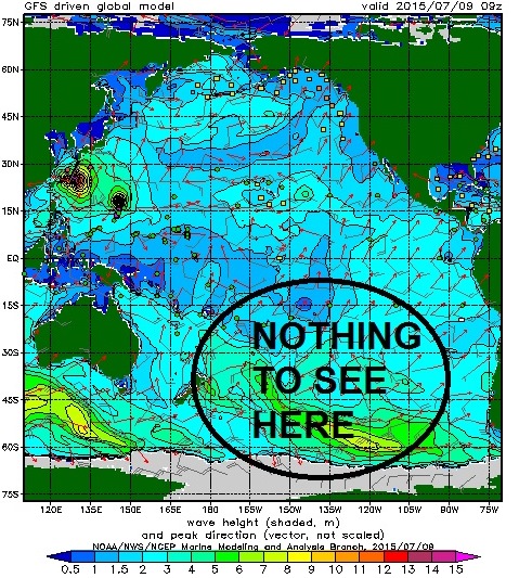
Not much to report- other than Hawaii may get slammed from Guillermo. More on that in a minute.
For us though, the new SW from Sunday peaks on Monday with shoulder high sets in far N county and holds into Tuesday.
Wednesday is small but rideable with chest high sets then forecast models are pretty blah in the southern hemisphere and we'll just get little pulses of waist to chest high SW swell the 2nd half of next week along with a little more NW windswell. At least it won't be flat. Hopefully we'll get another hurricane flare up and send some real waves towards mid-August.
Speaking of hurricanes, Tropical Storm Guillermo is already half-way to Hawaii tonight with 70 mph winds and moving away from us in a westerly direction so don't expect him to be a wave maker in southern California. On the flip side, Guillermo is forecasted to be a category 2 hurricane in a few days with winds approaching 110 mph and headed straight to Hawaii. Bummer on all fronts. Hopefully the islands don't take a direct hit. Make sure to keep up to date on the Guillermo and our surf by visiting North County Surf on Twitter 

WEATHER:

Thunderstorms out in the mountains/deserts, a few big clouds drift towards the coast, temps in the high 70's, and night and morning low clouds. Jeez this weatherman stuff is easy. Pretty much on auto-repeat around here with your typical mid-summer pattern at the beaches. Look for the thunderstorms to back off early next week for more- yawn- low clouds/fog burning off to killer beach days most of next week.

BEST BET:
Monday- new little SW swell, mild weather, and water temps in the low 70's. Is Monday a holiday? Can we move up Labor Day or something?

NEWS OF THE WEEK:

Think we've had wild weather recently? You're right, thanks to El Nino (and it's not even winter time yet- just wait). But this day in history has seen some wild stuff over the years too. Just take a gander:

1991: Thunderstorms brought 0.77 inch of rainfall to La Mesa, 0.58 inch to El Cajon, 0.56 inch to Santee, 0.33 inch to Balboa Park, and 0.23 inch to San Diego Mission Valley and Lindbergh Field (the greatest daily amount on record at the time for Lindbergh Field in July- until Dolores rolled through a couple weeks ago and dumped 1+”). Mobile homes were flooded in La Mesa and homes and streets were flooded in East City Heights and Mission Gorge. Trees were downed and power outages resulted.

1972: During a stretch from 7/28 to this day, the temperature rose each day to 100° in Palomar Mountain. It is the highest temperature on record and has been reached on nine days.

1958: Moisture from a west northwestward moving tropical storm which dissipated west of central Baja California generated up to two inches of rainfall in the deserts and mountains starting on 7/28 and ending on this day. This occurred during the El NiƱo of 1957-58 (sound familiar)? On this day a severe thunderstorm brought heavy rain and hail more than one inch in diameter to Barstow. It was called “the worst storm in 60 years”. A flash flood resulted and actually moved a house off its foundation. Residents had to escape through windows from flooded houses in Lenwood. Tons of mud engulfed highway 66. The hail damaged roofs, cars, and windows. Another thunderstorm struck Twentynine Palms on this day, and floodwaters and mud flowed through the streets and into a few buildings.

1946: A heavy thunderstorm struck Twentynine Palms. Big deal you say? Well, one house was destroyed by a wall of water AND the garage and car in it were carried a half mile away.

1944: It was 30° in Idyllwild, the latest date in the season to record a freezing temperature.

1930: The high temperature was 100° in San Diego, the highest on record for July and the only time it has hit 100° in July.

PIC OF THE WEEK:

If that barrel isn't crazy looking enough, consider the source: SHORE BREAK. Imagine how big this beast was before it got to the inside. Good luck paddling out.

Keep Surfing,

Michael W. Glenn
Last Man Standing
The Sausage King of Chicago
Punched an Orca During the Finals of the '87 Malibu Bud Tour Contest

Thursday, July 16, 2015

THE Surf Report- Early Edition


El Nino + Hurricane = Firing

SURF:

Fun surf last weekend slowly died all week and today we were left with background waist high SW/NW swells. Tomorrow is more of the same with just waist high sets- but at least the water is 72!
Hurricane Dolores has been spinning off Baja the past few days and reached category 4 status with winds around 130mph yesterday. As she moved into our swell window, she started to die, but was still a strong storm. Look for S swell to arrive late Saturday and really show for us on Sunday with shoulder high+ waves and overhead sets in the OC.
Tides the next few days are 0' at sunrise, up to 4' at lunch, down to 2' late afternoon, and up to 4' again at sunset.

FORECAST:
After Dolores has left the building on Monday, we've got small surf on tap next week. There's a big storm forecasted under South America next week but it's pretty far SE of us so we may only get waist high waves from it next weekend. We have a better storm on the charts that should form around the 20th and if so, will give us shoulder high waves around the 28th. And of course there's always the chance of a hurricane popping up in between then. Make sure to keep up to date on the surf by visiting North County Surf on Twitter

WEATHER:

Nice weather has finally graced our shores. Looks like May Gray/June Gloom is in our rearview mirror. Now that doesn't mean we won't get any more clouds this summer- on the contrary- we have clouds coming this weekend thanks to Hurricane Dolores. Dolores of course won't be a hurricane by the time her clouds reach us, but it will be humid and there's a slight chance of showers for us at the coast- but most likely in our deserts/mountains. The clouds will move through Saturday/Sunday then next week should be back to normal with night/morning low clouds/fog and temps in the mid-70's.

BEST BET:
Sunday- tropical weather and hurricane surf. Cabo comes to Cardiff!

NEWS OF THE WEEK:

If you know me by now, I don't sweat the small stuff. Sure we all wish we had more money or we get a ding in our favorite board from time to time or your cell goes blank for no reason- but that stuff we can overcome fairly easily. What I always worry about is big picture. For years I've always thought in the back of my head "What if the sun had a hiccup?" Well, CNN reported this week that scientists have made a discovery about the sun's "heartbeat" that they say indicates that Earth's Northern Hemisphere could experience a deep freeze in 15 years. Awesome. Now before you go acting like Chicken Little this weekend, let's take a deep breath and look at the facts:

The sun has a "solar heartbeat," or cycle of activity, that produces energy that causes sunspots and solar flares. Scientists at Northumbria University in northeast England developed a model that illustrates the history of these heartbeats and that predicts there will be irregularities in them. The model suggests that solar activity will fall by 60% during the 2030s.  According to the Royal Astronomical Society, the researchers studied the sun's magnetic field activity between 1976 and 2008. They compared their predictions with average sunspot numbers, another strong marker of solar activity, the society reported. The researchers' model showed a 97% level of accuracy, said Valentina Zharkova, a Northumbria University mathematics professor. So how cold could it get?  The scientists say their findings could mean a deep freeze like the one Great Britain experienced around 1900, when the Thames River froze over.  CNN meteorologist Brandon Miller says the study looks intriguing, but it has not been peer reviewed, or subjected to the scrutiny of the larger scientific community. "This isn't published research yet," he said. "Our ability to forecast the specifics of a solar cycle is incredibly poor. It's worse than forecasting in a hurricane season." Doug Biesecker, who works at the Space Weather Prediction Center at the National Oceanic and Atmospheric Administration in Boulder, Colorado, agrees with Miller.  He said the research shouldn't give anyone the idea that because the weather may cool, climate change is not something to be worried about. "It's a very complicated issue," Biesecker, an expert in solar physics, told CNN. "Does the sun have a role in our variable climate? Yes. Is the dominant role? No. Even the concept of the sun being responsible for Europe's mini ice age -- it's not hard-and-fast true." Bottom line: The research needs a closer look. So in the meantime, enjoy the tropical weather this weekend because it may be getting cold just over the horizon. Look at the bright side- the cold spell may just offset global warming! (insert nervous laughter here).

PIC OF THE WEEK:

I swear Jimmy Buffet is going to pop out of that boat and start singing. Fine by me- as long as he doesn't paddle out and snake me.

Keep Surfing,

Michael W. Glenn
King Before Lebron, Elvis, and Tut
Still Watch Saturday Morning Cartoons
Only Surfer to go Left at J-Bay. Switchfoot.

Thursday, July 9, 2015

THE Surf Report- Early Edition


Summer is almost here!

SURF:

Pretty fun surf this week- even if the weather didn't cooperate.
That storm off Indo/Oz a couple weeks ago (I'm sure you've seen all the pics on the web of Kandui going Krazy), finally moved past New Zealand last week and into our swell window. It brought us head high surf today with overhead sets most everywhere in north county SD and the OC. That storm held together for a couple days and we'll have more of the same tomorrow. The swell looks to be peaking tonight but we'll still have plenty of shoulder high waves Saturday and Sunday. And if the sun ever comes out, it could be down right awesome around here!
Water temps are hanging on to 70 and tides the next few days are 3' at sunrise, down to 1.5' before lunch, and up to about 5' at sunset.

FORECAST:

The fun SW this weekend starts to wind down the first part of the week then it gets small the 2nd half of next week.
Charts show a couple groups of clouds off Baja tonight and the first one is already on it's way to Hawaii so it's too late to make any surf for us. The second one is closer to mainland Mexico and may build into a hurricane at the end of next week- which may give us surf late next weekend. But that's a long way off. Make sure to keep up to date on the surf by visiting North County Surf on Twitter.

WEATHER:

Still no beach weather yet. For that you have to wait until next week. So until then, enjoy a late season low pressure system (or is it an early El Nino present?) moving through Central CA tonight. We may get drizzle (again) tomorrow morning and a little W wind (again) for the dawn patrol. Once that clears out Friday, we should have sunnier skies on Saturday and MAYBE some nice weather on Sunday. High pressure is forecasted to build early next week for a shallower marine layer, warmer beach weather, and a chance of thunderstorms in the deserts/mountains. Hopefully these clouds are over so we can finally get summer started.

BEST BET:
Get it tomorrow before it's gone next week.

NEWS OF THE WEEK:

What’s the most powerful lobbying group to stop power plants and desalination plants from operating along the coast? Sierra Club? Greenpeace? Surfrider Foundation? Nope. The jellyfish are coming and the plants may be powerless to stop them.

The Washington Post reported recently that blooms of the translucent sea creatures have clogged power plants worldwide, threatening to shutter all operations. Just last week, a coal-fired power plant in Rutenberg, Israel worked hard to unclog its filters from a nearby swarm that could have shut down its cooling system, Haaretz reported.

"Our coal-fired power stations are located by the sea because it takes a lot of water to cool them down," Israel Electric Corp spokeswoman Iris Ben-Shahal told Haaretz. "At that entry point of the water into the cooling systems, we have filters to keep foreign bodies out. The jellyfish, and other things like sea plants, stick to the filters and clog them."

While IEC stayed open despite the swarm -- workers managed to get them unclogged in time -- other power plants haven't been so fortunate. In 2013, a giant swarm of moon jellyfish shuttered the world's largest boiling-water reactor, located in Sweden. The same thing happened at the plant in 2005.

Stuff like this happens more often than you'd think; about two or three times a year, jellyfish blooms cause serious problems for power, desalination and other plants, according to Lucas Brotz of the University of British Columbia's Institute for the Oceans and Fisheries. "In some cases, it's caused nuclear power plants to have near meltdowns," Brotz told The Post.

"I wouldn't say jellyfish are doing this intentionally," Brotz added.


Massive blooms of jellyfish inadvertently get stuck in the plants. They're built on the water's edge and suck in ocean water to cool their systems. Sometimes that water has a bunch of jellyfish in it. Some of the blooms "can almost look like they're more jelly than water," Brotz said.

While having a cooling system shut down can halt operations, a spokesman for the Swedish nuclear power plant that faced swarms in 2013 said at the time that there was no risk of nuclear accident. Representatives with the nuclear power industry contest the notion that jellyfish have caused severe safety problems, such as near meltdowns, and call such characterizations “exaggerated.”

“Given the multiple safety layers that exist at U.S. nuclear energy facilities, periodic complications caused by the presence of jellyfish have not threatened safety, period,” said Steve Kerekes, spokesman with Washington, D.C.-based Nuclear Energy Institute.

The rise in jellyfish has become a problem for industry. Brotz coauthored a 2012 paper published by Hydrobiologia: The International Journal of Aquatic Science that analyzed 45 of the world's large marine ecosystems with an abundances of jellyfish. The researchers estimated that 62 percent of them had increasing trends since the 1950s.

The study authors note there isn't a single cause of such blooms and many populations fluctuate along with the ocean's climate. "Jellyfish have bloomed for hundreds of millions of years and are a natural presence in healthy ecosystem," they write.

But Brotz explained how humans can be exacerbating the rise in blooms, such as with  over-fishing that removes jellyfish competitors and predators.


Jellyfish also survive better than most marine life in dead zones, those oxygen-depleted spots in the ocean that can come about because of pollution. And coastal development gives some jellyfish species more shaded habitat when they're in the polyp stage, which they love.

Brotz said warming ocean waters can cause jellyfish to expand their ranges, have more babies sooner and stick around in certain spots longer.

Jellyfish that get introduced to foreign waters and turn into invasive species can also become massive blooms, Brotz said. This can happen when ships take on ocean water to even out their load or when the polyps, stuck to the sides of boats, get transported elsewhere.

Haaretz reported that the jellyfish that swarmed the plant last week appear to be Rhopilema nomadica, considered invasive in the Mediterranean Sea.

Jellyfish don't just swim aimlessly, but the ocean's currents can push a big blob into unsuspecting territory, Brotz said. So it's become crucial for industry to try to figure out ways to predict jellyfish. Researchers have asked the public to pitch in on the citizen-science research site, Jelly Watch, by reporting jellyfish sightings.

"We're not going to be able to stop jellyfish, but if we can warn a power plant or aquaculture [farm] or even a swimming beach for tourists, 'hey, there's going to be a lot of jellyfish today,' they can prepare for it," Brotz said

PIC OF THE WEEK:

If this wave was shot in better light, it would look more appealing. Scratch that. It's only a face Mother Earth could love.

Keep Surfing,

Michael W. Glenn
Strong. Like Bull.
I Can See Clearly Now, The Rain Is Gone
Just Found Out the Sultan of Speed Wasn't a Real Sultan. Bummer.

Friday, July 3, 2015

THE Surf Report


Getting into the swing of things.

SURF:

Had some fun surf earlier in the week- along with some wild tropical weather. We're back in the swing of things today with normal weather and building SW swell with chest high sets.
For the holiday, look for chest high waves+ with best SW spots hitting shoulder high on the sets. Not the most firing weekend, but just enough to celebrate the 4th in style. And now that June Gloom is gone and the NW wind has turned to SW, water temps have creeped up to the low 70's.
Tides the next few days are -1' at sunrise, up to 4' at noon, down to 2' late afternoon, and up to 5' at sunrise.

FORECAST:

After a fun weekend of surf, we get better surf arriving from that storm off Indo you heard about last week. Look for shoulder high sets on Tuesday evening, building to overhead sets by Wednesday evening. The swell finally peters out by Friday.
After that, it's looking pretty flat with no good storms on the charts. Hopefully the tropics kick into gear with another hurricane- we're due! The last storm we had off Baja was over 2 weeks ago. After a great start, it's looked pretty weak lately.
There's two sets of clouds down there today but they're already 1/2 way to Hawaii so I think it's too late to get any surf from them- if they ever plan to materialize. Make sure to keep up to date on the surf by visiting North County Surf on Twitter at Twitter/North County Surf! 

WEATHER:

The 2 months of May Gray/June Gloom is over and the early summer tropical 'monsoon' weather has come to an end. We're getting into the swing of things again this weekend. Look for low clouds/fog to increase in the night/mornings this weekend into next week and cool sunshine at the coast most of next week. With no high pressure in place though, the clouds may have a hard time completely burning off at the coast. Pretty normal around here.

BEST BET:
Mid-week with a new solid SW swell arriving on our shores.

NEWS OF THE WEEK:

And the rainy season is officially over which ran from July 1st, 2014 to June 30th, 2015. And you already know it was dry. How dry? The L.A. Times reported this week that the last four years have been the driest such period in downtown Los Angeles in almost 138 years, per National Weather Service data. Downtown L.A. received only 8.52 inches of rain this season, or 57% of average. When combined with data from the previous seasons starting in July 2011, they found that downtown L.A. received 29.14 inches of rain, or more than 30 inches short of where it should have been (in comparison- a solid El Nino could bring 20 inches of rain). The previous driest four-year stretch was from 1947 to 1951, when 34.02 inches of rain fell. Downtown’s parched landscape mirrors the broader, historic drought that has wreaked havoc on California this decade. Forests and hillsides across the state are parched and brittle and ready to go up in flames, and farmers in Central California are dealing with water restrictions and suffering crops. Even in some areas in the northern part of the state, where heavy rainfall still occurs, totals are below historic averages, and wildfires can sweep across the landscape and overwhelm firefighters. Many are placing their hopes in a potential El NiƱo this winter, which experts say is strengthening and could put a dent in the state’s drought. It would be a welcome relief. The weather service’s data show that for the first time since record-keeping began in 1877, less than 10 inches of rain fell in downtown Los Angeles for four consecutive rainy seasons. To add fuel to the fire, literally, four of the seven driest seasons in downtown L.A. have come since 2001; this season was also the eighth time since 2001 that downtown saw less than 10 inches of rain, the weather service reported. For the record, the driest single season was from July 1, 2006, to June 30, 2007, when only 3.21 inches of rain fell downtown. And you think the Lakers are in a drought right now. Sheesh!
So what was OC and SD like this past season? Not much better. Newport Beach received 6.85 inches, just 53% of normal, Oceanside received 7.40 inches, just 56% or normal, and downtown San Diego had a couple random downpours this past winter that skewed their numbers to 8.96 inches of rain, 88% of normal. Long story short, we desperately need a good 20 inches of rain this winter from the strengthening El Nino before we can even think about turning on our sprinklers again.

PIC OF THE WEEK:

One of the countless photos coming from that mega swell in Indo last week. I would have been so on it if I hadn't had buckled my Wavestorm recently. Next time.

Keep Surfing,

Michael W. Glenn
Champ
Uncle Sam's Favorite Nephew
Starting the WBL- World Barrel League. Only Curren and Lopez Apply