Thursday, June 29, 2023

THE Surf Report


Sun = Fun

SURF:


Not the biggest surf this week but the water's warming up and we finally have sun! No complaints. For the weekend, surf will drop slightly but the weather will be great. Friday will have leftover waist high+ S/NW and by Sunday we're left with small waist high surf. And here's the sun/tides/water temps for the weekend:
  • Sunrise and sunset this weekend:
    • 5:44 AM sunrise 
    • 8:01 PM sunset 
  • Water temps:
    • Not exactly El Nino-like water temps, and this week was slightly below average still, but we are seeing some 67 degree readings. Maybe if the heat wave materializes this weekend, we'll be back to average and 70 by the 4th?
  • And tides are pretty mellow this weekend:
    • 1' at sunrise
    • 3.5' mid-morning
    • 2.5' around 2 PM
    • and 6.5' at sunset
FORECAST:

After a slow but sunny weekend, we have a few storms on the charts which will give us fun surf next week. 


First up is a new SSW swell arriving late Sunday but will be seen mainly on Monday. Look for chest high sets into Tuesday the 4th. 


After that is a new S swell for waist to chest high surf on Wednesday- and better towards the OC. That should last into Friday. 


In regards to the hurricanes you've probably read about this week- all that NW wind this winter/spring has really made a mess of our water temps- as well as Baja. Temps are cooler than they should be- so the 2 storms on the charts off Mainland Mexico today will meet their demise once they get out from he Baja Peninsula shadow. Don't expect any surf from them- especially with the new SSW swells being dominant. 


After the swells subside late next week, we take a breather for a few days and we may get a real SW swell around here. Why is that important? Because most of the swells this summer have had a steep southerly angle to them which has bypassed most of SD. If we do get that SW, look for shoulder high sets towards July 13th. If anything changes between now and then, make sure to follow North County Surf on Twitter

WEATHER:


Adios winter, Graypril, May Gray, and June Gloom. Time to turn those sprinklers on! High pressure is in control and building into the weekend. Look for mainly sunny skies by mid-morning and temps along the coast in the mid to upper 70's. Weak low pressure returns early next week- but don't worry- clouds should burn off by mid-day and temps for the 4th at the beaches will be in the low 70's. In summary, here’s what we have for the upcoming week:
  • This weekend: Low clouds in the AM, sunny skies by lunch. Temps 75/62
  • Monday through next week: More morning low clouds but sunny afternoons (similar to this past week). Temps 72/60
BEST BET:

4th of July! Fun but small SSW, sunny skies by mid-day, and MAYBE water temps near 70!

NEWS OF THE WEEK:


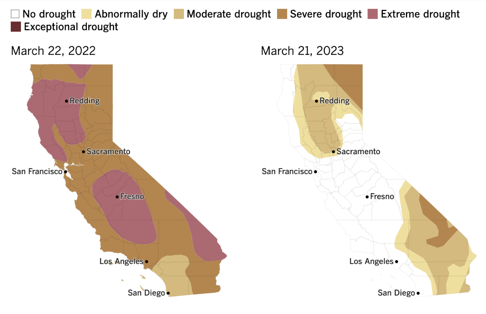
2023 has been a weird year for surf in SD. After a couple BIG winter swells in January, it's been pretty quiet around here. I don't remember the last time I've surfed a head high wave in town. So what gives? And what's in store for later this summer and beyond? Let's have a look:

  • Our winter time weather pattern was dominated by La Nina which basically is high pressure in the Northern Pacific. That SHOULD have resulted in storms from the Aleutians getting pushed into the Pacific NW and leaving us high and dry down here. But the 'La Nina' high pressure this winter was slightly offshore of the West Coast, allowing storms that should have been pushed into Canada, slip down between the high offshore and straight down into California. The result was A LOT of N wind and N windswells. It felt like we were getting East Coast Nor'easters. No big long period groundswells to speak of- just waist to chest high wind bump for months on end. 
  • Unfortunately, that winter pattern has continued to influence our water temps this spring and early summer. All that NW wind for months on end resulted in a lot of cold water upwelling, so we've been below average in our water temps this summer. Not by much- just a few degrees. But surfing in a 3/2 fullsuit vs. boardshorts is a big deal to me. The colder than average water temps have also been felt along the Baja California Peninsula which has kept the hurricanes out of our swell window. Things are finally starting to warm up down there, so hopefully we'll see hurricane surf up here by the end of July. 
  • And the action in the southern hemisphere hasn't been much better. Unrelated to our cold, windy weather up here, our lack of SW swells this summer has been a bummer- especially for the San Diego region. Normally storms in the Southern Hemisphere form off New Zealand and because the swells are generated SW of us in SD (which faces mainly W or NW), we see a bit of that westerly component from the SW. But high pressure has been parked off New Zealand the past few months, so storms are forming more towards South America. The result? More S swells which are better aimed towards the southerly facing beaches of the OC and LA. 
So when are we going to get out of this rut?! Well, it looks like:
  • Our water temps are finally getting a back to normal, so we should see more hurricanes make it to our swell window by the end of July.
  • High pressure may be breaking down off New Zealand we SD could see a good SW swell by mid-July.
  • And if El Nino continues to build this summer, into fall, and hang around this winter- storms won't get pushed into the Pacific NW, but instead take aim due into CA from the due W. 
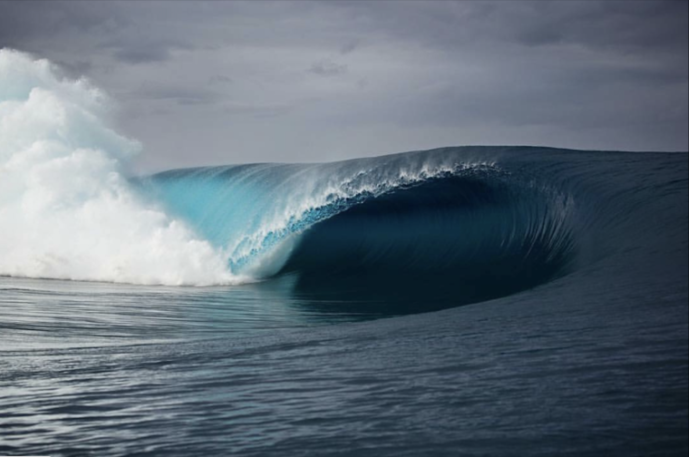
PIC OF THE WEEK:


California from 20,000'. Almost looks affordable from here. 

Keep Surfing, 
Michael W. Glenn
Cosmopolitan
On Track To Becoming The World's 1st Trillionaire
Just Bought A 4'6" Tri Fin With 32L. Seriously. Wish Me Luck This Summer 

Thursday, June 22, 2023

THE Surf Report


2 Steps Up, 1 Step Back

SURF:


What a great week around here. Where do I begin? We had abundant sunshine, the wind stop blowing from the NW, our water temps inched upwards, and we had fun small combo swell. Things are looking up! For the weekend, we have a weak little low pressure system moving by to the N and we'll get a bit more clouds on Friday, but that's about it. The result will be waist high SW/NW combo swell, similar to today. And here's the sun/tides/water temps for the weekend:
  • Sunrise and sunset this weekend:
    • 5:42 AM sunrise 
    • 8:00 PM sunset 
  • Water temps: 
    • We FINALLY have SW winds pooling up our water into the CA bight. Result? Slowly warming water temps. Even though we're still slightly cooler than we should be, most buoys today are 63-65 in So-Cal. 
  • And tides are pretty mellow this weekend:
    • 2' at sunrise
    • 0.5' mid-morning
    • about 4' at 4 PM
    • and 3' at sunset
FORECAST:

Things are looking up around here. After a slow but sunny weekend, we have a few storms on the charts which will give us fun surf next week- and maybe into the 4th of July. 


First up is a medium sized storm off Antarctica a couple days ago which will send chest high sets to S and SW facing beaches on Tuesday. Charts also show another weak cold front moving by to the N on Tuesday also, so we may see a little NW windswell too. 


After that, another good storm is forecasted to spin up this weekend in the southern hemisphere which could give us chest high+ SSW swell at the end of the month. 


And the real eye opener- if the models aren't wack (which they have been recently when it comes to Mainland Mexico) is a hurricane that COULD give us good surf around the 3rd. 


The big if though (and it's a big if) is that the water temps off Mainland Mexico are above average right now (good for storm formation) but as the hurricane moves towards Baja, the waters are colder than average (bad for storm formation). Hopefully the storm is large and it can last as it moves into our storm window. If anything changes between now and then, make sure to follow North County Surf on Twitter.

WEATHER:


When it comes to the sun, better late than never I guess. June Gloom is expected, but not from January to June. As mentioned above, we have a couple weak low pressure systems forecasted to move by to the N on Friday and Tuesday which will make the low clouds a little harder to burn off. But from Saturday to Monday? Sunny skies and temps in the low 70's along the coast. For the 2nd half of next week, that strong high pressure in Texas you've probably read about, that may move ever slow slightly towards the west. If so, we could have a warm up along the coast by next weekend and into the 4th of July. In summary, here’s what we have for the upcoming week:
  • Friday: A little more stubborn low clouds. Temps 65/58
  • Saturday to Monday: Mostly sunny. Temps 70/60
  • Tuesday: More low clouds. Temps 68/60.
  • Wednesday and beyond: Mostly sunny and slightly warmer temps...
BEST BET:

Pretty much Tuesday and beyond. OR... if our 1st hurricane of the season materializes AND stays in our swell window... early July 3rd fireworks?

NEWS OF THE WEEK:


With the potential for Hurricane Adrian to form next week, thought it was time to dive deeper into hurricanes and in particular, how they form. 

Hurricanes are powerhouse weather events that suck heat from tropical waters to fuel their fury. These violent storms form over the ocean, often beginning as a tropical wave—a low pressure area that moves through the moisture-rich tropics, possibly enhancing shower and thunderstorm activity.

As this weather system moves westward across the tropics, warm ocean air rises into the storm, forming an area of low pressure underneath. This causes more air to rush in. The air then rises and cools, forming clouds and thunderstorms. Up in the clouds, water condenses and forms droplets, releasing even more heat to power the storm. As far as water temperatures go, the usual threshold is a storm won't form in sea surface temperatures less than 80 degrees.

When wind speeds within such a storm reach 74 mph, it’s classified as a hurricane. The terms “hurricane” and “tropical cyclone” refer to the same kind of storm: a rotating, organized system of clouds and thunderstorms that originates over tropical or subtropical waters and has closed, low-level circulation.

During just one hurricane, raging winds can churn out about half as much energy as the electrical generating capacity of the entire world, while cloud and rain formation from the same storm might release a staggering 400 times that amount.

Whipping up a hurricane calls for a number of ingredients readily available in tropical areas:
  • A pre-existing weather disturbance: A hurricane often starts out as a tropical wave.
  • Warm water: Water at least 80 degrees over a depth of 50 meters powers the storm.
  • Thunderstorm activity: Thunderstorms turn ocean heat into hurricane fuel.
  • Low wind shear: A large difference in wind speed and direction around or near the storm can weaken it.

Mix it all together, and you’ve got a hurricane—maybe. Even when all these factors come together, a hurricane doesn’t always develop. Same goes for our surf potential here in Southern California:
  • The storm can't be 'hiding' behind Baja California
  • And even if the storm moves into our 'swell window' (i.e. away from the shadow of Baja), best case is to have the storm moves towards us and not aimed at Hawaii
  • The duration of the storm is important- if the winds blow for 6 hours it won't generate much swell. But if a storm blows for 6 DAYS, look out. 
  • Size of the storm is important.
  • And of course wind speed- stronger the better. 
And the moment you've all been waiting for... the Eastern Pacific Hurricane names for 2023!
  1. Adrian
  2. Beatriz
  3. Calvin
  4. Dora
  5. Eugene
  6. Fernanda
  7. Greg
  8. Hilary
  9. Irwin
  10. Jova
  11. Kenneth
  12. Lidia
  13. Max
  14. Norma
  15. Otis
  16. Pilar
  17. Ramon
  18. Selma
  19. Todd
  20. Veronica
  21. Wiley
  22. Xina
  23. York
  24. Zelda
The list of names will re-cycle every six years (the 2023 list will be used again in 2029) UNLESS... a storm is so severe that the World Meteorological Organization's Hurricane Committee votes to retire that name from future lists. And in case you're wondering, as of March 2023, 96 storm names have been retired. 

PIC OF THE WEEK:


Jeffrey's Bay: The right as to which all other rights are measured. 

Keep Surfing, 
Michael W. Glenn
Adored
Collaborating With Pharrell At LV
Shark Whisperer

Thursday, June 15, 2023

THE Surf Report


Summer Is A State Of Mind

SURF:

June Gloom isn't unusual this time of year- but the persistence is. It would be one thing to have at least have some surf in SD with all these clouds lately. 


But no surf, clouds, wind, and cold water? C'mon! 


For the weekend, we had small SSW filling in today for waist high surf in SD and chest high+ in the OC. We also have small background NW. Nothing major- but if the sun comes out- it may look appealing. And here's the sun/tides/water temps for the weekend:
  • Sunrise and sunset on June 21st- the 1st day of summer!:
    • 5:40 AM sunrise 
    • 8:00 PM sunset 
    • And if you happen to be in the surf town of Tofino, British Columbia next week, sunrise and sunset are...
      • 5:18 AM
      • 9:32 PM. Epic!
  • Water temps:
    • May not seem like it, but we're SLOWLY inching towards the mid-60's in some spots along the CA coast today. Maybe one day we can put those 4/3's away and break out the 3/2's.

  • And tides are low/high early/late and medium in the middle:
    • 0' at sunrise
    • 3.5' late morning
    • 2.5' early afternoon
    • and up to 5' at sunset
FORECAST:

Next week changes slightly for the better, I think. 


We've got a new straight S swell again headed our way late Monday (better for Orange County as usual) but we also have some NW wind/groundswell filling in at the same time. Best combo spots could be chest high Tuesday/Wednesday. I'll believe it when I see it. Models though do show yet another low pressure system moving into Southern CA so it could be breezy. Behind that, forecast charts show a storm off Antarctica forming this weekend which could give us chest high+ SW around the 24th-26th timeframe. If anything changes between now and then, make sure to follow North County Surf on Twitter.

WEATHER:


We're still not our of the woods yet with below average air temps and low clouds. We may though see a little more afternoon sunshine though and temps near 70 at the beaches this weekend. That would be a fresh change. As mentioned above, we could have another weak low pressure system moving in early next week for a deeper marine layer and breezy conditions. The 2nd half of next week looks to be cool/cloudy. Here’s what we have for the upcoming week:

•    Friday to Sunday: Maybe some afternoon sun. Temps 70/60
•    Monday to Wednesday: Cloudy/breezy. Temps 65/60.
•    Thursday through next weekend: Mostly cloudy. Temps 68/60.

BEST BET:

If you can handle some bumpy conditions, next Tuesday/Wednesday with NW wind/groundswell and smaller straight S swell. Or just wait until next weekend with better SW.

NEWS OF THE WEEK:


Got a smorgasbord today. Let's start with our weather the past 6 months. We had a La Nina weather pattern in place over most of the Pacific which should have been below average rain and below average air/water temps. The temps part was correct as we've been below average for the past 6 months when it comes to our air temperatures. Low pressure above, an occasional shower, the subsequent WNW wind, and the resulting upwelling has been something to behold for 2023. Stubborn low pressure has given us cloudy skies and upwelling offshore which cools our land temps. Until high pressure builds and we get more SSW winds to pool up the ocean water in Southern CA, we'll look and feel more like April around here than August. On the flip side, the abundance of snow and rain this winter, along the cooler temps this spring, is delaying our wildfire season. 


In regards to our water temps, we should be consistently at 65 degrees by now, but we're sitting at 62-63. Here's just a sampling of water temps around California today: Santa Cruz 61 degrees, Del Mar 61 degrees, and for the heck of it- snow fed Lake Tahoe isn't much better at 58. As mentioned above, the constant W or NW wind off our coast has brought the cold water to the surface and it's keeping us in cloudy skies, colder than average water temps, and cooler than average air temps. What does that mean for hurricanes this summer? Right now, the 'El Nino' region off South American in the Eastern Pacific equator region is on fire (awesome). That warm water though can't migrate towards us due to our WNW winds (bummer). Until those winds back off, we're stuck with a barrier off Baja of water temps cooler than 80 degrees- the threshold for hurricane formation. 


Of course our weather and surf has been extreme the past decade- it's all or nothing. It wouldn't shock me later this summer for our water to be over 80 degrees, hurricanes to move up the coast off Baja, and thunderstorms to be a normal occurrence. 

And as a reminder, it may not seem like summer is just around the corner, but we are hitting the longest day of the year on Wednesday the 21st. The summer solstice occurs at the moment the earth's tilt toward the sun is at a maximum. Therefore, on the day of the summer solstice, the sun appears at its highest elevation with a noontime position that changes very little for several days before and after the summer solstice. In fact, the word solstice comes from Latin solstitium or sol (the sun) + -stit-, -stes (standing). The summer solstice occurs when the sun is directly over the Tropic of Cancer, which is located at 23.5° latitude North, and runs through Mexico, the Bahamas, Egypt, Saudi Arabia, India, and southern China. The sun will be directly over the Tropic of Cancer at 7:47 AM PDT.  For every place north of the Tropic of Cancer, the sun is at its highest point in the sky and this is the longest day of the year. 


You may be wondering why the longest day of the year is not normally the warmest day of the year. There is a lag between the longest day of the year and the warmest average temperatures for most of the mid and high latitude locations. The sun angle is high before and after the summer solstice with a maximum number of daylight minutes.  As the sun begins to move lower in the sky the length of daylight decreases.

This lag in temperature occurs because even though the minutes of daylight are decreasing, the earth's surface and atmosphere continues to receive more energy than just what it receives from the sun.  Average temperatures continue to climb until the sun drops lower in the sky. While the effect is evident in the daily temperature plot, it is more readily apparent by looking at changes in the monthly average temperature. 

So there you have it- cool temps now- warmer temps later this summer! 


BEST OF THE BLOG:


Looking to shake off some rust and get back in the water? Look no further- the North County Board Meeting's got a Surf Meeting TOMORROW- Friday the 16th! And if that's not enough, our friends at Sharp Eye Surfboards will be joining us. Come see the latest and greatest shapes that top pros like Kanoa, Jake, Filipe, Rio, and others are riding to victory. We'll be meeting at George's, just south of the Chart House in Cardiff, at 8 AM. Grab a bite, network, support your local community, catch a couple waves, and start the weekend off right. Look for the tent as always and hit me up at northcountyboardmeeting@gmail.com with any questions. Thanks for the support and we'll see you Friday! 

PIC OF THE WEEK:


The pros are in El Salvador this week. Think I'll turn pro. 

Keep Surfing, 
Michael W. Glenn
Prepared
Replacing Messi at PSG
Surfboard Test Pilot


Thursday, June 8, 2023

THE Surf Report


JUNE ZOOM!

SURF:


I’m trademarking a new slogan. In regards to overcast conditions and non-beach weather, I'm sure you’ve heard of Graypril, May Gray, and June Gloom. Now get ready for… June Zoom! Basically I think we should just bypass June and get to the good stuff- sunny skies, surf, and warm water. I’m writing off June and just want to get to July three weeks early. Who’s on board? In the meantime, we have yet another low pressure system headed towards So-Cal this weekend which will deepen the marine layer, keep the W winds blowin’, and our surf small within arms reach. Look for small SW groundswell and NW windswell for waist high waves this weekend. Water is still in the low 60’s- and no sign of that warmer than usual El Nino blob off Central America headed our way. And here's the sun/tides/water temps for the weekend:
  • Sunrise and Sunset:
    • 5:40 AM
    • 7:56 PM
  • Water temps
    • Still slightly below normal at 63 here in SD/OC
    • And the colder than normal water temps are still extending below Cabo San Lucas- so no go for El Nino fueled hurricanes
  • And tides for the weekend are:
    • 2' at sunrise
    • 0' late morning
    • 4.5' late afternoon
    • and down to 3.5' at sunset
FORECAST:

The OC was the recipient of fun surf this past week (again) while the SSW swells bypassed SD (again). For next week, the OC will join the ranks of SD and be on the small side as we don’t have any swells of interest from Antarctica, Mainland Mexico, or the Aleutians. Look for most spots to be waist high at best.


Our next shot of swell may be around the 18th from the SSW. So until then, pray for sun. If anything changes between now and then, make sure to follow North County Surf on Twitter!

BEST BET:

Friday towards the OC with leftover small SSW or this weekend in SD with small NW windswell. Exciting! 

WEATHER:


Our low pressure woes continue here in California as another weak low pressure system sets up shop above the southern end of the state. The silver lining in all this? The record snow pack in the central Sierras is hanging in there as temps at night are in the high 30’s, only mid-50’s during the day, and a light dusting of snow above 10,000’. Seriously. If you’re a snowsurfer, head to Mammoth in the coming weeks as they’ll be open until the end of July. As far as So-Ca goes, temps SHOULD warm up a couple degrees each day next week with MAYBE less low clouds for pleasant afternoon beach weather. Here’s what we have for the upcoming week:

Friday to Monday: Mostly cloudy. Temps 63/60
Tuesday to Thursday: Slight chance of afternoon sun. Temps 65/60
And a little more sun next weekend? Is that asking too much?

NEWS OF THE WEEK:


As you’ve probably heard the past decade, we’ve seen a lot more juvenile sharks off our waters of Southern California. A recent report sheds light on what the term ‘off our waters’ means (think nearshore), how often they’re underfoot (think too close for comfort), and where they tend to congregate (think Encinitas- north and south). But before you change your summer plans, here’s Smithsonian Magazine to educate us:

Surfers, swimmers and waders in Southern California have been unwittingly sharing the water with great white sharks more often than they likely realize, according to a new study published last week in the journal Plos One.

At two popular beaches, sharks and people swam together 97 percent of the time, the researchers found.

Though that statistic might make some swimmers want to stick to the beach, the study’s authors say the findings should actually reassure outdoor adventurers that sharks pose a low risk to humans, per the Los Angeles Times’ Christian Martinez. Despite what movies like Jaws have led beach-goers to believe, sharks tend to “mind their own business,” as study co-author Patrick Rex, a marine biologist in the “Shark Lab” at California State University, Long Beach (CSULB), tells the publication.

“People think, ‘If I see a shark … I’m going to get bitten, or I’m in danger,’” he says to the L.A. Times. “And what we’ve seen is that that’s not necessarily the case.”The findings also revealed that sharks are swimming a lot closer to the beach than previously thought—instead of miles out, they may be within 50 to 100 yards of where the waves break, or even closer.

To understand great white shark behavior along the coast, researchers flew drones over 26 beaches in Southern California from January 2019 to March 2021. They analyzed more than 700 hours of video footage, making note of where and when waders, surfers, swimmers and stand-up paddle boarders were recreating. They also recorded observations of individual sharks, then compared the sightings to get a sense of the human-shark distribution.


Two areas stood out: one in southern Santa Barbara County, and another in central San Diego County. In these so-called “aggregation sites,” or nursery habitats, the researchers noted a big overlap between water users and sharks—and in particular, juvenile white sharks. Those young creatures like to hang out near the beach to feed on fish, squid and stingrays, as well as bask in the warmer water temperatures and enjoy some protection from predators like orcas, adult white sharks and large mako sharks.

Though the researchers could clearly see sharks and humans in close proximity to one another in the footage, the humans likely had no idea the fish were nearby, per the Sacramento Bee’s David Caraccio. To understand the full implications of this overlap, researchers also dug into shark bite data. They found just one reported incident during the two-year survey period in Southern California, and in that case, the swimmer could not identify the marine animal that bit her. More broadly, they found evidence of just 20 unprovoked white shark bites in the region since 2000.

Conservation efforts have allowed white sharks to flourish along California’s coast. And because of rising temperatures from human-caused climate change, more humans are likely heading to the beach to cool off. Despite these converging trends, the researchers found “little evidence of increased frequency shark bites on humans in southern California,” they write in the paper.

Even so, lifeguards up and down Southern California’s coast may want to use the study’s findings to help inform their approach, per the paper—the researchers expect the shark aggregation sites to change in the future.

“These sharks are highly mobile—they can always be at your beach—but rest assured, the data that we’re getting now indicates that as long as you’re not bothering them, they won’t bother you,” says study co-author Chris Lowe, a marine biologist and the director of CSULB’s Shark Lab, to KTLA’s Cindy Von Quednow.

PIC OF THE WEEK:


I’m so desperate for surf right now, I’d surf this 15’ Teahupoo bomb. Finless. And blindfolded. 

Keep Surfing, 
Michael W. Glenn
Slick
Financial Advisor To Financial Advisors
Widely Regarded As The Foremost Expert On Surfing


Thursday, June 1, 2023

THE Surf Report


Sun's Out! (Kind Of). Fun's Out! (Sort Of).

SURF:

Actually saw the sun for a couple hours this week. So that was exciting. Also saw some light showers around Southern CA too, so that was... exciting? 


The OC was the real winner though this week with fun S swell that basically bypassed SD. 


For today, we have new SSW swell filling in which is better for SD's chances but still not much size. On Friday, look for waist high surf with chest high sets at the best spots. We also have small NW windswell which will bump up the surf. Saturday and Sunday look to be the same. There could be a CHANCE of short lived sun on Saturday afternoon, but don't count on it. And here's the sun/tides/water for the weekend:
  • Sunrise and sunset:
    • 5:41 AM sunrise 
    • 7:53 PM sunset 
  • Water temps are ALMOST 65. Which is average for this time of year- but not exactly El Nino unfortunately.
  • And tides aren't doing much this weekend:
    • 0' at sunrise
    • 3.5' late morning
    • 2.5' mid-afternoon
    • and up to 5' at sunset
FORECAST:

The key phrase for the upcoming week: Get it while you can. 


We had a small storm form a couple days ago off Antarctica which will bring more waist to chest high SSW Late Monday into Tuesday. And just like this weekend, we have NW windswell building too. Those swells will last into Wednesday. After that, it's looking quiet around here. Next SW storm on the maps may form around the 7th which would give us surf mid-month. This could be slightly bigger than this week's surf- I'm hoping at least shoulder high. And maybe we'll see sun by then!

WEATHER:


If you like low clouds, have I got the weather forecast for you! As mentioned above, there MIGHT be a sneak peak of sun Saturday afternoon, but surrounding that? June Gloom. Low pressure today strengthens again earlier in the week with more thunderstorms in the mountains/deserts- and thicker low clouds for us. Here's a quick rundown on the next 7 days:
  • Friday: Mostly cloudy. Temps 65/55
  • Saturday: Cloudy and a touch of sun late afternoon if we're lucky. Temps 65/55.
  • Monday through next week: Overcast (but you already knew that). Temps 65/55.
Until low pressure leaves the area and our water temps warm up. we're stuck with this weather pattern. If anything changes between now and then, make sure to follow North County Surf on Twitter!

BEST BET:

Tomorrow with small but fun combo swell or Tuesday with small but fun combo swell. 

NEWS OF THE WEEK:


As mentioned last week, El Nino conditions are building in the Pacific and it's looking to be a doozy (eventually- more on that below). Regardless of what our cooler than average water temps feel like along the CA coast, the National Atmospheric and Atmospheric Administration this week released their summer hurricane forecast for the Eastern Pacific and it's impressive. Here's what they had to say (and I apologize- it's a long one- so scroll to the bottom and just read the summary if you're prone to boredom):

NOAA's 2023 eastern Pacific Hurricane Season outlook indicates an above-normal season (55% chance). There is a 35% chance of a near-normal season and only a 10% chance of a below-normal season. The eastern Pacific hurricane region covers the eastern North Pacific Ocean east of 140°W and north of the equator.

The 2023 outlook calls for a 70% probability for each of the following ranges of activity:

•    14-20 Named Storms (15 is average)
•    7-11 Hurricanes (8 is average)
•    4-8 Major Hurricanes (4 is average)

Accumulated Cyclone Energy (ACE) range of 90%-155% of the median. ACE is a metric used to express the energy released by a tropical cyclone during its lifetime. These predicted ranges are centered on the 1991-2020 averages of 15 named storms, 8 hurricanes, and 4 major hurricanes.

The eastern Pacific hurricane season officially runs from May 15th through November 30th. The peak months of the season are July-September (JAS).


Reasoning Behind The Outlook:

Two main climate factors are expected to contribute to an above-normal 2023 hurricane season across the eastern (and central) Pacific hurricane basins, as follows:

The latest monthly sea-surface temperature (SST) anomalies reflect ENSO-neutral conditions, on the path to the predicted El Niño, and a negative PDO structure, while also showing the North Atlantic SSTs as above-normal for much of the basin. Dissimilar from the past 2 years, positive SST anomalies are measured in the far tropical eastern Pacific near Peru. However, SST anomalies in the regions where many of the tropical storms and hurricanes form (110°W-140°W) are still below normal. The predicted SST anomaly patterns indicate above-average SSTs across the eastern Pacific hurricane region, though there is some evidence of influence from the negative PDO related circulation pushing cooler waters southward. The cooler waters are expected to occur mainly west of 110°W. SSTs across the Atlantic Main Development Region (MDR) are above normal, and warmer than last year at this time. Historically, this combination tends to be associated with near- or above-normal hurricane activity in the eastern Pacific, as El Niño does tend to have a larger influence, though El Niño concurrent with a negative PDO is not that common (39 of 880 months since Jan 1950).

The most recent forecast from the NOAA Climate Prediction Center indicates El Niño conditions are likely through the hurricane season. The ENSO influence on eastern Pacific hurricane activity is highly dependent upon the background SST patterns across the eastern Pacific hurricane region and the Atlantic MDR. The combination of El Niño and above-normal temperatures in the Atlantic MDR tends to favor increased eastern Pacific hurricane activity, often resulting in a near- or above-normal hurricane season. El Niño combined with a warm Atlantic MDR and negative PDO, can result in a wide range of outcomes, centered just slightly above the 1991-2020 averages. El Niño and a high activity era in the East Pacific, which we may be entering, results in even high named storm, hurricane, major hurricane, and ACE totals.

Expected 2023 Activity:

NOAA's 2022 eastern Pacific Hurricane Season outlook indicates an above-normal season is most likely (55% chance). There is a 35% chance of a near-normal season and a 10% chance of a below-normal season. The 2023 eastern Pacific hurricane season is predicted to produce (with 70% probability for each range) 14-20 named storms, of which 7-11 are expected to become hurricanes, and 4-8 of those hurricanes are expected to become major hurricanes. These ranges are centered above the official NHC 1991-2020 seasonal averages of 15 named storms, 8 hurricanes, and 4 major hurricanes.

An important measure of the total seasonal activity is NOAA’s Accumulated Cyclone Energy (ACE) index, which accounts for the combined intensity and duration of named storms and hurricanes during the season. This 2023 outlook indicates a 70% chance that the ACE range will be 90%-155% of the median. An ACE value of 80%-120% of the median indicates a near-normal season. Values above this range reflect an above-normal season, and values below this range reflect a below-normal season.


The Outlook Reflects 2 Main Factors:

The predicted SST anomaly patterns indicate near to above-average SSTs across the eastern Pacific hurricane region, and above-average SSTs across the Atlantic MDR. In the region where most tropical cyclones form in the eastern Pacific, SSTs are currently below normal. The uncertainty in the outlooks for the SSTs to reverse sign is reflected in the relatively moderate probabilities in this outlook. For the Pacific, these conditions also project onto the negative phase of the Pacific Decadal Oscillation (PDO). In the Atlantic, SSTs project onto the warm (positive) phase of the Atlantic Multidecadal Oscillation (AMO) and the Atlantic Meridional Mode (AMM). Historically, this combination of climate patterns tends to be associated with near-normal or above-normal activity in the eastern Pacific hurricane region. The exact interplay and net result of the interbasin relationships is uncertain and still a focus of ongoing research, and that uncertainty is reflected in the relatively moderate probabilities in this outlook. These conditions do not come about often, with only 39 of 880 months since Jan 1950 having an El Niño during July/August/September aka ‘JAS’ (JAS Niño 3.4 < -0.5°C) combined with a PDO < -0.1 during JAS. The exact interplay and net result of the interbasin relationships is uncertain and still a focus of ongoing research.

The most recent forecast from the CPC favors El Niño (91% chance) conditions during JAS with negligible odds for the development of La Nina (~0%). Historically, El Niño events usually mean more activity for the East Pacific, and often for the Central Pacific. During high activity eras in the East Pacific, typically associated with low activity eras in the Atlantic - which we are not in now, ENSO-neutral can produce about as many storms as El Niño. The conclusion the team drew from that is that during uncertain eras, ENSO can have an outsized impact, but that other factors can increase the uncertainty.

El Niño Favored

ENSO-neutral conditions are present at this time. As of May 22, 2023, the weekly SSTs are currently near average across the central and eastern equatorial Pacific and the SST index for the Niño 3.4 region is +0.5°C. The weekly Niño 3.4 index had been between -0.5°C and +0.5°C since February of 2023. The Niño 3.4 index has shown a significant warming trend since December 2022. The wind and outgoing longwave radiation patterns over the central Pacific are also reflecting a breakdown of the atmospheric response to La Niña forcings, and more influence from intraseasonal modes. Looking forward, the official CPC ENSO outlook indicates a very high confidence in the development of El Niño conditions during JAS 2023. The model-predicted SST anomalies in the Niño 3.4 region generally indicate El Niño (Niño 3.4 index greater than +0.5°C) conditions throughout the hurricane season. The dynamical model average (dashed black line) indicates El Niño through the summer and autumn of 2023, with only one modeling system indicating ENSO-neutral. When using a larger pool of models, that includes multiple dynamical models, multiple statistical models, and unique combinations 21 of 24 models indicate El Niño, with 3 indicating warm but neutral conditions. NOAA’s Climate Forecast System (CFS) and the North American Multi-Model Ensemble (NMME) are predicting El Niño. The CFS predicts below-normal shear over the East Pacific while the NMME predicts well above-normal shear for the same region. The shear predicted by the NMME this year is stronger than what was predicted last year (further from climatology) for much of the hurricane development region of the eastern Pacific.

Eastern North Pacific High- And Low-Activity Eras

In addition to year-to-year fluctuations, eastern Pacific hurricane activity exhibits strong variability on decadal and multi-decadal time scales. Periods of decreased activity (such as 1971-1981 and 1995-2013) are called low-activity eras, and periods of increased activity (such as 1982-1994 and 2014-2019) are called high-activity eras, though it’s not clear if the recent lull is indeed an end to a high-activity era, or simply a pause, given 2022 being a normal year. These are different from the high- and low-activity eras in the Atlantic hurricane region. The differences in seasonal activity between these two eras for the eastern Pacific are considerable. High-activity eras average about 4.5 more named storms, 2.8 more hurricanes, 2.3 more major hurricanes, and 56 more ACE points, than low-activity eras. During high-activity eras, above-normal seasons occur about three times more frequently (63% of seasons compared to 20%), and below-normal seasons are about four times less frequent (11% compared to 43%).

High- and low-activity eras in the eastern Pacific hurricane region are strongly related to global patterns of SST anomalies that change slowly and last for many years. It is upon these patterns that the inter-annual ENSO signal overlays. One such pattern is called the Pacific Decadal Oscillation (PDO). The PDO spans most of the North Pacific Ocean, and is associated with decadal fluctuations in hurricane activity. The positive (negative) phase of the PDO tends to be associated with high- (low-) activity eras. Another SST pattern is the Atlantic Multi-decadal Oscillation (AMO), and when linked to wind patterns can be more broadly described as Atlantic Multidecadal Variability (AMV), measured through the Atlantic Meridional Mode (AMM). The cold (warm) phase of the AMO increases the likelihood of a high- (low-) activity era. The AMO helps to explain the inverse relationship in activity between the eastern Pacific and Atlantic basins, with a warm AMO/positive AMM favoring increased Atlantic activity and decreased eastern Pacific activity. The AMO is positive this year with warm SSTs this year in the North Atlantic. The SST pattern in 2022 was also similar, but the eastern Pacific experienced above-normal activity.


The 1982-1994 high-activity era was associated with a cold AMO and a positive PDO, while the period from 2014-2019 exhibited higher activity and primarily featured a strong positive PDO, there is uncertainty about the classification of the activity regime in the Pacific. Such a short period of years would not define an activity era. This lull in activity could just be more consistent with repeat La Niña events overriding the multi-year signals. The intervening 1995-2013 low-activity era featured a warm AMO and negative PDO. Of the years when the August PDO was negative, approximately 70% of those years were near normal or below normal for activity (16 of 22 since 1971). The current value of the PDO is -2.15, and the SST patterns from this spring are similar to many low-activity years.

There is medium confidence that the current negative PDO pattern will persist through the hurricane season. One reason is that SST forecasts made several months ahead tend to have limited skill. Another reason is that the current negative PDO signal partly reflects the synoptic-scale wind and pressure patterns during the past months, influenced by La Nina, which is forecast to completely fade. ENSO changes typically lead PDO changes by months to seasons, with studies showing ENSO leading PDO by 6 to 24 months. In addition, JAS Niño 3.4 values and JAS PDO values are correlated at about 0.50, and the predictions for Niño 3.4 are well above zero (i.e., El Niño) in many models. The official ENSO outlook probabilities indicate the relatively high likelihood of El Niño. During El Niño years in high-activity eras, tropical cyclone activity in the eastern Pacific has almost a zero percent chance of a below-normal season based on data back to 1970. During El Niño years in low-activity eras, historical data indicate a 20% chance of a below-normal season. The current outlook, to account for uncertainty in the activity era classification, includes a 10% chance for a below-normal season.

In summary:
•    We should at worst have an ‘average’ hurricane season and at best a firing summer for surf (55% chance).
•    The Accumulated Cyclone Energy is expected to basically be 100-150% of normal.
•    There’s a 90% chance of El Nino from July through September.
•    Sea surface temperatures in a majority of the Pacific are way above normal, leading to increased energy for storms. BUT.. temperatures off the CA/Baja coasts are slightly below normal due to this week low pressure (i.e. NW winds) we’ve had all winter/spring. That ‘blocks’ storms from growing and getting close to us which limits surf size. The low pressure system though is forecasted to break down this summer and in return, our water temps will warm up- but don’t expect anything out of the ordinary here in So-Cal until July I’m guessing. 
•    The last 2 eras of active storm activity were 1982-1994 and 2014-2019. Currently we’re in a low area of activity (which is obvious the past few years if you’re a surfer). If the El Nino forms as predicted, will we be entering a phase of above normal storm activity for years to come? Let’s hope so. 

PIC OF THE WEEK:


Arguably the worst wave in Southern California, seen here, coming to life during an El Nino winter. Get ready.

Keep Surfing, 
Michael W. Glenn
Sophisticated
Just Found Out Al Pacino Is My Great Grandad
Starting An Alternate Surf Tour With AI Judges