Thursday, August 30, 2018

THE Surf Report- Early Edition


I can breathe again.

SURF:


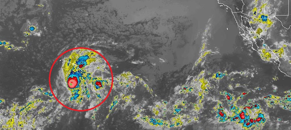
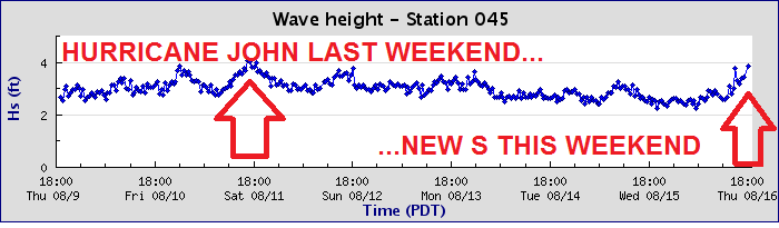
Not that I was really holding my breath waiting for the next swell, but I was starting to worry there. As mentioned in last week's THE Surf Report, the only chance we had of getting surf last week was hurricane formation- which did happen (Miriam)- but she promptly headed due W for Hawaii- and took it's swell with it.


Then Norman started to take shape yesterday and we look to be back on track (sort of). Good news is that winds are 150 mph (category 4) but it's going to move- you guessed it- (bad news) towards Hawaii. Luckily for us it's a pretty strong storm, we have some NW windswell filling in this weekend, and a touch of small SW. So long story short, we should have chest high sets late tomorrow from the combination of swells, maybe shoulder high sets on Saturday, and back to chest high for Sunday.


Water temps are still low to mid-70's, and tides this weekend are 2' at sunrise, up to 5' after lunch, and back down to 2' at sunset.

FORECAST:


Norman starts to wind down on Monday but we had a fetch of wind in the southern hemisphere pointed our way last week that will bump our surf back up to the chest high range from the S on Tuesday. That lasts into Wednesday morning.


Thursday looks small again, then another fetch of wind blew some SW swell our way for next Friday for small chest high sets. Then we get the blood pumping:


Models show a solid storm forming in the corner of Antarctica and Chile which is poised to give us well overhead S swell towards the 10th.


At the same time, hurricane Olivia may take shape too if the forecast charts hold- so along with that big S swell from the southern hemisphere- we could hit the jackpot. When it rains it pours.

WEATHER:


Great weather the past few days will continue tomorrow. Then a weak cold front to the north will kick up our clouds down here for cooler temps and more night/morning low clouds/fog for the holiday weekend. Don't get me wrong- still nice with temps in the mid-70's- but you may want to sleep in until the clouds burn off. We may get a slight warm up the 2nd half of next week (like we had today) but no hot weather or thunderstorms in sight. Make sure to keep up to date on the changing conditions at Twitter/North County Surf. 

BEST BET:
Fun waves this weekend or bigger surf around the 10th. 

NEWS OF THE WEEK:


With warm summer water comes jellyfish. Otherwise known as jellies. Or sea nettles. Or whatever you call them, the likelihood of running into these stinging tentacled creatures generally increases this time of year. But just how dangerous are these blobs of goo? I'll let the National Oceanic and Atmospheric Administration (NOAA) explain:

Jellyfish have a complicated relationship with humans: They are often feared by beachgoers because of their sting. They can get unintentionally caught up in commercial fishing nets. Some jellies can even clog intake pipes of coastal power and desalination plants, and in high concentrations, can force closures of popular beaches. For scientists, however, jellyfish are fascinating research subjects – they play important roles in the marine ecosystem and are a key source of food for some fish and sea turtles. Some even protect commercially valuable species, such as oysters, from predators. Whatever your view may be, many misconceptions exist about jellyfish. Let’s bust the Top 3 myths:


MYTH #1: Jellyfish are all the same species:
On the contrary, there are more than 200 documented species of true jellyfish (and many more of their stinging relatives) across the globe. The environmental conditions required for each species to thrive can differ. In fact, NOAA and Smithsonian Institution scientists recently found that sea nettles in the Chesapeake Bay are considerably different than those in the open ocean and recognized it as a new species.

MYTH #2: Jellyfish "go after" people:
Not true. Any contact with jellyfish is incidental. Humans are not on their menu, but when we are in their environment we can get in the way of their tentacles. While jellyfish don't have a brain, they can sense light and have coordinated swimming behaviors, which help keep them in good places to hunt for microscopic plants and fish eggs/larvae, or other prey like fish, worms, and crustaceans.

MYTH #3: Applying urine to a jellyfish sting can reduce the pain:
Perhaps the most interesting of myths, the use of urine to treat stings has been tested and proven unhelpful. A better idea? Try an acidic liquid like vinegar. There are also several commercially available products marketed for stings.

What to do if you get stung: First, look for any tentacle adhering to skin, and flush the area well with cold ocean water. Do not rub the sting area because you could inadvertently distribute the venom further into the body. Then vinegar or evidence-based commercial product should be applied if there is continuing pain.

NOAA scientists are working on a way to forecast jellyfish, using the Chesapeake Bay as a testing ground, so residents and business owners can understand the probabilities of encountering jellies based on changing environmental conditions – such as salt concentration and temperature of bay water.

How cool would that be? Having an app on your Apple Watch that when you're surfing, will alert you to jellyfish nearby. We'll probably put a human on Mars first, but still, that would be awesome.

PIC OF THE WEEK:


I love set ups like this. On small days, you surf the outer point. On big days, you surf the inner point. 6' and rippable for days on end...

Keep Surfing,

Michael W. Glenn
International Man of Mystery
Asked To Speak Next Month At Apple's Special Event
Made A SUP With Boogie Board Material, A Flex Stringer, Attached A Foil, And Use A Kite To Pull Me. I Call It The SUPoogiexoilkite. (Patent Pending)

Thursday, August 23, 2018

THE Surf Report- Early Edition


Grasping at straws. 

SURF:
Had a good start to our summer but not much since. 


Couple fun waves last Friday/Saturday but those were basically an island surrounded by flatness the past few weeks. 


The upcoming weekend unfortunately looks to be the same; just some background SW and a touch of NW windswell filling in on Friday for waist high+ surf. That will hold through Sunday. The bright spot lately is that our water is still in the mid-70's. Woohoo! 


And tides this weekend are pretty mellow; 2' at sunrise, up to 4' mid-morning, down to 2' again mid-afternoon, and up to, you guessed it, 4' at sunset. 

FORECAST:
Still no real storms in the northern and southern hemisphere lately- or on the forecast maps- so another small week of surf we're in for. 


We should get a little waist high+ bump from the NW/SW again on Tuesday and models show a small storm taking shape in the southern hemisphere in a couple days which may give us chest high surf from the S towards Wednesday. 


And if the forecast charts hold true- maybe shoulder high SW on Labor Day- because you deserve it. Until then, our only real hope again is hurricanes from the tropics, if we can just kickstart it somehow...

WEATHER:


4 weeks 'til fall and we're already starting to transition to a cooler weather pattern. Nothing dramatic, but a distinct pattern change is evolving over the Western Hemisphere as our subtropical high starts to migrate towards the East Coast, resulting in weak cold fronts moving through the West Coast (mainly over the Pacific NW). All in all, we'll have drier, cooler conditions, and more persistent night/morning low clouds/fog with air temps during the day in the mid-70's and lows in the mid 60's at night. Make sure to keep up to date on the changing conditions at Twitter/North County Surf. 

BEST BET:
Um, Labor Day, if you can wait that long. 

NEWS OF THE WEEK:


Wanted to give a quick update on Hurricane Lane since it will impact our friends in Hawaii in some capacity. Here's the latest from the National Hurricane Center (NHC) this morning:

Lane remains resilient in the face of increasing southwesterly wind shear, and remains a potent category 4 hurricane. The cloud-filled eye continues to be surrounded by a solid ring of cold cloud tops, with lightning bursts persisting in the northern eye wall for the last several hours. Current wind speeds are 125 knots (143 miles per hour).

Lane continues to make the long-awaited turn toward the northwest, and the forward speed has slowed, with the initial motion for this advisory estimated to be 315 degrees @ 6 knots. Lane has reached the western periphery of a deep-layer ridge, with a trough aloft to the northwest of Hawaii. The steering flow is relatively light and out of the south, and Lane will move northwest and north at a relatively slow speed through Friday in this environment. By 48 to 72 hours, most of the track guidance begins to show a sharp turn toward the west, as the low level circulation of Lane decouples in the face of 35 to 40 kt of shear. Exactly when this critical turn will happen is very difficult to forecast, so confidence in this portion of the track is quite low. The updated track forecast is very close to the previous but has been shifted slightly closer to the islands on days 2 and 3, when Lane will be making its closest point of approach to the islands. Beyond 72 hours, the shallow circulation of Lane is expected to be carried westward away from the islands in the low-level trade wind flow. 

Lane is beginning to move underneath increasing shear, analyzed to be near 20 kt, and latest satellite pictures indicate that this may  be finally beginning to negatively impact Lane. The shear is  expected to remain moderate for the first 24 to 36 hours, then  become quite strong beyond 48 hours. A gradual weakening trend is shown through 48 hours, with more rapid weakening beyond that time frame. The intensity forecast remains on the high end of the  guidance envelope, but follows closely all of the guidance trends that indicate significant weakening through the forecast period. 


Some notes:
1. Lane will pass dangerously close to the main Hawaiian Islands as a hurricane Thursday and Friday, and is expected to bring damaging winds. These winds can be accelerated over and downslope from elevated terrain, and will be higher in high rise buildings.

2. The slow movement of Lane also greatly increases the threat for prolonged heavy rainfall and extreme rainfall totals. This is expected to lead to life-threatening flash flooding and landslides over all Hawaiian Islands. 

3. Large and damaging surf can be expected along exposed shorelines, especially along south and west facing coasts, with localized storm surge exacerbating the impacts of a prolonged period of damaging surf.
4. Do not focus on the exact forecast track or intensity of Lane, and be prepared for adjustments to the forecast. Although the official forecast does not explicitly indicate Lane's center making landfall over any of the islands, this could still occur. Even if the center of Lane remains offshore, severe impacts could still be realized as they extend well away from the center. 
Forecast positions and max winds:
INIT  23/0900Z 16.3N 156.9W  125 KT 145 MPH
  •  12H  23/1800Z 17.2N 157.2W  120 KT 140 MPH
  •  24H  24/0600Z 18.4N 157.4W  115 KT 130 MPH
  •  36H  24/1800Z 19.5N 157.6W   95 KT 110 MPH
  •  48H  25/0600Z 20.2N 158.1W   75 KT  85 MPH
  •  72H  26/0600Z 20.4N 160.5W   65 KT  75 MPH
  •  96H  27/0600Z 20.0N 163.0W   50 KT  60 MPH
  • 120H  28/0600Z 20.5N 166.5W   40 KT  45 MPH
For the latest on the storm's potential impacts, make sure to check out the NHC updates here. 

BEST OF THE BLOG:


As you know, I'm part of a group called the North County Board Meeting. No, it's not a cult, but we are highly devoted to surfing. The purpose is to build our community by supporting local businesses, charitable work, networking, and catching a few waves while we're at it. Since we'll have a little waves tomorrow (and our water temps are north of 70 degrees), we'll be having one of our world famous Surf Meetings. Happening from 7-9 AM, we'd like you to come on down to Seaside to catch a wave before work, grab some breakfast, network, get the scoop on our next charity event, and just start the weekend right. Look for the green tent and the demo boards from SUPERbrand! For more info, contact me at northcountyboardmeeting@gmail.com or check out our website here. Hope to see you there!

PIC OF THE WEEK:


Not the biggest, but I'll take it right about now. 

Keep Surfing,

Michael W. Glenn
Lofty
Finally Got My Own Wikipedia Page! 
Redefining High Performance Surfing. Again. 

Thursday, August 16, 2018

THE Surf Report- Early Edition


Welcome back May Gray! 

SURF:


And just like that- the May Gray we were missing in May- shows up in August. Boy is our weather out of whack. Nice to have some cool temps though in August. 


As far as our surf went the past few days, we a couple rideable waves show up yesterday in the form of a new S swell- and luckily for us- that will continue to build tomorrow and peak mid-day Friday. Look for chest high+ surf around town and shoulder high+ sets in the OC. Not the biggest but still fun. Saturday will have leftover chest high surf and Sunday will drop to the waist high+ range. Water temps if you haven't noticed, have dropped to the low 70's due to our cloud cover and lack of a heat wave this week. Still good enough for trunks and a jacket. 


And tides this weekend are pretty mellow; between 2-3' at sunrise, up to 5' late afternoon, and back down to 3' at sunset. 

FORECAST:

As I mentioned in last week's THE Surf Report, the southern hemisphere was on lock down and our only real shot of surf in the near future was going to be from the tropics. Well, Hurricane Lane formed a couple days ago but promptly headed due W to Hawaii (can't really blame him). So in regards to this week's long range forecast, the southern hemisphere is still napping and our only short term shot at waves is from the tropics again. If anything is to form, it won't be for at least 4 or 5 days and we'd get some hurricane surf about 4 days after that. IF, something materializes. So long story short, just look for background knee to waist high SW with NW windswell until at least the 25th of August UNLESS a hurricane forms. And that's a big unless. That doesn't make sense. Confused? So am I. Long story even longer- look for small waves all next week.  

WEATHER:


Nothing too exciting in the way of weather this coming week- except for the lightening visible in our inland valleys tonight. That subsides over the weekend and here at the coast we have night/morning low clouds/fog being replaced by afternoon sunshine. Temps will hit high 70's during the day and high 60's at night. The only real action next week is more thunderstorms in the mountains/deserts but models don't show those making it to the coast. So until then, pretty quiet around here until that supposed El Nino hits this winter. Make sure to keep up to date on the latest conditions at Twitter/North County Surf. 

BEST BET:
Friday. And then that's it. Forever. Or until a hurricane forms. 

NEWS OF THE WEEK:


Even though our water temps have dropped slightly to the mid to low 70's, we're still warmer than average by a few degrees this time of year. Is El Nino to blame? Maybe. The biggest culprits though were that we had above normal air temperatures in July and August as well as the lack of a normal WNW sea breeze. The lack of WNW winds didn't cause any cold upwelling along the CA coast, so the water pooled up along our shores and continued to heat like a bath to a balmy 80 degrees. But did El Nino even contribute slightly? Maybe. According to the National Oceanic and Atmospheric Administration, we're right on track for at least a mild El Nino this winter. Oh boy. Here's what they had to say recently:

By nearly all measurements, forecasters expect our old buddy El Niño will have a 60% chance of appearing this fall, rising to 70% by winter, and the El Niño Watch issued at the beginning of summer continues...


The latest weekly water temp readings in our ever important Niño3.4 region (basically below Hawaii and towards Latin America) were about 0.2 degrees Farenheit above the long-term average. Doesn't seem like much until you realize that we're coming out of a cold La Nina and the El Niño threshold is just 0.9 degrees. The 0.2 degrees is actually a little bit lower than the previous few weeks, but it doesn’t mean that El Niño is less likely. El Niño is a seasonal phenomenon, meaning it’s an average pattern that lasts several months in a row. Weekly fluctuations are expected, and we don’t base our assessments on short-term trends like weekly changes in sea surface temperatures.

The other temperature indexes we follow in the equatorial Pacific are also near normal or slightly above. This includes weekly values of 0.75 degrees above normal in the Niño4 region, 0 in Niño3, and 0.25 in Niño1+2. 

So the surface water temps are neutral or slightly above average; what about the all important deep water readings? Well, subsurface heating is still elevated. The temperature under the central-eastern Pacific (between the date line and 100°W longitude, and ~1000 feet deep up to the surface) was 1.5 degrees Farenheit above the long-term average during July- which is a lot of energy to feed into storms this winter.


The surface winds over the tropical Pacific are very important during the development phase of El Niño. This means conditions in the ocean affect the atmosphere, and vice-versa. The normal atmospheric circulation over the Pacific is driven by warm air rising over warm water near Indonesia, west-to-east winds aloft, descending air in the eastern Pacific, and returning east-to-west winds near the surface. Those east-to-west winds help to keep warm water trapped in the far western Pacific, continuing the cycle, and possibly feeding our storms this winter. 

During a full-fledged El Niño event, the change in this relationship is clear, and consistent: the warmer-than-average water in the east-central Pacific causes more rising air over that region, changing the circulation from its average pattern. The near-surface east-to-west winds weaken, and may even reverse so they’re blowing from west-to-east, allowing warmer waters to build in the central Pacific.

When El Niño is developing, though, short-term fluctuations in the near-surface winds can have substantial effects. A period of weaker trade winds can help build El Niño’s warmer surface waters, while a period of stronger trade winds can cool the surface and impede El Niño’s growth. It appears that the trade winds are currently weakening (i.e. good), and may continue to do so through the next week, likely helping push things in the El Niño direction.


The latest computer models continue to predict that the sea surface temperature in the Niño3.4 region will cross the El Niño threshold (0.9°F above the long-term average) sometime in the fall. Both the statistical and dynamical computer models generally agree, adding some confidence to the ENSO forecast.

So there you have it. Our water temps may be elevated through the winter which means:
  • Trunks into October?
  • Only a 3/2 this winter instead of a 4/3?
  • More rain hopefully?
  • And solid surf! Jinx! 
PIC OF THE WEEK:


Peru is famous for:
  • Machu Picchu
  • The weather phenomenon El Nino was first named here 
  • Pro surfers Miguel Tudela, Sofia Mulanovich, Felipe Pomar, and Gian Carlos
  • Llamas! 
  • The Andes mountains
  • The first known surfers
  • Alpacas! 
  • The highest navigable lake in the world, Lake Titicaca
  • Cotahuasi Canyon, the world's deepest at 10,605 feet
  • The Atacama desert, which in some parts have only received 1 inch of rain in 30 years
  • And loooooooooong left points. 
I may have to retire down there. 

Keep Surfing,

Michael W. Glenn
The W. Stands For 'Wow'
Caffeine Free
What Do You Call the Last Wave of Your Session? A Wave Goodbye. (I Made That Up. I Got A Million Of 'Em)

Thursday, August 9, 2018

THE Surf Report- Early Edition


HI comes to CA.

SURF:


Not an impressive week for surf but definitely for the water temps. 


Multiple locations had readings of 80 and above- and I'm not talking about Hawaii either- I'm talking about Camp Pendleton to La Jolla. Along with the tropical clouds overhead, it made the small surf bearable. 


As luck would have it, Hurricane John flared up early in the week just south of Cabo and chest high sets started showing tonight in North San Diego County and shoulder high in the OC. John unfortunately wasn't as big as originally anticipated- and he died once he hit our swell window- but we still should have shoulder high sets in far North San Diego County tomorrow and head high waves in the OC. 


By Saturday John is leaving town but on Sunday we have a new pulse from the southern hemisphere for more chest high+ SW. All in all a fun weekend of surf. 


Beware the tides this weekend! Look for 0' at sunrise, up to 4.5' mid-morning, down to 1' late afternoon, and up to 5.5' at sunset.

FORECAST:
The SW mentioned above on Sunday rolls into Monday for more chest high waves. 


Tuesday is a transition day then we get more S swell from Antarctica late Wednesday into Thursday. Nothing big but more fun chest high surf. After that, models show the southern hemisphere taking a rest which leaves the waters off mainland Mexico and hurricane production our only source of swell for the 3rd week of August. 

WEATHER:


If you haven't noticed already, it's hot. Nights, mornings, mid-days; doesn't matter. It's hot. Normally our cool ocean waters (like 70 degrees) help us cool down at night. But since the ocean has been 80 degrees lately, our nights don't cool down at all. Like San Diego; it was 77 degrees. At 4 AM. Incredible. Our weather this weekend cools slightly- mid-80's during the day and 70 at night with a few tropical clouds overhead. Early next week the late night/early morning low clouds may make a slight return and our temps may even cool to 75 late in the week (during the day- nights thankfully should be high 60's), but then models show high pressure returning by next weekend for more heat and tropical clouds. Make sure to keep up to date on the latest conditions Twitter/North County Surf.  

BEST BET:
Pretty much tomorrow through Thursday. Saturday and Tuesday may dip slightly but we'll have great weather and warm water regardless. 

NEWS OF THE WEEK:


Here's news that you probably knew already (or at least figured it out on your own), but it's worth repeating. Due to our extremely warm water lately, the San Diego Union Tribune reported this week that our potential for hurricanes in San Diego is the greatest it's been in over a century. Why you ask? Well, the minimum water temperature needed for hurricane formation is 80 degrees, and we've been toying with that for the past couple weeks. Now of course you need a large area of 80 degree+ water and we've just got a small pool of it here in San Diego County, but if one forms off Baja, it would have an easier time maintaining it's strength and travelling up the coast, instead of dying once it hits our normally cooler waters. Here's what the Union Tribune had to say:

Ocean temperatures are the highest they have ever been in San Diego, scientists said. This is causing the potential of a hurricane to sweep through the area for the first time in over 160 years. Record high temperatures were first noticed at the beginning of August. Water temperature testing has been conducted at the end of Scripps Pier in La Jolla, every single day since 1916. On Wednesday, August 1, water samples showed a reading of 78.6 degrees Fahrenheit. Researchers said it broke an all-time record.


“Under these conditions, the hurricanes that form in the southeast Pacific have a higher chance of tracking more northward and potentially affecting us," Said Art Miller, Ph.D., head of the Oceans and Atmosphere Section of the Scripps Institution of Oceanography. Miller added the chances a hurricane would directly hit San Diego are slim, however, it could drift upwards from Baja California as the unusually warm ocean waters in the area fuel it. “As it migrates more towards the north, it has the potential to keep its dynamic structure and produce rainfall events," added Miller. 

A tropical storm can be classified as having wind speeds of 39-73 miles per hour. A hurricane has wind speeds of 74 mph or greater. There has only been one hurricane in recorded history in California. It is known as the 1858 San Diego hurricane. There have been multiple tropical storms to hit San Diego. For example, in 1976, Hurricane Kathleen moved from the south into the county as a tropical storm. A year later in 1977, Hurricane Doreen was considered the worst tropical cyclone to hit California in over 30 years, causing an estimated $25 million in damage. 

"Since 2014, we’ve had a lot of warming in the Pacific," said Melissa Carter, a programmer analyst with the Scripps Institution of Oceanography. "We also have a lot of water coming up from the south, which is warmer." Miller added the wetter and warmer weather could bring about a destructive El Niño weather pattern in 2018-2019 as well. So get that Rhino Chaser ready people! 

PIC OF THE WEEK:


You've probably heard of all the famous people that have bought their own islands. Richard Branson, Johnny Depp, Marlon Brando, Nicholas Cage, Leonardo DiCaprio, Mel Gibson, and my personal favorite- Celine Dion. But do any of them surf? Of course not. If they did, they would have bought this priceless gem years ago. Lucky for you and I, it's still available. Just need to win that Powerball thing. 

Keep Surfing,

Michael W. Glenn
Out of This World
Boy Bands Are So 2000's. I'm Starting A Mid-Life Crisis Band
Best Surf Forecaster Ever!* (*According To My Mom)

Thursday, August 2, 2018

THE Surf Report- Early Edition


Really?

SURF:


Ok- don't be hatin'- but here goes: Got a new board earlier this week. It's a 5'4" groveler (SUPERbrand Tazer- sorry- shameless plug) made for knee high surf. Ask me if I've ridden it yet. Nope. Surf went DEAD flat the past few days. Typical. Remember the step-up I got for solid winter surf? Yep- the waves never went above head high for 15 straight weeks. 


So I thought I'd trick Mother Nature and get a small wave board instead. No way it could go completely flat, right? Jinx! So we're on day 5 now of 'Swell Watch'. I'll let you know when I get to ride it. 


Now before you go storming the castle with your pitchforks and torches, we did have a small bump in the southern hemisphere last week that should start to pick up our surf tomorrow- to the waist high range late in the day- and maybe a chest high set towards the OC on Sunday. 


We also get a little boost from NW windswell late Saturday as our high pressure starts to break down, so surf around town may be fun later this weekend from the small combo swells. All in all, look for the surf to start out flat this weekend and get rideable by Sunday. 


Water temps as you know are an incredible 75-79 degrees and tides this weekend are about 1.5' in the morning, up to 5' late afternoon, and down to 3' at sunset. 

FORECAST:
After the little combo swell on Sunday, surf drops to the waist high range early in the week. 


Charts showed a small storm flaring up off Antarctica today that should give us chest high SW late next Wednesday into Thursday. 


That storm is forecasted to rebuild into a stronger system this weekend that would give us shoulder high sets around Sunday the 12th. 


And if the models are right, we'll get a head high S swell from the southern hemisphere again towards the the 15th. That storm is still a few days away from forming so make sure to keep up to date on the latest conditions at Twitter/North County Surf.  As far as any hurricanes go, it's been bleak lately. We have a storm trying to gain strength this afternoon between us and Hawaii- but it's headed to Hawaii. Charts show 1 or more storms taking shape about a week out- but they may be headed to Hawaii too. Hopefully they take a turn for the better. 

WEATHER:


Our hot and muggy conditions will take a break this weekend as the cold front mentioned above breaks down our high pressure and the night/morning low clouds/fog return tomorrow. Our beach temps in the mid-80's will drop to the mid-70's by Saturday. Brrrrr. Sunday is a transition day then, yep, you guessed it, high pressure and the tropical moisture make a return next week for more thunderstorms in the mountains/deserts and humid conditions at the beaches with temps back to the low 80's. Why buy a ticket to Tahiti when it's in your own backyard?! 

On a side note, I'm still amazed at the extremes we have in California. Take our sister cities Ocean Beach as an example- one is in San Diego and the other San Francisco. Ocean Beach San Francisco today was in the low 60's today while on the flip side, Ocean Beach San Diego was in the low 80's. There is also a 20 degree difference in the ocean temps with Ocean Beach San Francisco hitting a chilly 58 degrees and Ocean Beach San Diego- you guessed it- 78 degrees. Glad I live down here! And for you true weather aficionados- Bodie, CA in the central Sierras last night was 40 degrees while Death Valley to the south was 120 degrees during the day. A massive 80 degree difference just a few hours away. What does this all mean? Not sure really, but thanks for reading.   

BEST BET:
Sunday or next Thursday with a little bump in SW swell OR... wait for bigger surf mid-month and the chance for more hurricanes?

NEWS OF THE WEEK:


Our hurricane season started off with a BANG in May and now has gone eerily silent. What looked to be a banner year for hurricane surf is turning out to be pretty average. There's still hope since we're right in the middle of the season but I'm surprised how quickly the spigot was turned off- considering we had the following already:
  • Name                 Dates         Max Wind (mph)
  • ---------------------------------------------------
  • TD One-E           10-11 May           35
  • MH Aletta            6-11 Jun            140
  • MH Bud               9-15 Jun           130
  • TS Carlotta         14-18 Jun            65
  • TS Daniel           24-26 Jun            45
  • TS Emilia            27 Jun- 2 Jul       60
  • H  Fabio              30 Jun- 6 Jul      110
  • TS Gilma             26-29 Jul            40
  • TD Nine-E           26-27 Jul            35
  • TS Hector            31 Jul-                45
Considering we've had 2 major hurricanes in early June alone, things were looking up. And then for reasons unknown, nothing of substance for almost a month. Here's a quick synopsis from the National Hurricane Center: 


Tropical cyclone activity in the eastern Pacific basin in July was below average. Only two named storms (Fabio and Gilma) formed during the month, with Fabio becoming a hurricane. Two tropical depressions also formed during the month.  Even though Tropical Depression Ten-E formed at the end of July, it strengthened into Tropical Storm Hector on August 1 (and was moving away from us resulting in no swell for southern CA). Based on a 30-year (1981-2010) climatology, three to four named storms typically form during July, with two of those becoming a hurricane and one of those reaching major hurricane intensity. In terms of Accumulated Cyclone Energy (ACE), which measures the strength and duration of tropical storms and hurricanes, activity in the basin so far in 2018 is near average.


As far as water temperatures from here to Baja go, there's plenty of warm ocean to fuel hurricanes. Heck- we're even close to 80 degrees here in San Diego which is about the threshold to feed a hurricane. (And for those of you keeping score, that's 5-9 degrees above average).As mentioned in the FORECAST above, a couple hurricanes may flair up between now and the 9th, but they may be headed to Hawaii. Let's keep our fingers crossed or rub that lucky rabbit's foot or find a 4 leaf clover or pray they end up coming our way. Whatever it takes to get us back on track! 

PIC OF THE WEEK:


I bet my new 5'4" would work so good in those waves. Guess I'll have to wait. (sniff)

Keep Surfing,

Michael W. Glenn
Commander
Some People Call Me The Space Cowboy
Building a Surf Theme Park Called Shredderland With A 50' Mavericks-like Wave Pool Stocked With Great Whites