Thursday, March 31, 2022

THE Surf Report


Hope You Have Your Rhino Chaser Ready...

SURF:

If the models are correct, we may see our biggest swell in 10 years- if not 20- headed our way next week. Or it could be an early April Fools joke. Pretty sure it's an April Fools joke. 


In all seriousness though, we did have plenty of surf the past week BUT... spring time conditions made finding a clean window a bit tricky. 


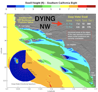
For Friday, look for cleaner conditions and leftover NW windswell and peaking SW groundswell for chest high surf. Saturday drops just a touch but we'll still have nice weather. 


For Sunday, we get an uptick in NW swell again- but another weak front will move through for questionable conditions. And here's the tides, sun, and water temps for the next few days:
  • Sunrise and sunset:
    • 6:34 AM sunrise  (paddle out at 6:15 AM?)
    • 7:10 PM sunset  (paddle in at 7:30 PM?)
  • Water temps are in the low 60's.
  • And here's the tides for this weekend:
    • 1' at sunrise
    • 4' before lunch
    • 0.5' late afternoon
    • and up to 1' at sunset
FORECAST:

We SHOULD have good weather next week and that will help out in the surf department. 


Monday starts off with more fun sized NW (chest high sets) while Tuesday sees more chest high SW swell filling in. The rest of the week looks to have fun combo SW/NW in the waist to chest high range. 


Late next weekend, models hint at good SW again for chest high+ surf...

and MAYBE solid NW too. Could turn on the EBS if the weather cooperates (more on that below). 


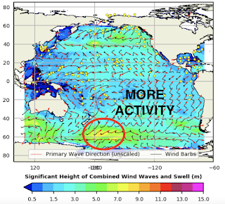
And then... a solid SW towards the 12th? It is SW swell season you know...

WEATHER:


Not a bad storm earlier in the week with most spots receiving 3/4" of rain along the coast and up to 1"+ in the hills. Big Bear even saw 4-6" of snow; pretty good for spring. We've got weak front moving through tonight for a chance of light showers then back to sunny skies Friday/Saturday and mild weather. Another weak front will swing through on Sunday for cloudy skies- and no real chance of precipitation. Next week should be nice but we could have some weak fronts move through again late in the week. Think 'typical spring weather'. If anything changes between now and then, make sure to follow North County Surf on Twitter!

BEST BET:

Pretty much the next 7 days with small but fun combo swell. OR... the 10th to 15th timeframe with bigger NW/SW swells IF the models hold up.

NEWS OF THE WEEK:


Good to see rain earlier in the week. Most locations along the coast are now approaching 7 total inches for the season. But as we head towards summer, the chance of a good storm adding to our totals diminish considerably. Our annual rainfall is around 10-11", so it looks like another year of drought around here. Conserving water will be of utmost importance again this summer for households. But what if the aqueducts that supply us can also conserver water- and as a byproduct- produce clean energy? Here's Fast Company magazine with a solution: 

Mounting evidence suggests the western United States is now in its worst megadrought in at least 1,200 years. Groundwater supplies are being overpumped in many places, and the dryness, wildfires, and shrinking water supplies are making climate change personal for millions of people.

About 4,000 miles of canals transport water to some 35 million Californians and 5.7 million acres of farmland across the state. In a 2021 study, covering these canals with solar panels would reduce the evaporation of precious water—one of California’s most critical resources—and help meet the state’s renewable energy goals, while also saving money.

The first prototypes in the U.S. for both wide-span and narrow-span canals are now in development in California’s Central Valley. Researchers at the University of California, Merced, are involved in the project, and we will be trying to determine how this can become a large-scale solution.

CONSERVING WATER AND LAND
California is prone to drought, and water is a constant concern. Now, the changing climate is bringing hotter, drier weather. Severe droughts over the past 10 to 30 years dried up wells, caused officials to implement water restrictions, and fueled massive wildfires.

At the same time, California has ambitious conservation goals. The state has a mandate to reduce groundwater pumping while maintaining reliable supplies to farms, cities, wildlife, and ecosystems. In October 2020, as part of a broad climate change initiative, Governor Gavin Newsom directed the California Natural Resources Agency to spearhead efforts to conserve 30% of land and coastal waters by 2030.

Most of California’s rain and snow falls north of Sacramento during the winter, while 80% of its water use occurs in Southern California, mostly in summer. That’s why canals snake across the state—it’s the largest such system in the world. We estimate that about 1% to 2% of the water they carry is lost to evaporation under the hot California sun.

In that 2021 study, we showed that covering all 4,000 miles of California’s canals with solar panels would save more than 65 billion gallons of water annually by reducing evaporation. That’s enough to irrigate 50,000 acres of farmland or meet the residential water needs of more than 2 million people. By concentrating solar installations on land that is already being used, instead of building them on undeveloped land, this approach would help California meet its sustainable management goals for both water and land resources.


CLIMATE-FRIENDLY POWER
Shading California’s canals with solar panels would generate substantial amounts of electricity. Our estimates show that it could provide some 13 gigawatts of renewable energy capacity, which is about half of the new sources the state needs to add to meet its clean electricity goals: 60% from carbon-free sources by 2030 and 100% renewable by 2045.

Installing solar panels over the canals makes both systems more efficient. The solar panels would reduce evaporation from the canals, especially during hot California summers. And because water heats up more slowly than land, the canal water flowing beneath the panels could cool them by 10 degrees Fahrenheit, boosting production of electricity by up to 3%.

These canopies could also generate electricity locally in many parts of California, lowering both transmission losses and costs for consumers. Combining solar power with battery storage can help build microgrids in rural areas and underserved communities, making the power system more efficient and resilient. This would mitigate the risk of power losses due to extreme weather, human error, and wildfires.

We estimate that the cost to span canals with solar panels will be higher than building ground-mounted systems. But when we added in some of the co-benefits, such as avoided land costs, water savings, aquatic weed mitigation, and enhanced PV efficiency, we found that solar canals were a better investment and provided electricity that cost less over the life of the solar installations. And this is before factoring in the human health benefits of improved air quality and reduced greenhouse gas emissions.

BENEFITS TO THE LAND
To be clear, solar canals are about much more than just generating renewable energy and saving water. Building these long, thin solar arrays could prevent more than 80,000 acres of farmland or natural habitat from being converted for solar farms.

California grows food for an ever-increasing global population and produces more than 50% of the fruits, nuts, and vegetables that U.S. consumers eat. However, up to 50% of new renewable energy capacity to meet decarbonization goals could be sited in agricultural areas, including large swaths of prime farmland.

Solar canal installations will also protect wildlife, ecosystems, and culturally important land. Large-scale solar developments can result in habitat loss, degradation, and fragmentation, which can harm threatened species, such as the Mojave Desert tortoise.

They also can harm desert-scrub plant communities, including plants that are culturally important to Indigenous tribes. As an example, construction of the Genesis Solar Energy Center in the Sonoran and Mojave deserts between 2012 and 2014 destroyed trails and burial sites and damaged important cultural artifacts, spurring protracted legal conflict.

CLEARING THE AIR—AND THE WEEDS
By generating clean electricity, solar canals can improve air quality. Another benefit is curbing aquatic weeds that choke canals. In India, where developers have been building solar canals since 2014, shade from the panels limits growth of weeds that block drains and restrict water flow.

Fighting these weeds is expensive, and herbicides threaten human health and the environment. For large, 100-foot-wide canals in California, we estimate that shading canals would save about $40,000 per mile. Statewide, savings could reach $69 million per year.


BRINGING SOLAR CANALS TO CALIFORNIA
California’s aging power infrastructure has contributed to catastrophic wildfires and multiday outages. Building smart solar developments on canals and other disturbed land can make power and water infrastructure more resilient while saving water, reducing costs, and helping to fight climate change.

Turlock Irrigation District, in California’s San Joaquin Valley, will build the first solar canal prototype in partnership with project developer Solar Aquagrid, researchers, and others supported by the state Department of Water Resources.

The prototypes in this mile-long demonstration project, along with future pilots, will help operators, developers, and regulators refine designs, assess collective benefits, and evaluate how these systems perform. With more data, we can map out strategies for extending solar canals statewide, and potentially across the entire West.

Sounds like a win-win for everyone. Now we just need to find a way to squeeze more rain out of the clouds. 

BEST OF THE BLOG:


It’s almost time for the North County Board Meeting’s annual-ish golf tournament at Goat Hill Park in Oceanside on Friday, May 13th! And we’re proud to announce the beneficiary of this year’s event is Folds of Honor. Folds of Honor provides scholarships to spouses and children of America’s fallen and disabled service members. (You can learn more about them here).

We’re filling up fast on spots to play and sponsor holes. If you haven’t already, please make sure to either:
  • Make a check payable to North County Board Meeting and send to Alliance Multimedia, 2033 San Elijo Ave #230, Cardiff, CA 92007 or…
  • Contact Rich Clark at Fuzion Payments for credit card payment at rclark@fuzionpayments.com
Since this is a charitable event, we hope you understand that it’s ‘1st come, 1st serve’; we can’t hold spots or take IOU’s. Cost again is just $100 to play and includes lunch. And hole sponsorship is only $200 and is a great way to bring awareness of your company to the local community.

And besides playing or sponsoring a hole, there are other ways you can help; we are also looking for raffle prizes and goodies for the swag bags. If you’d like to assist or have any other questions, please reach out to Michael at northcountyboardmeeting@gmail.com. Thanks for the support and we’ll see you on May 13th!

PIC OF THE WEEK:


I know I'm biased, but here's a debate I throw at my friends from time to time: Name a better stretch of coast for surfing than north county San Diego. With just a short drive to Blacks in the south and Lowers to the north, there's point breaks, beach breaks, reef breaks, and river mouths in between. You can even trunk it in summer and the beaches pick up swells from every direction. Sure the North Shore of Oahu is the mecca of surfing- but what do you do in the summer? Surf Waikiki?! It'll take you hours in traffic just to get there! How about the Gold Coast you say? Also plagued with just 1 season- plus there's 38 million surfers (give or take 10 million). And I don't want to hear "Now you've let everyone in on our secret!!!" Umm, have you seen home prices lately? Too late. So the next time the surf looks 'small' or 'blown out' in north county and you're debating if you should drive home- just paddle out- you don't even know how good you got it. 

Keep Surfing, 
Michael W. Glenn
Fairest Of Them All
Float Like A Bee, Sting Like A Butterfly
My Board Has Retractable Fins So I Can Switch Between Tri Or Quad During A Turn

Thursday, March 24, 2022

THE Surf Report


Sumter Is Now My Favorite Season.

SURF:

What season do you call 80 degree air temps one day then a windy/wet/cold 1" of rain the next? Sumter! Get it? Summer + Winter! Or is it Winmer?! Anyway, it sure isn't Spring. 


Great summer-like weather this past week slowly transitioned to cooler temps today and the return of fog. And late Sunday into Monday? A solid winter storm for spring! So enjoy then semi-clean conditions this weekend while you can. 


As far as the surf goes, we had new NW filling in today for chest high sets and new SW fills in tomorrow for more chest high sets. Saturday looks to be the same and Sunday could be suspect with the impending storm- but we will have building NW late in the day. Best bet is to get it early Friday or Saturday. And here's the tides, sun, and water temps for the next few days:
  • Sunrise and sunset:
    • 6:44 AM sunrise  
    • 7:05 PM sunset  
  • Water temps are in the low 60's.
  • And here's the tides for this weekend:
    • 4' at sunrise
    • -0.7' at lunch
    • and 3.5' at sunset
FORECAST:


As mentioned above, we have a storm rolling through on Monday for overhead surf and junky conditions. On Tuesday, things start to clean up- except for the water. 


Wednesday still has leftover waist high NW and building chest high sets from a new SW. For Thursday, charts show more head high NW (EBS anyone?) and that lasts into Friday. Next weekend will have leftover small combo swell. 


Further out, charts show good NW around April 4th and good SW around April 6th. In summary- plenty of surf next week ONCE the storm leaves early in the week. 

WEATHER:


Winter has decided to show up a week late but I'll take it. Let's start with tomorrow first- looks like nice weather once the low clouds burn off and Saturday will be the same. Sunday should be cloudy all day and showers at night. Monday is forecasted to have up to an inch of rain and windy conditions then cleaner, breezy conditions as it exits on Tuesday. This storm looks to be solid- one of the better ones we've had this season. The 2nd half of the week looks to be sunny and cool (kind of like my disposition). If anything changes between now and then, make sure to follow North County Surf on Twitter!

BEST BET:

Mid-week with fun combo swell and cleaner water. Or if the models are correct- good NW 4/4 or good SW 4/6. 

NEWS OF THE WEEK:


And the results are in: The average temperature on Earth for the warmest February on record was 7th place last month! Which, in the Olympics or any other sporting event wouldn't be that great. But when you're talking about rising temperatures in relation to heat and drought, I'll take 7th. According to the National Oceanic and Atmospheric Administration (NOAA), our planet continued its relatively warm start to 2022, with February ranking as the seventh-warmest February in the climate record.

Last month also wrapped up an extremely warm December to February season for the planet, according to scientists from NOAA’s National Centers for Environmental Information. Here’s more from NOAA’s latest monthly global climate report:

Climate by the numbers:

February 2022 | Season (December 2021 – February 2022)

The February global land and ocean surface temperature was 1.46 degrees F (0.81 of a degree C) above the 20th-century average, ranking as the seventh-warmest February in the climate record.

Regionally, Asia, Europe and South America saw average temperatures that ranked among their eight-warmest Februaries on record. North America was the only continent to have a below-average February temperature.

Looking at the three-month season, the global surface temperature was 1.51 degrees F (0.84 of a degree C) above the 20th-century average of 53.8 degrees F (12.1 degrees C), tying with 2015 as the world’s fifth-warmest such period on record. 

December through February was also the Northern Hemisphere’s sixth-warmest meteorological winter and the Southern Hemisphere’s seventh-warmest meteorological summer on record.


Other notable takeaways from the report:

Polar sea ice was scant. Antarctic sea ice extent (coverage) for the month was the smallest on record — 830,000 square miles (29.6%) below average — surpassing the previous smallest February extent set in 2017. The February 2022 Arctic sea ice extent was 4.5% below average and the 14th-smallest February extent in the 44-year record.

A warm start to 2022 so far. The year-to-date (January and February) global surface temperature was the sixth highest on record. According to NCEI’s Global Annual Temperature Rankings Outlook, it is virtually certain (> 99.0%) that 2022 will rank among the 10-warmest years on record.

Tropical cyclone activity saw a significant uptick. The globe had an above-average number of tropical cyclones in February, with a total of eight named storms, four of which intensified to become hurricanes (also known as cyclones or typhoons in parts of the Eastern Hemisphere). The South Indian Ocean was the most active ocean basin with five named storms, tying with February 2000 and February 2007 for the most named storms since 1981.

Just think on the bright side- by 2030 our ocean temps will be so warm that we'll never have to wear a fullsuit again in California!

PIC OF THE WEEK:


Pretty sure this is the lost island of Atlantis. 

Keep Surfing, 
Michael W. Glenn
Wondrous
Still Have A Perfect Bracket
Been Hiding Out With DB Cooper, Jimmy Hoffa, Amelia Earhart, and Miki Dora

Thursday, March 17, 2022

THE Surf Report


Luck Of The Irish. 

SURF:

Boy were we lucky this week. 


Heaps of surf and great weather resulted in firing waves up and down the coast. 


For tomorrow, the NW we've been enjoying will be a shell of it's former self but we do have a new fun SW filling in on Saturday as well as NW windswell from a cold front moving down the coast. Look for fun chest high combo surf later in the day. 


For Sunday, forecast models the past few days have been showing a windy cold front hitting So-Cal and the surf should be a mess. Not much rain with this system but it will be bumpy in the line ups. And here's the tides, sun, and water temps for the next few days:
  • Sunrise and sunset for Saturday:
    • 6:53 AM sunrise  
    • 7:00 PM sunset  
  • Water temps have warmed slightly to 62. Is winter officially over? Jinx! 
  • And we've got a fair amount of tides this weekend:
    • 3' at sunrise
    • 5' late morning
    • 0' late afternoon
    • 2' at sunset
FORECAST:

Once the storm exits on Sunday, Monday looks to be fun with dropping shoulder high NW and a touch of leftover SW- and clean conditions. May have to flip on the ol' EBS. Tuesday/Wednesday look to be transition days with small SW/NW. 


Later in the week, we've got more fun SW building towards Thursday into Friday with chest high sets in N SD County and shoulder high waves in the OC. Models show more storms off Antarctica trying to take shape but nothing concrete yet. Regardless, we're heading towards SW swell season. 


Also on Friday, we have more shoulder high NW filling in. Along with the SW swell- could be fun. May have to flip on the ol' EBS- again. As long as the weather cooperates next week, we should have fun surf Monday and Friday. 

WEATHER:


Know what the last day of winter is? Correct, March 20th. And the atmosphere is going to give us one last gasp of cold blustery weather. Friday looks to be the last nice day this week before Saturday transitions to more clouds and Sunday is breezy with just a chance of showers- at most 1/10". Next week high pressure is in control and we're back to temps in the low 70's during the day and low 50's at night. If anything changes between now and then, make sure to follow North County Surf on Twitter!

BEST BET:

Monday with clean combo swell or next Friday with clean combo swell! 

NEWS OF THE WEEK:


Just when I though La Nina (lack of rain, colder than usual ocean temps) was fading away- looks like it may be overstaying its welcome! Welcome to summer in a fullsuit! Here's the latest from the National Oceanic and Atmospheric Administration (NOAA):

Three Pack:
All good things come in threes. Well, depending on your opinion of La Niña, maybe not all good things, as La Niña—the cool phase of the El Niño-Southern Oscillation climate pattern—reasserted itself in the tropical Pacific this past month with some of the strongest atmosphere-ocean coupling of our double-dip La Niñas so far (winters of 2020-21 and 2021-22). La Niña is now favored to continue into the Northern Hemisphere summer 2022, with nearly equal chances of ENSO-neutral or La Niña thereafter. Is a La Niña three-peat in the offing? 

Three-dimensional


Wait- La Niña strengthened in February? It did, despite the fact that sea surface temperatures in the key monitoring region of the tropical Pacific, the Niño-3.4 region, appear to have bottomed out in December, with a monthly value of -1.1°C (ERSSTv5 data set). Since then, the monthly values have warmed slightly, though February 2022 remained chilly at -0.9 °C. However, the February average smoothed out some notable variability: the weekly average Niño-3.4 index was -0.6 °C at the beginning of February and then decreased to -1.1 °C in the past week. Quite a dive! 

Confused by all the numbers for presumably the same Niño-3.4 sea surface temperature index? Don’t be- averages for shorter time spans can fluctuate around a lot more than longer averaging periods. This is the difference between weather and climate. Day-to-day or week-to-week weather can change a lot relative to monthly and longer seasonal climate averages, which do not vary as much. Even as the weekly and monthly values have jumped around, the Oceanic Niño Index (ONI), NOAA’s official measure of ENSO, has remained constant at -1.0°C for the third, overlapping season in a row.

One of the major challenges in ENSO prediction is trying to untangle meaningful seasonal swings in the tropical climate from the shorter-term noise of tropical weather. In February, along with cooling off of sea surface temperatures, we saw a stronger Pacific Walker circulation: a strengthening of trade winds along the surface of the equator (blowing from east-to-west), stronger winds in the upper tropical atmosphere (that blow from west to east), significant drying over the Date Line, and increased rainfall anomalies over the Maritime Continent. All of these features are consistent with a healthy La Niña.

In fact, by some of our atmospheric measures—the Equatorial Southern Oscillation Index and Central Pacific Outgoing Longwave Radiation index (a measure of equatorial rainfall)—we saw some of the largest monthly values dating back to the start of the first La Niña event in the autumn of 2020! The Pacific Walker circulation was clearly juiced up in the past month and is probably why we saw weekly Niño-3.4 sea surface temperatures take a tumble.

With that said, one month doesn’t make an entire season, and it may have been a short-term swerve on the road to the dissipation of La Niña, as it typically does, through the spring and summer. It’s enough to have at least slowed down La Niña’s exit from the global climate stage, but does it portend more meaningful change going forward? We’ll get back to that later.

Three-legged Race


What does the continuation of La Niña mean for impacts during the March-May season over the contiguous United States? As regular blog readers know, the two biggest drivers of seasonal climate outlooks are ENSO and climate trends. 

As one might expect, NOAA CPC’s official seasonal outlooks for March-May 2022 resemble the patterns above with some exceptions. In general, above-average temperatures are favored over a large part of the contiguous U.S., with the exception of the northwestern U.S., where below-average temperatures are more likely. Above-median precipitation is expected over the northwestern U.S. and the Ohio and Tennessee valleys. Below-median precipitation is favored over most of the southern U.S., extending northward into Utah, Colorado, and parts of the western Great Plains.

In addition to these potential temperature and precipitation anomalies, it is also worth noting that during La Niña, springtime severe weather can be more active in parts of the southern/southeastern United States.

Three’s A Crowd


Despite a few forecast models suggesting otherwise, below-average sea surface temperature patterns are likely to weaken across the tropical Pacific as we go through the spring, but it’s still an open question how much they will weaken. Will they weaken enough to eventually return to ENSO-neutral (near average conditions across the tropical Pacific)? And when would that happen?

This month the crystal ball became blurrier, with a 54% chance that La Niña persists into June-August 2022. And, after that, it’s pretty much a split between ENSO-neutral and La Niña through the fall, with neither outcome exceeding a 50% probability (and El Niño still has a 10-15% chance!). Thus, reading between the lines, odds for a La Niña three-peat have gone up, but nowhere near certainty. Keep in mind, the accuracy of ENSO forecasts made this time of year are, well…not so great.

Also, La Niña three-peats (triple dips?) are very rare—only two exist in our more reliable historical record going back to 1950 and both occurred after major El Niño events, which our current event did not. It is also interesting that out of the eight double-dip La Niñas in our historical record, three ended up evolving into an El Niño for the third winter and the remaining three ended up on the cooler side, close to La Niña thresholds, but were ultimately classified as ENSO-neutral winters.

To get to a third consecutive La Niña winter we would need to see ongoing, enhanced easterly trade winds and, also, the replenishment of below-average temperature “fuel” in the subsurface equatorial Pacific Ocean. In February, at least, we saw some trends in this direction.

So in conclusion... looks like signs are pointing towards a 3rd straight year of a La Nina winter. I guess I can put that 9'0" rhino chaser back in the rafters. 

PIC OF THE WEEK:


When Irish eyes are smiling, they must have been surfing Lahinch. 

Keep Surfing, 
Michael W. Glenn
Better Late Than Never
Whippersnapper
2002 Irish National Surfing Champion Runner-up

Thursday, March 10, 2022

THE Surf Report


Working For The Weekend.

SURF:


No exciting surf this past week- plus the water was dirty from the recent rains- so the only thing to do the past few days was Working For The Weekend surf (obscure Loverboy reference. If you've never heard the song- don't. And if you've heard it- I'm sorry). But we do have hope on the horizon- and maybe the Emergency Boardriding System could be flipped on next week- so let's get to it. For Friday, we have the back end of a cold front moving through and we're looking at small windy conditions. Saturday is cleaner but still small. 


By Sunday, we start to see a small SW/NW fill in for chest high sets BUT... we may see another weak cold front move through, so conditions could be suspect again. But at least the surf will pick up slightly. And here's the tides, sun, and water temps for the next few days:
  • Sunrise and sunset for Saturday:
    • 6:03 AM sunrise  
    • 5:54 PM sunset  
  • AND THEN... Daylight Saving Time hits Sunday:
    • 7:01 AM sunrise
    • 6:55 PM sunset. Surf until 7:15 PM?!
  • Water temps are still a chilly 58 degrees.
  • And tides are pretty simple again this weekend:
    • 4' at sunrise
    • dropping to 0' after lunch
    • and 3.5' at sunset
FORECAST:

After the wind cleans up for Sunday, surf is looking pretty fun the rest of the week. Monday has a continuation of the chest high NW/SW with maybe a shoulder high set at best combo spots. 


For Tuesday, we get a reinforcement out of the SW- and a continuation out of the NW- for shoulder high surf. Time to turn on the Emergency Boardriding System! 


Wednesday though is a wildcard- we have more NW filling in for head high surf but there could also be a cold front again. Probably no rain- but more wind. The 2nd half of the week looks to have more NW for chest high surf and dying SW. 


In the long term, models are again hinting at a solid storm forming off Antarctica around the 16th and giving us good SW around the 24th. That's the third time recently it's promised solid SW so I'm a little leery. I'll keep an eye on it regardless. 

WEATHER:


As we wind down our winter, spring conditions are taking over. A weak cold front moves through tonight and we've got breezy NW winds tomorrow. Saturday is cool and sunny, then another weak front will swing through on Sunday. Monday/Tuesday is cool and sunny... then another weak front may move through on Wednesday. Basically spring conditions for the next week. As far as our rainy season goes, the storm last weekend was a doozy for Encinitas (1.5") and average for everywhere else (0.75"). Most locations along the coast in Southern California sit between 5.25" to 6.25" of rain (with a goal of 10" by September) and 65% of normal precipitation. In a normal year, we should expect at most 3" of rainfall between now and September. But since it's a La Nina season (below average), maybe 1.5" if we're lucky? If anything changes between now and then, make sure to follow North County Surf on Twitter!

BEST BET:

Midweek: Tuesday with clean conditions and fun NW/SW. Or bigger Wednesday but suspect conditions. Or... smaller Thursday but back to clean conditions. 

NEWS OF THE WEEK:


The waves off Ocean Beach San Francisco have always amazed me. As the Pic of the Week can attest, there's A LOT of weird stuff going on out there. On a big day (20'+), surfers have to deal with the shore break (duckdiving an 8' gun in 8-10' closeouts is insanity to me), then dodging 20'+ sets at a shifting beach break no less, then you've got those creepy 40'+ phantom sets a mile or so out to sea. No thanks.


The bathymetry is constantly changing do to its history. About 600,000 years ago, the Central Valley of California was one big lake called Lake Corcoran and it drained out through what is now the entrance to San Francisco Bay. The lake was roughly 12,000 to 19,000 square miles. As you can imagine, all of that water draining through the Bay made some wild sandbars, seamounts, etc. For comparison's sake, for those of you that surf the river mouth at Ponto, that lagoon is only 610 acres- roughly 1/20,000 the size. 


Even though Lake Corcoran is gone, the bathymetry remains and San Francisco Bay is still making sandbars. At 550 square miles, it's still considerably large enough to make some interesting sandbars- like the infamous Potato Patch at the mouth of the Bay- that gobbles ships like they're popcorn. One man (sane or insane- you decide) has tried to surf it, Mark 'Doc' Renneker. (read the unbelievable story here). Doc as I found out many moons ago, used to rent a place from my father-in-law in Ocean Beach. Since then, I've tried to understand what drives a person to surf such big, cold, sharky, foggy, windy, beach break. The Pulitzer Prize winning author William Finnegan wrote a great article about him, the legendary Bob Wise of Wise Surf Shop, and the other cast of characters that live, breath, and eat the terrifying surf of Ocean Beach San Francisco. Pull up a chair, grab a cold one, and enjoy the two part story here (1) and here (2).  

PIC OF THE WEEK:


Ocean Beach San Francisco. She's out of my league. 

Keep Surfing, 
Michael W. Glenn
Top Dog
Part Time Mime
Harbor Patrol Ticketed Me For Surfing Too Slow At Maalaea