Friday, August 30, 2013

THE Surf Report


Signs of intelligent life.

SURF:
Gorgeous day today and we even got a little surf! A new fun SW swell showed up yesterday for waist high+ waves around town with sets up to shoulder high in the OC. It has also been backed up today with a little NW swell.
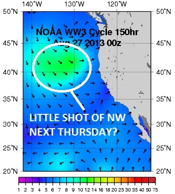
There's little peaks up and down the beach, the water is in the high 60's, and the weather is spectacular- just in time for a 3 day weekend. Both swells hold tomorrow then back off on Sunday.
By Monday we get another little shot of SW swell again- nothing big but probably waist high+ again- better than what we've had recently.
Tides the next few days are pretty mellow, about 3' all day then it hits 5' at sunset. Make sure to keep up to date on the waves/weather at Twitter/North County Surf.

FORECAST:

After a little weekend of surf and nice weather, we get a little boost from a NW groundswell on Tuesday for waist high waves in town and maybe the odd chest high set in south SD. The middle of the week looks tiny then we should get another shot of small NW/SW for next weekend. Nothing spectacular but at least some little waves every few days.

WEATHER:

Amazing weather lately. But what do you expect from late August/early September? The temp when I got up this morning was already 75 degrees due to all the tropical moisture streaming in from the south. It will continue to stream in today for thunderstorms out in the mountains/deserts and maybe even a stray one in the inland valleys. The beaches of course will get those killer looking clouds and amazing sunsets. Tomorrow the monsoon clouds will back off and we get a slight return of the night and morning low clouds/fog over the weekend but nothing to really mess up a day at the beach. The 2nd half of next week shows a return of tropical clouds on the weather charts.

BEST BET:
Today! Peaking SW swell, a little NW, and great weather. Why are you even at work right now?!
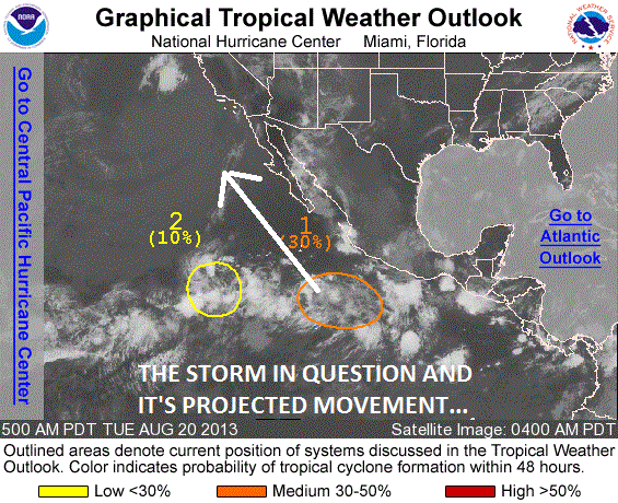
NEWS OF THE WEEK:

Considering it’s been small around here lately and we’re not getting any love from hurricanes in the Eastern Pacific, I thought we should take a look at our East Coast counterparts and see if they’d have any luck lately. Here’s the latest from the NOAA:

Andrea, Barry, Chantal, Dorian, Erin... who’s next? Probably plenty more, according to NOAA’s updated Atlantic hurricane season outlook. With five named storms already in the books this summer, the 2013 hurricane season is shaping up to be above normal, and there is a possibility that it could be very active during the peak of the season from mid-August through October. An additional 9-15 named storms are likely, of which 6-9 are predicted to become hurricanes, with 3-5 reaching major hurricane status.

Among the climate factors behind the heightened activity? Heat. The tropical cyclone heat potential of the tropical Atlantic Ocean has ramped up considerably between May 24 and August 4. This “hurricane heat potential” depends not just on the surface temperature, but on the depth of the warm water.

Yellow and orange colors indicate places where the amount of heat in the water column is enough (at least 50 kilojoules per square centimeter) to significantly impact the intensity of hurricanes, provided that atmospheric conditions are also favorable. Blue colors show where there was no hurricane heat potential; water temperatures were below 26°C (80°F)—the minimum temperature needed to sustain hurricanes.

On May 24, just before the start of the Atlantic hurricane season, most of the ocean energy available for hurricanes was confined to the northern Caribbean Sea , which is typical for that time of the year. Prior to June it was generally not conducive to tropical storms and hurricanes in much of the Atlantic basin. In contrast, the hurricane-fueling warmth had expanded significantly by early August, extending east across the Caribbean Sea and tropical Atlantic Ocean, north into the Gulf of Mexico, and even into the Gulf Stream Current just off the southeast coast of the United States.

The preseason hurricane outlook, issued on May 23, cited developing climate conditions that appeared to be similar to those that have produced many active Atlantic hurricane seasons since 1995. These climate factors included above-average Atlantic sea surface temperatures and a stronger rainy season in West Africa, which produces wind patterns that give storm systems the fuel they need to develop into tropical systems and hurricanes.

As the summer progressed, warm waters expanded far enough eastward into the Atlantic during June and July to help generate two named storms, Chantal and Dorian, in the deep tropical Atlantic. Named storms forming in this region as early as June and July are historically an indicator of an active season. Tropical Storm Chantal dissipated after skirting the southern coasts of the Dominican Republic and Haiti, and Dorian lost steam as it moved northeast off the Carolina coast.

By August, all of these indications of an above-normal hurricane season — early summer storms generated in the deep tropical Atlantic, above-average Atlantic sea surface temperatures, and a strong rainy season in West Africa — remained. Consequently, the updated outlook remained similar to the pre-season forecast, except that forecasters made a very slight downgrade. They now do not predict quite such extreme levels of storm activity throughout the next few months. Why?

Back in May, the El Niño-Southern Oscillation (ENSO) climate pattern remained in a neutral phase in the tropical Pacific, but it was too early to rule out the possibility that the pattern’s cool phase, La Niña, could develop. La Niña tends to increase hurricane activity in the Atlantic and, if it had developed on top of all the other hurricane-friendly climate conditions, the seasonal predictions could have been even higher.  In the early August outlook, however, models indicated that ENSO-neutral conditions are likely to continue through the season, with only a low probability (19 percent) that La Niña will develop.

BEST OF THE BLOG:

If it's not the housing boom lately then it's all the new business construction going on that has me convinced good times are here again. Start spending everybody! The Reagan years are back! Maybe not that drastic but there's been a heck of a lot of existing home sales, new home construction, restaurants popping up, and new businesses being built. Like the old Olympic Resort being torn down and Lowes going in or Pat & Oscar's being raised and doubled in size to make way for Palomar Place. Check out the full story on the North County Surf blog. All of that  and more, plus the mid-week Surf Check and an in depth THE Surf Report at www.northcountysurf.blogspot.com

PIC OF THE WEEK:

Bought a plane ticket and I'm headed to the islands in October. The lack of surf here on the mainland has driven me to do drastic things. Actually, I'd go to Hawaii regardless, but it just makes me feel better when I see my credit card statement next month.

Keep Surfing,

Michael W. Glenn
Tycoon
Broke Up With Miley
Talking to Kickstarter to Put An Atlantis Resort On The Ranch

Thursday, August 29, 2013

North County New Business News: Pat & Oscar We Hardly Knew Ye


About 20 years ago the 1st Oscar's restaurant opened in San Diego and quickly expanded. The food consisted of the world's best breadsticks, chicken, pizza, etc. And heaping portions of it. In 2000 the Sizzler chain got wind of Oscar's and purchased the chain. During the expansion, Sizzler changed the name to Pat & Oscar's for reason's unknown and peaked around 18 locations. After faltering under Sizzler's control, the management team bought out the stores and the 11 remaining franchises changed the name to O's American Kitchen around 2011. So where am I going with this? Well there used to be a Pat and Oscar's in the Costco parking lot in Carlsbad in the corner of Armada Drive and Palomar Airport Road. I used to take the family there all the time- either after a LEGOLAND visit or a Costco trip. The location has been vacant for a couple years even though it was in a prime location- visible from Palomar Airport Road and next to Costco and the Costco gas station. Basically if Pat & Oscar's couldn't make it there, nothing could.
Now 2013 comes along and the building as well as surrounding parking lot is being developed into 'Palomar Place'. The original Pat & Oscars location was about 6,000 square feet and a new building has been built next door effectively adding another 10,000 square feet of retail in the location for a total of 16,000.
There's a sign at the location showing 7 retail businesses available. From what I gather there's going to be a bundt cake store, nail salon, and Supercuts. I'll take Supercuts and the bundt cake store- you can have the nail salon. That leaves 4 more stores going in. There's one location on the map that looks to be about twice the size of the other tenants. I'm assuming that will anchor the center and most likely will be food related. I'm hoping for Mexican.

With the new Lowes going in and the Pizza Port running at full steam, there's plenty of new business going on Palomar Airport Road.

Tuesday, August 27, 2013

Surf Check

The last few weeks have been the easiest to forecast as well as the most maddening- no storms means an easy time to predict the surf but also pretty depressing. Today we have yet again tiny NW and tiny SW in the water.
There's maybe some waist high waves in south SD and north OC. Good news is that the water is slowly creeping back up to 68 and the sun is already out.
Tides the next few days are around 2' at sunrise, up to 5' late afternoon, and down to 2' again at sunset. Heck- even the tides are boring!
The weather should be nice the next few days- finally. Early August had a ton of low clouds and cool temperatures. We're finally back to sunny skies and temps in the mid to high 70's at the beaches. There's maybe another shot of tropical moisture headed our way towards Thursday/Friday but only rain for the mountains/deserts.
As far as the surf goes, we had a weak little storm off Antarctica send us a little SW shot and we should get some waist high waves around here towards Thursday. The tropics are also trying to flare up today and we may get a little knee to waist high S swell too. Sad to say but I'm excited. I swear we must be living in Florida.
After the little S/SW Thursday/Friday, we may get a little waist high NW in SD for the weekend. Still nothing solid but good enough for your groveler board.
The storms in the southern hemisphere are still pretty feeble but the models show a couple small storms trying to get their act together today. If they hold up, we may get waist high SW sets again towards Labor Day.
And as we get closer to fall, the north Pacific is starting to wake up. Charts show yet another small storm trying to get it's act together and we may get another waist high NW swell late next week.

So there you have it- the water is trying to warm up, we finally have nice weather, and we're due for a few small pulses from the NW and SW. A wavepool sounds good right about now...


Friday, August 23, 2013

THE Surf Report


'A' for effort.

SURF:
Still flat out there. Unless you're a grom then it's all time!
Just knee high surf around town and the OC has some sets almost waist high from the SW. The weather is great but that doesn't help the surf much. Tomorrow looks to be the same.
Currently there's a tropical depression off Baja trying to form into Tropical Storm Ivo. If it does, it's going to move NW towards us (good) but then die as it hits the middle of the Baja Peninsula (bad). Winds may only hit 50 mph which won't make the best swell but by late Sunday the OC may see some chest high sets from the S and maybe waist high in SD. Hey- it's better than nothing.
We also had s small storm form last week in the southern hemisphere that should give us a little waste high swell too. Along with Ivo, Sunday may have a couple small waves to ride.And unfortunately our typical afternoon WNW sea breezes this past week have knocked down our water temps to the mid-60's. Even though the weather is warm- the water isn't- make sure to pack that spring suit or short sleeve full for your next session.
Tides the next few days are around 0' at sunrise, 5.5' at lunch, down to 0.5' at dinner, and up slightly to 2' at sunset. Make sure to keep up to date on the waves/weather at Twitter/North County Surf.

FORECAST:

The little tropical S swell holds into Monday morning and then we've got a little SW swell (notice a common theme in THE Surf Report today? It's 'small'. Killing me.) filling in late Monday for waist high waves in north county SD and maybe the odd bigger set in the OC.
After that we've got another small SW trying to form in the southern hemisphere late next week and another 'Ivo' situation taking hold off Baja again next Friday. Nothing spectacular but bares watching.

WEATHER:

Great weather on tap today with a couple tropical clouds overhead and no fog in sight. Tomorrow should be the same with clear skies and beach temps near 75. The only real excitement around here is the tropical clouds Ivo is supposed to stream into our area starting Sunday into Monday. If the models hold true, we may get a shot of showers across all of southern California- not just the mountains and deserts which would be typical this time of year. The clouds clear out towards Tuesday and holds through Thursday with a chance of night and morning low clouds returning. Charts then show another tropical system trying to form late next week which would give us monsoon type clouds again next weekend.

BEST BET:
Sunday with the little tropical S swell SW groundwell and  or maybe late Monday with another little SW swell- If the tropical rain doesn't make a mess of things.

NEWS OF THE WEEK:

Been a pretty uneventful hurricane season so far. If it wasn't for the soon to be Tropical Storm Ivo streaming thunderstorms into our region this weekend, it would be downright boring around here. I thought it would be a good time to take a look at 2 items today: what the hurricanes/tropical storms have done so far this season and what other tropical storms in the past have sent their significant weather to southern California.

As far as our season goes, we haven't had any barn burners yet. There's been 8 named storms and only one has given us a little shot of surf (Cosme)- and even that was hard to detect due to it's small size. Basically the storms have gone due W towards Hawaii or they've died out before they hit our swell window.

So the only real excitement is Ivo sending it's clouds our way late this weekend. As I mentioned in a previous THE Surf Report story a few months ago, we haven't had a full-blown hurricane hit us in recorded history, but we've been close. Here are a few of the more notable tropical cyclones that have affected Southern California:

- The San Diego 'hurricane' of 1858. This is the only tropical cyclone ever known to have affected California as a hurricane. Independent scholar Michael Chenoweth and researcher Christopher Landsea of the National Oceanic and Atmospheric Administration reconstructed the storm in a paper published in 2004 in the Bulletin of the American Meteorological Society, using newspaper reports, daily weather observations by U.S. Army surgeons, ship observations and U.S. Coast Survey notebooks. The storm formed in the eastern Pacific Ocean in late September and intensified into an estimated Category 1 hurricane with highest winds of about 85 miles per hour (74 knots). By Oct. 2, its untypical north-northeasterly course had steered it just off the coast of San Diego, where cooler waters and strong wind shear weakened it slightly. Luckily, just before making landfall, the storm made a turn to the west-northwest, and then dissipated near Santa Catalina Island. Despite the near miss, instrument records in San Diego indicate the area experienced hurricane or near-hurricane force winds of approximately 75 mph (65 knots), heavy rain and considerable property damage. Heavy rainfall was also reported in San Pedro, Los Angeles and Visalia — up to 7 inches (18 centimeters) in places. There were few reports of significant winds in the Los Angeles region, however. The researchers reported that based upon historical records and modeling results, such a storm can be expected in the San Diego area about every 200 years, most likely during an El Nino event.

- The Tropical Cyclones of the El Nino of 1938-39. In Sept. 1939, just weeks after "The Wizard of Oz" premiered at movie theaters, Southern Californians may have thought they were in Kansas as well, as the first of four tropical cyclones affected the region during the El Nino of 1938-39. The first two storms – remnants of hurricanes – tracked northeastward across northern Baja California into southwest Arizona, bringing heavy rainfall to parts of Southern California: up to 7 inches (18 centimeters) for the first storm and up to 4 inches (10 centimeters) for the second. A third storm dissipated in southern Baja California but brought up to 3 inches (8 centimeters) of rain to parts of the Southland. Then, on Sept. 25, an unnamed storm made landfall near San Pedro with winds near 50 mph (43 knots), becoming the only tropical cyclone to ever make landfall in Southern California as a tropical storm in recorded history. In addition to the winds, the storm brought up to 5 inches (13 centimeters) of rain to the Los Angeles basin and as much as 12 inches (30 centimeters) of rain to the surrounding mountains. The storm caused heavy flooding and killed at least 45 people, mostly at sea. Low-lying coastal regions from Malibu to Huntington Beach were flooded, and thousands of people were stranded in their homes. There was heavy street flooding — up to 3 feet (1 meter) in places. Ten homes were washed away by waves in Belmont Shore. There was significant agricultural damage. The pier at Point Mugu was destroyed. There was significant disruption of communications throughout the region. The fact that the storm came on suddenly, leaving many people unprepared, led to the establishment of a Southern California forecast office for the United States Weather Bureau in 1940.

- Kathleen. In mid-September of 1976, during an El Nino year, Hurricane Kathleen made landfall in northern Baja California and moved into California and Arizona, still at tropical storm strength. Sustained winds of 57 mph (91 kilometers per hour) were reported in Yuma, Ariz. The storm brought 6 to 12 inches (15 to 30 centimeters) of rain to Southern California's central and southern mountains. Ocotillo, Calif. suffered catastrophic damage, with 70 to 80 percent of the town destroyed. Twelve deaths were blamed on the storm in the United States. The Associated Press reported hundreds of homes were destroyed or damaged in the United States by Kathleen, which was described as a one-in-160-year event.

- Linda. Sept. 1997, also an El Nino year, brought one colossal near-miss to Southern California with Hurricane Linda, the strongest eastern Pacific hurricane on record. This Category 5 hurricane at one point had maximum sustained winds of 185 mph (161 knots). For a couple of nerve-wracking days, National Hurricane Center forecasters warned the storm could barrel into Southern California, most likely as a tropical storm. Fortunately, the storm turned westward away from land. Still, Linda brought significant rainfall across parts of Southern California and waves up to 18 feet (5.5 meters), and caused several million dollars in property damage.

- Nora. Also in Sept. 1997, in the wake of Hurricane Linda, Hurricane Nora crossed into California and Arizona from Baja California as a tropical storm, bringing heavy rains to parts of southeast California and Arizona. The storm caused hundreds of millions of dollars in damage, especially to agriculture.

BEST OF THE BLOG:

What's the best freesurfer in the world been up to lately? (and I'm not talking about John John since technically he's on tour). I'm talkin' 'bout Dane Reynolds! Yes- he's still alive. Dane's been getting in shape for the upcoming Hurley Pro at Lowers. Not the full psycho Fanning training session but just laying off the beers basically. Check out the full story on the North County Surf blog. All of that  and more, plus the mid-week Surf Check and an in depth THE Surf Report in the blog below!

PIC OF THE WEEK:

Ever heard of the sister city program? It's an organization dedicated to advancing and promoting friendship and good will amongst the world’s nations by developing special relationships between cities. The sister city for Encinitas in case you're wondering is Amakusa City, Japan. Carlsbad has two- Futtsu, Japan and Karlovy Vary, Czech Republic. And Newport Beach has three- Antibes, France, Ensenada, Mexico, and Okazaki, Japan. What does that have to do with surfing? I think surf spots should have 'sister surfs'. Like the sister surf to Pipeline could be Teahupoo. Or Blacks and Hossegor. And today's Pic of the week- Swami's and Bells Beach! Just a thought.

Keep Surfing,

Michael W. Glenn
He-Man
I Love Haters
Unofficially Still A Team Rider For Stubbies

Wednesday, August 21, 2013

Clips of the Day: In Dane We Trust


Dane Reynolds birthday is coming up soon, September 7th to be exact (he's going to be 28 this year- nuts!) and I thought it would be cool to check in with the world's greatest freesurfer (John John still hasn't caught up yet since he's been in and out of rehab the past year and spends too much time on tour).

To start things off, I wanted to point out that Australia has put out some great surf mags over the years. From Surfing Life to Surfing World to Tracks, they've covered some amazing spots to the characters that make up our incredible lifestyle. One of the newest Australian surf mags to hit the shelves is Stab. The just released an in-depth article about the reclusive Dane and his aspirations to get back on tour. You can read it below or see it here.

Stab: Any interest in getting back on tour?
Dane: Ah, I think I get asked that every day. And, I trip out on how often people still think I’m on tour. I trip out on how many people know what the next event is, and ask me if I’m going. It’s weird to me that people are knowledgable enough about the tour to know what the next event is, and they’re not knowledgable enough about it to know that I haven’t been doing it for two years. I might as well be on there. I’m still getting credited the same as being on there. I don’t even know if I could qualify. I’m not very good in s#!++y waves. I’d have a tough time qualifying, probably. But when I watch Tahiti, and then I go surf one foot Emma Wood, I’m definitely pretty jealous of the guys on tour.

What about if they just gave you a wildcard back on? Oh, f*$k, I’d feel so weird taking that with how much work people put in to getting on there every year and all that s#!+. I’d feel like that’d maybe be my last opportunity for doing that sort of stuff, so… maybe. But I’d feel like I was taking the opportunity from someone else. So probably not, actually.

Does seeing John John’s alley oop at Keramas get you psyched up to do tour events? I don’t know if it gets me psyched to do world tour events, but it was sick.

How’d you feel about John John claiming the oop in the comp? It wasn’t ruined by the claim. It was definitely claim-worthy. But I think it would’ve been pretty bada$$ if he didn’t. S#!t, if I landed something like that… I dunno, the best airs that I’ve ever done, it just doesn’t cross my mind to throw my arms up in the air. But I don’t know, if I ever do an air like that… maybe my arms would fly up. I’ve never done any airs like that though, that thing was f$%&*d up.

How do you feel about spots like Brazil or Bells? Is that part of the reason you don’t wanna be on tour, ’cause you don’t wanna do events like that? I don’t know, the waves are fun for Brazil and it’s definitely a necessity to do events in big cities and have a lot of people get to see the surfing live, firsthand. I think that’s pretty important for the tour.

So if you were back on tour, you’d be psyched to do those events? Uuuum… Yeah, sure! (Laughs).

Does the best surfing happen on tour? It seems to have been lately. It all happens live. S#!+, it’s hard to say, ’cause it seems like there’s a Brazilian dude doing a backflip every day or something somewhere random, but it comes up on the internet in low resolution and in a way that doesn’t have much impact. I don’t know how that relates to the tour but y’know, I felt like at Teahupoo that was the best tuberiding I’ve ever seen. Every single guy was getting behind the foamball on every wave. You can’t really do that freesurfing, ’cause you’ll be trying to battle with 40 dudes out there trying to catch a wave. It’s pretty nice when you’re in a heat and you can just position yourself as deep as you want and not have to worry about fighting for it or someone getting in your way. When I was still competing, I felt like a lot of the time I would maybe not do the best thing I’d ever done, but surf nearly my best in heats, purely because I was able to get a lot of waves and not have to worry about people in the way or shit like that. You can get in rhythm when you’re catching lots of waves.

You’ve also said that you just wanna be pushing your surfing and that’s why you enjoy doing the events, huh? Yeah.

Are you afraid of failure? Oh yeah, of course. Definitely, f’sure. With everything, not just surfing.

On a scale of 1-10, measure your confidence of success at Lowers. S#!+, I don’t know. I guess, since I said “I don’t know” maybe that’s definitely not in the high range. That’s automatically at least less than a five. I’m gonna try my best. I’ve been trying to eat right and not drink. I mean, not train, but just not be a lazy fat-a$$. Well, I was never lazy, but I just have a sweet tooth and like junk food n’ s#!+. So I’ve been trying to eat right and exercise and get back to, uh, athletic shape (laughs).

This is quite weird. I saw your Instagram. How’s that one guy writing on your Instagram, going f'in mad. Oh yeah, that’s pretty funny. I think I wrote that so cryptically that people didn’t know, like… I’m not expecting results in three days, and I’m not training or anything, I actually am just trying to get fit though. So I was like, “How do you live like this?”

It’s boring isn’t it? Yeah, I just wanna eat a pizza.

You don’t measure success at an event by winning or losing, do you? I always felt pretty happy with my performance if I just felt like I surfed my best. If you have an 18-point heat and still lose, you still feel pretty good about yourself

On that note, I hope Dane makes it back on tour. Could you imagine a quarterfinals with Kolohe, Dane, Medina, Kelly, Julian, Jordy, John John, and Josh? There'd be more tweaked out and bigger airs than a Kai Neville film.


Ran across this clip today on Quiksilver's site. I think it's from last year's France contest. Lots of frothy wonky barrels.

And of course Dane's own website Marine Layer Productions puts out unbelievable clips from time to time. He's got an old school clip of himself when he was 19- and he was surfing just as insane back then as he is today. Dane won't let you post videos from his site so you have to check out the clip here.


Dane and the website What Youth also put together a short film towards the end of 2012 that you may have missed- but shouldn't have- as Dane does his usual 'blink and you miss it' man turns. Above is the trailer which doesn't show much- so check out the full length clip here. You'll be glad you did.

Tuesday, August 20, 2013

Surf Check


Looks like things are starting to get interesting- if you believe the models. But first, let's have a look at today.
Just tiny NW windswell and background SW swell- again- for knee high waves around town. It's also overcast this morning and the water is a pleasant 70 degrees. Wind is already blowing NW@5. Not much to report on really.
Tides the next few days are all over the place. About 0' at sunrise, up to 5.5' at 10am, down to 0' again late afternoon, and up to 5' at sunset.
Tomorrow looks to be small and then Thursday the OC gets a tiny bump out of the SW. Charts last week showed a storm on the edge of our swell window last week and that swell will give the OC some small waist high waves Thursday/Friday. Unfortunately for SD, not much down here.
The weather through the rest of the work week looks pretty tame- just some night and morning low clouds and fog with temps in the low 70's.
Models show a little storm trying to get it's act together today which could possibly send us some waist high+ SW towards Sunday and maybe chest high for the OC.
I applaud you for getting this far because this is where the real meat and potatoes of the story happens. Models this morning show clouds getting organized off mainland Mexico. If everything comes together, we should have a minimal hurricane by late Thursday/early Friday. That in itself isn't all that exciting since all the hurricanes this season have been running away from us- due W towards Hawaii- so we haven't gotten any surf from them.
But this one is different. Potential Hurricane Ivo is forecasted to move in a NNW direction- towards us- which would give us chest high waves in north county SD late Sunday/early Monday and head high surf in the OC. Definitely better than it has been around here lately. And models show a small knee high+ NW windswell taking shape around the same time so it may break up the S lines.
And if that wasn't enough, little Ivo should break apart late in the weekend and send us it's tropical moisture. I'm not expecting rain at the coast but the cool looking tropical clouds overhead would be a great addition to the fun surf. Now of course Ivo hasn't even formed yet so make sure to check Twitter/North County Surf for all the developments.


Friday, August 16, 2013

THE Surf Report


We got surf!

SURF:
Actually it's flat but I needed to get your attention somehow to keep reading.
Lack of storms has equaled lack of surf in southern California and we're kind of in a drought right now. And it's not getting better anytime soon.
Charts show a little NW windswell trying to fill in on Sunday so maybe south SD will have waist high surf- but that's about it. The weather should be nice today and tomorrow with 70 degree water temps- so we have that going for us.
Tides the next few days are around 4' at sunrise, 2' at lunch, up to 6.5' at dinner, and down slightly to 5' at sunset. Make sure to keep up to date on the waves/weather at Twitter/North County Surf. 

FORECAST:

Charts yesterday showed a good storm forming off South America but unfortunately it's almost SSE of us so the swell really has to bend back around to get to us. The OC will pick up most of the swell- probably waist high+ towards Thursday. Other than that, there's no NW windswell on the models for next week and the tropics are pretty quiet.

WEATHER:

Weak low pressure off northern California finally moved inland yesterday and we have high pressure in Arizona controlling our weather today and tomorrow. Look for mostly sunny skies and temps in the low 70's. And as luck would have it, weak low pressure off northern California returns on Sunday and into next week. Look for a return of low clouds, fog, and cooler temps with daytime temperatures struggling to hit 70 and lows at night in the low 60's. Not really feeling like late summer around here.

BEST BET:
If you live in SD county- maybe Sunday with the tiny NW filling in. Or if you live in the OC- maybe Thursday with the tiny SW filling in.

NEWS OF THE WEEK:

We all know that man's best friend is a dog. But if you're a surfer, it's a dolphin. Considering they've been known to attack sharks, I love nothing more than seeing pods of dolphins in the line up. We also know that next to humans, dolphins are a close 2nd in the intelligence department (and rumor has it smarter than some humans like Mayor Filner). Dolphins even have names for each other and remember one another decades apart says a new study reported in Time magazine. Read on...

In his Hitchhiker’s Guide to the Galaxy books, the late, great British satirist Douglas Adams wrote that dolphins are the second most intelligent creatures on earth — before humans and after mice, which spend their time running complex lab experiments on scientists. The mice might not quite live up to their No. 1 billing, but the more we learn about the cognitive abilities of dolphins, the more they indeed seem to have the No. 2 spot locked up. Not only do dolphins have impressive memories for tasks, the ability to use tools and elaborate social structures, but they also have their own names, distinctive identifying whistles that they develop themselves. Now a study in Proceedings of the Royal Society B reports that dolphins can recognize the whistles of others they shared a tank with as long as 20 years ago, the most enduring social memories ever observed outside of humans.

The study, undertaken by Jason Bruck, then a graduate student at the University of Chicago, used 43 dolphins ranging from 4 months to 47 years old that are cycled among various institutions as part of a captive breeding program. Some of them had lived together for only three months; others had shared a tank for more than 18 years before being separated. Bruck first obtained recordings of each dolphin’s name whistle. Then he set up an underwater speaker in the dolphins’ tanks that played whistles from strangers and from former tankmates. The difference in the dolphins’ reactions was unmistakable.

“When they hear a dolphin they know, they often quickly approach the speaker playing the recording,” Bruck said in a prepared statement. “At times they will hover around, whistle at it, try to get it to whistle back.” They paid far less attention to a stranger’s whistle-name.

Moreover, it didn’t matter how long the animals had been separated — a dolphin could recognize the call of a companion it had last seen decades ago just as easily as one it last saw six months ago. Nor did it matter how short or long the animals had been housed together; they responded with the same recognition to a long-term friend or a more fleeting acquaintance. In the most impressive case, a dolphin named Bailey recognized the whistle of Allie, her tankmate 20 years and six months ago. “This shows us an animal operating cognitively at a level that’s very consistent with human social memory,” Bruck said.

Wild dolphins have a life expectancy that ranges from 20 to 50 years (though such superannuated adults are rare), and they live in ever shifting pods, with individuals constantly splitting off and reuniting with the group. Bruck suggests that animals with such a social structure may benefit from a long memory for one another, perhaps supporting a connection between complex social behavior and the evolution of memory. But it may also be that a prodigious memory for names is just part of the larger, fascinating package of dolphin intelligence, included for no particular evolutionary reason — another element of the hidden depths of a mammalian cousin that we continue to explore.

BEST OF THE BLOG:

Make sure to keep up to date on the waves mid-week with the Tuesday Surf Check. And with the Billabong Tahiti contest going on this week, take a step back in time and relive the Code Red swell at The North County Surf blog Clips of the Day. All of that  and more, plus an in depth THE Surf Report in the blog below.

PIC OF THE WEEK:

When someone tells you it was round out there today, this is what they meant. Oh- and if they said they road the foamball, this is what they meant too. 

Keep Surfing,

Michael W. Glenn
Illusionist
Flipper In A Previous Life
Wore a Fullsuit to My Prom