Friday, June 29, 2012

THE Surf Report 6/29/12- Late Edition


Still waiting.

SURF:
Had some little combo SW/NW earlier this week and great conditions for chest high sets around town. Air was mid-70's at the beaches and water temps creeped back up to the high 60's in SD and mid-60's in the OC.

Today both swells are gone and we're left with waist high sets from the SW in far north SD county and the OC. For the weekend we're pretty much left with background waist high SW swell and maybe a touch of waist high NW windswell Sunday afternoon. All in all a pretty mellow weekend with nice weather and not much surf.
Tides this weekend are 3' at sunrise, 1' at lunch, 6' at dinner, and 3' at sunset. Make sure to keep up to date on the waves and weather at Twitter/North County Surf. 

FORECAST:


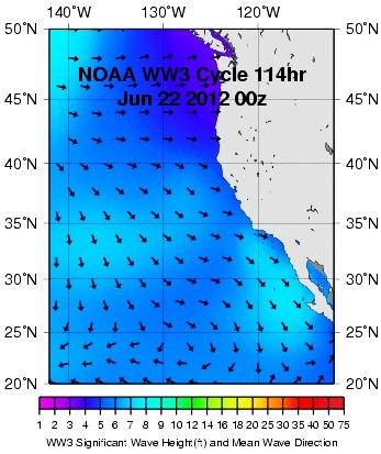
After the small weekend of surf, charts show some NW windswell forming off central CA on Monday for some waist high waves in SD for Tuesday.


We've also had some storms in the southern hemisphere that will send us some waves towards Thursday into the Saturday. Nothing major but some head high sets finally. Long story short- pretty quiet the next 4-5 days and then some fun SW swell after the holiday.


WEATHER:

Just more of the same in the coming week. Some night and morning low clouds and hazy afternoon sunshine with temps in the low 70's. Maybe a little more low clouds/fog for Sunday/Monday but nothing major- just a harder time for the beaches to clear up. The 2nd half of next week shows some weak thunderstorms popping up in the deserts but that's about it for excitement around here.

BEST BET:
Looks like Thursday of next week when that new fun SW groundswell shows up. Until then, pretty quiet.

NEWS OF THE WEEK:
Ok- last time I'll talk about rainfall until we get our next real storm- which will probably be late October. But tomorrow is the last day of the rainfall season (It's not a calendar year but rather July 1st to June 30th) so I thought we'd take a look to see how La Nina affected us this past season:
LAX: 7.61". 59% of normal
John Wayne Airport: 6.32". 47%
Oceanside Airport: 8.67" 64%
Lindbergh Field: 8.03". 78%
A couple things to note:
1. La Nina was on track and we received less rain than normal. Indications are though we may have s weak El Nino building later this year so we should have a better rainy season for 2012/2013.
2. San Diego got more rain than LA/OC. That was due to the storm track taking aim a little more south than usual to begin the season.
In a nutshell, make sure to keep those sprinklers to a minimum this summer!

BEST OF THE BLOG:

The Surfing Madonna is back! And she's ripping at Surfy Surfy. Also make sure to check out Summer Fun on the 101 tonight and Saturday in Leucadia. Live music, a beer garden, and good times. Nothing like a cheap date. And of course a mid-week Surf Check and an in depth THE Surf Report. All of that and more in the blog below!   

PIC OF THE WEEK:

Ever heard of Victoria Bitter? "Australia's favourite full strength beer"? As this picture can atest- there's nothing bitter about this place nor too strong. Looks pretty laid back and fun to me.

Keep Surfing,
Michael W. Glenn
Sire
Mad Hops
Had a VB With The Keg On Legs

Tuesday, June 26, 2012

Surf Check 6/26/12

Nothing earth shattering today but looking darn fone nonetheless. We've got a small combo NW windswell joining a SW groundswell for chest high sets. Sun came out early today, wind is 5mph from the W and picking up slightly and water temps are high 60's. Beach temps should hit low 70's today too.

Tides are 2' at sunrise, stay around 1' mid-morning, head up to 5' late afternoon, and go dow to 2' at sunset. Looks fun out there. Good for a lunchtime surf or if you're lucky enough to be out school (like my groms) then hang at the beach all day and get crispy.
If you like the summer weather today, then you're going to love the rest of the week. High pressure is setting up shop and we'll have sunny warm skies through at least Saturday. Look for minimal low cloud presence in the nights/mornings- finally. Pretty cool to wake up at 5:30am, see the sun out, and get a quick surf in before work. Just need some more surf!
On the forecast front, just some minor SW swell the next few days and the small NW windswell will die off. We do though have winds increasing slightly towards the weekend off Point Conception and our outer waters for more waist high+ NW windswell for the weekend and slightly bigger towards Monday.

And the southern hemisphere has been fairly quiet and unorganized (what's new this spring/summer)but it will at least send us some small background SW swells towards Friday for chest high sets similar to today. Luckily there's a storm on the charts today which may give us shoulder high+ surf (and slightly bigger sets for the OC) towards the 4th of July holiday. God bless America!

The Surfing Madonna Spotted At Leucadiapalooza

Looking for a cheap date this weekend? Look no further as Leucadias 'Summer Fun On The 101' is back and bigger than ever. If you thought the Switchfoot Bro-Am at Moonlight was packed, then check out the line up this Friday and Saturday:

From 5:30pm to 9pm (but probably longer) on Friday, Lou's Records parking lot will host Thieves of the American Dream, Inspired & The Sleep, Red Fox Tails, Glen & The Boys (no relation), and Amerikan Bear & The Spanish Moss.

That alone is a full night in itself. But wait! There's more! On Saturday morning at 11:30am there will be a beach clean up from Moonlight to Beacons. Then head on over to Surfy Surfy/Coffee Coffe (a.k.a Cafe Ipe) for music from Julie Cowley and Megan Combs from 10am to 11am. And if you can muster it, Leucadia Roadside Park at 11am to 9am will have a full day of music from Superwave, Mattson 2 with Ray Barbee (solid), The Donkeys, and more. And did I mention a raffle and beer garden?! Just like Lollapalooza but in Leucadia. And without the freaks. All the music is free but donate $10 to the Paul Ecke School Garden and the Leucadia Main Street Association to keep great events like this and our schools running!
And lastly, while you're at Surfy Surfy/Cafe Ipe on Saturday, make sure to check out the new home of the Surfing Madonna. Last year you probably heard/saw the amazing mural by local Mark Patterson that he installed under the downtown Encinitas train trestle in the middle of the night. The city of course called it 'graffiti' and asked for it's removal. Well JP at Surfy Surfy has donated one of the walls outside his shop to house the famouse piece of art. A perfect spot for it. Make sure to grab a cup of joe, a bar of wax, and gaze at the mosaic this weekend!


Friday, June 22, 2012

THE Surf Report 6/22/12


Similar to last week's report. And the one before that. And the one before that...

SURF:
Had some fun NW windswell this week for shoulder high sets in south SD. There was some little SW groundswell underneath too but it wasn't much of a factor. And the weather tried to cooperate with partial afternoon sunshine.
Today the NW has backed off slightly with waist high waves but there is new SW groundswell filling in. Spots around town have shoulder high sets and there are some head high sets at the best OC spots and far north SD county. Sun has come out early too. Look for the SW to hang around tomorrow and the NW windswell to increase a touch. The clouds unfortunately will hang around at the beaches though a little longer this weekend as we have yet ANOTHER weak cold front moving through nor-Cal and it's kicking up our low clouds. Surfwise on Sunday, the SW and NW windswells will be backing off slightly but there should be some chest high sets still. All in all nothing spectacular this weekend but it will be fun. And I'm hoping the clouds break up for at least some sun from noon to 4 at the beaches both days.
Water temps are mid-60's and tides the next few
days are around -1' at 7am, 4' mid-day, and 2' in the evening. Make sure to keep up to date on the waves and weather at Twitter/North County Surf.

FORECAST:
After a weekend of fun surf, there's no real SW swells headed our way or major NW windswell activity OR hurricanes happening.
Models show a slight bump from the NW windswell on Tuesday but that's only going to be waist high+ in SD.
The southern hemisphere is trying to become active (again) but charts don't show that happening until the 29th of June- which would give us surf late in the 4th of July weekend. Until then, get it this weekend!

WEATHER:

After the little cold front moves through nor-Cal this weekend and kicks up our clouds with temps in the mid to high 60's here, we should have weak high pressure build in behind it by mid-week. No real warm up but the clouds should burn off by mid-morning and leave us with sunny skies and temps at the beaches in the low 70's. One interesting note; there's a low pressure system trying to form in the Gulf of Mexico this weekend. When high pressure forms over the southwest next week (for our nice temps advertised above) that low may break apart and the humidity/clouds may get sucked into our region. That's a long shot but still an interesting scenario- tropical weather in so-Cal.

BEST BET:
Even though the low clouds increase tomorrow for only partial afternoon sunshine at the beaches, we do have a holding SW groundswell and building NW windswell for shoulder high combo peaks. Get your honey-do's done and get on it!

NEWS OF THE WEEK:
NOAA's Climate Prediction Center came out with their 3 month forecast recently. Now I know 3 months is a long way off to predict the weather- considering it's almost impossible to get the weather right a week out. But some factors come into play to make the forecast that far out somewhat believable- namely the slight El Nino forecasted for the 4th quarter this year. If our water temps warm up slightly by the end of summer, we should have a few things happen. 1. Land temps won't be cooled off by the cold ocean so we'll have above normal temperatures in the southwest. Most likely an 'Indian Summer' with warm temps and a little more humidity. Sure beats the foggy days we had the past few Augusts. 2. The warmer water temps will mean we can keep those 3/2 fullsuits at bay hopefully through October. I remember the strong El Nino we had back in '97/'98 (I sound like an old man- which I'm not of course)- I trunked it during a dawn patrol session on November 4th. I'm not claiming the same, but we should have mild temps through October and maybe use a springsuit at worst. 3. Warmer water will fuel more monsoon type weather in the desert southwest (with some of those clouds and humidity drifting our way).  And 4. More fuel to grow those Aleutian storms and subsequently bigger surf/more rain this winter. In a nutshell, look for warmer air temps late summer, more humidity, and a chance of a good soaking this winter. But don't quote me on that!

BEST OF THE BLOG:

Still waiting for the Kelly Slater and Greg Webber wave pools to come to fruition. Until then, we're left with our dreams of Dubai, Orlando, and the now defunct Miyazaki barrel (R.I.P.). The blog this week has some clips of these chlorine compounds in action that you'll want to see. And as usual the North County Surf blog's got the mid-week Surf Check and a more detailed THE Surf Report. All of that and more at in the blog below!

PIC OF THE WEEK:
Thought you deserved a treat this week with 3 pics. Now granted, don't expect dreamy shots of Rincon, Pipe, or Ulu. But rather some of the obscure waves of the world; in this case, an island off Europe, the Gulf Coast during hurricane season, and man playing God. All beautiful in their own rights (or lefts for that matter).

Keep Surfing,

Michael W. Glenn
Jack of All Tirades
Outbid For Lanai
Rather Go Over The Falls In A Barrel At Nias Than In A Barrel Going Over The Falls At Niagra

Thursday, June 21, 2012

Clip of the Day: Wavepools Are Wonderful


Last year the North County Surf blog talked about the wavepool wars heating up between iconic Australian shaper Greg Webber and 12 time (ooops), I mean 11 time soon to be 12 time world champ Kelly Slater's competing wavepool technology companies. They are promising 10' barrelling surf that runs in a circular pool to simulate looooong pointbreak type rides. Until it happens, I ain't buyin' it. So I thought it would be good to look at the current technology out there and show everyone there's some fun darn waves to ride if you have the money or means.

First up is the Dubai Double Up you may have seen this week on the world wide web. The crew from Globe hooked up with an arab sheik and his skate park in the middle of the desert. Seriously. It's a cool set up (cool being a relative term since it's 115 degrees in Dubai this time of year). The cool part I speak of is the wedge off the wall you sling shot into, get a quick hit in, then wait for the wave to come together at the end in the launch section. Long story short- it's only a couple turns, but the end section is just begging to be hit. And if this thing was in Palm Springs- I'd be there every weekend.


And there's Typhoon Lagoon in Orlando- probably the most famous and photographed wave pool in the world. Everyone from Slater to Kolohe has surfed this thing. Not the best wave, but it's close to the Surf Industry East, it's in the middle of Disney World, and since Florida goes flat months at a time, it's a relief to the surfers who have the key to the Magic Kingdom.


Unfortunately, one of the best wave pools ever was the Ocean Dome in Miyazaki, Japan and it is now defunct. It had a shoulder high barrel and plenty of punch to launch. And if the weather was bad, just close the retractable roof and crank up the AC. Not a bad set up. Well actually it was bad; it didn't stay in business. Anyway, Owen Wright and Julian Wilson were one of the last to ride it and the clip above showed the potential of wavepools.

Hopefully someone figures out how to make wavepools with real waves AND cost effective so we can do something on flat days besides play golf!

Tuesday, June 19, 2012

Surf Check 6/19/12


Got a couple fun waves out there today- still nothing exciting- but there's little corners to be ridden. The main source of surf is our continuation of NW windswell with some inconsistent SW groundswell. Best spots have chest high sets. Overcast 'June Gloom' conditions are on tap again today and the wind is W at 3 this morning and will top out around 10mph this afternoon.

Tides are pretty mellow today with a 0' tide at sunrise, going to 4' before lunch, down to 2' mid afternoon and up to 5' at sunset. Water temps have dropped slightly due to the W wind the past few days and lack of sun. We're mainly dealing with water temps from 63-65.

As far as our weather goes the next few days, we've got overcast conditions at the beaches today as a weak cold front moves through northern California and kicks up the low clouds down here. High pressure sets up behind it Thursday/Friday and we should have clearing conditions at the beaches by mid-morning and temps in the low 70's. Then yet ANOTHER weak front moves through northern California and kicks up yet MORE low clouds from Friday through the weekend (stoke). High pressure should return early next week. Just don't expect any real summer weather until then.

On the surf forecast front, it's been really boring the past 2 months. Just consistent waist to chest high NW windswell and no real surf from the southern hemisphere. Due to the lack of southern hemisphere storms, it's been really hard to predict the small SW swells we've been getting. Something small will flare up down there and shoot us a little waist high swell but it tends to get lost between here and there as well as get jumbled from all our NW windswell. The upcoming days are no different- we've had little blips on the radar down there but it looks to be only waist high+ SW towards Friday maybe? Nothing to skip work over but it should be rideable towards the OC.

And we should have a continuation of NW windswell the next week due to those weak cold fronts coming down the coast. Look for more waist high+ surf the next few days with maybe chest high sets this weekend towards SD.
We've got some clouds trying to organize off Mainland Mexico today and it should turn into a hurricane by tomorrow but unfortunately it's moving E towards land and at this time it may not hit our swell window. Hopefully the charts are wrong!
Long story short, nothing exciting on the weather or wave front for at least the next week.

Friday, June 15, 2012

Clip of the Day- Going Kerrazy In Karlsbad


Cheesy title but solid surfing from North County's newest resident Josh Kerr. Originally from Tweed Heads in Australia, Josh moved recently to Carlsbad to be closer to his main sponsor Rusty. At only 28 years young, Josh has done it all- been on tour, off tour, back on tour, and now sits at #7 on the world rankings. Not bad considering a lot of people wrote him off as an 'air' guy- even though he's one of the hardest chargers on tour. Long story short, check out the clip of Josh getting some waves around town and the world.

THE Surf Report 6/15/12

Rinse and repeat.

SURF:
Couple little waves this week from the NW/SW. Far north county SD and the OC had some head high combo sets. The weather was a little suspect as the beaches some days didn't completely clear out.

Today we have more of the same as we have continuing NW windswell and some new small SW groundswell fliling in later. Sets are chest high in SD and inconsistent in the OC. Saturday looks to be the same- with maybe slightly better clearing at the beaches and Sunday looks pretty small- about waist high+ from the SW- sorry all you dads. All in all it's rideable for a groveller but when are we going to get some real waves again and break out the 6'6" rounded pin?
Water temps are mid-60's and tides the next few days are around 1' at sunrise, 3' mid-morning, 2' at lunch and 6' at sunset. Make sure to keep up to date on the waves and weather at Twitter/North County Surf!

FORECAST:

After the little weekend swells it's looking pretty small out there- just no real storms to spark up any surf. Models show a slight bump from the NW windswell on Wednesday but that's only going to be waist high+ in SD.
The southern hemisphere is trying to become active but it's not looking impressivse- MAYBE some chest high waves next weekend?
And the tropics are kicking into gear but Tropical Storm Carlotta is well hidden from our view under Mainland Mex so we shouldn't see any surf from it.

WEATHER:
If the surf doesn't sound too exciting- then you won't be impressed by the weather forecast either! Overcast conditions will prevail at the beaches today with limited- if any- clearing. This weekend we get a little more clearing and nice conditions. Early next week yet another weak cold front moves through the northwest and kicks up our low clouds again. Models though show some tropical 'monsoon' moisture trying to make inroads to our local deserts for maybe our first shot of summer thunderstorms out there and more humidity and sun here. Bears watching.

BEST BET:
A little more NW today for SD but more SW tomorrow for the OC. Since the weather may be slightly better tomorrow, I have to give the edge to Saturday.

NEWS OF THE WEEK:
After the devastating earthquake in Japan back in March 2011, coastal cities in California have been racing to get themselves 'Tsunami Ready'. Ok, not really racing as an article this week in the San Diego Union Tribune points out. Only 3 coastal cities in San Diego so far (Imperial Beach, Coranado, and Imperial Beach) are prepared to face a tsunami and it's after effects. (And for those of you in Orange County- kudos- all of your towns are up to par). So what gives with the SD beach towns? Here's the lowdow from the UT: Newly released federal documents show 158 communities in California are at risk from tsunamis — by far the most in the country — and fewer than one in seven at-risk areas nationwide has been verified as adequately prepared by NOAA. In San Diego County, only Coronado, Imperial Beach and San Diego city make the cut as “TsunamiReady,” according to the latest assessment published online by the National Oceanic and Atmospheric Administration. That leaves lots of local beachfront that hasn’t been certified as having what the agency considers adequate measures in place such as emergency operations support, backup warning systems and a tsunami-response plan. Participation in the TsunamiReady program is voluntary — and it will wither if NOAA ends its financial support as planned, according to Public Employees for Environmental Responsibility, or PEER. The group on Monday released documents obtained through the Freedom of Information Act that showed 767 communities nationwide deemed at risk of tsunamis with about eight new ones being recognized as TsunamiReady each year. Federal documents project that just three communities a year will join the program if NOAA follows through with a proposal to eliminate funding of about $4 million a year. “We have only made a dent in preparing our at-risk communities for minimizing tsunami impacts. Instead of doing more, NOAA is retreating,” said Jeff Ruch, executive director of PEER. “This makes as much sense as eliminating school fire drills to reduce overhead.” Tsunamis are rare in San Diego County. The county’s emergency management office said the most significant remote tsunami to hit Southern California was in 1960. That’s when an 8.6-magnitude earthquake off the coast of Chile generated a tsunami resulting in 4-foot waves at Santa Monica and Port Hueneme, and caused major damage to the Los Angeles and Long Beach harbors. Since 1800, only four locally generated tsunamis have been observed in Southern California, according to the county. The most significant was in 1812 in Santa Barbara and Ventura County. Waves were reported at 6 to 10 feet high, and several small buildings were damaged and many ships were destroyed.

BEST OF THE BLOG:

Roundabouts in Encinitas streets have been popping up the past few years- with more to come- but why? Is there any financial benefit besides wanting to looking like Europe? The North County Surf Blog has the low down. And Carlsbad's newest residence- WCT surfer Josh Kerr- goes big around town in the Clip of the Day. And of course the North County Surf blog's got the mid-week Surf Check and a more detailed THE Surf Report. All of that and more at www.northcountysurf.blogspot.com!

PIC OF THE WEEK:

One of the world's most crowded waves when it's on, but well worth the hassle. Even with that notoriously shallow reef on the inside. Like Turtle says "When the wave breaks here- don't be there". Check out more amazing shots from arguably the world's best surf photographer, Aaron Chang.

Keep Surfing,

Michael W. Glenn
Ultramasculine
Truckmaster
'86 Triple Crown Champ (of Wavepools- Tempe, Irvine, Allentown)

Wednesday, June 13, 2012

North County Business News- Roundabouts Are Good In A Roundabout Way


The Union Tribune had an interesting article this week. They reported on a study that the Brookings Instution had done last month saying homes in walkable neighborhoods hold their property values better than in auto-oriented zones. What does this have to do with north county San Diego?

Well, plans for the Leucadia Streetscape Project call for reconfiguring highway 101 in Leucadia to include roundabouts as well as make it more pedestrian friendly. You may have noticed the new sidewalks about a year ago and the new plants/trees that have been planted the past few months- the streetscape is upon us. But just what exactly are the economic benefits to spending all this tax money? Here's the lowdown on the Brookings report:

The study by Christopher B. Leinberger of George Washington University and Mariela Alfonzo of the Polytechnic Institute of New York University used Washington, D.C., as a case study.
Its conclusions included:
• Property values are higher by $81.54 per square foot for homes in walkable neighborhoods, after factoring out differences in income levels.
• Rents are $301.76 higher per month, also after discounting income differences.
• Office rents are $8.88 per square foot higher per year.
• Retail sales are $6.92 per year higher.
The Walk San Diego group conducted a similar study in 2010 and found similar results.
“As prices declined (during the recession), we saw a less steep decline in walkable neighborhoods,” said Jim Stone, the group’s executive director.

One example he cited was Bird Rock, where the installation of roundabouts to slow traffic increased values and business. Stone conceded that making existing neighborhoods more walkable can require an increase in building density, but a series of workshops and educational efforts is counteracting concerns that more density will worsen traffic and overall quality of life. “We’re starting to get on the path, but we have a ways to go,” he said, when asked if policies are in place to improve walkability. One current effort, he said, is to convince traffic engineers, during the current pothole-filling campaign, to re-stripe streets to narrow lanes, slow traffic, add bike lanes and improve walkability. At 50th Street and University Avenue in City Heights, he said, re-striping worked to reduce dangerous walking conditions. “When they do it, you naturally slow down,” he said. Walk San Diego is planning four community workshops, this month and next, focused on the City Heights area between El Cajon Boulevard and University Avenue. In addition, the group has reached out to get planners and city and county traffic engineers on board and plans a “complete streets” workshop June 22 at the Handlery Hotel in Mission Valley.

Tuesday, June 12, 2012

Surf Check 6/12/12

Had some fun NW/SW combo the last few days with head high sets in far north SD county and the OC. The weather hasn't been the greatest- typical of June with the low clouds having a hard time burning off at the beaches- but the water has been a pleasant 67 degrees.
Today we have lingering SW with a tiny NW underneath for inconsistent chest high sets- and a couple better waves towards the OC. The low clouds should burn off hopefully by mid-day and we may hit a high of 70 in the air temp department.
Tides are pretty mellow for the most part- just 2' in the mornings, about 1' mid-day, and up to 5' at dinner. Wind will be mainly under 10mph from the WSW today.
As far as our weather goes, look for more June Gloom conditions with only partial afternoon clearing at best in the afternoons. Air temps will remain in the high 60's through this weekend and more SW winds are expected. It's technically not summer yet so I shouldn't complain but May sure had better weather and I was at least giving June a fighting chance of being nice. Hopefully we'll get some better weather next week- which is just about the start of summer anyway on the 21st.
On the surf forecast side, our next real source of swell is a weak low pressure system moving down the coast tomorrow and it will kick up our NW winds in the outer waters (again). It's been pretty redundant the past few weeks- no real SW to speak of and our main source of surf has been NW windswell. Better than nothing. Look for chest high surf out of the NW starting Wednesday afternoon and lasting at least through Saturday.
As far as the southern hemisphere goes, we've had lots of little pulses but no real organized storms down. It's resulted in less than stellar SW swells up here. We should have background waist high+ SW through the remainder of the week but it may not be noticeable due to new NW windswell showing up the 2nd half of the week. We may get another pulse from the SW around the 18th. And in the chart shown above, there looks to be a small but potent storm forming on Sunday which may give us head high sets around the 24th. Hopefully it stays together.
And tropics flared up in May but have been quiet since. Models show a little group of clouds off central America trying to get organized. If anything does develop, I wouldn't expect surf until a week out. Make sure to keep up to date on the waves and weather at Twitter/North County Surf!