Thursday, December 31, 2015

THE Surf Report- Early Edition


That was one helluva year.

SURF:
I'm literally at a loss for words as we close out 2015. From starting the year in a drought, to a ton of rain in the spring, to an overactive hurricane season, to record rains this summer, to the hottest year on record- oh- and we're in the middle of one of the biggest El Ninos ever- I'm just waiting for the locust, floods, and the plague. Wouldn't surprise me.
Had another fun week of surf and fairly manageable storms and today we had perfect weather and waist high+ NW swell. Tomorrow looks to be the same and that rolls into Saturday.
By Sunday we start to see signs of a new NW swell but it will only pick up a notch to the chest high+ range. Beware the S winds though late in the day Sunday (more on that in the weather section below). Water temps have dropped A LOT- 60 if you're lucky- due to all the windy storms we've had lately.
And tides the next few days are really mellow- 3' at sunrise, down to 2.5' mid-morning, and up to 3.5' late afternoon.

FORECAST:
So if the models are right, we finally get our Winter El Nino surf next week. As Sunday starts to fill in from the NW, Monday really kicks in with overhead sets. Unfortunately the beginning of Winter El Nino weather kicks in too with showers and wind. Nothing major but that holds into Tuesday.
Then things really get turned up to 11 with sets to 11' and larger surf in SD on Wednesday. That holds into Friday (along with real wind and rain).
Models then show another overhead NW arriving next weekend along with more wind and rain. Finding pockets of semi-clean surf will be hard to come by- along with clean water.

WEATHER:

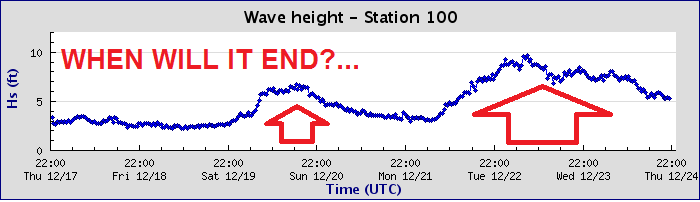
So maybe- just maybe- our Winter El Nino is arrving next week. But first up is nice weather this weekend with temps in the mid-60's during the day and low 40's at night. The jet stream dips south finally and takes aim at northern Baja/southern California. The first storm moves through northern Baja on Monday and we just get some showers here in SD. The next storm should be a direct hit for us on Wednesday. After that, models show another storm for next Friday. All in all some windy and wet weather next week. Finally. Make sure to keep up to date on the waves/weather at Twitter/North County Surf. 
 
BEST BET:
Monday morning with new NW in full swing and the last of our semi-clean days and water quality.

NEWS OF THE WEEK:

As we close out the year waiting for the Winter El Nino to arrive, how did 2015 shape up weather-wise? Glad you asked. We had:

-January 24/25: Santa Ana winds reached 54mph in San Diego and 35 in Solana Beach to mow down trees and raise temps to 90 degrees at the beaches.
-February 12: More Santa Ana winds with gusts over 80 in the local mountains

-March 2: Hail storm left 'snow' on the beaches of Huntington and waterspouts in SD
-March 14: Record heat wave. Oceanside hit 92 degrees (in winter mind you)
-May 14: Record rainfall in San Diego. 1.3" in 1 hour and 1.57" in a 24 hour period
-June 6-13: Hurricane Andres and Blanca bring thunderstorms to the San Bernardino mountains and hot offshore flow to our valleys/coast. Then dry lightening strikes to central CA to start 35 wild fires and rain at the beaches in SD. The local deserts received up to 1.5" of rain.
-June 30: Significant lighting across coast/valleys. 680 cloud to ground and 3225 total flashes. Beaches closed in Orange and SD. Legoland closed.
-July 17-19: Hurricane Dolores makes a mess of southern California. Wind gusts of 60 mph in the local deserts and lightening starts a wildfire in Cajon Pass with 20 vehicles destroyed/burned. SD receives a ton of rain again- this time 1.69" (as a comparison, SD only received 1.65" from January to April). 4" of rain in local mountains.
-September 8-14: Heat wave. Temps hit 90's at the coast and over 100 in the inland valleys. Tropical Storm Linda then turns up the humidity (thanks) and drops 1.5" of rain in Oceanside and 3" in the local mountains.
-October 3 and 12: Low pressure from British Columbia dropped down the coast on 10/3 and gave us showers and moved east towards Texas. No big deal. It then decided to COME BACK and give us rain again 9 days later on 10/12! (The Zombie Apocalypse).
-October 10: highest low temps on record. Meaning: Camp Pendleton was 82 degrees. AT NIGHT. SD was 76. October in general was 7.7 degrees above normal for the month.


-Bonus 1: 2015 was the warmest on record for SD
-Bonus 2: Scripps Pier water temps hit 80 degrees briefly on September 9. Scripp's water temps also hit at least 70 degrees or higher from June 24 to November 2. That's over 4 straight months. Crazy.
-Bonus 3: Water expands when it's warm (in this case, thanks to El Nino) and a storm surge helped propel the tide to 7.8' on November 25th in La Jolla- a record high.
-Bonus 4: El Nino recorded the highest above average water temperature anomaly- 5.5 degrees above the norm
-Bonus 5: On October 23, Hurricane Patricia was recorded as the strongest storm in HISTORY in the East Pacific AND Atlantic with sustained winds of 200mph (a category 5). It also went from a tropical storm (73mph) to Category 5 (over 157mph) in just 24 hours. That is one ANGRY storm.

PIC OF THE WEEK:

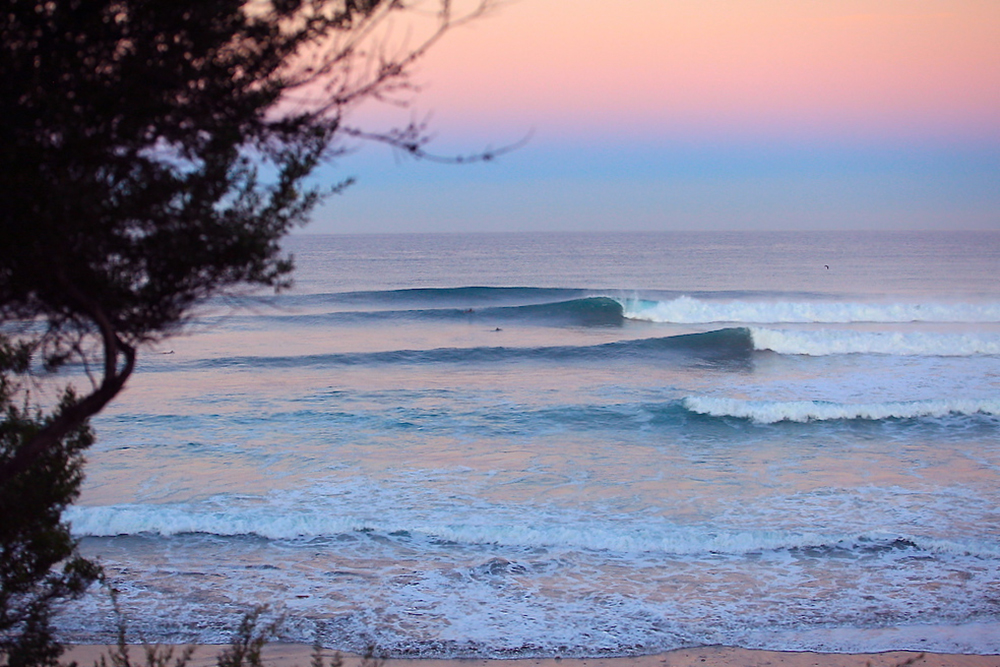
As we close out the year, I thought I'd stick with North County San Diego for the Pic of the Week. As Dorothy from the Wizard of Oz said 'There's no place like home, there's no place like home'. Dorothy also dealt with tornadoes and witches so I'm sure she didn't have surfing in mind when she said that but I agree nonetheless.

Keep Surfing,

Michael W. Glenn
Titan of Industry
Getting a Bowl Game Named After Me
My New Year Resolution Is To Surf 8 Days A Week

Thursday, December 24, 2015

THE Surf Report- Early Edition


Santa is bringing me 'Wind & Waves' this Christmas! (New from Hasbro!)

SURF:

Either you've been loving or hating the surf lately; plenty of waves but lots of wind. And when it finally cleans up, the swell drops. Today we have plenty of surf again with head high sets from the NW in north county and overhead sets in SD. The OC is considerably smaller from island blockage. As far as the weekend goes, if you've been naughty or nice, it won't matter- we're getting a windy storm tonight (naughty) and waves along with it (nice).

Look for blown out conditions tomorrow with overhead waves in town from the NW again and 10' sets in SD. The OC will see some chest high+ waves. Saturday the winds turn offshore, the sun comes out, and the waves leave town. SD still should have some shoulder high waves though. And Sunday is clean again but small.


Water temps are still slightly above normal at 63 (especially with all this wind and upwelling) and tides are fit for a king this weekend (more on that below)- about 5' at sunrise, up to 7.5' at 9 AM, then dropping like a rock to -1.5' late afternoon (that's a crazy 9' swing).

FORECAST:

Monday still looks small with another windy weather system forecasted then the surf picks up out of the NW again on Tuesday. More head high waves for us and overhead sets in SD.


There was also some small activity off Antarctica a few days ago that may give the OC waist high waves from the SW on Tuesday too.

After that, things go quiet for a few days then models show a storm taking shape off Hawaii which may give us solid NW towards January 4th. What's interesting about this storm is that it's at a lower latitude than the others this season- a true El Nino storm. I'll believe it when I see it though!

WEATHER:


Still no signs of El Nino. Last week the models were hinting tonight was the night but they've instead turned into the Grinch. The storm should arrive about the time Santa arrives and we'll get maybe 0.15" of rain out of it at the coast and LOTS of wind. The mountains should see 60 MPH gusts and 30 MPH down here at the coast. That blows through tomorrow and Saturday/Sunday sees nice weather and maybe Santa Ana offshore winds. Monday another windy but semi-dry storm moves through and we should be back to normal nice weather the 2nd half of next week. Make sure to keep up to date on the waves/weather at Twitter/North County Surf.

BEST BET:
Saturday morning with dropping head high sets from the NW and offshore 'Santa Ana' conditions. Beware the tides though!

NEWS OF THE WEEK:
Notice all the extreme high tides the past month? Over 7.5’? 7' is normal this time of year, but the predicted tides have been about a ½ foot higher. What gives? Blame it on El Nino of course. The National Oceanic and Atmospheric Administration did a great report last week on the odd phenomenon. Curl up by the fire tonight as you wait for Santa and have a read:

Californians living on the coast may be used to seeing so-called “King Tides,” a regular phenomenon where high tides are higher than normal on certain days of the year. This winter, King Tides — known to scientists as perigean spring tides — are even higher due to El Niño, causing flooding in low-lying areas of California’s coast.

Over Thanksgiving, observed tides at several NOAA tide stations in Southern California were higher than ever measured before, even during storms, which caused minor flooding around San Diego. Californians have seen similar high water levels this week, when more King Tides occured. AND… flooding impacts are significantly worse when King Tides coincide with a coastal storm AND increased El Nino water temps.


So what gives? Let’s first start with the King Tides. These tides occur several times a year around the U.S. when the moon is either new or full (aligned with the Earth and sun) and is closest to the Earth (perigee).  In California and much of the West Coast, they occur in the months closest to the winter and summer solstices. These alignments in space and time are fairly predictable, and so are King Tides.

One difference this year is the occurrence of an El Niño, which NOAA has shown to be one of the strongest on record. Put simply, when there is an El Niño, sea levels on the West Coast are generally higher due to warmer, expanded ocean waters and changing weather patterns. Tides “ride” on top of sea level and are influenced by what is happening at any given time with climate and weather.  This means that normal everyday high tides are already higher because of El Niño. On days when there are King Tides, they become even higher. Another factor to consider is coastal storms and waves, which can cause an increase in water level on top of the already higher-than-normal tides. If a winter storm coincides with a King Tide event in this El Niño year, the total water levels may be extreme, and impacts may be even greater. Climate scientists predict that El Niño will peak sometime in January-February of 2016, meaning that Californians can expect these especially high tide events to last through the winter.


Because of today’s rising sea levels, sometimes all it takes is a high tide to cause flooding. Those who live, recreate, and work on the coast may be impacted when minor flooding covers roads, parking lots and sidewalks, or other infrastructure is compromised.  Nearly 200,000 Californians live in coastal areas lower than 1 foot below sea level, putting homes and over 870 miles of roads at risk.

If roads are flooded, some people might not be able to easily get to work or school. That could impact California’s coastal economy, which accounts for $662 billion in wages and $1.7 trillion in GDP.

Those living along the coast may experience greater flooding impacts during storms. Residents of coastal communities should prepare when bad weather is in the forecast, by staying informed of conditions and having a severe weather plan. For more information on winter storm preparedness, visit the State of California’s Storm Ready website here: http://storms.ca.gov/

PIC OF THE WEEK:

Is this your idea of a White Christmas? Definitely not what Bing had in mind.

Keep Surfing,

Michael W. Glenn
Been Very Good This Year
Trademarked the Phrase 'Merry Christmas' And Made A Fortune
Also Trademarked 'Happy Hollow Days' (But Not Making A Lot Off That One)

Thursday, December 17, 2015

THE Surf Report- Early Edition


Is Santa bringing El Nino for Xmas?...

SURF:
Are your arms tired yet?
What a crazy week of surf. Plenty of big surf, fun surf, and today- small surf.
We've got small surf to start the weekend then another windy storm moves in late Saturday and whips up the surf again on Sunday. Look for head high+ waves from the NW and overhead sets in SD by Sunday morning; but junky of course. It's like a cruel joke! With all the wind lately the water temps have dropped to the low 60's but it's not time for a 4/3 yet thankfully.
Tides are really MELLOW this weekend- about 3' at sunrise, down to 2' mid-morning, then up to 4' mid-afternoon and down to 3' at sunset. Yawn.

FORECAST:
Monday starts to clean up and the NW swell starts to drop to the chest high range. Tuesday is small but clean.
On Wednesday the NW starts to pick up again with chest high waves but the wind also increases as the next storm moves in. Thursday should be head high but junky and rainy. Friday is more of the same as the NW picks up a tick. By next weekend the weather starts to clean up but the water will be dirty. Did I lose you? Long story short- plan your surf sessions accordingly over the holiday!

WEATHER:
Lots of windy storms the past month but no real drenchers. Newport has received 0.62" this season (23% of normal), Oceanside 1.66" (66% of normal), and San Diego 2.32" (100% of normal). Even though the totals don't look that bad, we're still not on track to make a real dent in our drought.
As luck would have it though, we've got some showers headed our way late Saturday into Sunday. Nothing significant unfortunately- maybe 0.10"- and more wind. What did you expect?  Things clean up early next week then the real news comes: A solid storm for the holiday weekend! Maybe. We're still a week out so I don't want to get my hopes up on the models, but we could have our first real storm of the season. Showers may start towards Wednesday and drop most of their moisture Xmas Eve into Xmas. Maybe. Make sure to keep up to date on the waves/weather at Twitter/North County Surf. 
 
BEST BET:
Sunday will have the biggest surf in the next week but also the messiest conditions. So maybe smaller cleaner surf on Tuesday before the next storm hits?

NEWS OF THE WEEK:

The LA Times reported this week that the Pacific Northwest has had a ton of rain to start our El Nino Winter, while down here, not much. But it looks like things are changing as evident by the weather forecast above and the observations of some prominent scientists below. Is this finally the start of the real rain we've been waiting for? Here's what they had to say...

A powerful El Niño continues to gain strength, the latest forecast released December 10th said. And while El Niño rains are still weeks away from hitting their stride in California, another weather phenomenon that has exacerbated the state's drought has lifted, allowing heavy storms to target the Pacific Northwest and Northern California. "Of all the years in which there was a strong El Niño present in the tropical Pacific Ocean, this is the wettest start to any of those years that we've observed in the Pacific Northwest, both in Portland and Seattle," said Daniel Swain, a climate scientist at Stanford University. Powerful rains  struck Oregon hard last week, according to the National Weather Service. Last Wednesday, one woman drowned when her car entered floodwaters, and another woman was killed after a falling tree crushed her Portland home, according to local news reports.

These heavy rains show that the infamous “ridiculously resilient ridge” of high pressure — the weather phenomenon that pushed storms away from California and fueled years of severe drought — has not returned this winter. The absence of the high pressure mass now allows powerful storms to barrel in from the North Pacific. The forecast comes as a new report last week by the National Weather Service's Climate Prediction Center announced this year’s El Niño is still on track to be one of the strongest on record. "The current El Niño remains strong and is likely to stay strong through the winter," Mike Halpert, the center's deputy director, said.

The recent storms in the Pacific Northwest and California, however, are not directly related to El Niño. "The key season is really still to come," Halpert said. "California so far has been somewhat normal in the northern part of the state and drier than average in the south." But the heavy rains hitting the Pacific Northwest are a preview of the effects of El Niño expected to sweep through California in the coming winter months, said Swain, the Stanford climate scientist. "These rains are shifting southward," Swain said. "The northernmost part of California is now starting to get in on it.” For Southern California, the biggest rains of the season won’t be coming for at least a few more weeks — possibly starting Christmas week; as El Niño storms generally peak in California in January, February and March. Bill Patzert, a climatologist with NASA’s Jet Propulsion Laboratory, said the recent storm system clearly shows the breakdown of the drought-causing mass of high pressure. "We haven’t seen an El Niño storm yet," Patzert said. "The El Niño storms will be riding a subtropical jet stream. It'll look like a convoy coming straight out of the west." Patzert offered another explanation for the storm system hitting the Pacific Northwest: "This is an 'atmospheric river' that’s hosing Washington and Oregon," he said. "It originated near the Philippines and moved in a northeasterly direction. It's a very narrow band of high moisture."

El Niño events have been responsible for two of California’s wettest and most destructive rainy seasons, in the winters of 1982-83 and 1997-98. Experts have said a potentially powerful El Niño this coming winter could be the beginning of the end of the drought. But the storm impacts still offer a good preview for California, Patzert said. "In some ways, atmospherically, it'll be different. But the impact that they're getting is exactly what we're expecting in January and February in California."

El Niño is a phenomenon involving a section of the Pacific Ocean west of Peru that warms up, causing alterations in the atmosphere that can cause dramatic changes in weather patterns globally. Strong El Niños strengthen the track of winter storms targeting California and the southern United States, while the jungles of southern Mexico and Central America see less rain, and the northern United States, like the Midwest and Northeast, see milder winters. This year’s El Niño is expected to remain strong through the winter, with a key location of the Pacific Ocean clocking in hotter than ever recorded in at least 25 years, according to the Climate Prediction Center. The weather pattern already has proved its strength this year in other parts of the world. El Niño has been blamed for drought and wildfires in Indonesia, and the United Nations is warning about millions at risk from hunger in eastern and southern Africa and Central America from drought. El Niño is believed to have played a role in the storms this spring that caused floods and ended droughts in Colorado, Texas and Oklahoma. It’s also a factor in an unusual hurricane season. In October, an eastern Pacific hurricane, Patricia, became the strongest such cyclone recorded in the Western Hemisphere before it slammed into Mexico. "El Niño has been here since January. It's been strong all through the summer," Patzert said. "For the U.S., many of El Niño's biggest impacts is expected in early 2016." But don’t expect it to be a drought-buster, experts said. "Even though we have this really high confidence in a wet January, February, March, that does not mean that we have high confidence that the drought will be over by the end of winter,” Swain said. "These long-running precipitation deficits are just so big that they're almost insurmountable in a single year." By one calculation, California’s mountainous north would need 2 1/2 times to three times its average precipitation to end this drought. The record is just nearly double the average annual rain and snowfall, which occurred in 1983, during the second biggest El Niño on record.

PIC OF THE WEEK:

It's better to give than to receive. So this holiday season I'm giving you these empty lefts. Just can't remember where I hid them...

Keep Surfing,

Michael W. Glenn
Easily Excited
Played BB-8 in Episode VII
Aiming To Be The 1st Person To Surf At Age 1 And 100

Thursday, December 10, 2015

THE Surf Report- Early Edition


El Nino Lite

SURF:

What a great week of surf. Plenty of overhead NW swell, the crowds were fairly light (if you didn't surf Swami's), and the weather was fantastic. All the benefits of El Nino without the flash floods. Today we had leftover NW for head high sets while new NW filled in on the buoys off the Pacific NW. What does 'filled in on the buoys off the Pacific NW' mean? How about 35' at 18 seconds. Holy Toledo. That's pretty much slamming into the OR/CA border tonight and we'll get a little bit of that late Friday. As well as messy conditions unfortunately.
Look for the winds to pick up through the day, as well as the swell, and by sunset it should be a messy 10'. Overnight on Friday it will peak at 12' here and 15' in SD. Saturday tries to clean up and we'll have some leftover 10' sets in the AM- with 12' sets in SD- and it will die fairly quickly by the afternoon. Sunday should be clean and head high+. Water temps are STILL in the mid-60's, which is great even for June.
As far as the tides go, we only have about 2 tides all weekend; 6.5' at 8:30 AM and -1' at 3:30 PM.

FORECAST:
Having fun yet? If you liked the jumbled mess late Friday, then you'll love the jumbled mess late Monday. One more cold front will sweep through the area and bring along with it 10' sets again and 12' surf in SD and windy conditions. That  cleans up by Wednesday and the swell starts to drop too.
Models show another windswell taking aim late in the work week and another storm taking shape for the 3rd week of December. All in all lots of surf and on again/off again weather.


WEATHER:

As mentioned at the top of the report- lots of surf but not much rain. That's the case for tomorrow; we've got another cold front making it's way from the N and it will bring big surf, lots of wind, and only 1/4" or rain at most. Saturday and Sunday cleans up then we have another windy cold front moving through on Monday/Tuesday with a 1/4" of rain. We see sun and cool temps mid-week and most likely nice weather next weekend. So no real rainmakers in the near future. Make sure to keep up to date on the waves/weather at Twitter/North County Surf. 
 
BEST BET:
MAYBE late Saturday with some leftover solid NW and hopefully clean conditions.

NEWS OF THE WEEK:

Well it's finally here: The Woods Hole Oceanographic Institution (WHOI) reported this month that scientists monitoring the spread of radiation in the ocean from the Fukushima nuclear accident found an increased number of sites off the US West Coast with contamination. This includes the highest detected level to date from a sample collected about 1,600 miles west of San Francisco. The report stated 'The level of radioactive cesium isotopes in the sample, 11 Becquerel's per cubic meter of seawater (about 264 gallons), is 50 percent higher than other samples collected along the West Coast so far, but is still more than 500 times lower than US government safety limits for drinking water, and well below limits of concern for direct exposure while swimming, boating, or other recreational activities.' Whew! TOTALLY safe...

WHOI then reported 'Ken Buesseler, a marine radiochemist with WHOI and director of the WHOI Center for Marine and Environmental Radioactivity, was among the first to begin monitoring radiation in the Pacific, organizing a research expedition to the Northwest Pacific near Japan just three months after the accident that started in March 2011. Through a citizen science sampling effort, Our Radioactive Ocean, that he launched in 2014, as well as research funded by the National Science Foundation, Buesseler and his colleagues are using sophisticated sensors to look for minute levels of ocean-borne radioactivity from Fukushima. In 2015, they have added more than 110 new samples in the Pacific to the more than 135 previously collected and posted on the Our Radioactive Ocean web site.'

"These new data are important for two reasons," said Buesseler. "First, despite the fact that the levels of contamination off our shores remain well below government-established safety limits for human health or to marine life, the changing values underscore the need to more closely monitor contamination levels across the Pacific. Second, these long-lived radioisotopes will serve as markers for years to come for scientists studying ocean currents and mixing in coastal and offshore waters."

WHOI continued to say 'The recent findings reported by Buesseler agree with those reported by scientists who are part of the group Kelp Watch and by the team of Canadian scientists working under the InFORM umbrella. While Buesseler's work focuses on ocean chemistry and does not involve sampling of biological organisms, the InFORM scientists have done sampling of fish and have not seen any Fukushima cesium in fish collected in British Columbia.

Almost any seawater sample from the Pacific will show traces of cesium-137, an isotope of cesium with a 30-year half-life, some of which is left over from nuclear weapons testing carried out in the 1950s to 1970s (thank you US Government). The isotope cesium-134 is the "fingerprint" of Fukushima, but, with a 2-year half-life, it decays much quicker than cesium-137. Scientists back calculate traces of cesium-134 to determine how much was actually released from Fukushima in 2011 and add to it an equal amount of cesium-137 that would have been released at the same time.

Working with Japanese colleagues, Buesseler also continues to independently monitor the ongoing leaks from Fukushima Dai-ichi by collecting samples from as close as one kilometer (one-half mile) away from the nuclear power plants. During his most recent trip this October they collected samples of ocean water, marine organisms, seafloor sediment and groundwater along the coast near the reactors. Buesseler says the levels of radioactivity off Fukushima remain elevated -- some 10 to 100 times higher than off the US West Coast today, and he is working with colleagues at WHOI to try to determine how much radioactive material is still being released to the ocean each day.' (Are you serious? When the heck is that disaster going to end?!) "Levels today off Japan are thousands of times lower than during the peak releases in 2011. That said, finding values that are still elevated off Fukushima confirms that there is continued release from the plant," said Buesseler.

Regardless if the radiation is deemed 'safe' off our coast, the disaster in Japan is on going unfortunately.

PIC OF THE WEEK:

Camping is all the rage. From Airstreams, to Reef ads showing travel (and not bikinis might I add), to REI being closed on Black Friday, everyone wants to jump on the band wagon. Or covered wagon for that matter. Which leads us to today's Pic of the Week; just you and your bros, a left that will give you leg cramps, and a happy face tent. What else do you need?!

Keep Surfing,

Michael W. Glenn
It's Good To Be The King
Making a List, Checking It Twice
World Title Contender

Thursday, December 3, 2015

THE Surf Report- Early Edition


There's a knock on my door...

SURF:
Even though our weather doesn't feel El Nino-like, the surf is starting to.
A mixed bag last weekend turned into a good swell late Monday into Tuesday and we had some fun smaller leftovers this morning. But don't fret- there's a new sheriff in town and it's starting to fill in on the buoys tonight.
A solid storm in the north Pacific a few days ago sent big surf to the Hawaiian Islands for the Vans Pro this week (congrats Mick if you're out there listening) and that same swell is filling in here tonight. Look for head high sets tomorrow morning from the WNW and overhead sets by sundown- with bigger sets in SD. That lasts into Saturday morning and tapers off into the weekend. Time to dust off your real board!
If that wasn't good enough, our water temps are still in the mid-60's and tides the next few days are 4' at sunrise, down to 1.5' mid-day, and up to a mild 3' at sunset.

FORECAST:

Fired up yet? Good! Should be; time me to test yourself in the coming 10 days. After the good surf this weekend, we have a slightly bigger swell from the NW arriving late Monday into Tuesday. Look for overhead waves here in north county and SD getting to 10'+. And the weather will be great to boot.
We have a slight drop on Wednesday but... wait for it... a new solid NW arrives again late Thursday into Friday of next week. Look for more overhead surf here and 10'+ again in SD. There might be some rain with this system late in the week but until then, enjoy the swell this weekend and early next week and worry about the rain later.

WEATHER:

The Pacific Northwest tonight has a good storm barreling through it but not much down here. Just some high clouds from the tail end of that system and maybe patchy fog tomorrow morning. High pressure starts to set up by Saturday and by Sunday we've got sunny skies and temps in the mid-70's again at the beaches. That will last through next Wednesday. As mentioned above, forecast charts are showing another storm headed into northern California late next week which may give us a shot of rain down here late Thursday into Friday. Is this finally the storm that moves the jet stream to southern California and opens the floodgates? Only time will tell. Or the North County Surf Blog; make sure to keep up to date on the waves/weather at Twitter/North County Surf. 
 
BEST BET:
You're twisting my arm here! Maybe Saturday morning once that NW peaks and high pressure starts to build. Or next Tuesday when another NW shows (slightly bigger might I add) and the weather feels like summer.

NEWS OF THE WEEK:

As we sit and wait and wait and wait for Winter’s Hellish El Nino to unleash it’s fury (otherwise known as W.H.E.N.), what does a normal December look like around here? My fondest memories of Decembers past is waking up on Christmas morning and not seeing snow outside but rather sunny weather and kids riding their shiny new skateboards in boardshorts. The National Weather Service in San Diego has given us a primer on what we should expect before the heavens open up from El Nino’s nasty temperament…

Winter as we know it in San Diego generally begins about the middle of December. Even then temperatures are moderate; the daily high averages 64.7 degrees and the normal low is 48.4 degrees. And the mean 56.5 degrees is 4.8 degrees cooler than in November. Since 1872 the temperature has dropped to the freezing point twice during the month; once in 1879 and again in 1891, but has never dropped lower. Although the highest reading was 88 degrees in 1963, temperatures above 80 degrees have been infrequent.

The normal rainfall increases to 1.53 inches and the days with measurable rain average 6. However monthly totals have varied widely and have ranged from none in several Decembers to 9.26 inches in 1921. A trace of snow fell once, on December 18, 1967 (a white Xmas in SD; stump your friends with that one). In some nearby locations amounts of a half inch or more snow fell and remained on the ground for an hour or more. On a few occasions storm winds have reached 40 mph. In 2004 a speed of 58 mph out of the south was registered on the 29th which is a record for December (just wait for this winter’s El Nino- that's nuthin').

Average sunshine is 73 percent of possible which is 2 percent less than in November (in laymen’s terms- that’s a lot of sun regardless of the season). Clear days average 14, partly cloudy days average 7, and cloudy days average 10. The average number of days with heavy fog is 4, but there is a substantial variation from year to year. Despite the increase in rainfall, the relative humidity continues moderate with a mean of 70 percent in the early morning, 55 percent near noon and 58 percent near sunset.

So what does all this mean? Regardless of El Nino or not, we’re due for at least 1.50 inches of rain in a normal year for December and El Nino will enhance that undoubtedly. And technically we shouldn’t be worried we haven’t received much rain this winter for 2 reasons: First, it’s not winter yet (that comes December 21st). And secondly, the bulk of El Nino’s rains usually show up in the December to February time frame- and we’re only 3 days into December. So get ready for it!

PIC OF THE WEEK:

This shot could be anywhere. San Miguel. Keramas. Lowers. Burleigh. It's Japan of course. Japan! Of course! Looks pretty inviting. Except the surfers over there don't worry about great whites. They worry about Godzilla. And Mothra.

Keep Surfing,

Michael W. Glenn
Self-Made Billionaire
Never Considered Neon A Fad But Rather A Lifestyle
Quiksilver Is Renaming The Eddie to 'The Mikey'