Thursday, December 26, 2019

THE Surf Report- Early Edition


Like eating fruitcake for Christmas.

SURF:
What a busy week for waves and weather. 


Lots of surf the past few days but on again/off again weather conditions. It's like eating fruitcake- you never know what you're going to get! Today was no different as the forecast called for strong S winds and overhead surf but instead we got small but rideable waves and E winds. For this weekend, the clouds exit the area and the surf does too unfortunately. 


We'll have leftover NW swell tomorrow morning for chest high surf (bigger in SD) and Saturday is waist high+. By Sunday it's pretty flat. Water temps are still high 50's and here's what going on with the tides and sun this weekend:
  • Sunrise and sunset are:
    • 6:49 AM
    • 4:49 PM
  • And tides have a pretty big swing this weekend (dropping a foot an hour from mid-morning to sunset):
    • 4' at sunrise
    • 5.5' mid-morning
    • -1' at sunset
FORECAST:
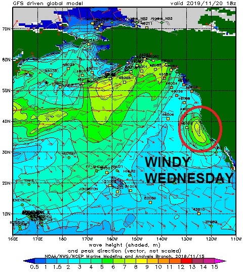
More wild & woolly weather & waves are on tap to start the week.


First up is more NW wind/groundswell as another storm rolls into town on Monday. Look for head high NW on Monday but messy conditions and showers likely. Wednesday morning drops slightly with chest high sets before another NW groundswell arrives for overhead sets in the afternoon. That should last into Friday morning. After that, models show the Pacific taking a little breather. Make sure to check out Twitter/North County Surf if anything changes between now and then. 

BEST BET: 
Wednesday-Friday of next week looks to be the call as we should have new NW and no storms in sight. 

WEATHER:


This has been one heck of a start to our winter. After October and most of November left us high and dry, December has been unrelenting in the rain department. Last night and today saw more showers (1-2") and we've got more on the way next week. Before I get ahead of myself, the storm today will exit the region tonight and we'll have clear cool skies for the weekend. Then another storm looks poised to come ashore on Monday for another round of showers. At first glance, models don't show this storm being too big but we're still 4 days away and anything can change between now and then. After Tuesday of next week, high pressure should be in control and we're back to clear cool skies. 

NEWS OF THE WEEK:


Speaking of rainy weather, we're right in the middle of it if you haven't noticed already. Which is fine since I'm tired of hearing about droughts and wildfires. December happens to be our 4th wettest month (March is 3rd and January/February are basically tied for 1st and 2nd) which means there's plenty more coming. So where do we stand after today's rain for our annual averages?
  • Newport Beach: 4.55" so far. Compared to last year, we were at 5.54" (pretty impressive) and the average this time of year should be 3.29"
  • Oceanside: 5.56" so far. Compared to last year, we were at 3.94" which was still above the average of 3.14" this time of year. 
  • San Diego: 5.14" so far. Compared to last year, we were at 4.16". The 5.14" this year is almost 200% of our normal average of 2.75"
If next Monday's storm adds a little to the bucket (maybe 0.5"-0.75"), the totals above may be around 5" for Newport and 6" for Oceanside and San Diego. The yearly total for our rainy season is 13" for Newport/Oceanside and 10.5" for San Diego, so you can see we're about 1/2 way there with 3 more solid months of rain ahead of us...

PIC OF THE WEEK:


Random English secret spot #AD-4863.

Keep Surfing,

Michael W. Glenn
A Sight For Sore Eyes
Only 364 Days Until Xmas! 
A Dolphin In The Water And A Sea Slug On Land

Friday, December 20, 2019

THE Surf Report


Not exactly what I asked Santa for Christmas, but I'll take it. 

SURF:


Great week for surf. Again. Solid NW swell with offshore winds on Tuesday was replaced by more NW swell on Thursday and sunny skies. That NW peaked earlier yesterday but we have more coming. This morning has chest high+ sets then Saturday and Sunday looks pretty small but conditions are clean. 


Late Sunday starts to build slightly with chest high NW towards San Diego BUT... we've got more wet weather headed our way late in the day. Basically this morning is the call. Water temps are still high 50's and here's what going on with the tides and sun this weekend:
  • Sunrise and sunset are an equal 10 hours of sun this weekend:
    • 6:46 AM
    • 4:46 PM
  • And tides are pretty straightforward this weekend:
    • 5' at sunrise
    • 0' at lunch
    • 3' at sunset
FORECAST:
If you like rolling the dice when it comes to your surf sessions, then next week is for you. 


The building NW on Sunday gets a little bump on Monday for chest high sets then building more on Tuesday for head high+ surf. But that's accompanied by wind and rain. Xmas morning looks small (but who cares, you'll be eating fruitcake anyway), and then we get overhead stormy NW late Wednesday into Thursday. That is joined by, you guessed it, potentially more wind & rain! 


Further out, models show more head high+ NW arriving next weekend. And who knows- maybe more wind & rain if we're unlucky! Just make sure to have a flexible schedule over the holidays and you should be able to get some surf between the squalls. Make sure to check out Twitter/North County Surf if anything changes between now and then. Which it will of course.

BEST BET: 
Tough call since there's plenty of surf coming but also wet weather. If you can find a sliver of calm winds, then maybe Monday/Tuesday or Thursday/Friday.

WEATHER:


No reason to read this section since I already spilled the beans above. But if you're a bookworm, then here goes: Nice weather is on tap for today into Saturday before the storm track finally lowers to Southern California again late on Sunday. Looks like showers will occur by evening and continue through Monday. Christmas morning should be clear and cool before our next storm arrives late Christmas night. After that it's anyone's guess. None of these storms look to be big but it will benefit our rainy season. Rainfall totals for the week should be around 1 1/2". 

NEWS OF THE WEEK:


I’m always trying to find a silver lining. Like when the surf is crowded- it’s just a chance to make more friends, right? Or when the wind is howling onshore- it’s gotta be offshore somewhere?! And the earth heating beyond our control- it’s great for boardshort sales! So to all you surf companies out there, here’s more good news: November 2019 was 2nd hottest on record for the planet (but polar sea ice coverage shrank to near-record lows). Our fellow surfers at the National Oceanic and Atmospheric Administration (NOAA) can elaborate:

Moreover, both the season (September through November) and the year to date (January through November) were each the second hottest in recorded history, according to scientists at NOAA’s National Centers for Environmental Information.

The exceptional heat also was felt at both ends of the world: Sea ice coverage across the Arctic and Antarctic oceans fell to near-record lows in November.

Here’s more from NOAA’s latest monthly global climate report:

The average global land and ocean surface temperature for November 2019 was 1.66 degrees F (0.92 of a degree C) above the 20th-century average and the second-highest November temperature on record, just shy of November of 2015. In fact, the world’s five hottest Novembers have all occurred since 2013.

The average global sea surface temperature in November was 1.39 degrees F (0.77 of a degree C) above average — the second-highest temperature for November on record, behind November 2015.

The year-to-date global land and ocean surface temperature was 1.69 degrees F (0.94 of a degree C) above the 20th-century average, which made it the second-warmest period of January through November in the 140-year record — just behind the same period in 2016.

The season (autumn or spring, depending on the hemisphere) saw an average global land and ocean temperature 1.69 degrees F (0.94 of a degree C) above the 20th-century average of 57.1 degrees F (14 degrees C). It was the second-hottest September-through-November period on record behind 2015.

More notable climate events from this report:

Sea-ice coverage shrank to its second-lowest size on record for November in both the Arctic and Antarctic behind that observed in November 2016. Arctic sea ice coverage was 12.8 percent below the 1981–2010 average, while the Antarctic coverage was 6.35 percent below average.

Continents and island regions sweated it out: It was the hottest November on record for South America, Africa and the Hawaiian Islands. The Caribbean had its second-hottest November, and Europe had its seventh-hottest on record.

Warming of the ocean continued: The world’s average sea surface temperature ranked second warmest for the year to date — just 0.05 of a degree F (0.03 of a degree C) cooler than the record-breaking year of 2016.

PIC OF THE WEEK:


I know surfing in and around the Arctic Circle is all the rage right now but besides the cold water and ice cream headaches, there's a million other problems. Instead of Great Whites, you have Orcas hunting you down. Or bears ripping through your lunch on the beach, And the occasional iceberg in your way. Did I mention surfing in a 6/5/4 with 5 mil booties, a hood, and gloves are mandatory? Not for me. Bring on global warming! (Just kidding). And for more pics of the Great White North, check out Daniel Russo's work here.

Keep Surfing, 

Michael W. Glenn
I've Been Really Good This Year
Tired Of Being Mentioned In The Tabloids
Own The Dubious Record Of 128 Interferences On The World Surf League

Thursday, December 12, 2019

THE Surf Report- Early Edition


Xmas has come early. 

SURF:
Surfing has to be the most frustrating sport there is (besides golf). I was pulling my hair out a couple months ago from the lack of surf and now the swells are growing like Rogaine (I should know). 


Solid surf over the weekend slowly subsided mid-week but were building again tonight with shoulder high surf from the NW. For Friday, I'll be activating the EBS again (Emergency Boardriding System for you non-surfers), so look for the NW to continue to build with overhead sets by the afternoon and a couple feet overhead on Saturday.


On Sunday, we get another reinforcement from shorter interval NW wind/groundswell (this is the Jaws swell from today's contest) for overhead++ surf (and bigger in SD). We may though have a weak cold front move through late Saturday/early Sunday that could put some wind bump on the swell. All in all, heaps of surf this weekend if you dodge the wind. Water temps are high 50's and here's what going on with the tides and sun this weekend:
  • Sunrise and sunset are:
    • 6:43 AM
    • 4:44 PM

  • And tides are all over the place this weekend:
    • 4' at sunrise
    • 6' mid-morning
    • -1' at sunset
FORECAST:
After a firing weekend of surf, the NW holds on Monday morning for shoulder high surf but drops fairly quickly by the afternoon. 


We've got a lull mid-week then new NW is forecasted to arrive next Thursday for more overhead+ surf and then yet another solid NW late next Saturday the 21st. One thing to watch for though is models are hinting at more rain coming the 2nd half of next week so the new swells may have some wind bump. Regardless, get it while you can because it can't last forever! Make sure to check out Twitter/North County Surf if anything changes between now and then.

BEST BET: 
Late Friday/early Saturday before the wind gets on it or later next week- if the rain holds off...

WEATHER:


The peak of our great weather looks to be tomorrow with temps in the mid-70's at the beaches and plenty of sun. The weekend should be nice too but we're heading towards a cooling trend and a little more wind. As mentioned above, we may be headed towards a wet pattern again (which shouldn't be a shock since we're a week away from winter), so expect to see some more clouds towards Tuesday and maybe showers the 2nd half of next week. And if you're wondering where we stand with ran with the recent storm, Newport has 3.25", Oceanside has 4.6", and San Diego 4". All of this is 150-200% above average! 

NEWS OF THE WEEK:


The Earth’s coastal and polar areas are on thin ice, a new climate report warns, but San Diego may be in a better place than others to weather those changes if it acts swiftly, several authors said. Here's what the San Diego Union Tribune had to say:

“The Ocean and Cryosphere in a Changing Climate,” released last week by the Intergovernmental Panel on Climate Change, explored the effects of warming on the world’s oceans and frozen places. San Diego is grappling with rising seas, coastal erosion and marine heat waves, periods when seawater hits record-high temperatures. However, natural variability in the region’s sea level, ocean temperature and chemistry may position coastal cities to stay ahead of future changes, several authors said. Understanding the risks specific to San Diego can help with that.

“Every community has different vulnerabilities, so it’s useful to downscale these risks to your specific communities,” said Mark Merrifield, a contributing author of the report and director of the Climate Change Impacts and Adaptation Center at Scripps Institution of Oceanography in La Jolla. Besides the steady ocean warming, El Nino and La Nina cycles, as well as marine heat waves, have caused wild fluctuations in ocean temperature, the report stated.

“Marine heat waves, periods of extremely high ocean temperatures, have negatively impacted marine organisms and ecosystems in all ocean basins over the last two decades, including critical foundation species such as corals, sea grasses and kelps,” the report states. San Diego experienced that firsthand starting in 2013, when parts of the Pacific soared up to 9 degrees Fahrenheit above normal under the influence of “the blob,” a vast patch of warm, stagnant water that lingered off the West Coast for years. The warm water dampened normal upwelling of cold, nutrient-rich water from the deep ocean, and the effects rippled across the region, authors said.

“When waters become warmer, and they already are, there’s less nutrients, so there’s less phytoplankton,” said Lisa Levin, an author of the study and a professor of biological oceanography at Scripps. “They are the plants of the ocean, they’re fixing carbon and they feed the rest of the ocean, so there’s less food. That trickles down through the food web to fish and mammals. And we’ve some hungry mammals in the last five years.”

Starving sea lion pups stranded in record numbers between 2013 and 2017. Whales swam closer to shore, where there was better food supply, said Raphael Kudela, an author of the report and professor of ocean sciences at UC Santa Cruz. That’s good for whale-watching, but bad for whales, which risk ship strikes and entanglement closer to the coast, he said. The change in temperature pushed some species northward, so market squid, normally a mainstay for Southern California, were being caught north of San Francisco, he said, while yellowfin tuna moved from Baja to San Diego. Warmer water also created conditions for toxic algal blooms, which can sicken animals and people.

“The big heatwave in 2015 resulted in the big harmful algal bloom and the closure of the Dungeness crab fishery” on the West Coast, Kudela said. “We are concerned that this could be the new normal. We’ve got another marine heatwave starting right now, so come spring 2020, are we going to see another harmful algal bloom?” Marine heat waves are likely to become more frequent and intense in coming years, “pushing some marine organisms, fisheries and ecosystems beyond the limits of their resilience,” the report warned. Kelp forests, one of San Diego’s signature habitats, are vulnerable to changes in water temperature, it stated. But San Diego’s coastline already experiences seasonal variations in oxygen and pH levels, so some marine life may be better able to cope as climate change alters ocean chemistry, Levin said.

Along the West Coast, low oxygen areas are a natural feature of the ocean environment, she said. Although many animals avoid the “oxygen minimum zones,” some commercial fish, including Dover sole and black cod, have learned to live with them. Those low-oxygen zones, found at depths of 300 and 3,000 feet, result from upwelling cycles common to our coastline. Seasonal winds fan the California coast, churning up water that’s high in nutrients, but acidic and low in oxygen, Levin said. Ocean acidification can interfere with shellfish development and may affect fish growth. Although this change could be devastating to coastal fisheries such as oysters, there is great genetic variability in different organisms’ ability to tolerate it, and some local species are likely to hold fast, Levin said.


Moreover, oxygen and pH levels shift during naturally occurring El Nino and La Nina events, Levin said, so Southern California ecosystems already have some ability to withstand those changes. “Some of the species in California will be more tolerant of climate changes than the species in other areas of the ocean, probably,” Levin said. As melting ice drives rising seas, coastal communities including San Diego will encounter more frequent and severe flooding, scientists said. Runoff from melting glaciers in Greenland and Antarctica, along with expansion of the warming ocean water, has doubled the global rate of sea level rise, according to the report.

"(High) water levels that used to occur once a century will occur annually or more often in many places, and San Diego happens to be one of them,” said Michael Oppenheimer, a lead author of the report and professor of geosciences and international affairs at Princeton University. Those effects are most likely to occur in low-lying areas such as Imperial Beach, and during certain inauspicious conditions, Levin said. “When high tides interact with storm surge, we know that there’s more coastal flooding,” she said. Nonetheless, much of San Diego’s infrastructure is built at higher elevations, so the region may have a better buffer than areas such as San Francisco, where many buildings are constructed on low-lying stretches of reclaimed land, said Merrifield, professor of oceanography at Scripps.

“Coastal flooding is certainly a problem in certain low-lying areas, but San Diego does benefit from having most of the built environment well above sea level,” he said. Although San Diego may be more resilient to flooding than some parts of the state, its more immediate threat is bluff and beach erosion, Merrifield said. “It might not mean that you’ll get flooding, but there will have to be attention paid to keeping sand on a beach,” he said. Early warning systems will be important to heading off threats, said So-Min Cheong, a professor of geography at the University Kansas, and an author on the chapter on risk management. By better predicting events such as marine heat waves, officials can manage fisheries to prevent over-fishing, or shore up marine protected areas to defend existing fish stock. Planners should work with developers to ensure that new housing can withstand risks of flood and erosion, she said.


“They need to be engaging with communities, with the construction sector, to redesign the houses, to raise houses up and make them flood-proof,” Gheong said. One of the more upbeat notes in the report concerns the role of “blue carbon,” the restoration of marine plants to help slow climate change and safeguard coastlines. Kelp forests, sea grass beds, mangroves and wetlands all sequester carbon, shelter young fish, balance ocean chemistry and buffer inland areas, scientists said. “Sea grass beds and kelp are generally a net sink for carbon,” Kudela said. “They adjust the pH of the water so you don’t have to. If we protected these areas and helped them expand, we can mitigate the effects of ocean warming and de-oxygenation.” Besides updating the status of the Earth’s oceans and ice, the authors aim to lay out a choice.

“The report makes really, really clear, that if we act now and take on mitigation, we can limit the results of climate change,” Levin said. “And things can be really severe and catastrophic in the future, with a lot of loss of life and money, if we don’t act.”

PIC OF THE WEEK:


How's that little community with it's own private left point? Whatever the HOA dues or Mello Roos are, I'm paying it. 

Keep Surfing, 

Michael W. Glenn
Stellar
Still Believe In Santa
George Jetson Just Shaped Me A Board That Goes From 5'6" to 7'6" With The Push Of A Button

Thursday, December 5, 2019

THE Surf Report- Early Edition


And we're back in 3, 2, 1...

SURF:
And wouldn't you know it; that the week that I'm gone in Yosemite for Thanksgiving, it's pumping and I don't activate the Emergency Boardriding System. But fear not! We still have plenty of waves on the way. Enough so that I'm going to officially activate the Emergency Boardriding System this weekend. But first things first. Let's discuss the week that was.
 

We had plenty of surf over Thanksgiving and a back up swell to start our work week. Everything has backed off since then and today we were left with windy waist high+ NW.


Tomorrow looks to be the same but we do have a storm in the North Pacific today that is sending a healthy WNW swell for early Saturday through Sunday. Look for early on Saturday to start off in the chest to shoulder high range and then head high to overhead late in the day. That holds into Sunday. The only fly in the ointment is a weak cold front coming through this weekend that may kick up some SW winds. Not stormy- but just enough to put a bump on it. Make sure to get it early!  Water temps are barely holding on to 60 and here's what going on with the tides and sun this weekend:
  • Sunrise and sunset are:
    • 6:36 AM
    • 4:42 PM

And tides this weekend are:
    • 5' at sunrise
    • 0.5' after lunch
    • 3' at sunset
FORECAST:
The good swell over the weekend holds on Monday morning then it drops fairly quick on Tuesday morning to the waist high range. 


Wednesday afternoon we see more swell from the W for shoulder high surf and bigger in SD by Thursday. 


After that, models show another large storm on the charts which may give us overhead+ surf again towards the 14th. Hopefully the rain will hold off until then. Make sure to check out Twitter/North County Surf if anything changes between now and then.

BEST BET: 
Late Saturday/early Sunday with well overhead WNW swell, next Wednesday/Thursday with fun W swell, or bigger WNW swell towards the 14th...

WEATHER:


Looks like our heavy rain is over for the time being. We have one more weak cold front looking to move through Saturday/Sunday with just a chance of light showers. That should exit by Monday with cool sunny skies to start the week. High pressure looks to be in control next weekend with above average temps and plenty of sun to dry things out. 

NEWS OF THE WEEK:


I know it's been said a thousand times already, but as the earth continues on this warming trend, it really does seem like our storms are less frequent but more powerful when they do arrive. Take for example the latest round of rain we just received. After not seeing anything for over 6 months, we should have seen a couple showers in October and maybe some real rain in early November to start the rainy season. But NOOOO, the atmosphere held off until late November then WHAM! hit us with almost 3" of rain over the Thanksgiving holiday and 1" yesterday. So to officially start the season, we received around 4" along the coast in a week. Now that's impressive. Some ski resorts in California and Utah even had to delay their openings until late November because of the lack of snow. And then they had too much over Thanksgiving! Go figure. So where do we stand today with the start of our wet season? Here's the totals so far:
  • Newport Beach: 3" so far. 150% of normal. In comparison to last year's above normal wet winter, we only had 2.3" by this time.
  • Oceanside: 4.3" so far. 231% of normal. Last year at this time we only had 1.1"...
  • San Diego: 3.9" so far. 224% of normal. And last year at this time we had 1.38"
If you'll recall, we should be in a neutral state this winter- no La Nina and no El Nino. So we're off to a good start. BUT... we were below average in rainfall for October and the beginning of November- so anything can happen. 

BEST OF THE BLOG:


As you may know, I'm part of a group called the North County Board Meeting. Our goal is to strengthen our community by supporting local businesses, networking, charitable work, and finding an excuse to surf! Next Wednesday, December 11th happens to be our 5th annual holiday party at Priority Public House in Leucadia at 5:30 PM. And is the case in year's past, we'll be having a toy drive that will benefit the Community Resource Center and their annual holiday basket program. They provide food, clothing, blankets, toys, and household essentials to over 1,650 local families in need this holiday season. 

The North County Board Meeting is upping the ante this year and are aiming to gather 100 NEW TOYS to help families in north county San Diego and we'd like for you to join us. If you can't make the event, no problem, you can drop off a new unwrapped toy at a couple locations from now until Thursday, December 12th:
  • EPK Collection, 505 N Hwy 101, Solana Beach
  • Agency 73, 244 N Coast Hwy 101, Encinitas
And if you CAN make the event at Priority Public House, we'd be stoked to share a cold one with you while telling some tall tales about our last surf session. Any questions, email me of course at northcountyboardmeeting@gmail.com

Thank you for the support and we hope to see you there!
 
PIC OF THE WEEK:


My top 10 LEAST favorite things in surfing:
  1. sharks
  2. crowds
  3. onshores
  4. stingrays
  5. flat days
  6. snakes (drop-ins, not the animals)
  7. Ok- the animals too (deadly seasnakes)
  8. getting injured by your board (fin cuts, hit to the head, landing on your board, etc)
  9. not bringing the right board for the conditions
  10. and this- paddling for a wave, missing it, and turning around to see this unload on your head
Keep Surfing, 

Michael W. Glenn
Been Called Everything From Extraordinary To Extra Ordinary
My Greatest Hits Album Is Dropping In Time For The Holidays! 
4/3 Fullsuits Are Overrated. I'm Wearing A 7/2 This Winter

Thursday, November 21, 2019

THE Surf Report- Early Edition


Life is funny sometimes. 

SURF:
For MONTHS there were no waves or weather to get excited about. Now there's too much to fit into one email. But I'm going to try. So here goes: 


Last weekend we had fun NW/SW swells for shoulder high sets and that slowly tapered off during the week. On Tuesday night, our first real storm of the season rolled into town and all heck broke loose with an inch of rain and 8' stormsurf. Today was cleaner (wind-wise) but the water was filthy. Best bet this weekend is to stay out of the surf until at least Sunday. 


BUT... we have a fun chest high+ NW headed our way on Saturday- so take your chances. Sunday the new swell drops slightly but we'll have great weather. Water temps are in the low 60's and here's what going on with the tides and sun this weekend:
  • Sunrise and sunset are:
    • 6:25 AM
    • 4:45 PM
  • And tides this weekend are:
    • 6' at sunrise
    • 0' after lunch
    • 3' at sunset
FORECAST:
Monday starts off slow with nice weather and waist high NW. 


The storm track seems to be active in the near future so we start to see new chest high NW arrive on Tuesday with our last good day of weather. On Wednesday the rain returns along with building head high NW. That lasts into Gobble Gobble day. 


Next weekend should clean up with chest high surf and if the models are correct- more good NW around the 1st- if the weather cooperates too. Make sure to check out Twitter/North County Surf if anything changes between now and then. 

BEST BET: 
Saturday with fun NW and great weather or Tuesday afternoon with new NW and the last of the good weather. 

WEATHER:


Not a bad way to start our rainy season. 1" of rain along the coast of SD, 4" in the local mountains, and Big Bear received 1/2 a foot of snow. This weekend high pressure is in control with clear cool skies. Early in the week looks nice still, then as mentioned above, we're due for another good storm Wednesday through Friday possibly. Since we're only at 30% of normal for our rainfall so far this season, it's a blessing- even though it's screwing up the surf. 

NEWS OF THE WEEK:


As reported in last week's THE Surf Report, we've got a mysteriously large blob of warm water off the coast of the western US. Scientists can't pinpoint the exact reason for the warming but it may be due in part to Global Warming. Each year, as humans emit billions of metric tons of CO2 into the atmosphere, nearly a third of the emissions ends up in the ocean, changing the chemical balance of the water. And as the climate changes, the ocean is also absorbing almost all of the Earth’s extra heat, melting ice that creates sea level rise, making the water uninhabitable for marine life, and changing the planet’s weather patterns. A new report from the IPCC, the UN panel that studies climate change, lays out exactly what’s at stake for the ocean as a result—and for humans, all of whom rely on the ocean either directly or indirectly. Here's what Fast Company magazine reported recently:

“What comes out of this report is that it’s going to hit us in so many ways,” says Mark Spalding, senior marine scientist for The Nature Conservancy, one of the organizations that contributed to the report. The litany of potential disasters from a changing ocean is horrifying: As the warming water melts ice sheets in Greenland and Antarctica, the sea level rises each year, putting hundreds of millions of people who live in low-lying coastal areas at risk of flooding. A warmer ocean supercharges hurricanes. Marine heatwaves can boost toxic algae and close fisheries. As the water absorbs CO2, it becomes more acidic, posing another threat to coral reefs. And all these impacts can exacerbate each other—coral reefs, for example, “play the role of a sea wall,” says Spalding. “They sit offshore like a barrier and they break waves before the waves get to land.” As storms get stronger, this natural protection is being lost at the same time.

For marine ecosystems, these threats are piling up on top of other human impacts. “A lot of the other damage we’ve done to habitats is making the threat of climate change worse,” he says. “We overfish, we damage coral reefs, we pollute. This idea that humans are adding to the problem comes out quite clearly in this report. The flip side to that is that we can do something about it. If we can reduce some of these parallel problems, we can at least buy ourselves some time to deal with the climate change piece of this.” The Nature Conservancy, for example, is working on projects to restore coral reefs and other marine ecosystems, as in a project in the Caribbean that created an insurance policy for coral reefs; hotels in the area pay a premium each month so that if a storm hits, the funding can immediately be used to rebuild the reefs to protect the hotels. Other projects are restoring mangroves, a coastal ecosystem that is uniquely good at sucking carbon from the air.

The biggest change that needs to happen, of course, is a move to a zero-carbon economy. “What happens depends on what decisions we make now and in the next few years,” says Spalding. “Do we follow a business-as-usual path? Or do we really knock it down and try to aim for [warming of just] 1.5 degrees?” The difference between limiting global warming to 1.5 degrees Celsius, instead of 2 degrees, might sound small. But it’s actually huge. “It’s startlingly different between one and the other. The lowest emission scenario is still talking about just one meter of sea level rise in a couple of hundred years’ time. With a high-emissions scenario, we’re talking about multiple meters of sea level rise, which frankly is curtains for entire nations—even wealthy nations and cities that are on the coast.”
PIC OF THE WEEK:


The west coast is finally coming to life. Like this gem between San Diego and San Francisco. If you want to know it's exact location though, make sure to head on over to www.secretspots.com and you'll find GPS coordinates, maps, and webcams, all free of charge.  

Keep Surfing, 

Michael W. Glenn
Enduring
Hulkamaniac
My Therapist Says It's Perfectly Fine That I Baby My Surfboards

Thursday, November 14, 2019

THE Surf Report- Early Edition


I'm THIS close to activating the Emergency Boardriding System...

SURF:

Finally some fun surf this week- with pesky afternoon NW winds- but I'll take it considering how small it's been the past 2 months. Early in the week we had fun SW swell and that was met by fun NW yesterday. Best spots had shoulder high sets and it was good to get off the groveller! For tomorrow morning, we have leftover SW/NW with chest high sets but by the afternoon we see signs of a new, good, NW swell. 


By Saturday morning we have head high sets here in north county SD and maybe an overhead set in south SD. And if that's not good enough, we've got a slight Santa Ana this weekend so conditions should be great through mid-morning. Sunday backs off slightly with shoulder high sets and head high waves in SD. Along with great weather again. All in all a fun weekend. Water temps are still in the low to mid-60's and here's what going on with the tides and sun this weekend:

  • Sunrise and sunset are:
    • 6:18 AM
    • 4:47 PM

  • And tides this weekend are:
    • 3' at sunrise
    • 5.5' mid morning
    • 0' at sunset
FORECAST:
Looks like the storm track is finally behaving but the reason I'm not activating the Emergency Boardriding System (EBS) yet is that there's a lot of variables right now. But before I get ahead of myself, let's take a look at early in the upcoming week: Monday will have leftover chest high NW swell and Tuesday starts to pick back up again from the NW with shoulder high sets late in the day. The fly in the ointment? We may have our first chance of showers Tuesday evening into Thursday morning. As that potential storm moves down the coast, the waves/weather will pick up along with it. 


Forecast charts are showing the potential for overhead storm surf on Wednesday. 


There's also some fun chest high late season SW swell headed our way on Wednesday too but the storm will make a mess of it. Thursday will be a transition day with leftover head high NW/SW and next Friday the 22nd may be clean with chest to shoulder high NW. 


And if the models are correct, we may get a solid overhead WNW next weekend. BUT... who knows what the weather will be like now that the storm track looks to be lowering. So now you know my dilema with the EBS- lots of surf coming but conditions may be questionable. Make sure to check out Twitter/North County Surf if anything changes between now and then. 

BEST BET: 
Saturday with fun NW and great weather. Or next Saturday with bigger NW and ??? weather. 

WEATHER:


Looks like the fog/wind is going away as high pressure is setting up shop this weekend. We'll have more sun tomorrow and lots of sun this weekend with temps in the high 70's. And wouldn't you know it, everything gets thrown out the window by Tuesday as the weather models show rain showers by Wednesday and lasting into Thursday. Depending if high pressure builds behind the storm, we could get nice weather next weekend or another shot of rain. I'm hoping for sunny skies of course if that solid swell arrives next Saturday...

NEWS OF THE WEEK:


Remember that weird and unusually warm pool of water off the west coast a few years ago? The one that scientists called 'The Blob' (https://northcountysurf.blogspot.com/2015/05/the-surf-report.html)? Well, IT'S BAAAAACK. Is this thing El Nino related? Is it Global Warming related? Is it Godzilla related?! I'll let the NOAA experts explain:

The Pacific Ocean is throwing a bit of a temper tantrum these days, but it’s not where you think it might be. Often we focus on the tropical Pacific Ocean because it’s where ENSO takes center stage, but currently temperature departures across the Tropics are pretty blah. Instead, for the past few months, it’s the North Pacific Ocean that pops out at you—a gigantic red sore that covers much of the eastern basin.  

The technical term is a Marine Heatwave. Marine heatwaves are considered prolonged, large-scale warm water events. Back in 2014-16, people started calling a very prominent North Pacific marine heatwave THE BLOB. Now, some people are saying this current event could be a return of the Blob. Blob is fun to say and simply rolls off the tongue, so we understand why it’s caught on. 
BUT! The problem is “Blob” is not that useful of a description. There’s no single fixed Blob. It would be like if we called every single hurricane, “Hurricane Dave.” Obviously hurricanes, like marine heatwaves, don’t always occur in the same place, at the same time, have the same magnitude, or even have the same areal coverage. In fact, an El Niño can result in conditions that would be considered a marine heatwave in the Tropics, but we would not call that area of warmth a “Blob.”  
Marine heatwaves can be a bit tricky to categorize because, like most phenomena in weather and climate, there are shades of grey. While marine heatwaves can be defined by many different physical properties (e.g. size, intensity, duration), there are no fixed set of impacts that will always result. At this point, it is too early to say if this heatwave might have major impacts on marine life and fisheries the way the last one did.  
The experts at NOAA (Michael Alexander at NOAA Earth Systems Research Lab and Michael Jacox and Nate Mantua, who are with NOAA Southwest Fisheries Science Center) have a lot of great information to share:

Q: So far, how different is the current marine heatwave (Blob Redux) from the one we saw in 2014-16 (The Original Blob)? 

Alexander: Marine heatwaves are usually identified by temperatures at the sea surface, which can be measured by satellites. Based on sea surface temperatures, the general pattern of the current heatwave does resemble the Original Blob.  However, generally, it is important to determine how deep the temperature anomalies (how much warmer or colder the temperature is relative to average) extend into the ocean. As Nate points out below, these anomalies are just near the surface off the US West Coast, so strong storms, which often begin this time of year, can quickly wipe out a heatwave.  In fact, we may have just started seeing this.  
Mantua: The biggest differences so far are in the depth and duration of the two events. The Original Blob lasted for multiple years and the warming eventually extended to more than 300 meters (~1,000 feet) below the surface across much of the Northeast Pacific.  In contrast, the current event has been with us for only a few months, and the extreme warming is confined to the top 30 to 50 meters (~100-150 feet). 


Q: Around the time the marine heatwave emerged in the North Pacific Ocean in 2014, there was an El Niño Watch.  How significant is ENSO in helping fuel marine heatwaves (or vice versa)?  

Alexander: The 2014 marine heatwave (Original Blob) started in the northeast Pacific. Recent studies suggest that air-sea interactions allow ocean temperature anomalies near Hawaii to move towards the equator. When warm temperature anomalies, including marine heatwaves, reach the equator they enhance the chance of an El Niño event in the following year. So the Blob may have contributed to the strong El Nino event that occurred in 2015-16.
While El Niño events occur in the tropical Pacific they influence the ocean and atmosphere in the North Pacific including sea surface temperatures. Generally, the winds are from the southwest near the US West Coast during El Niño which warms the underlying ocean, while ocean processes push the deeper cold water farther down, warming a very narrow region right near the coast. A full blown El Niño did not happen in 2014 but one did in the following winter, which likely contributed to the continuation of the marine heatwave when it was strongest near the West Coast.
Jacox:  In general, El Niño is a very prevalent cause of the marine heatwaves in much of the Pacific. Off the U.S. West Coast, El Niño events tend to produce warming by changing the wind patterns that typically cool the coastal ocean, and through an “oceanic teleconnection” where coastal trapped waves propagate northward along the North American west coast. The Original Blob wasn’t caused by El Niño, but the tropical warmth during the 2014-15 winter likely helped that heatwave persist and then the strong 2015-16 El Niño contributed to the extended warming as well.

Mantua: Georgia Tech Professor Emanuel Di Lorenzo and I published a study showing that the evolution and persistence of the Original Blob involved long-distance teleconnections between the North Pacific and Tropical Pacific that involved two flavors of El Nino. As Mike J. points out, the initial warming off the coast of the Pacific Northwest that first earned the “Blob” label wasn’t caused by El Niño. Instead, the atmospheric forcing that started The Blob in winter 2013/14 also contributed to the tropical warming in 2014, which persisted into 2015.  

Q: There are research studies that indicate that that marine heatwaves will become more frequent with climate change. How certain is this?  Could there be a human-caused thumbprint in recent events? 

Alexander: Most of the ocean has warmed over the past 50 years. This warming is projected to continue through the 21stcentury, especially off the northeast US coast. Nearly all computer model simulations of the future indicate the oceans will warm.  So relative to the present, marine heatwaves will become more frequent.  However, if one thinks of a heatwave as a short-term event relative to the mean temperature at that time, the frequency of marine heat could stay about the same but just happen in an overall warmer climate.
Jacox: What those studies show is that in a warming ocean, historical temperature thresholds will be exceeded more often. In other words, temperatures we currently consider extreme will become more common.  But that doesn’t mean marine heatwaves will necessarily change. One could think of it like sea level rise – just because the water gets higher doesn’t mean the waves are getting bigger. How marine heatwaves will change relative to the increasingly warmer temperatures is still an open question, and the answer will likely be different in different parts of the ocean. For marine species, both the warmer temperature and future marine heatwaves will be important. Their relative and combined impacts will vary among species depending on their exposure to warmer temperatures, their sensitivities, and their adaptive capacity.

Q: Perhaps the most important question of all:  If you got the Blob, Polar Vortex, and Godzilla El Niño into the ring, which one would win?

Alexander: My dog, which can eat just about anything and drink vast quantities of warm water.
Jacox: Trick question, it turned out that the Blob and Godzilla El Niño were on the same team.
Mantua: I’m with Mike and Mike on this one.
PIC OF THE WEEK:


The upside to Global Warming (if there is one)- in 20 year we'll be able to surf this spot in trunks! 

Keep Surfing, 

Michael W. Glenn
Cheeky
People Magazine's Sexiest Man Alive (Runner-Up)
Bought Lopez's House At Pipe So I Could Walk Out The Backdoor And Backdoor The Barrel At Backdoor