Thursday, November 30, 2017

THE Surf Report- Early Edition


Not taking it for granted.

SURF:
I’m definitely grateful for the lack of wind we’ve had lately and the fun surf. I know we need the rain but I’ll take clean conditions any day.


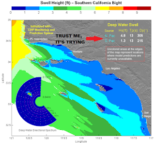
This past week we had some good NW (once the wind backed off Monday) and the crowds have been manageable. Today new NW peaked with head high sets and we’ll still have chest to shoulder high waves tomorrow.

We get a small reinforcement from the NW on Saturday afternoon for shoulder high sets again (better in SD) and that lasts into Sunday morning.


Water temps are hovering around 60 and tides this weekend are a mess; 6’ at sunrise, down to -1’ after lunch, and up to 2’ at sunset.

FORECAST:
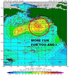
The Aleutians are still active and we have more NW headed our way.


First up is a shot of windswell/groundswell on Monday for head high+ surf as a cold front moves by to the N.


We also have smaller waist high+ SW underneath the bigger NW arriving on Monday but it will be lost in the shorter period NW.


After that, we have more late season chest high sets from the SW around the 9th.


And right on it’s heels is more NW for head high+ waves around the 10th. And forecast charts show more good NW after that…

WEATHER:


Lots of awesome sunsets and no rain in sight. As mentioned above, we have nice weather this weekend then a weak cold front moves by to the N on Monday. We’ll just see more clouds and breezy conditions- but no showers. After that, high pressure is forcasted to set up and we could have a moderate to strong Santa Ana offshore wind event. With the lack of rain, I hope not. Don’t need any fires around here.  If anything changes between now and then, make sure to keep up to date on the waves and weather at Twitter/North County Surf. 

BEST BET:
Saturday with nice conditions again and fun NW or next weekend with NW/SW combo and offshore winds potentially.

NEWS OF THE WEEK:


As you know, La Nina conditions set up in the equatorial Pacific this summer and it effectively shut down our hurricane surf for the West Coast. What does that mean on the opposite side of the US? The opposite of course- one heck of a hurricane season. Here’s the official report from the National Oceanic and Atmospheric Administration:


Today marks the official end of the 2017 Atlantic hurricane season, which matched NOAA’s seasonal predictions for being extremely active. The season produced 17 named storms of which 10 became hurricanes including six major hurricanes (Category 3, 4 or 5) – including the first two major hurricanes to hit the continental U.S. in 12 years.

Based on the Accumulated Cyclone Energy index, which measures the combined intensity and duration of the storms during the season and is used to classify the strength of the entire hurricane season, 2017 was the seventh most active season in the historical record dating to 1851 and was the most active season since 2005.

This year, three devastating major hurricanes made landfall (Harvey in Texas; Irma in the Caribbean and southeastern U.S.; and Maria in the Caribbean and Puerto Rico). Harvey was also the first major hurricane to hit the U.S. since Wilma struck Florida in October 2005. Additionally, four other storms hit the U.S., including Cindy in Texas, Emily and Phillipe in Florida, and Nate in Mississippi.


“This was a hurricane season that wouldn’t quit,” said retired Navy Rear Adm. Timothy Gallaudet, Ph.D., acting NOAA administrator. “The season started early with a storm in April and the peak of the season featured an onslaught of ten successive hurricanes. NOAA forecasters rose to this challenge to keep emergency officials and the public aware of anticipated hazards.”

“In six short months, the next hurricane season will be upon us,” added Gallaudet. “This is a good time to review and strengthen your preparedness plans at home as we continue to build a Weather-Ready Nation.”

The 2018 Atlantic hurricane season officially begins on June 1 and NOAA’s Climate Prediction Center will provide its initial seasonal outlook in May.

PIC OF THE WEEK:


What a reef break should look like.

Keep Surfing,

Michael W. Glenn
Mind-boggling
Harry’s Best Man
Shaping Organic Surfboards; Surf On It, Then Eat It

Thursday, November 23, 2017

THE Surf Report- Early Edition


Can’t believe I’m awake.

SURF:


I’ll make it quick here tonight as turkey makes… me … sleepy. Beautiful weather again this week and not much surf. 


Had a little NW fill in today for chest high sets at high tide and it continues to fill in overnight.


We also have a small SW filling in tomorrow and we’ll have fun chest high combo swell for the weekend. Weather stays nice tomorrow and Saturday then we have a weak cold front moving through Sunday/Monday- so winds may increase slightly as well as a return of low clouds- so the dreamy conditions will deteriorate slightly. 


Water temps have dropped a lot due to the AM offshore winds- down to the high 50’s- and tides this weekend are 3’ at sunrise, up to 4’ after lunch, and down to 2’ at sunset. 

FORECAST:
Monday starts off like a lamb then by the afternoon it comes in like a lion. 


A good storm forming in the Aleutians this weekend will send solid overhead sets to SD Monday afternoon into Tuesday morning. 


That drops off pretty quickly by Wednesday but by Friday we have more chest high NW arriving. 


Forecast charts also show more NW arriving around 12/3 with fun SW at the same time for shoulder high swell. Looks to be fun the next 10 days with late Monday/early Tuesday being the biggest.

WEATHER:


One last day of hot weather tomorrow will be replaced Sunday/Monday by cooler temps around 70 and low clouds. High pressure will set up again Tuesday through Thursday for a moderate Santa Ana offshore wind event and temps back in the high 80’s. Models are hinting at cooler weather again late next weekend.  If anything changes between now and then, make sure to keep up to date on the waves and weather at Twitter/North County Surf. 

BEST BET:
Tuesday morning with solid NW and offshore winds.

NEWS OF THE WEEK:


As a kid, I always seemed to notice that the usual weather pattern (if there is such a thing) for this time of year is a weak cold front with light precipitation rolling through around mid-October (I remember this because I used to freak that Halloween could get rained out), then a couple more could fronts in November (usually one solid one), then a few storms in December, and then the bulk of our rainy season January through March. Why do I mention this? Because we really haven’t received any rain in October or November this year- which should be expected for our La Nina weather pattern this season. So where do we stand for precip so far this season (which is from October 1st to September 30th)?

· Newport Beach: 0” so far. Normal is 1.57”. FYI: Total expected for the season is 13.3”
· Oceanside: 0.01” so far. Normal is 0.66”. Total expected is 13.66”
· San Diego: 0” so far. Normal is 0.30”. Total expected is 10.34”

So there you have it. A bad start to our rainy season. Sure glad we had a couple good years in ’15 and ’16 to fill those reservoirs.

PIC OF THE WEEK:


I’m thankful for empty lineups. Happy Thanksgiving everyone.

Keep Surfing,

Michael W. Glenn
Beloved
Thankful I’m Not A Turkey

Surfer Poll Runner-Up ’84-’88, ’92-’93, ’97, ’99, ’01-’07, ’09, ’11, ’13, ’15-‘17

Thursday, November 16, 2017

THE Surf Report- Early Edition


I’m excited for winter.

SURF:
I’m excited for winter. The big surf, the storms, finding parking at the beach, sessions in which you’re the only person out, river mouth sandbars coming to life, and on and on and on. In the meantime though, we have to contend with November.


Don’t get me wrong- we had some fun surf the past couple weeks-  but we’re still missing some solid surf. Can’t wait to shelve the 5’10” and pull out the 6’10”. For this weekend, we just have background NW/SW  for waist high waves and best combo spots will have inconsistent chest high sets. Please note- we also have a weak cold front moving by to the N tomorrow and we may have some NW winds in the afternoon. By Saturday and Sunday though, winds should back to normal.


Water temps are in the low 60’s and tides this weekend are pretty simple; about 6’ in the morning and almost -1’ late in the afternoon.

FORECAST:
Mainly small NW/SW early next week for waist high+ surf and clean conditions.

Models show a little storm in the Aleutians taking shape this weekend which would give us waist high+ NW next Wednesday.


We also had a little storm off Antarctica yesterday which is also sending us waist high SW for Thanksgiving.


And after that, forecast charts show another small NW arriving next Friday for chest high sets.

And if the charts are correct, we have more chest high NW arriving around the 27th. Long story short, little swells off and on the next 10 days. So keep riding the 5’10”, not the 6’10”

WEATHER:


Not a whole lot going on out there. As mentioned above, a weak cold front is coming through Northern California tonight which may bring a sprinkle here on Friday. NW winds may pick up slightly too. Once that rolls through, sunny skies prevail for temps in the low 70’s this weekend then high pressure sets up shop early next week and temps towards Thanksgiving could be 80 at the beach and light offshores. Typical for fall, right? If anything changes between now and then, make sure to keep up to date on the waves and weather at Twitter/North County Surf. 

BEST BET:
Thanksgiving weekend with small but fun combo surf and good weather.

NEWS OF THE WEEK:


You might have read a few years back that there used to be a GIGANTIC shark in prehistoric times called the Megalodon. Large Great White Sharks are 20’. Megalodons were 60’. Holy crap. But thankfully, that was millions of years ago and we don’t have to deal with prehistoric sharks anymore, just Great Whites. Not so fast. Scientists in Europe discovered a “living fossil” called the Frilled Shark (‘living fossil’ because evidence of its existence dates back to at least 80 million years ago). This summer, researchers found one alive and thriving off the coast of Portugal, uncovering more clues about the resilience of this ancient sea creature. I’ll let Newsweek take it from here:

The researchers who discovered the shark off the Algarve coast were working on a European Union project in the area, the BBC reported. The goal of the project was to "minimize unwanted catches in commercial fishing," the researchers told SIC Noticisas TV, as the BBC noted, but the team unknowingly unearthed one of the rarest and most ancient animals on the planet.

Scientists believe the frilled shark has remained the same, both inside and out, since the Cretaceous Period, when the Tyrannosaurus rex and Triceratops still roamed the planet. The creature, known by scientists as Chlamydoselachus anguineus, is incredibly simple and unevolved, most likely due to the lack of nutrients found in its deep-sea dwellings. A Japanese study of the shark found in Suruga Bay, Japan, revealed that its diet is 61 percent cephalopods—the class to which squids and octopus belong.


This deep-sea dweller is usually found between 390 and 4,200 feet below the surface, which is why it’s rarely seen and wasn’t even discovered before the 19th century (despite being around long before humans).

The shark caught this summer measured around 5 feet in length, but at their longest, they can be around 6-and-a-half feet, IFL Science reported.  Another study of a Suruga Bay inhabitant showed that frilled sharks may also have the longest gestation period of any living creature, 42 months.

Its name may sound unfitting for a beast that swims the deep seas, but as Mental Floss explained, the frilled shark is named after its gills. Pretty much all other sharks have separate gills, but the frilled shark’s first pair of gills stretch all the way across its throat. In total, the shark has six pairs of gills that have “frilly” edges.

The shark also has a unique mouth shape. Its jaw has more than 300 teeth neatly lined in 25 rows that, according to professor Margarida Castro of the University of the Algarve, are specifically designed to help it “to trap squid, fish and other sharks in sudden lunges,” The Portugal News reported. It’s lined with spines called dermal denticles that, combined with the teeth, give the mouth an all-around frightening look.

It’s unlikely you will ever come face-to-face with a living frilled shark. But if you do, it’s safe to say: Keep as far away as you can, and whatever you do, try to avoid its ferociously awesome jaw.

PIC OF THE WEEK:


When the craft beer craze took of a few years ago, the term ‘growler’ was in everyone’s vocabulary. For us surfers on the other hand, that word has been around since the 50’s, as evident by Shark Island here.

Keep Surfing,

Michael W. Glenn
First and Foremost
A Toss Up Between Blake And I
Lost The Triple Crown Last Year Because I Hired Bob Baffert As My Trainer, Not Ross Williams

Thursday, November 9, 2017

THE Surf Report- Early Edition


Impatient.

SURF:
Are you the type of person that on Thanksgiving Day, you sneak in the kitchen and pull a little piece off the old bird before everyone is served? Or maybe open a present on Xmas eve? If so, I’ve got an early holiday treat for you this weekend. But before we get ahead of ourselves, let’s have a look at the past week. 


Not much swell in the water and the water temps dropped, but darn those sunsets were nice. Today we started to see signs of new SW and NW filling in on our buoys. 


For Friday, look for both swells to fill in even more for head high sets. As usual, the NW will be bigger in SD and the SW bigger in OC and here in N county SD we’ll see a combo of the NW/SW. Looks like a good weekend of surf with peaking NW on Friday, peaking SW on Saturday, and fun leftover chest high+ surf on Sunday. 


Water temps have dropped to the low 60’s and tides this weekend are pretty mellow: 4’ at sunrise, down to 2’ mid-morning, and up to 4’ again at sunset. 

FORECAST:
After the weekend’s fun waves, the SW lingers for a few more days in the waist to chest high range.


We get a small reinforcement from the NW on Wednesday for waist high+ surf then another SW shows up on our beaches next Thursday the 16th for shoulder high sets. Nothing big for the next week but plenty of rideable waves.

WEATHER:


Low pressure is anchored off the Pacific NW and high pressure is sitting off Cabo. So where does that leave us? Somewhere in-between. That means typical low clouds/fog in the nights/mornings and temps around 70 at the beaches. No rain is in our sights yet thanks to La Nina. If anything changes between now and then, make sure to keep up to date on the waves and weather at Twitter/North County Surf. 

BEST BET:
Friday through Sunday. Another weekend in which the lawn won’t get mowed I guess.

NEWS OF THE WEEK:


Recently I reported on our feeble hurricane season (http://northcountysurf.blogspot.com/2017/10/the-surf-report-early-edition.html) and most likely it’s demise due to the building La Nina this past summer into early fall (http://northcountysurf.blogspot.com/2017/09/the-surf-report-early-edition_21.html). As our waters continue to cool, I’m pretty confident we won’t see any more hurricanes before the season ends November 30th (or the rest of 2017 for that matter). 


The National Hurricane Center in May predicted 14–20 named storms (in which 16 actually happened), 6–11 hurricanes (of which 9 happened), and 3–7 major hurricanes (of which 4 happened). Pretty average by all accounts. And unfortunately, we only had 2 storms with winds over 125 mph (Fernanda and Kenneth) and they both went due W away from us resulting in no real surf. 


Now winds of 125 mph sounds impressive (category 3 on the Saffir-Simpson Hurricane Scale) but how does this season’s Hurricane Fernanda (Category 4) and Hurricane Kenneth (Category 3) stack up to the strongest East Pacific Hurricanes of all time? Let’s first have a look at the Saffir-Simpson Scale:


As far as the strongest storms on record in the East Pacific (all Category 5’s mind you), here’s the top 10:

                10. Ioke in 2006: 160 mph winds
                9. Hernan in 2002: 160 mph winds
                8. Elida in 2002: 160mph winds
                7. Guillermo in 1997: 160mph winds
                6. Gilma in 1994: 160mph winds
                5. Ava in 1973: 160 mph winds
                4. Kenna in 2002: 165 mph winds
                3. Rick in 2009: 180 mph winds
                2. Linda in 1997: 185 mph winds
                1. Patricia in 2015: A whopping 215 mph winds (For more on Patricia, check it out here). 

The Saffir-Simpson scale basically is in 20 mph increments. Since we normally don’t have storms over 156 mph (Category 5), it would be foolish to make a scale that was Category 6, Category 10, Category 20 and so on. BUT… technically Hurricane Linda had peak winds of 185 mph (Category 6?) and Patricia was 215 mph (Category 7 maybe?). Crazy. What should also be noted is that out of the top 10 storms, 8 of them occured in the last 20 years (and Gilma would have been 9 but was in 1994). One theory of course is the warming earth is fueling the hurricanes. If that’s the case- fine with me- as long as the storms don’t hit anybody…

PIC OF THE WEEK:


Besides deep sea diving in my personal sub, my other hobby is photography while hang gliding. Amazing considering that I’m claustrophobic, afraid of heights, and creeped out by shutterbugs.

Keep Surfing,

Michael W. Glenn
Like A Boss
Only Deal In Bitcoin, Black Cards, And Doubloons

For Safety Reasons, I Wear My Inflatable Vest Now From 2’-20’