Thursday, December 30, 2021

THE Surf Report


2022 Is Lookin' Up! 

SURF:


Hope Santa didn't bring you a surfboard for Christmas 'cause you've probably had a hard time finding waves to ride it on. But fear not! 2022 is looking up! But we have to get through 2021 first. 


On that note, we've got some leftover waist high sets from SW/NW windswells for Friday but may see a little more NW groundswell late in the day and into Saturday morning for chest high sets towards SD. For Sunday- not so much. And here's the tides, sun, and water temps for the next few days:
  • Sunrise and sunset:
    • 6:51 AM sunrise
    • 4:54 PM sunset
    • and just like that- the days are getting longer
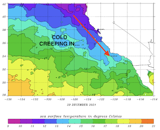
  • Water temps are feeling like winter (because it is) clocking in at a chilly 58 degrees
  • And the most exciting thing this weekend?... THE TIDES! Check these babies out:
    • a HUGE 7' high tide around 7:30 AM
    • DROPPING ALMOST 9' to a -2' around 3 PM. That's over 1' an hour! 
    • and back up slightly to 0' at sunset
FORECAST:


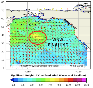
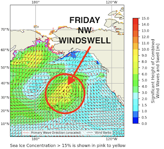
As mentioned in last week's THE Surf Report, high pressure has basically been above Hawaii the past month so storms that try to form off Japan get pushed into Alaska/British Columbia instead of roaring through Hawaii and aimed at California. With that being said, let's talk about next week. 


Looks like one last storm will form off British Columbia and a steep angled NW will fill in Wednesday for chest high sets towards SD. 


Behind that, we could see a real WNW groundswell for chest high surf around the 9th with shoulder high waves in SD. 

And after that, models show a slightly better WNW towards the 11th for shoulder high waves in N County SD and head high in SD. Keep your fingers crossed that we're finally on track to see some groundswells around here- and rideable waves for winter 2022. 

WEATHER:


Did you enjoy the rain? Good, 'cause it looks like it's done for the near future. If recent history is any indication- wet October, dry November, wet December- we'll go dry for the month of January. In the short term, look for cool sunny skies most of next week with temps in the low 60's. If anything changes between now and then, make sure to follow North County Surf on Twitter!

BEST BET:

Late Friday/early Saturday and Wednesday small NW groundswell. Or hold your horses until the 9th and 11th with fun WNW groundswell finally. 

NEWS OF THE WEEK:


Based on the past week's downpours, how did we do to help our drought situation? Here's the latest:
  • Newport Beach:
    • 2.37" before Xmas (92% of normal)
    • 3.21" of rain the past week
    • new total of 5.58" (169% of normal) 
  • Oceanside:
    • 3.08" before Xmas (108% of normal) 
    • 2.19" of rain the past week
    • new total of 5.27" (158% of normal)
  • San Diego:
    • 2.11" before Xmas (93% of normal)
    • 1.48" of rain the past week
    • new total of 3.59" (124% of normal)

As mentioned above, it wouldn't surprise me if we went somewhat dry in January as our weather lately has been all or nothing. But the good news is, January is typically our 2nd wettest month for San Diego- so even less than normal rainfall should wring out a few showers here and there. And in case you're wondering, here's our typical rainfall for SD based on average totals:
  1. February 2.25"
  2. January 2"
  3. March 1.75"
  4. December 1.5"
  5. November 1"
  6. April 0.75"
  7. October 0.5"
  8. September 0.25"
  9. May 0.25"
  10. June 0.1"
  11. July < 0.1"
  12. August < 0.1"
As you can see above, at least we have January, February, March, and April rainfall to potentially look forward to. 

PIC OF THE WEEK:


This treacherous right barrel in Canada is named Drake's Point. Popular to contrary belief though, it is not named after English explorer Sir Francis Drake, but rather Toronto's gift to modern music, Aubrey Graham. (Nice, for what)?!

Keep Surfing, 
Michael W. Glenn
Prominent
Could Do This In My Sleep
Haven't Missed A Day Of Surfing In 37 Years

Thursday, December 23, 2021

THE Surf Report- Early Edition


Wintertime And The Livin's Easy

SURF:


Besides the cold water and cold air temps, I'd say the last days of fall looked like summer around here as small waves and sunny skies greeted us this week. But as you're reading this, you probably noticed we're transitioning to winter and not a moment too soon. We've got a storm barreling down upon us today and it's going to increase our surf- along with the winds. 


For tonight, look for messy conditions and chest high+ surf from the NW. Friday isn't much better as we'll have jumbled conditions, head high NW, and dirty water. Saturday the surf backs off to the waist to chest high range- but the water will be suspect. Sunday should be jumbled again from another cold front and back to shoulder high sets from the NW; a lot going on this weekend. And here's the tides, sun, and water temps for the next few days:
  • Sunrise and sunset:
    • 6:49 AM sunrise
    • 4:49 PM sunset
  • Water temps are barely hanging on to 60 degrees
  • And tides aren't doing much this weekend:
    • about 2.5' at sunrise
    • up to 4' midday
    • and down to 0.5' at sunset
FORECAST:


We'll see more NW increasing late in the day on Monday to the waist to chest high range but that's due to another storm heading our way on Tuesday. So look for the surf to pick up again from the NW in the head high range BUT... conditions may be messy yet again. Surf drops fairly quickly Wednesday/Thursday BUT... models show another storm headed our way for New Years Eve?! 


If so, the NW may pick up again in the shoulder high range (and suspect conditions). 


In regards to all these storms, the ideal track is for them to form off Japan, roar above Hawaii, and aim swell towards California from a W or WNW directions. That way we get some good clean groundswell before the storm arrives. The recent storms though have been blocked off Japan by high pressure under Alaska. So we're left with storms forming off the British Columbia coast and racing towards us from the NW. Three issues with that:
  1. The storms are too N and can't wrap into Southern California, losing energy.
  2. The storms don't have time to form clean groundswells- rather short period NW.
  3. And when the swell does arrive- it's met with wind and rain here.
Hopefully high pressure off Alaska breaks down later this winter.

WEATHER:


This La Nina is turning out to be a dud (which is a good thing). We're due for another bout of rain tonight- and if the models are correct- through the first of the year. First up is the rain moving in from the N today that will steadily increase into Friday morning. We might see a solid 1 1/2+" from this. We get a slight break Xmas morning then the rain increases again late in the day into Sunday morning. This will be less of a storm but maybe we'll squeeze out another 1/2". After that, it's cool and cloudy then models show another round of rain towards Wednesday (maybe 1/2)". All in all, we could see 2+" of rain and temps in the mid-50's during the day and mid-40's during the nights. And forecast charts show more rain New Years?! Take all of this with a grain of salt though as these storms could arrive earlier/later or have more/less rain. If anything changes between now and then, make sure to follow North County Surf on Twitter!

BEST BET:
Early today (Friday); even though there's not much surf, at least it's clean (weather and water). After that, it's anyone's guess as the arrival of the NW swells next week may be met with rain/wind yet again. 

NEWS OF THE WEEK:


With the impending rain the next few days, what could our rainfall totals potentially be as we head into 2022? Here's the latest:
  • Newport Beach: 2.37" so far (92% of normal). After the storms to close out 2021 (potentially an additional 2"), maybe we could be at 185% of normal to start the year?
  • Oceanside: 3.08" so far (108% of normal). After the storms, maybe 165% of normal?
  • San Diego: 2.11" so far (93% of normal). After the storms, maybe 195% of normal?
  • But don't get too excited and think this La Nina is fools gold. As you'll remember, October started with a bang and we received 1" of rain. Then November went bone dry- 0" to be exact. Even though this December looks to be a wet month for us, January could go dry again. Who knows. 
And as you know, it's very rare in Southern California to have a Wet Christmas- let along a White Christmas. Always seems like there's a mild Santa Ana Christmas morning with sunny skies and temps in the 70's. So this Christmas looks to be exciting around here (get that firewood ready)! But history has shown us, we do get a little excitement around here from time to time on Christmas Day...
  • 2019: A strong thunderstorm generated a weak tornado over Ventura Harbor. Only very minor damage was reported.
  • 2007: Strong Santa Ana winds struck the Inland Empire. Gusts reached 85 mph at Fremont Canyon (>58 mph for nine consecutive hours) and 58 mph at Ontario. Trees were downed, big rigs overturned, power outages resulted.
  • 2003: A strong storm hit the region with the following rainfall amounts: 8.58 inches at Lytle Creek, 5.79 inches at Devore, 5.59 inches at Santiago Peak, 5.40 inches at Forest Falls, and 3.94 inches at Volcan Mountain. 0.35 inch to 2.5 inches fell at lower elevations. 16 died in mudslides and debris flows in areas burned by wildfires during the previous October: 14 in a church camp in Waterman Canyon north of San Bernardino and two in a campground in Devore.
  • 2000: Santa Ana winds blew on this day and ended on 12/26. Gusts of 87 mph were measured at Fremont Canyon. Damage and injuries occurred in Mira Loma and in Orange County.
  • 1988: A week of subfreezing temperatures hit Southern California starting on 12/24 and ending on 12/30. On 12/27 it was coldest, with most valleys down in the 20s, Big Bear Lake dropped to -2°, and Cuyamaca fell to 5°. Five died as a result of the cold.
  • 1987: A cold snap descended on the region. It was 9° at Mt. Laguna and 22° in Valley Center on this day. On 12/26 it was 15° in Julian and Mt. Laguna, 16° in Campo, 22° in Poway, 25° in El Cajon (an all-time low), 30° in Del Mar, and 37° in San Diego. Extensive damage to avocado and citrus crops resulted.
  • 1971: A series of wet storms hit the region during this week starting on 12/22 and ending on 12/28. 19.44 inches fell in Lake Arrowhead, 15.26 inches in Lytle Creek, 12.31 inches in Big Bear Lake, 7.49 inches in Palomar Mountain, 5.45 inches in San Bernardino, 4.98 inches in Santa Ana, 3.92 inches in Redlands, 3.04 inches in Riverside, 2.28 inches in San Diego, 1.24 inches in Palm Springs, and 1.02 inches in Victorville. Extensive street flooding occurred across the region. This day marked the start of seven consecutive days (the most on record) of measurable precipitation in Victorville, which ended on 12/28. This also occurred on 2/18-24/2005, 1/13-19/1993, and 2/14-20/1980.
  • 1953: It was 23° in Palm Springs, the lowest temperature on record for December, and the third lowest on record.
  • 1940: 4.02 inches of rain fell in Palm Springs, the greatest daily amount on record for December, and the second greatest daily amount on record (greatest: 4.57 inches on 1/23/1943).
  • 1921: A succession of heavy storms from 12/17 to 12/27 produced a total of 29.38 inches at Mt. Wilson (only 1.48 inches had fallen there since 5/23). 30.64 inches fell at Squirrel Inn at Lake Arrowhead. From 12/24 to 12/26, 6.76 inches fell in LA. Widespread flooding of roads, bridges, railroads, farms, etc., resulted. Lake Arrowhead rose seven feet. Flooded areas along the Santa Ana and San Gabriel Rivers were easily seen from atop Mt. Wilson from the coast to 20 to 30 miles inland.
  • 1891: A period of very cold weather started on 12/23 and ended on 12/30. San Diego pools had ice 0.5 inch thick on the surface and ice one inch thick formed on oranges on trees in Mission Valley
PIC OF THE WEEK:


Yes, this is the in the Mediterranean Sea. And no, I'm not telling you where it is. Bah humbug to you too. 

Keep Surfing, 
Michael W. Glenn
Incredible
Senior VP, Santa Claus Inc., North Pole Region
Made The Cover Of Surfer Magazine A Record 8 Times

Thursday, December 16, 2021

THE Surf Report


Early Bird Gets The Barrel

SURF:


Big storm this week, eh? There was a small window of waves to be found before the winds kicked in and the water got polluted- if you knew where to look. The surf has slowly backed off since then and the water is still suspect- but at least the strong winds have stopped. 


The water may still be a touch dirty tomorrow- especially near river/lagoon inlets, but we have a new little NW/SW combo filling in for waist high waves and inconsistent chest high sets. Sunday is back down to waist high. And here's the tides, sun, and water temps for the next few days:
  • Sunrise and sunset:
    • 6:45 AM sunrise
    • 4:46 PM sunset
    • And the shortest day of the year will be December 20th- so from here on out- the sun will stay out longer until June 20th...
  • Water temps are cold 58-60 degrees
  • And tides are simple this weekend:
    • 6' at sunrise
    • -0.5' late afternoon
FORECAST:

Tricky forecast for next week. Let's start with the easy stuff: Monday will be small. Like tiny. Then it gets murky from here on out: Weather models are showing another significant storm moving ashore SOMETIME between Tuesday and Thursday.


In the middle of all of that, we have a small NW arriving Tuesday for chest high sets- and could be clean or could be bumpy depending on this next storm. 


Models then show a more significant WNW arriving around Christmas Eve- BUT... that could be the backside of next week's storm and that means NW wind and windswell. So in summary, look for fun NW around Tuesday and a bigger NW around Christmas Eve and iffy conditions at best...

WEATHER:


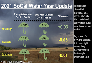
How do you like your rain? In small increments throughout winter or in big random deliveries? If you said 'big random deliveries', then have I got a winter I'd like to sell you. After 1" of rain in a normally dry October, we then get a historically dry November followed by 1" of rain this week. And if the models are correct, another inch next week. This weekend though looks sunny and cool, followed by a potential atmospheric river Tuesday through Thursday. So far most locations in Southern California have 2" of rain (which is 100% of normal- so we're on track) and another inch next week would be a good way to beat our drought. If anything changes between now and then, make sure to follow North County Surf on Twitter!

BEST BET:

Tomorrow with small but fun combo swell (if you don't mind a little sinus infection) or next Tuesday to Thursday between rain squalls. 

NEWS OF THE WEEK:


Last week's vicious tornadoes in the Midwest put a deadly exclamation point on the end of an extraordinary year for extreme weather in the United States. Earlier in 2021, Texas froze and Seattle roasted. Parts of California flooded, burned, then flooded again. A hurricane that slammed Louisiana was so waterlogged that its remnants inundated New York City. A blizzard hit Hawaii. The weather was wilder than usual this year, and the reasons vary, climate experts say. The Washington Post did an extensive dive into the unusual weather this year and here's their report:

Crazy cold snap? Giant hail? December tornadoes? Those happen now and then on a planet with natural variations in weather patterns. But evidence increasingly shows that historic heat waves, monster rain events and ultra-intense storms are exacerbated by the warmer air and water of our overheating planet. “The only two truisms when it comes to extremes in climate change are that almost everywhere: The hot hots are getting hotter and more frequent, and the wet wets are getting wetter and more frequent,” said Daniel Swain, a climate scientist at UCLA who specializes in the relationship between climate change and weather. The year began with what Swain might call a “wetter wet” against the backdrop of a year-long drought, and it just got weirder from there.

JANUARY
California floods amid drought

Swain said climate change has created conditions in which — even if the total amount of rain and snow is fairly stable from year to year — the West’s rainy season is shorter, and the moisture often falls in violent bursts rather than long, drought-squelching soaks. It’s like the difference between sipping a cup of water vs. having it thrown at your mouth. For five days late in late January, California had water thrown at its mouth. Much of the West’s water comes from atmospheric rivers, which are like fast-moving, airborne conveyor belts that shuttle moisture from the Pacific to the West Coast about a dozen times a year. They are notoriously unpredictable and are often described as giant fire hoses in the sky. This particular atmospheric river blasted as much as 16 inches of rain and 100-mph winds through the middle of the state. Mudslides and floodwater covered major highways. The Big Sur River overtopped its banks. Debris flowed unchecked through areas recently scarred by wildfires. Higher in the Sierra Nevadas, roads were buried beneath up to nine feet of snow.

FEBRUARY
Deadly cold in Texas


It was strolling-around-the-neighborhood weather in much of Texas for the first week of February. Then the next week, frigid Arctic air stretched drastically far south and obliterated low-temperature records from North Dakota to Mexico. At least 210 people died in Texas, where the underprepared power grid gave out and more than 4 million households lost power. Travel was nearly impossible, as many areas were covered in snow and ice. Crops were devastated as newly planted seedlings in the Rio Grande Valley couldn’t withstand the freeze. The Texas cold snap may have been an anomaly. But some scientists believe that the warming of the Arctic has disrupted the winds that encircle the pole, unleashing giant blobs of frigid air into lower latitudes.

MARCH, APRIL AND MAY
Supersized storms


In spring, violently rotating thunderstorms called supercells are common across the country as cold and warm air masses meet and dance around each other. But the three supercells that struck Alabama and Georgia in late March were notable for their power and endurance. All three spun out tornadoes and lasted several hours. One cell traveled more than 400 miles through four states. Just two days later, another powerful system swept from East Texas to North Carolina, leaving a trail of hail, flooding and tornado damage. A couple of weeks later, more than a foot of rain in one day dumped onto parts of Louisiana that were already saturated from an unusually rainy April. And though it was a light year for hail overall, three dramatic storms during two days in April flung ice chunks the size of baseballs and softballs through roofs and windows around Fort Worth, San Antonio, Oklahoma City and Norman, Okla. May and June are usually prime tornado months, and true to form, May began with a three-day bout of twister-spewing thunderstorms that dropped tornadoes from Colorado to Georgia. It’s nearly impossible to tie an individual storm to climate change, but the trends show a greater probability of violent storms in a warmer climate, said Victor Gensini, an atmospheric sciences professor at Northern Illinois University who studies tornadoes and other severe storms. Gensini compared the uncertainty to dice. If you change one side of a die from a five to a six, you will have a much greater chance of rolling a six. But when it happens, you can’t be sure if that die is showing the six you added or the one that was always there. Though hurricane season was still a couple of weeks away, Tropical Storm Ana became the first of 21 named Atlantic storms of 2021 and made this the seventh straight year that a named storm formed before the actual hurricane season, a trend scientists have linked to warming ocean waters. Ana didn’t make landfall as eight others would, but it kicked off the second year in row that the National Hurricane Center would use all the names on its list.

JUNE
Otherworldly heat


Beginning in mid-June, a blanket of unprecedented hot air spread over the typically mild Pacific Northwest, an event scientists say was “virtually impossible” without climate change. Locations in seven states set all-time heat records. Seattle hit 108 degrees, Portland 116, and Salem, Ore., recorded 117 on June 28, matching the hottest day ever recorded in Las Vegas. Hundreds of deaths were attributed to the heat. The culprit was an alarmingly strong heat dome, a sprawling mass of high pressure and hot air that muscles out any cooling systems that come near it. And its sheer power rattled experts who study heat waves all the time. “That just blew everyone’s minds,” said Swain. “It was just so far beyond what really anybody thought was physically possible in our present climate. … What happens if that happens over Chicago in July or Delhi during the dry pre-monsoon season? What does that look like? ... That’s very unsettling.”

JULY
Storm clouds of fire


On July 14, the largest, most destructive wildfire of the year began on the West Coast about 100 miles north of Sacramento. The monstrous Dixie Fire was exactly what fire experts had feared after the historically horrible 2020 wildfire season and the extreme June heat. It would become California’s second-largest fire ever, burning nearly 1 million acres in the Lassen National Forest and destroying the town of Greenville before it was finally doused in late October. Within days after it started in the Feather River Canyon, it produced pyrocumulonimbus clouds — literal storm clouds of smoke and fire — that rose more than 30,000 feet. Its smoke wafted all the way to New England.

AUGUST AND SEPTEMBER
Smoke and a string of hurricanes


As Dixie and other large fires across the West continued to belch smoke into the atmosphere, plenty of precipitation was on its way to the other side of the country. By mid-August, tropical storms and hurricanes had queued up in the Atlantic. Tropical Storm Fred was first in line of the August storms, rolling through the Florida Panhandle and causing deadly flooding in North Carolina. Then came three days during which Tropical Storm Henri made a rare Rhode Island landfall and drenched New England while unrelated storms caused catastrophic flooding in North Carolina and a freak deluge in Tennessee. That hyper-localized storm dropped about 21 inches of rain in one day over Waverly, Tenn., about an hour west of Nashville. Quick-rising water killed at least 22 people, including a woman who was live-streaming the flooding in her neighborhood At the very end of the month, the year’s biggest and most destructive storm rumbled into Louisiana Hurricane Ida hit Port Fourchon on Aug. 29 as a strong Category 4 storm with 150-mph winds so powerful that they reversed the flow of a portion of the Mississippi River for three hours. Ida knocked out power in New Orleans and Houma, submerged the town of Jean Lafitte and damaged or destroyed every structure in Grand Isle while covering it in three feet of sand. Ida’s wind diminished during its soggy trek north, but it still spun out tornadoes in New Jersey, Pennsylvania and Maryland. And it still had plenty of water. In a few hours beginning the night of Sept. 1, Ida’s remnants dumped up to 11 inches of rain over a swath that included densely populated areas of New York and New Jersey.More than three inches of rain fell in Central Park in just an hour, a record, engulfing subway tunnels. Thousands of homes and businesses were inundated, including some in places that rarely experienced high water. Fifty-two people drowned in the Northeast, including 11 who couldn’t escape from basement apartments in New York City. Altogether, Ida killed at least 91 people in nine states, according to the Centers for Disease Control and Prevention. On Sept. 14, the season’s last hurricane landfall occurred near Sargent Beach, Tex. Nicholas, a Category 1 storm, brought heavy rain but did relatively little damage as it meandered along the Gulf Coast. On Nov. 30, the sixth-straight above-average hurricane season officially ended. Hurricanes have always occurred, but models indicate that warmer temperatures combined with unchecked greenhouse emissions may make hurricanes wetter, stronger and more likely to veer toward North America.

OCTOBER
Historic rivers in the sky

In late October, three atmospheric rivers showed up on the California coast, and the last one was a whopper. Sacramento ended a record 212-day rainless streak on Oct. 18 and had its wettest-ever day on Oct. 24, when 5.44 inches of rain fell in 24 hours. San Francisco got four inches. By the time the water stopped, both cities had set new rainfall records for an October day. Along the way came the mudslides, rockslides, flooding and power outages that often accompany a deluge in a bone-dry place. In the Sierra Nevadas, snow again shut down highways. But there was very good news: All that precipitation doused remaining wildfires, including Dixie, and made a decent dent in the drought. Water in Lake Oroville, a major reservoir in northern California, rose 20 feet after falling so low in August that a large hydroelectric plant had to shut down.

NOVEMBER AND DECEMBER
Late-breaking tornadoes and a blizzard in Hawaii


Tornadoes occur year-round, whenever hot, moist air close to the ground collides with cooler, drier air above and creates thunderstorms. By late fall, the humid, unstable air needed for tornadoes is usually limited, especially outside the South. Not so this year. On Nov. 14, 11 twisters touched down in New York, Rhode Island and Connecticut; the four that landed in Connecticut were the only November tornadoes ever recorded in the state. The instability that produced them came from a strong cold front meeting Atlantic waters that were as much as six degrees warmer than normal. A few weeks later on Dec. 11, amid record-setting warmth, an even later, larger and more violent outbreak of tornadoes roared through nine states. The twisters sheared houses off their foundations, collapsed huge commercial buildings and tossed train cars through the air. More than 88 people were killed, making it the country’s deadliest December tornado outbreak ever. One extraordinary supercell produced a colossal tornado — or series of tornadoes — that chewed a 250-mile path of destruction from eastern Arkansas into Kentucky. It tossed debris more than 30,000 feet in the air; some items from damaged homes were reported found more than 100 miles away. Tornadoes were the big weather story, but not the only weather story, toward the end of the year. In mid-November some of the same areas of the Pacific Northwest that sweltered through heat and fires in summer and had been doused by rain in October were walloped by the most intense atmospheric river of the season. Flooding was extensive on both sides of the Canadian border. And in early December, a blizzard hit Hawaii. Snow isn’t unusual on the Big Island peaks of Mauna Loa and Mauna Kea, but an actual blizzard is, and that is what arrived in a stronger-than-usual Kona storm over the first weekend of the month. Post-storm images showed the mountain summits capped in snow. The lower elevations got more than a foot of rain. Honolulu had its wettest December day on record. While scientists say man-made warming isn’t the cause of most extreme weather events, they agree it is making many of them more frequent and intense. Heat waves are hotter, downpours are heavier, fires spread more quickly. Generally, more energy is available to storms, increasing atmospheric chaos and portending a turbulent future. “Every time we have one of these events, it’s like an at-bat,” Gensini said. “But we need to start looking at the batting average.”

PIC OF THE WEEK:


Xmas came early to whoever stumbled upon this little gem. 

Keep Surfing, 
Michael W. Glenn
Dominating
Santa Still Deciding If I've Been Naughty Or Nice
Launching A Website Called 'Surflie' Where The Forecast Is 6-8' & Offshore Everyday

Thursday, December 9, 2021

THE Surf Report

Well, Well, Well, Look What The Cat Dragged In...

SURF:


It's about time, wouldn't you agree? Looks like our flat spell (and sunny skies) are going away for the near future and bigger surf- and stormier conditions- will prevail. First up is the cold front rolling through So-Cal today. 


Lots of mixed up head high storm surf will peak tonight and drop steadily through tomorrow. 


There's also a small S building underneath- but that will be blown to bits from the storm tonight. Then we're back to waist high NW waves Saturday/Sunday (and a touch of small, fading S). And here's the tides, sun, and water temps for the next few days:
  • Sunrise and sunset:
    • 6:41 AM sunrise
    • 4:43 PM sunset
  • Water temps are holding in the low 60's
  • And tides have mellowed out since last weekend:
    • 4' at breakfast
    • 2' late morning
    • back up to 3.5' late afternoon

FORECAST:

The calm of the weekend should be replaced by a legitimate winter storm Monday afternoon through Tuesday. 


As it arrives, jumbled surf will build and we'll have well overhead messy conditions on Tuesday. Wednesday may be cleaner- with smaller NW surf- but the water will be DIRTY. 


By Friday though, we may see a smaller, cleaner NW swell in the chest high range- but I'm not sure on the water quality by then. 

WEATHER:


Oh boy, where do I start. How about 'When it rains it pours?' (Too easy). Maybe 'Feast or famine?' Or 'It's all or nothing'??? What I'm trying to say is, we had good rains in October, none in November, and now a big storm on the horizon. But let's talk about today though: A weak cold front is moving through our region this evening and we should end up with 1/4" of rain along the the coast. The weekend looks to be sunny and cool. And then... (drum roll please)... Southern California gets in on the Atmospheric River Party. After Nor Cal got hammered in October, then British Columbia last month, our part of the world is finally going to get drenched. Models are showing rain/wind starting later Monday into Tuesday. Early estimates should be at least 1" along the coast. After that, we should have clear cool conditions mid-week, then another weak storm may appear next weekend. If anything changes between now and then, make sure to follow North County Surf on Twitter!

BEST BET:

Tomorrow with leftover NW windswell or next weekend once the water isn't as polluted from Tuesday's storm...

NEWS OF THE WEEK:


If the warming Earth hasn't cause enough problems (heat waves, lack of snowfall, extreme storms, etc), now it's messing with our ocean currents. A recent story from the Washington Post shed light on the matter:


Earth’s ocean currents are known as the “global conveyor belt” — a planet-wide system that moves warm water north and cool water south. Now, the strongest current of all is speeding up — and humans are to blame. That’s the conclusion of a study in the journal Nature Climate Change that finds “robust acceleration” in the Antarctic Circumpolar Current (ACC).

The current, which circulates around Antarctica, is the planet’s strongest, and the only one that isn’t blocked by any land masses. The huge, circular current takes water clockwise around the globe, pushing more water than any other current and keeping Antarctica, which it encircles, cold.

Scientists used decades’ worth of data for the study, including satellite data on the height of the sea surface and information collected by Argo, an international fleet of robotic instruments that float all over the world’s oceans.

Though the current is mostly driven by wind, the researchers found that the acceleration is largely because of changes in the oceans’ heat. When the difference between temperatures between hot and cold waters increases, the currents that border them speed up.


That's what's happening to the ACC, and the researchers say human-caused global warming is to blame. The region absorbs much of the heat that human activity pumps into the atmosphere. As the planet continues to warm, the researchers expect the trent to continue. 

While scientists are still working to understand the consequences of accelerating currents, they believe the faster circulation will change the way heat is distributed in the world's oceans and affect marine life in areas that receive warmer waters. 

Earlier this year, researchers found that the current sped up in the past too- between 115,000 and 130,000 years ago during the last interglacial period. That acceleration may have caused everything from weather changes to a decline in the ocean's ability to absorb carbon dioxide. Their work was published in the journal Nature Communications.

BEST OF THE BLOG:


Wanted to say thanks to everyone that signed up for the North County Board Meeting's 5th annual holiday party next week. And if you haven't RSVP'd yet- we only have a couple spots left! If you'd like to see good friends, eat good food, and help a good cause, hit me up at northcountyboardmeeting@gmail.com by TOMORROW (Friday the 10th) to reserve your spot. Priority Public House has graciously opened their doors for us on Wednesday, December 15th at 5pm for appetizers, dinner, music, a live auction, and a bunch of surf talk. Presented by Venture LLP, part of the proceeds will help support local charities this holiday season. 

Tickets are $50 per person and appetizers and dinner are included. Make sure to dress warm as we'll be eating under their outdoor tent. And yes, we will have heaters for the night's festivities. Thanks again for your support and we'll see you on the15th!  

PIC OF THE WEEK:


What looks like more work- outracing these locomotives are trying to paddle out over that shallow reef?

Keep Surfing, 
Michael W. Glenn
Guide
Training To Be A Pro Wrestler
Got An Invite To The Eddie! (Anyone Have A 9'0" Rhino Chaser I Can Borrow)?