Friday, July 25, 2014

THE Surf Report


Are we there yet?

SURF:
Been a slow week of surf. Just a little bump of SW towards the beginning of the week but really only the OC had fun chest high waves. We got a little boost out of the NW yesterday but really only SD had fun chest high waves. Today we still have a little NW in the water for waist high+ waves around here and chest high sets in SD.
Tomorrow we get a little boost out of the S for waist high sets and maybe something slightly bigger towards the OC on Sunday. All in all it will be a small weekend of surf. At least the weather is nice and the water has rebounded to 70 finally.
Tides the next few days are about 0' at sunrise, up to 4.5' mid-morning, down to 2' mid-afternoon and up to 5.5' at sunset. Make sure to keep up to date on the waves/weather at Twitter/North County Surf.

FORECAST:
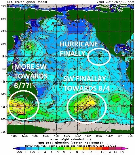
Models are finally showing some life in the tropics and Antarctica. So you're saying there's a chance... First up is some quiet surf to start the week.
We actually have a tropical storm out in the Pacific today- Genevieve- but she's only got 50 mph winds and halfway to Hawaii. Don't blame her. We'll get nothing from it unfortunately.
The NW windswell starts to build late Wednesday into the 2nd half of next week.
And charts are showing another hurricane forming (Hernan maybe?) which would give us a good S swell- even here in SD- towards the 2nd half of next week. It's still a LOOOOONG way off but I'm hoping we see some chest high waves here, shoulder high waves from it in far north county SD, and overhead waves in the OC. Just in time for the US Open.
And the southern hemisphere is getting it's act together. If the models hold, a storm should form early next week to give us good head high sets around the 5th of August. From famine to feast is what I say.

WEATHER:

Great weather today. At least for us weather nerds. We have a monsoonal wave moving through from the south and it's giving us 'tropical' weather conditions. Even some showers and a clap of thunder in our local hills. That should exit this afternoon and we'll be left with sunny skies and warm humid temperatures in the low 80's at the beaches. This weekend we may get a couple more shots of tropical clouds overhead but I think today may be the cloudiest day. Low clouds and fog will also be at a minimum the next few days. Early next week our high pressure shifts slightly and the tropical clouds decrease and we get more sun and seasonal temps in the high 70's. All in all some great late summer weather is on tap for the next week.

BEST BET:
A couple options- maybe that S hurricane/NW windswell combo the 2nd half of next week. Or a good SW swell the beginning of the week of the 4th. But until then, zilch.  

NEWS OF THE WEEK:

Turning saltwater into drinking water is all the rage right now. Well, at least with billion dollar corporations that can build a plant on the ocean like Poseidon in Carlsbad. But until more come on line to solve our water crisis, can't we just dip our cups into the ocean and have a swig? Well, seawater contains salt as you know. When humans drink seawater, their cells are taking in water and salt simeltaneously. But while humans can safely ingest small amounts of salt, the salt content in seawater is much higher than what can be processed by the human body. Additionally, when we consume salt as part of our daily diets, we also drink liquids, which help to dilute the salt and keep it at a healthy level. Living cells do depend on sodium chloride (salt) to maintain the body’s chemical balances and reactions; however, too much sodium can be deadly. Human kidneys can only make urine that is less salty than salt water. Therefore, to get rid of all the excess salt taken in by drinking seawater, you have to urinate more water than you drank. So it's catch 22 drinking saltwater; eventually you die of dehydration even as you become thirstier. So the next time you're in that marathon session at Lowers and you're dying for a drink, it's probably best to not take a mouthful of seawater and wait for that 32 ouncer of Coke at Carl's Jr. instead.

BEST OF THE BLOG:

It's one thing Encinitas is not short on- Mexican food joints. Oh- and yoga studios. And crowded line ups. Anyway, one void that's being filled is seafood restaurants. From Happy Fish to Pacific Coast Grill to Lobster West to Fish 101, they've spouted up a like a breaching whale the past couple years. Hopefully none of these establishments serve whale, but regardless, it's the new trend in town. And opening soon is the Fish Shop at the former St. Germain's location- a couple blocks north of Swami's (and one block north of Union for all you cougars out there). Check out the full story in the North County Surf blog. As well as a mid-week Surf Check and a more in-depth THE Surf Report. All of that and more in the blog below!  

PIC OF THE WEEK:

It's been so long since I've seen good waves that I forgot what they look like. Then I saw today's Pic of the Week. And I don't think I've ever seen a wave that good in real life. So I'm back to square one.

Keep Surfing,

Michael W. Glenn
Famous
Going to Comic Con As The Invisible Man
On Small Days I Boogie Board So It's Always Overhead

Thursday, July 24, 2014

North County New Business News: Somthing Fishy Is Going On...

Besides the surf, greenhouses, and world yoga headquarters, Encinitas is known as the Mexican food capitol of the world. More than Mexico City. No, seriously, look it up. We've got little hideaways like Haggo's to high end Casa de Bandini. From basic Taco Bell to authentic La Especial Norte. From old school Juanita's to, well, old school Las Olas, there's at least 25 joints in town.
So if you're a restaurateur, let's just say the Mexican food market is pretty much covered. So what's the niche that's been popping up lately? Seafood. And with Encinitas being on the ocean, it's a no brainer. From little mom and pop shops like Lobster West to the fancy Pacific Coast Grill. From Josh Kerr's favorite Fish 101 to my grom's favorite Happy Fish, seafood diners are popping up like periscopes (bad pun, sorry). The latest to grace our shores is the Fish Shop on the corner of Highway 101 and I Street.
In the old St. Germain's location, the Fish Shop is the brainchild of Eric Leitstein, owner of the Union Kitchen and Tap, Encinitas Ale House, and a couple more restaurants in PB- like the PB Ale House and another Fish Shop. So far Eric's been on the right track and his recent locations have been busy with good layouts and décor. The Fish Shop's main draw besides the food will be the corner patio which should get a lot of use this summer.  The sign out front says a July opening but I think it will be more towards mid-August by the looks of their progress. Regardless, make sure to stop by in the near future and try it out.
In regards to the greenhouses in Encinitas, we hardly knew ye. From the old Encinitas Ranch fields, to the Hall property now Encinitas Community Park, to the Ecke property on Saxony that Shea homes is taking years to finish, to the 2 new developments east of the 5 in Leucadia, the old flower fields are dropping like flies. And who's the latest to bite the dust? The old grower east of the 5 freeway across from the new Encinitas Community Park in Cardiff.
Looks like 8 homes are being built on MacKinnon Ave., a couple blocks south of San Dieguito Academy. Like the rest of any new development in Encinitas, it's not a big one like Encinitas Ranch or nearby La Costa Valley, because there's no space left; only old greenhouses that are sitting on goldmines They're still a ways away to breaking ground; gotta do that environmental impact report, post the 'New Homes' sign, build the model, etc thing. I don't expect it to be move in ready until late next year.
Bummer to see this old greenhouse go. It was tucked away in a group of old school homes and every December they'd open up their lot and sell some Xmas trees. Cool local vibe. Make sure to check back on the North County Surf blog for updates.


Tuesday, July 22, 2014

Surf Check


Been kind of a downer lately. Our water temps have dropped the past couple of weeks and no real surf to speak of.
We had a little bump out of the SW and NW yesterday for waist high+ waves around here and the odd chest high+ set in the OC. Today both swells have backed off slightly for waist high sets in north county SD and the odd chest high set in the OC. Water temps have rebounded slightly to 68 and the wind started blowing early this morning out of the W.
Tides the next few days are 2' at sunrise, up to 4' mid-morning, down to 2' mid-afternoon, and up to 6' at sunset.

So is there any hope in sight? Not really unfortunately. The W winds blowing today will increase tomorrow and send some waist high NW windswell our way for Thursday into Friday.
And a few days ago there was a small storm off Antarctica that will give us waist high+ SW swell Friday into Saturday.
The tropics are starting to become active again with some waves of clouds coming off Central America- but no hurricanes to speak of yet.
After that it's looking pretty bad for next week. No storms on the charts from the northern or southern hemispheres. Best case is to get the hurricanes to kick into gear this weekend so we can get some surf early next week!


Thursday, July 17, 2014

THE Surf Report- Early Edition


Average is good.

SURF:
Nothing spectacular this week but plenty fun.
New SW filled in yesterday and peaked today with shoulder high sets here and head high+ waves in the OC. Water is still 70 degrees- plus or minus- and the clouds earlier this week have finally given way to sunshine. Tomorrow we have dropping SW swell for chest high sets- with shoulder high waves in the OC- water temps still floating at 70, and the sun should come out mid-day. It's pretty much a repeat on Saturday with the surf dropping a foot. Sunday is even smaller in the waist high range.
Tides the next few days are about 1' early, up to 5.5' mid-afternoon, and down to 2' at sunset. Make sure to keep up to date on the waves/weather at Twitter/North County Surf.

FORECAST:

Nothing impressive on the charts but we did have a little storm in the southern hemisphere pull together a couple days ago and we should get some chest high sets late Sunday into Monday. The OC should have consistent chest high sets but that's about it.
Further out, chest high sets from NW windswell is poised to build again towards Thursday in SD. But mid-week... nothing. The tropics are eerily silent and best case would be to see a storm form the middle of next week but even then we wouldn't get surf until next weekend. In a nutshell, nothing of significance is headed our way for next week.

WEATHER:

The weather is in limbo this weekend. Low clouds should break up by lunch and we've got a little tropical wave moving through tomorrow and Saturday. After that it's back to low clouds in the night and mornings. Models then show high pressure building over the 4 corner states the middle of next week and we'll get a little heat wave with temps in the deserts around 115 and the mid-80's here. Just need some surf to make it a combo!

BEST BET:
Tough call- dying surf tomorrow or a little bump in the SW on Monday. Not too thrilled with either. 

NEWS OF THE WEEK:

If you saw last week’s THE Surf Report, you may remember the story about the anchovies migrating into La Jolla, possibly due to the warm water from El Nino. Seems to happen every 15 or so years when we have the larger than normal El Ninos- we get unique fish to our area. But what will happen if global warming keeps on pace and our ocean warms to unseen levels? Well, the migration of tropical fish as a result of ocean warming will pose a serious threat to the temperate areas they invade, because they like to overgraze on kelp forests and seagrass a new study concludes. And who just happens to have a TON of kelp and seagrass? North County San Diego of course. The harmful impact of tropical fish is most evident in southern Japanese waters and the eastern Mediterranean, where there have been dramatic declines in kelps. There is also emerging evidence in Australia and the US that the spread of tropical fish towards the poles is causing damage in the areas they enter. "The tropicalisation of temperate marine areas is a new phenomenon of global significance that has arisen because of climate change," says study lead author, Dr Adriana Verges, of UNSW Australia. "Increases in the number of plant-eating tropical fish can profoundly alter ecosystems and lead to barren reefs, affecting the biodiversity of these regions, with significant economic and management impacts." And in our case- more blown out days in the surf if the kelp is missing. The study is published in the journal Proceedings of the Royal Society B. As the oceans have warmed and the climate has changed, hotspots are developing in regions where the currents that transport warm tropical waters towards the poles are strengthening. Increased flow of the East Australian Current, for example, has meant waters south-east of the continent are warming at two to three times the global average. Tropical fish are now common in Sydney Harbor during the summer months. Japan, the east coast of the US, northern Brazil and south eastern Africa are also strongly influenced by coastal currents that transport warm tropical waters. "In tropical regions, a wide diversity of plant-eating fish perform the vital role of keeping reefs free of large seaweeds, allowing corals to flourish. But when they intrude into temperate waters they pose a significant threat to these habitats. They can directly overgraze algal forests as well as prevent the recovery of algae that have been damaged for other reasons," says Dr Verges. Tropical fish expanding their ranges into temperate areas include unicornfish, parrotfish, and rabbitfish. The study authors include researchers from Australia, the US, Spain, Singapore, the UK and Japan. So far we’ve seen:

Southern Japan:
More than 40% of the kelp and algal beds have disappeared since the 1990s, a phenomenon known in Japan as isoyake. Tropical species including rabbitfish and parrotfish appear to be mainly responsible. Although these fish have been present for a long time, their annual grazing rates have increased dramatically as ocean temperatures in winter have risen. Corals now dominate the ecosystem in many locations. The changes have led to the collapse of the abalone fishery.

Eastern Mediterranean:
Tropical fish moved into the eastern Mediterranean from the Red Sea after the opening of the Suez Canal. In recent decades, rabbitfish numbers have increased, resulting in hundreds of kilometres of deforested areas and a 40% decrease in the variety of marine species. As the Mediterranean warms, the rabbitfish are expanding their range westward, putting other shallow ecosystems at risk.

US:
There has been a more than 20-fold increase in the number of parrotfish in the Gulf of Mexico -- a species which consumes seagrass at five times the rate of native grazers. The number of plant-eating green turtles and manatees has also increased.

Australia:
In Western Australia, emerging evidence suggests that increases in the number of tropical fish are preventing the recovery of kelp forest damaged by a heat wave in 2011. In eastern Australia, kelp has disappeared from numerous reefs in the past 5 years and Dr Verges' research suggests intense grazing by tropical fish on the kelp preceded this.

PIC OF THE WEEK:

You know what's great about Canada? Besides Keanu Reeves, Pamela Anderson, Celine Dion, and Bryan Adams? Actually, nothing is great about that group. But besides them, the surf is the real star. The west coast has all kinds of nooks and crannies with amazing waves just waiting to be discovered. If you don't mind dodging Orcas in the line-up and bears on the beach. The east coast on the other hand has point after point after point that will zap your legs of energy after one 1/4 mile wave. Not in the winter time though as there's snow on the beach, 40 degree water temps, and hurricane force winds blowing from the arctic circle. On 2nd thought, Canada isn't that great. The Pic of the Week is just a mirage.

Keep Surfing,

Michael W. Glenn
Ringleader
So Fresh, So Clean
Building a 2.5 Mile Chicama Wavepool Replica With Kickstarter

Tuesday, July 15, 2014

Surf Check


Not much going on out there unfortunately. June Gloom has finally arrived, our water has dropped from 75 down to 70 (with a couple colder spots unfortunately), and the surf is downright small.
Most spots are knee high with waist high sets from the NW/SW. We also have some pretty low tides in the morning and along with the slight S wind and overcast conditions, the small swells are looking pretty unappealing.
Tides the next few days are -0.5' at dawn, up to 5.5' in the afternoons, and down to 1' at sunset. Water temps have also dropped slightly due to a variety of factors and are hovering around the high 60's/low 70's.
As far as our weather goes, June Gloom has finally arrived. I thought we might be past the worst of it when it didn't arrive in May, June, and early July, but I was fooled. Looks like the low clouds may hang around at the beaches all week. High pressure is forecasted though to return early next week with more sun and warmer temps towards Monday.
So if you don't mind a little gloomy weather, then you'll love the upcoming surf this week. We had a fairly large storm a few days ago- not strong but broad- and we'll get some head high sets from it tomorrow afternoon into Friday. The OC will get overhead lines. No NW windswell to break up the swell, so beachbreaks will be walled.
On it's heels is a smaller storm that will send out a SSW swell late Sunday and peak Monday. Look for chest high waves here with shoulder high sets in the OC.
And further out, models show a little storm trying to organize but it's right on the edge of our swell window. Hopefully we'd get a small S swell from it towards 7/25.
The north Pacific is fairly dormant and the tropics are on standby oddly enough- even though we're moving into high gear for hurricane season. But that all could change in the matter of a few days down there. So get the good SW swell this week while you can!


Friday, July 11, 2014

THE Surf Report- Late Edition


Chillaxin'

SURF:
4th of July weekend couldn't have been better- solid S swell, warm water, and tropical clouds overhead. That's what makes this country great!
The S lasted longer than expected too with the OC seeing fun waves until mid-week. Today is pretty much flat with mostly sunny skies and wind out of the WSW at 10. At least the water is still hovering around the mid-70's. Luckily for us the nice weather will stick around this weekend, the warm water temps will hold, and we've got a little combo swell filling in this weekend.
First up is a small storm in Antarctica that is sending us fun chest high sets from the SW late Saturday. Look for it to peak on Sunday.
We also have NW winds blowing in the outer waters today that will give us waist high NW windswell on Sunday. The result is small surf tomorrow but fun waist-chest high combo surf on Sunday.
Tides the next few days are 0' at sunrise, up to 4.5' at 10:30am, down to 1' at 4pm, and back up to 4' at sunset. Make sure to keep up to date on the waves/weather at Twitter/North County Surf.

FORECAST:
The fun little combo swell rolls into Monday and starts to fade by Tuesday.
On it's heels though is more SW swell from a good storm in the southern hemisphere. Look for chest high sets by Tuesday afternoon and shoulder high sets in far north SD county on Wednesday. The OC sees head high+ waves.
Models have another small storm reorganizing in the wake of the Wednesday swell and we should get more chest high SW surf towards next Sunday (and head high in the OC). No NW on the charts unfortunately to break up the SW lines but all in all some waves the 2nd half of next week.

WEATHER:

The warm water temps are influencing a couple things lately- the 'June Gloom' is having a hard time sticking around and the low temps at night are almost 70 degrees since the warm air coming off the ocean makes it feel tropical around here. High pressure will strengthen slightly this weekend with tropical clouds probably arriving late Sunday or Monday. The low clouds in the night/mornings will also break up a little bit earlier too- so instead of waiting until mid-morning for the sun at the beach, you may see it around 7am by Monday. Good conditions will last at least until mid-week.

BEST BET:
Sunday will have a fun little combo swell but Wednesday's southern hemi looks to be a little bigger. Regardless, the water's warm and the sun's out.

NEWS OF THE WEEK:
All the talk of El Nino is usually centered around the winter months and rightfully so. That's when the biggest surf and most destruction occurs; usually from beach erosion, flooding, or mudslides. But we can't overlook the great start we've had this summer with the building weather phenomenon. We’ve already had the strongest hurricane on record for May (Amanda), the quickest intensification of a hurricane on record (Cristina went from a tropical storm to a category 4 in about 24 hours), and it's the first time we’ve had two category 4 hurricanes before the month of July even started. Our water temps are also ridiculously warm- and that's been the case since early June. Currently most beaches are between 73-75 degrees from L.A. to the Mexican border. The average this time of year is around 67-69, so you can see we're already 5 degrees warmer than usual. And the warmest water temps normally peak around early to mid-August, so we should have 4 more weeks of the ocean warming up for us. And with the warmer than usual water, the fish have been a bit confused. Did you see the millions of anchovies this week off Scripps Pier in La Jolla? If not, have a look...

Amazing. Best part is around the 34 second mark; you can see the anchovies spreading in a circle to move away from a leopard shark. So with all the warm water, how come we haven't gotten much hurricane surf this summer? Well, summer just technically started 3 weeks ago, so the water temps haven't peaked yet as mentioned above.
There's also a pool of cool water (relatively speaking to hurricane development) off Baja, so when a storm forms off mainland Mexico and moves into our swell window, it starts to die. So when will that pool of cold water start to warm up? Hopefully soon.
The real bulk of the hurricanes happen mid-July to mid-September so we haven't even hit the meat of it yet.
Also, worldwide, hurricane activity peaks in early September. So we still have a shot of getting solid hurricane surf in the next couple of months here. So hang in there! Things will only get better. And we're not even talking about the El Nino this winter!

PIC OF THE WEEK:

Since the Chargers aren't back in action yet, the Padres stink as usual, hoops are hibernating, US soccer is out of the World Cup, and the surf is flat today, then there's no excuse not to watch the J-Bay contest at aspworldtour.com. Arguably the world's best right hand point, this place begs for on the rail surfing. So enjoy the Pic of the Week and reminisce what Rincon was like back in the early 1900's.

Keep Surfing,

Michael W. Glenn
Fabled
Now The 2nd Most Popular Person In Cleveland
Been Holding My Bottom Turn For 3 Hours Now