Thursday, November 30, 2023

THE Surf Report


No Complaints.

SURF:


If you're a surfer in California, things are looking pretty sweet right now. Lots of surf, great weather, plenty of spots lighting up- it doesn't get much better than this. And hopefully you saw some of those photos coming out of Northern California last weekend- wowza. Tired yet? Still got gas in the tank? Good- there's more coming. 


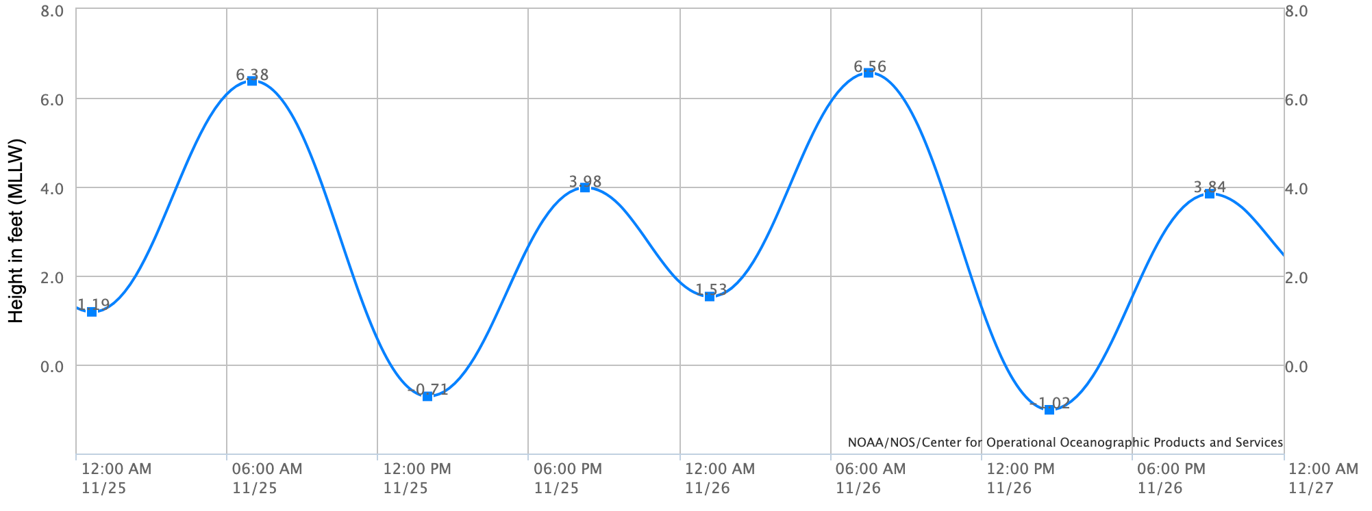
First up, a storm generated some short period NW swell and is filling in this evening. For Friday, look for shoulder high surf that drops quickly into Saturday. By Sunday we're back to nice weather and waist high+ surf. And here are the tides, sun, and water temps for this weekend:
  • Sunrise and sunset:
    • 6:42 AM sunrise
    • 4:44 PM sunset
  • Water temps are 63 +/-

  • Tides are back to normal this weekend:
    • 3' at sunrise
    • up to 4.5' at lunch
    • and down to 1' at sunset
FORECAST:


The week starts out small but still rideable with a new small NW for chest high sets. Mid week looks small too but clean- and then we have more swell moving in towards Wednesday. 


Charts show a good storm above Hawaii sending more WNW for shoulder high+ surf into Friday. The Aleutians take a breather after that but the N Pacific looks to be active into December so we may have more surf by mid-month. If anything changes between now and then, make sure to follow North County Surf on X.

WEATHER:


The showers have moved through today (about 1/4" along the coast) and we have good weather until at least mid-week. After that, models diverge but showers MAY return next weekend. Until then, here's what we have on tap:
  • Friday and Saturday: Sunny and cool. Temps 65/48
  • Sunday through Wednesday: Slightly warmer and temps 70/55.
  • Late next week: A return of showers?
BEST BET:
  • Friday with shorter period WNW and clean condtiions
  • Wednesday with better WNW

NEWS OF THE WEEK:


Now that El Nino is charging full steam ahead, what should we expect once winter kicks in towards January? The National Oceanic and Atmospheric Administration (NOAA) can shed some light on the subject for us:

After the last three winters of La Niña conditions (weren’t we all ready for a change!), the tropical Pacific is looking much different this year, with a strong El Niño likely this winter. Historically, how has El Niño shaped precipitation (rainfall + snowfall) over the U.S.? Let’s dig in and find out.

What happened during December-February for previous strong El Niños?

For the 7 strongest El Niño events since 1950, wetter-than-normal conditions occurred along the West Coast and southern tier of the U.S., especially in the Southeast. This is expected because El Niño causes the jet stream to shift southward and extend eastward over the southern U.S. However, there are clearly some differences among the events if you look at the details in the maps. For instance, the 2015-16 and 1957-58 strong El Niños were not as wet as expected over the southern U.S. and were even dry in some locations. What is the story there?

The devil is in the details.

When forecasters put together a prediction, one consideration is the forecasts generated by climate models, such as from the North American Multi-Model Ensemble (NMME). You might think that the NMME produces a single forecast map for the upcoming winter, but nope! Each month, the NMME produces hundreds of forecast maps from several different models. Why so many maps? Well, the short version of the story is that the chaos of weather can have big consequences for our seasonal predictions. We cannot possibly say what the weather will be like on January 1st based on model forecasts that were made in early November. So, by running models many times, we are simulating a lot of different possible “weather outcomes” that can occur over a season. 

The easiest way to examine these model predictions is not by staring at hundreds of maps (trust me, we’ve tried), but rather by examining the average of all the maps (this is called an “ensemble mean”). The average isolates the seasonal forecast signal (like El Niño) while removing the noise of chaotic weather. The forecast averages are expecting a strong El Niño this winter; not surprisingly, bears a striking resemblance to the expected winter El Niño precipitation pattern.

However, this is a bit misleading because, as just noted, there are actually hundreds of forecasts, and this is just an average of all of them. We know, because of chaotic weather, that the upcoming reality could more closely mimic any of the hundreds of individual forecasts. And these forecasts can differ considerably from each other. 


For example, one forecast that looks quite similar to the NMME average. On the other hand, another has taken from the same model from the same starting month with basically the same El Niño, has almost the opposite pattern! And we cannot rule out either outcome actually happening for the upcoming winter! 

This, in a nutshell, is the curse of internal variability. Basically, a single model, run forward with slightly different initial states, can lead to very different forecasted outcomes for the upcoming El Niño winter. 

So, what’s the point of a making winter predictions?

If I’m basically saying that anything can happen this winter, then why do we bother to produce seasonal predictions? Well, as we have emphasized on the blog, although almost anything can happen in a given winter, El Niño or La Niña can tilt the odds in favor of a particular outcome, meaning that those hundreds of predictions may lean in a certain direction. Additionally, the stronger the El Niño, the more likely the U.S. winter precipitation pattern will match both the average of the computer model forecasts and the typical El Niño precipitation pattern. Because there are higher chances in certain outcomes (e.g., a wetter winter), the presence of El Niño can help users assess risk and make plans. 

Not convinced yet? We can put my claim to the test by assessing how well the typical or expected El Niño winter precipitation pattern matched up with what actually occurred for past winters. We can do that by examining all previous U.S. precipitation forecasts produced by the NMME, the hundreds of individual forecasts and the multi-model average, for all past winters from 1983-2022. The schematic above breaks down these evaluations.

I have taken every winter precipitation pattern from this period and calculated how well that pattern matched the individual NMME forecasts for that winter, the NMME average forecast, and the expected El Niño precipitation pattern. The values in this evaluation range from -1 to +1, with values closer to +1 indicating a good match with the actual observed pattern, values near 0 indicating no match, and negative values closer to -1 indicating an inverse match (“mirror image”). All these calculations for all 40 winters are presented in a single plot and arranged from left to right according to the strength of the La Niña (strongest farthest left) or El Niño (strongest farthest right), as shown in the bottom left of the schematic.

There’s a lot to take in from these comparisons, but there are three main takeaways:


The first in this sequence reveals two of the main takeaways.

The stronger the El Niño or La Niña, the more likely that the actual winter pattern will match the average model forecast pattern. This is why seasonal predictions work, and why we care so much about ENSO! The tendency is for the average model forecast to perform better at stronger Niño-3.4 index values. In fact, by this metric, the forecasts have performed quite well for most (but not all! – more on that below) moderate-to-strong El Ninos.

For a given winter forecast, chaotic weather causes a wide range of performance among individual model forecasts. This second takeaway, which causes the most wailing and gnashing of teeth among forecasters and their users, is the performance from individual model forecasts. In fact, for a given winter, there are usually some forecasts that perform quite well and some that perform quite poorly, even though there are no major differences in the models’ ENSO forecast between the high- and low-performing forecasts. Instead, the main difference is what we saw in those two forecast maps above: unpredictable, chaotic weather. Unfortunately, it’s likely impossible to distinguish those high- and low-performing model forecasts well in advance. Again, that’s the curse of internal variability.

In the second step of this sequence, we now look at how well the observed precipitation pattern matched the expected El Niño or La Niña precipitation pattern.


This addition reveals the third takeaway.

The average model forecast closely resembles the “expected” El Niño/La Niña precipitation pattern for most winters. This point comes out when we consider the average model forecasts, that represent the El Niño or La Niña precipitation patterns for a given Niño-3.4 index value. This is the models’ way of agreeing with what we’ve been claiming at the ENSO Blog for years: ENSO is the major player for predictable seasonal climate patterns over the U.S. If there were another more important source of predictability, we would expect a bigger separation between those colored diamonds and the dark grey dots.

The comparison between the two biggest previous El Niños in this record, the winter of 1997/98 (a forecast success) and 2015/16 (widely regarded as a forecast “bust,” or how forecasters generally describe a bad forecast), are a great illustration of this final point. but the upshot is that the influence of chaotic weather variability could have reduced the 1997/98 forecast performance much more than it did, and it likely was a factor in why the 2015/16 forecast performed so much worse.

Finally, let’s put these comparisons in the context of the forecast for the upcoming winter.

The likelihood of a strong El Niño increases the chance that the precipitation pattern for the upcoming winter will match both the NMME average and the expected El Niño pattern reasonably well, but, as I have been emphasizing, we cannot rule out the possibility that reality will have other plans.

That’s awfully convenient!

At this point, you might be saying, “Hold on, you’re telling me that ENSO is the main driver of the winter precipitation outlook, and if it busts, we can just blame it on the noise of chaotic, unpredictable weather? That sounds like a cop-out (and a little suspicious coming from a writer for the ENSO Blog).” That’s a fair question! As scientists, we need to continuously reevaluate our assumptions, check for blind spots, and tirelessly strive to improve our understanding of our forecast models. I can assure you that these efforts are being made, especially when the seasonal conditions deviate from expectations, and hopefully they will lead to better seasonal predictions with higher probabilities.

The main point I’m trying to make, however, is that when a forecast busts, it isn’t necessarily because there is a clear reason, a model bug, or a misunderstanding of the drivers. It could just be because there is a certain amount of unpredictable chaotic weather that we cannot predict in advance. That means that we must remember that seasonal outlooks are always expressed as probabilities (no guarantees!) and that we need to play the long game when evaluating seasonal outlooks – a single success or bust is not nearly enough.

BEST OF THE BLOG:


Want to give a big THANK YOU to everyone that RSVP'd to this Friday's Hollowday Party, benefiting the Maui Strong Fund!

This year's charity event, presented by our friends at Venture LLP, will be at Master's Kitchen & Cocktail in culinary hotspot Oceanside, CA. An industrial space with classic history, Masters was once a well remembered drag car shop. The revamped restaurant kept its authentic character, and is the perfect spot to get you in the holiday spirit. And with this year's fundraiser, we'll be benefiting our fellow Hawaiian surfers through the Maui Strong Fund, supporting the rebuilding of historic Lahaina town. And it couldn't be possible without YOU and our auction sponsors:
  • Electra Bicycles
  • Surfhouse and Coffee Coffee
  • Solterra wine from payrollHUB
  • Mark K. Ley fine art
  • The Cottage Restaurant
  • Canvas print from the North County Board Meeting
  • Whit Aadland from Whit's Musician Devolpment
  • Captain Fin Co. x Thomas Campbell x Type G
  • Caves Wine Shop
  • Lightning Bolt Surfboards
  • and Alila Marea Resort
And just a reminder that dinner, drinks, live music, and auction gets started at 5:30 PM. Thanks again for the support and we'll see you then! 

PIC OF THE WEEK:


A lone surfer in south county SD having the time of his life. We should all be so lucky. Oh- I guess we have been lately. Never mind.

Keep Surfing, 
Michael W. Glenn
Much Obliged
I Like To (Christmas) Party
Have Logged 3.8 Years Of Accumulated Tube Time To Date

Thursday, November 23, 2023

THE Surf Report


Almost Time To Feast.

SURF:


The little surf we had this week was met with suspect conditions today- but we're all at Grandma's house so it doesn't matter. For the remainder of the holiday weekend though, things are looking up- with a slight fly in the ointment tomorrow. 


Look for new chest high WNW to fill in this evening and bumpy conditions on Friday from a passing weak cold front. Surf drops slightly Saturday then picks back up to chest high+ from the WNW on Sunday. Weather should be good by then too. And here are the tides, sun, and water temps for this weekend:
  • Sunrise and sunset:
    • 6:28 AM sunrise
    • 4:43 PM sunset
  • Water temps are 63 +/-

  • Tides are pretty wild this weekend with a 7'+ swing:
    • 6.5' at sunrise
    • down to -1' at 2 PM
    • and back up to 3' at sunset
FORECAST:

Not much to going on next week except leftover small but fun WNW on Monday. 


Models though show the N Pacific coming to life late in the week and we could be back to waves and rainy weather by Sunday. If anything changes between now and then, make sure to follow North County Surf on X (Twitter).

WEATHER:


Weak cold front is making it's presence felt today and will peak tomorrow with a small chance of showers. After that, high pressure sets up and it's back to sunny skies and Santa Anas. Here's what we have on tap:
  • Friday: Slight chance of showers. Temps 63/54.
  • Saturday to Saturday: Potential Santa Ana conditions early in the work week. Sunny and 68/48.
  • Next Sunday into early December: Rain finally?
BEST BET:
  • Sunday with new WNW and nice conditions. 
  • Maybe next Sunday with new WNW but the return of rain?

NEWS OF THE WEEK:


When you're sitting in the living room this evening, all sleepy from the turkey, and you don't want to talk anymore politics with your crazy uncle, hit him with...

THIS DAY IN WEATHER HISTORY!

1999: Santa Ana winds gusting to 75 mph surfaced in Orange County and the Inland Empire. A falling tree crushed a car in Lake Forest and two large tents covering Christmas Trees were destroyed in Laguna Niguel and Mission Viejo. A swarm of tumble weeds was reported along Interstate 15.

1987: Dense fog with visibility reported at times less than 10 feet occurred in the Inland Empire. A number of multi-vehicle crashes occurred on I-215 between Temecula and Sun City involving 42 vehicles. One was killed and 19 were injured. 1986: Strong Santa Ana winds hit LA and the mountain foothills. Gusts to 54 mph
were recorded (unknown location), but estimated gusts were 70 mph. Only 30-40 mph gusts were estimated at Mt. Laguna. An unfinished house in Glendale was blown to bits. Numerous beach rescues were needed for sailors and windsurfers. Two sailboat masts were snapped in a boat race at Channel Islands.

1965: Heavy storms drawing tropical moisture in the mountains and desert started on 11/22 and ended on 11/25. Storm totals: 20 inches at Mt. San Gorgonio, 16 inches at Mt. San Jacinto, six to nine inches at Banning-Cabazon, over four inches at Palm Springs, less than one inch near the Salton Sea. The one-day total was over nine inches at Snow Creek. 15 died all over Southern California. The entire region was hit hard with severe flooding, including road and bridge washouts and debris flows. Santee was inundated. Two drowned attempting to cross the Whitewater River. Five died in Tijuana. One died in Rancho Cucamonga, another drowned in San Bernardino and three drowned in Lytle Creek flooding. Record flood levels on Tahquitz Creek. Spring Valley Creek floods in southeast San Diego. The Sweetwater River floods parts of National City and Chula Vista. Record flood levels were recorded at Tahquitz Creek. It was the largest flood on the Whitewater River since 1938. On this day 9.60 inches fell in Cuyamaca, 8.87 inches fell in Palomar Mountain, 6.54 inches fell in Big Bear Lake, 4.26 inches fell in Campo,3.11 inches fell in Elsinore, 3.09 inches fell in Alpine, 2.75 inches fell in Palm Springs, and 1.69 inches fell in Borrego Springs, each the greatest daily amount on record for November. For Palomar Mountain it was the second greatest daily amount on the entire record.

BEST OF THE BLOG:


LAST CALL THIS WEEKEND FOR HOLLOWDAY PARTY TICKETS! If you haven't gotten your 2023 North County Board Meeting Hollowday Party tickets yet, NOW IS THE TIME. We have a few spots left before we close registration on Monday. This year's charity event, presented by our friends at Venture LLP, will be at Master's Kitchen & Cocktail in culinary hotspot Oceanside, CA. An industrial space with classic history, Masters was once a well remembered drag car shop. The revamped restaurant kept its authentic character, and is the perfect spot to get you in the holiday spirit. And with this year's fundraiser, we'll be benefiting our fellow Hawaiian surfers through the Maui Strong Fund, supporting the rebuilding of historic Lahaina town. So come join us next Friday, December 1st for a night of dinner, entertainment, drinks, and pick up some holiday gifts during our legendary live auction. Tickets are just $100 per person- and we're almost full- so get your tickets NOW by emailing northcountyboardmeeting@gmail.com.

AND... we're always looking for auction items- big or small- to help support this cause. Please email if you can help. 

PIC OF THE WEEK:


I am thankful there are still empty waves in this world. Happy Thanksgiving everyone! 

Keep Surfing, 
Michael W. Glenn
Thankful
Only Eat Food That Is Tryptophan-Free
How Can I Do Airs Like An Eagle When I Surf With All These Turkeys?

Thursday, November 16, 2023

THE Surf Report


Hodgepodge.

SURF:


Great surf this week- especially in SD- and some Santa Ana conditions to boot. That has been replaced by a low pressure system today- the one with the big question mark last week- and we've got a hodgepodge of swells because of it. For Friday and Saturday, look for background SW groundswell and a continuation of W wind/groundswell for chest high+ sets. Saturday may be dicey though as the low pressure finally comes ashore with showers and more wind. 


Sunday cleans up with new shoulder high W wind/groundswell. And here are the tides, sun, and water temps for this weekend:
  • Sunrise and sunset:
    • 6:22 AM sunrise
    • 4:46 AM sunset
  • Water temps are in the low 60's due to the offshore winds this past week.
  • Tides are starting to mellow out this weekend:
    • about 3' at sunrise
    • up to 5' at lunch
    • and down to 2' at sunset
FORECAST:

High pressure is in control next week which will give us great conditions for our upcoming swells. 


First is a late season SW again for chest high surf towards N County SD and the OC by Tuesday. 


After that, more shoulder high WNW swell is headed our way for Black Friday with more clean conditions. 


And models show more shoulder high WNW late next weekend- with no rain in sight. If anything changes between now and then, make sure to follow North County Surf on Twitter.

WEATHER:


Not a bad rain maker yesterday with up to 2" in the mountains and about 1" along the SD/OC coast. We have another shot of rain late Friday into Saturday- but with smaller amounts- most likely 0.25". After that high pressure sets up with Santa Ana Conditions next week. Here's what we have on tap:
  • Friday-Saturday: Cloudy late Friday and showers Saturday. Temps 65/60.
  • Sunday: Mostly sunny and cool. Temps 63/56.
  • Monday and beyond: Potential Santa Ana conditions. Sunny and 70/55.

BEST BET:
  • Friday with combo swell and clean conditions.
  • Tuesday with small but fun SW and Santa Ana's
  • Next weekend with fun NW and a continuation of nice weather. 
NEWS OF THE WEEK:


All the rage right now is Artificial Intelligence. Will AI be used for good? Will AI be used for bad? Can AI help me pick lottery numbers (that's what I'm hoping for). But for practical applications like weather forecasting (and eventually surf forecasting), AI may actually be useful to surfers. Here's what Wired Magazine had to say about the subject recently:

Machine learning algorithms that digested decades of weather data were able to forecast 90 percent of atmospheric measures more accurately than Europe’s top weather center (the 'gold standard' of forecast models). In September, researchers at Google’s DeepMind AI unit in London were paying unusual attention to the weather across the pond. Hurricane Lee was at least 10 days out from landfall—eons in forecasting terms—and official forecasts were still waffling between the storm landing on major Northeast cities or missing them entirely. DeepMind’s own experimental software had made a very specific prognosis of landfall much farther north. “We were riveted to our seats,” says research scientist Rémi Lam. A week and a half later, on September 16, Lee struck land right where DeepMind’s software, called GraphCast, had predicted days earlier: Long Island, Nova Scotia—far from major population centers. It added to a breakthrough season for a new generation of AI-powered weather models, including others built by Nvidia and Huawei, whose strong performance has taken the field by surprise. Veteran forecasters told WIRED earlier this hurricane season that meteorologists’ serious doubts about AI have been replaced by an expectation of big changes ahead for the field.

This week, Google shared new, peer-reviewed evidence of that promise. In a paper published in Science, DeepMind researchers report that its model bested forecasts from the European Centre for Medium-Range Weather Forecasting (ECMWF), a global giant of weather prediction, across 90 percent of more than 1,300 atmospheric variables such as humidity and temperature. Better yet, the DeepMind model could be run on a laptop and spit out a forecast in under a minute, while the conventional models require a giant supercomputer.


Standard weather simulations make their predictions by attempting to replicate the physics of the atmosphere. They’ve gotten better over the years, thanks to better math and by taking in fine-grained weather observations from growing armadas of sensors and satellites. They’re also cumbersome. Forecasts at major weather centers like the ECMWF or the US National Oceanic and Atmospheric Association (NOAA) can take hours to compute on powerful servers.

When Peter Battaglia, a research director at DeepMind, first started looking at weather forecasting a few years ago, it seemed like the perfect problem for his particular flavor of machine learning. DeepMind had already taken on local precipitation forecasts with a system, called NowCasting, trained with radar data. Now his team wanted to try predicting weather on a global scale.

Battaglia was already leading a team focused on applying AI systems called graph neural networks, or GNNs, to model the behavior of fluids, a classic physics challenge that can describe the movement of liquids and gases. Given that weather prediction is at its core about modeling the flow of molecules, tapping GNNs seemed intuitive. While training these systems is heavy-duty, requiring hundreds of specialized graphics processing units, or GPUs, to crunch tremendous amounts of data, the final system is ultimately lightweight, allowing forecasts to be generated quickly with minimal computer power.

GNNs represent data as mathematical “graphs”—networks of interconnected nodes that can influence one another. In the case of DeepMind’s weather forecasts, each node represents a set of atmospheric conditions at a particular location, such as temperature, humidity, and pressure. These points are distributed around the globe and at various altitudes—a literal cloud of data. The goal is to predict how all the data at all those points will interact with their neighbors, capturing how the conditions will shift over time.

Training software to make good predictions requires the right data. DeepMind trained its networks to accurately predict how any given set of weather conditions will evolve using 39 years of observations collected and processed by the ECMWF. The process is meant to teach the software how an initial set of atmospheric patterns can be expected to shift over six-hour increments. Each forecast is then fed into the next prediction, eventually producing a long-term outlook that can stretch over a week.

Lam and Battaglia say they see the remarkable performance of their forecasting model as a starting point. Because it can compute any type of forecast with such ease, they believe it could be possible to tweak versions to perform even better for certain kinds of weather conditions, like precipitation or extreme heat or hurricane tracks, or to provide more detailed forecasts for specific regions. Google also says it is exploring how to add GraphCast into its products. (The company recently added a different AI model, designed for nearer-term forecasting, into its weather forecasts shown on mobile devices.)

Matthew Chantry, who works on machine learning forecasting at the ECMWF, says that Google DeepMind’s GraphCast has emerged as the strongest of the AI contenders. “Over time it will consistently be just a little bit better,” he says. “That’s really exciting.” The other benefit, he adds, is that the software is the only AI weather predictor to offer precipitation forecasts—a particularly difficult task for the AI models, because the physics that produces rain tends to happen at a much finer resolution than is supported by the data used to train them.


Despite Google’s strong results, weather forecasting is far from solved. Its AI model isn’t designed to provide ensemble forecasts, which detail multiple potential outcomes for a storm or other weather system, along with a range of probabilities that can be especially useful for major events like hurricanes. AI models also tend to low-ball the strength of some of the most significant events, such as Category 5 storms. That’s possibly because their algorithms favor predictions closer to average weather conditions, making them wary of forecasting extreme scenarios. The GraphCast researchers also reported that their model fell short of the ECMWF’s predictions for conditions in the stratosphere—the upper part of the atmosphere—though they’re not yet sure why.

Relying on historical data for training involves a potentially serious weakness: What if the weather of the future looks nothing like the weather of the past? Because traditional weather models rely on laws of physics, they are thought to be somewhat robust to changes in Earth’s climate. The weather changes, but the rules that govern it don’t. Battaglia says that the DeepMind system’s ability to predict a wide variety of weather systems, including hurricanes, despite having seen relatively few of each type in its training data, suggests it has internalized the physics of the atmosphere. Still, it’s one reason to train the model on data that’s as current as possible, Battaglia says.

Last month, when Hurricane Otis struck Acapulco, Mexico, its intensification and path over millions of people evaded the foresight of all weather models—including those powered by AI. Such storms are “outliers among outliers,” says Brian McNoldy, a meteorologist at the University of Miami. Forecasters are still figuring out why that happened, including by looking at gaps in understanding how unusual ocean conditions or processes deep within a storm can drive it to strengthen rapidly. Whatever new insights and data are acquired will flow back into the conventional weather physics models—and also the datasets that power the newer AI-based models like Google’s GraphCast. The ECMWF is creating its own AI weather forecasting model, inspired by GraphCast, betting the agency’s savvy with the physics of the atmosphere can help design a model that works even better. It aims to launch AI-powered forecasts in the coming year or two. Chantry hopes the machine learning community will keep throwing its researchers, industry money, and GPUs into improving weather forecasts, too.


BEST OF THE BLOG:


Looking for a holiday party that makes a difference? You've come to the right place then: The 2023 North County Board Meeting Hollowday Party is being held on Friday, December 1st at 5:30 PM. This year's charity event, presented by our friends at Venture LLP, will be at Master's Kitchen & Cocktail in culinary hotspot Oceanside, CA. An industrial space with classic history, Masters was once a well remembered drag car shop. The revamped restaurant kept its authentic character, and is the perfect spot to get you in the holiday spirit. And with this year's fundraiser, we'll be benefiting our fellow Hawaiian surfers through the Maui Strong Fund, supporting the rebuilding of historic Lahaina town. So come join us for a night of dinner, entertainment, drinks, and pick up some holiday gifts during our legendary live auction. Tickets are just $100 per person- and we're filling up fast- so get your tickets NOW by emailing northcountyboardmeeting@gmail.com.

AND... we're always looking for auction items- big or small- to help support this cause. Please email if you can help. 


Just a reminder we're postponing tomorrow's Surf Meeting due to the the dirty water from yesterday's rain runoff. We'll hit the water in January instead.

PIC OF THE WEEK:


In case you've been busy with work or school this week, you may have not noticed the iconic Coldwater Classic has been running at Steamer Lane in Santa Cruz the past few days. Since the mid-80's, the longest running contest in North America has given surfers around the world a proving ground in challenging conditions. Unfortunately, not the biggest surf is on tap for the contest this week, but make sure to watch it at the World Surf League if you have some downtime, and check out some of California's up and coming talent. 

Keep Surfing, 
Michael W. Glenn
Chock Full O' Swagger
Introduced Travis To Taylor
2nd Place, 1990 Coldwater Classic

Thursday, November 9, 2023

THE Surf Report


(Insert Nervous Laughter Here)

SURF:


Had some fun surf the past week, along with great weather. The dominant NW (and smaller SW) will fade Friday/Saturday, but the great weather will continue. 


On Sunday, we get a small boost from the NW for waist high surf in N County SD and chest high sets towards S County SD. And here are the tides, sun, and water temps for this weekend:
  • Sunrise and sunset Saturday- then Sunday with Daylight Saving Time:
    • 6:16 AM sunrise
    • 4:49 AM sunset
  • Water temps are hanging on to the 62-64 range; a 3/2 fullsuit should suffice.
  • Tides are starting to get towards the extreme winter mode:
    • almost 6' at sunrise
    • down to 0' in the 2 PM hour
    • and  up to 2' at sunset

FORECAST:


Interesting week ahead. Models have been ALL over the place with a potential storm next week. Some keep the low pressure offshore from us, while others drive it through Southern California. So 3 scenarios could play out, starting mid-week:
  • We get overhead storm surf from the W and rain starting mid-week and lasting through Friday.
  • The storm stalls offshore of us, we still get W swell- albeit cleaner- and not much in the way of rain late next week.
  • The storm stays offshore, dissipates, and we don't get much surf- and no rain to speak of.
Exciting, huh? Further out, forecast charts show a storm from the N around the 21st which could bring rain and steep NW wind/groundswell. If anything changes between now and then, make sure to follow North County Surf on Twitter.

WEATHER:


Fall is my favorite time of the year. Ok- I say that about every season- but it sure has been nice around here lately. And it will stay that way at least until Monday. After that- it's anyone's guess Here's what we have on tap:
  • Friday-Monday: Sunny skies again. Mild Santa Ana conditions. And temps 70/58.
  • Tuesday: Could be a transition day- more clouds and temps 67/60.
  • And beyond that... who knows. Models say we could have a significant storm Wednesday to Friday. Or maybe just showers. Or the storm stays offshore and we get nothing. What's your guess?
BEST BET:
  • Monday with small but rideable NW swell and nice conditions.
  • Or if you're a gambling man like me, the 2nd half of next week with maybe more swell- or not- and rain. Or not. 
NEWS OF THE WEEK:


You know what I don't like? Take a guess. Yes, crowded line ups is one but that's not what I'm thinking. Try again. Ok- flat surf does suck, but it's not the News of the Week. One more try. Confused sharks aren't good either but let's cut to the chase. It's seaweed wrapped around my leash. Or decomposing on shore and stinking up the joint. Or thick kelp in the impact zone and your fins catch on it. But maybe I've been thinking about seaweed all wrong. As the Cable News Network just reported, seaweed is nutritious, not slimy. And eating it could save the world. Here's what they had to say:

Seaweed might be the greatest untapped resource we have on this planet. It can be a nutritious food, an alternative to plastic, restore our oceans and could even help tackle climate change. But while there are 12,000 different types of seaweed, we know how to cultivate fewer than 30. If we’re to make the most of this miraculous plant-like algae, we must learn to love it and learn to grow it sustainably.

Today, our land-based food systems are contributing to global warming and biodiversity loss, but more than 800 million people are starving. Meanwhile, oceans cover more than two thirds of our planet, but they contribute less than 3% of our total food calories, according to some estimates.

We can change that paradigm by encouraging seaweed cultivation. Seaweed is super-fast growing, it doesn’t need land, nor pesticides and it doesn’t need to be watered. It’s also packed with protein, nutrients, fiber, vitamins and minerals.

What’s more, dried, seaweed retains its nutrients. A nutritious product with a long shelf life and no need for cold storage on its journey to the consumer is good news, both for emerging economies, where refrigeration during transport is not always available, and for our climate, because it saves on the carbon emissions that come from keeping perishable produce fresh.

But despite its huge potential, seaweed cultivation is currently largely limited to Asia, which is responsible for 98% of the 35 million metric tons of seaweed sold worldwide. If we want to establish a resilient seaweed market elsewhere, the world needs to embrace it as a food. And there is huge potential for its cultivation. Globally, seaweed could be farmed across an area of ocean almost the size of Australia and provide enough food for 10% of human diets by 2050, according to a study led by University of Queensland in Australia.

But even when humans don’t eat it, seaweed has other benefits for food production: it can be used as a natural  biostimulant for plants that can replace fertilizers, and as a feed for animals, with some research suggesting it can reduce the amount of planet-heating methane emitted by cattle.

Beyond food production, seaweed offers a host of other environmental benefits. It has been used to create alternatives to plastic packaging that are biodegradable and compostable, and even edible. Some companies are using it as an alternative textile to cotton, a plant that uses huge quantities of land, water and pesticides.

It also has potential as a scalable, nature-based solution for tackling climate change. As it grows, seaweed draws down carbon dioxide – and it can grow at an astonishing rate. Giant kelp can grow up to 50 centimeters a day, reaching heights of around 60 meters.

There has been some investigation into the potential of seaweeds as a carbon store, and although more is needed, one study says that seaweed habitats are believed to be the most productive of all coastal vegetated ecosystems, and suggested that the world’s seaweed sequesters as much carbon as all the planet’s seagrass meadows, saltmarshes and mangroves combined.  

What’s more, seaweed can help restore and regenerate our oceans. It absorbs pollutants such as heavy metals and nitrates, and it encourages biodiversity in our oceans by providing a critical habitat for marine life, and a place for smaller creatures to evade predators.

But just as we are recognizing its untapped potential, seaweed is becoming increasingly vulnerable. California, Norway and Tasmania have all lost more than 80% of their kelp in recent years, the result of climate change, pollution and overfishing. We urgently need to protect, replant and cultivate these ecosystems or they will disappear.

BEST OF THE BLOG:


And it's a GO! The 2023 North County Board Meeting Hollowday Party will be happening Friday, December 1st at 5:30 PM. This year's charity event will be at Master's Kitchen & Cocktail in culinary hotspot Oceanside, CA. An industrial space with classic history, Masters was once a well remembered drag car shop. The revamped restaurant kept its authentic character, and is the perfect spot to get you in the holiday spirit. And with this year's fundraiser, we'll be benefiting our fellow Hawaiian surfers through the Maui Strong Fund, supporting the rebuilding of historic Lahaina town. So come join us for a night of dinner, entertainment, drinks, and pick up some holiday gifts during our legendary live auction. Tickets are just $100 per person- and we sell out fast- so get your tickets NOW by emailing northcountyboardmeeting@gmail.com. 


If you happened to just skim past the Weather section above, you may have missed that the storm of the century is coming. Or not at all- but to play it safe, we unfortunately need to postpone the upcoming Surf Meeting until January...

And if you're unfamiliar with the the North County Board Meeting, we're a 501c3 created in 2015 by business professionals in North County San Diego who also happen to surf. Our goals are:
  • Encourage the growth of businesses
  • Being a resource for networking
  • Giving back to our community
  • All at the same time making an excuse to surf!
Surfing is a big part of North County San Diego; whether it be for fun, work, or both. We use that dedication to help local businesses, support charities, and be an asset for our member’s so we can continue to make this region a great place to live and work. For more information, visit our website here.

PIC OF THE WEEK:


If you can't make North County Board Meeting Hollowday Party on Friday, December 1st to help support the rebuilding of historic Lahaina town, then please make sure to visit the Maui Strong Fund website at the Hawai'i Community Foundation link here and donate if you can. Thank you for the support. 

Keep Surfing, 
Michael W. Glenn
Genius
Only 3 Time Winner Of People Magazine's Sexiest Man Alive
Surf More Like Marmaduke Than Duke Kahanamoku

Thursday, November 2, 2023

THE Surf Report


Open Door Policy

SURF:


I'm in a good mood. Why? Plenty of surf earlier in the week was met wtih Santa Ana conditions and the dreamy weather has continued. 


For the weekend, we start off with small waist high+ SW groundswell while WNW groundswell starts to pick up late Sunday from a new series of swells from the Aleutians. Nothing big Sunday evening- yet- but you may see some chest high sets in SD. And here are the tides, sun, and water temps for this weekend:
  • Sunrise and sunset Saturday- then Sunday with Daylight Saving Time:
    • 7:09 AM sunrise and 5:55 PM sunset for Saturday
    • 6:10 AM sunrise and 4:54 PM sunset for Sunday. No more sessions after work...
  • Water temps have dropped earlier in the week to 62 due to the strong Santa Ana NE winds BUT... have rebounded from the heat wave to 65.
  • Tides aren't doing much this weekend:
    • about 3.5' in the morning
    • up slightly to 4' in the 2 PM hour
    • and down to 3' at sunset
FORECAST:

Is the El Nino storm door opening? Or at least just the storm door? 


Looks like we have some swells headed our way from the Aleutians this weekend which will start to build late Sunday but most likely will be seen along our shores Monday through Wednesday. Works for shoulder high sets in N County SD and head high+ surf in SD. 


We get a breather on Thursday and early Friday of next week with just small SW groundswell, but forecast charts show more storms lining up for potential shoulder/head high surf again next weekend. 


We also have Tropical Storm Pilar off Central America today with winds around 60 mph. Pilar may take a turn to the N later this weekend but it's a long ways away from us and I don't expect much surf from it. If anything changes between now and then, make sure to follow North County Surf on Twitter.

WEATHER:


The storms sending swell our way this weekend into next will break down our high pressure finally. Look for more low clouds returning this weekend and a CHANCE of showers next weekend. Here's what we have on tap:
  • Friday-Monday: Low clouds burning off to hazy sunshine in the afternoon. Temps 70/55
  • Tuesday-Friday: More low clouds and afternoon sun. Temps 67/60.
  • And a slight chance of showers next weekend?
BEST BET:
  • Monday to Wednesday with typical cool fall weather and fun WNW.
  • Next weekend could be good too but a little more clouds/wind/showers?
NEWS OF THE WEEK:


As if you needed a reminder, this weekend is Daylight Saving Time (not Savings with an 's' at the end as some like to say). When your clocks hit 2 AM this Sunday morning, turn them back 1 hour and return to dreamland. It didn't seem that long ago that we set our clocks ahead one hour on March 12th. As kids, Daylight Saving Time only lasted a few months- not this crazy 8 month stretch we embrace now. During the 1973 oil embargo (unlike today where oil flows like water), the U.S. Congress extended Daylight Saving Time to 8 months, rather than the normal 6 months. During that time, the U.S. Department of Transportation found that observing Daylight Saving Time in March and April saved the equivalent in energy of 10,000 barrels of oil each day - a total of 600,000 barrels in each of those two years. Likewise, in 1986, Daylight Saving Time moved from the last Sunday in April to the first Sunday in April. No change was made to the ending date of the last Sunday in October. Adding the entire month of April to Daylight Saving Time is estimated to save the U.S. about 300,000 barrels of oil each year. And then finally, beginning in 2007, Daylight Saving Time commenced on the second Sunday in March and ended on the first Sunday in November, thereby saving even more oil. And what does that mean for all of us? Not sure- we're all using solar now and everyone is switching to Teslas and Rivians so we probably don't need Daylight Saving Time anyway. Long story short, remember to set your clocks back 1 hour when you go to bed this Saturday. You'll finally be able to surf before work at 6 AM now. That's all I care about. Screw the whole oil saving thing. Oh- and forget about surfing after work as the sun will now set before 5 PM. Feel free to work late if you'd like.

BEST OF THE BLOG:


The holidays are in full swing and the North County Board Meeting has ALL kinds of stuff going on. First up, thank you to Duck Foot Brewing for hosting our Biz Mixer last month. Great story on how the brand came to be, land in Leucadia, and how they're involved in our community. Also wanted to say thank you to Surfhouse for sponsoring the event and Corner Pizza for the food! Hope everyone made some good connections. 

Coming up next is our world famous Surf Meeting on Friday, November 17th. Sponsored by Seawise Financial (and our 2022-23 Surfer of the Year Tim 'TK' Kenney), come on down to George's in Cardiff to get some waves, network, grab some breakfast, and learn how you can support your community. Look for the tent as usual; 8 AM sharp. Speaking of supporting your community...

For December... mark your calendars! Our annual Hollowday Party fundraiser is set: This year, we'll be at Masters restaurant in culinary hotspot Oceanside, CA on Friday evening, December 1st. We'll be having a live auction again, dinner, drinks, and plenty of entertainment- all in the spirit of supporting local charities. It's first come first serve- and I'm anticipating we'll sell out again- so hit me up at northcountyboardmeeting@gmail.com on how to reserve your spot! 

And if you're unfamiliar with the the North County Board Meeting, we're a 501c3 created in 2015 by business professionals in North County San Diego who also happen to surf. Our goals are:
  • Encourage the growth of businesses
  • Being a resource for networking
  • Giving back to our community
  • All at the same time making an excuse to surf!
Surfing is a big part of North County San Diego; whether it be for fun, work, or both. We use that dedication to help local businesses, support charities, and be an asset for our member’s so we can continue to make this region a great place to live and work. For more information, visit our website here.

PIC OF THE WEEK:


What's the difference between 15' beach break and 15' reef break? Paddling. Reef breaks have the convenience of a channel to paddle back out to the take off spot. Beach breaks? Not so much. You can spend an hour trying to paddle out on a big day at a beach break and hopefully catch 1 wave. Time is money at my age and I'll take a reef break any day. For more shots of inspiration, check out Rick Avena's work here.

Keep Surfing, 
Michael W. Glenn
Overachiever
Not Sure What To Do With All This Time I've Saved In The Daylight
The Robin Hood Of Surfing By Opening Free Community Wave Pools