Thursday, November 17, 2022

THE Surf Report


Having A Ball This Fall

SURF:


No major swells this past week BUT we did have clean water and weather. Been pretty dreamy around here. For the upcoming weekend, we've got more great weather on tap as well as fun surf. 


A storm in the Aleutians a few days ago has sent fun WNW our way for tomorrow and peaking on Saturday. Look for chest high sets Friday afternoon and more consistent chest high surf Saturday. Sunday morning drops to chest high sets but then we MAY see more NW fill in late. 


There's also a chance of waist high+ SW for the OC this weekend but the NW will be dominant. And here's the tides, sun, and water temps for the next few days:
  • Sunrise and sunset for the weekend:
    •  6:22 AM sunrise 
    •  4:46 PM sunset  
  • Water temps are still low 60's and the chilly early mornings aren't helping.
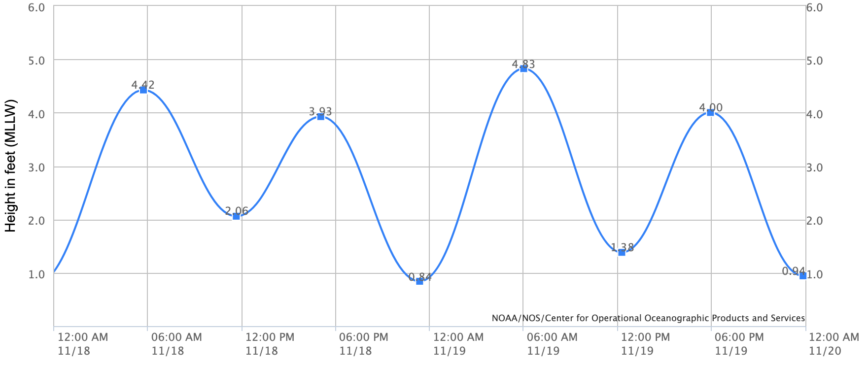
  • And tides are BORING this weekend:
    • 4' at sunrise
    • 2' at lunch
    • and back to 4' at sunset
FORECAST:

Things get interesting next week as the storm track lowers slightly and high pressure lets a few more storms take aim at us- without sending rain. 


The WNW mentioned above for Sunday evening fills in Monday, peaks Tuesday, and holds into Wednesday. Look for shoulder high sets in N County SD and head high surf in southern SD. 


Further out, a good looking storm is forecasted to take shape mid-week and we could see overhead sets from the WNW late next weekend- and possibly the return of the Emergency Board Riding System. About time. 

WEATHER:


Santa Ana winds were a little stronger than I expected yesterday but the recent rains mitigated the fire danger. Unfortunately, we have more Santa Ana winds forming and should arrive Friday into Saturday. Temps through the period should be high 40's at night and high 60's during the day. And the rest of next week looks mellow with no rain in sight. Make sure to follow North County Surf on Twitter!

BEST BET:


Lots of choices here: Saturday with offshore winds and fun WNW. Or Tuesday/Wednesday with better WNW. Or maybe next Sunday withe solid WNW and the EBS in operation?

NEWS OF THE WEEK:


The Pacific islands- Hawaii, Tahiti, Fiji, etc.- have a TON of good waves, but sometimes finding one to yourself is near impossible. But fear not! New waves are being created as we speak. Well actually, it may take a few thousand years before they're rideable, but at least it's a start. Here's the story from NBC News:

A remote undersea volcano is believed to be erupting in Pacific Ocean. Scientists think the Ahyi Seamount's explosions began in mid-October, but it's difficult to confirm because the site, about 3,800 miles west of Honolulu, is so hard to reach.

All indications are that the Ahyi Seamount began erupting in mid-October, the U.S. Geological Survey said Monday. The Northern Marianas are about 3,800 miles west of Honolulu. Scientists are looking to see if the activity is shallow earthquakes or if material exploded from the crater, said Matt Haney, a USGS research geophysicist. Scientists are checking satellite data to see if there’s discolored water, which could suggest material is coming out of the volcano, he said.

“There’s nothing right now that suggests that this eruption will intensify and become a large eruption,” Haney said. Still, mariners would want to avoid the immediate area, he said.


Activity from an undersea volcanic source was picked up last month by hydroacoustic sensors some 1,400 miles away at Wake Island.

With help from the the Laboratoire de Geophysique in Tahiti and data from seismic stations in Guam and Japan, scientists analyzed the signals to determine the source of the activity was probably Ahyi Seamount, the USGS said in a statement.

Activity has been declining in recent days, the statement said.
Ahyi seamount is a large conical submarine volcano. Its highest point is 259 feet below the surface of the ocean. It’s located about 11 miles southeast of the island of Farallon de Pajaros, also known as Uracas.

“There are no local monitoring stations near Ahyi Seamount, which limits our ability to detect and characterize volcanic unrest there,” the agency said. “We will continue to monitor available remote hydrophonic, seismic, and satellite data closely.”

The seamount is part of the Mariana Volcanic Arc, which is a chain of more than 60 active volcanoes stretching over 600 miles west of and parallel to the Mariana Trench, the world’s deepest point.

BEST OF THE BLOG:


Calling our surfers: Time for the next North County Board Meeting Surf Meeting! Good weather has finally returned and we'll be meeting tomorrow- Friday, November 18th. We're going to mix it up this time and get some waves at South Ponto from 7 to 9 AM. So come on down to grab a bite before work, slip into a barrel or two, and learn how you can help the community at our next charity event (which happens to be at Pacific Coast Spirits next month but you'll get the 411 at the Surf Meeting). Look for the tent as usual.

And if you're unfamiliar with the North County Board Meeting, we've been around for 8 years and were created by business professionals who also happen to surf. Our goals are:
  • Encourage the growth of businesses
  • Being a resource for networking
  • Giving back to the community
  • All at the same time making an excuse to surf
You can find out more about our group and events here.

Thanks for the support and we'll see you at Ponto Friday! 

PIC OF THE WEEK:


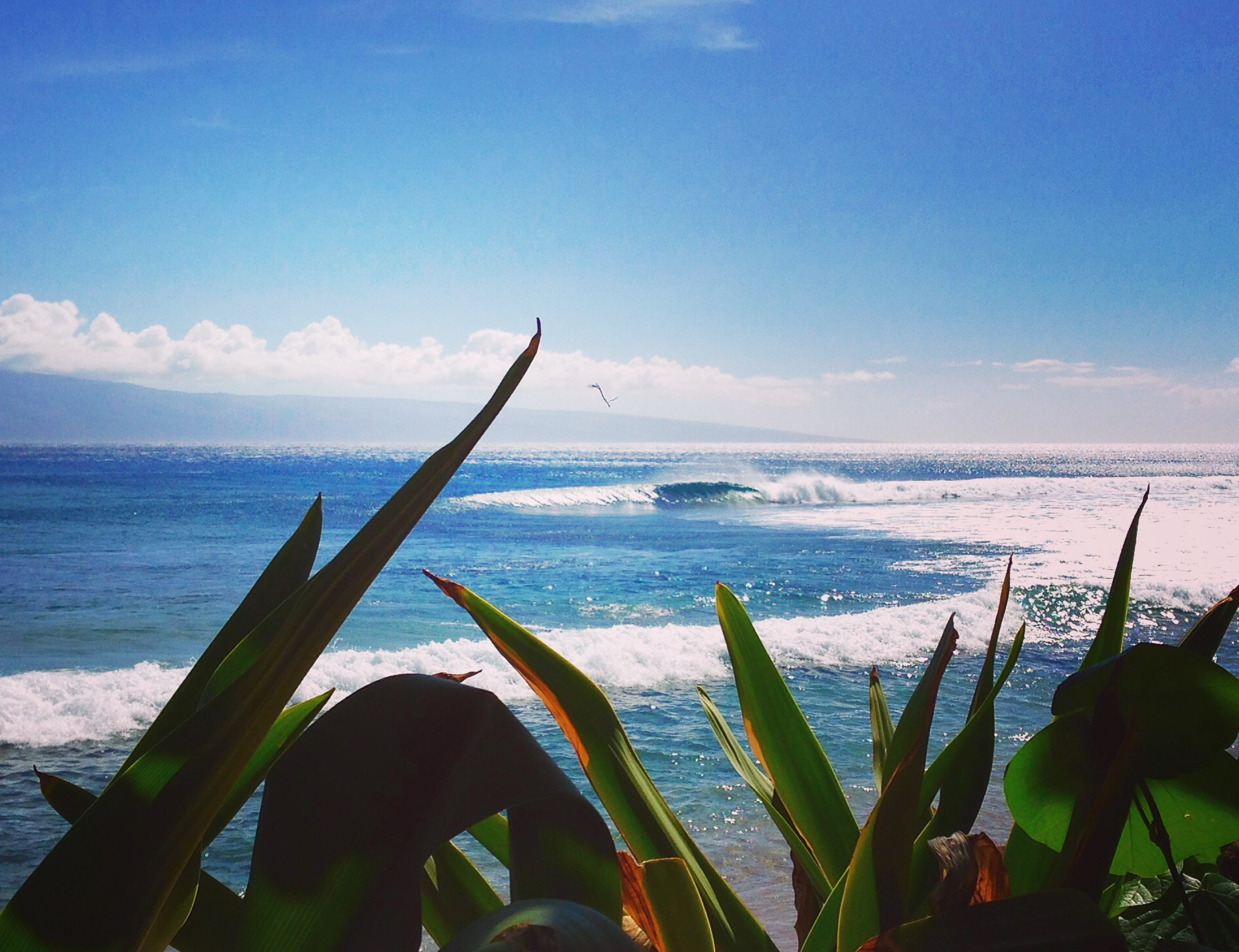
Took this pic on vacation a few years back. Even though I'm not going back anytime soon, I can't tell you where it's at. Ever see that episode of the Brady Brunch where Greg surfed in Hawaii and wore the voodoo tiki idol around his neck? Don't want that kind of bad karma happening to me. 

Keep Surfing, 
Michael W. Glenn
From Zero To Hero
Announcing My Bid For the 2032 Presidential Election
Most Searched Surfer On AOL

Thursday, November 10, 2022

THE Surf Report


And That's A Wrap!

SURF:

Well, wasn't that impressive. And we're still 6 weeks away from winter! A solid storm wreaked havoc along the Western U.S. and Southern California was no exception. 


As far as the surf went, the storm unfortunately came out the N so we didn't see a lot of groundwell from it- just windswell. The past few days have been cleaner BUT the water's been dirty due to the rain. 


No fear though, by the weekend, we should see cleaner water and a new little SW filling in for Friday/Saturday. We're pretty late in the season, so don't expect much, but spots in far N SD should be waist high with the odd chest high set in the OC. 


SD will get in on the action though by Sunday as NW windswell picks up from a trough moving by to the N. Look for chest high sets and maybe a bit of wind. And here's the tides, sun, and water temps for the next few days:
  • Sunrise and sunset for the weekend:
    •  6:17 AM sunrise (that's early)
    •  4:49 PM sunset (that's early) 
  • Water temps are where they should be this time of year- around 62
  • And tides are this weekend are:
    • 4' at sunrise
    • 5' late morning
    • down to 0' at sunset
FORECAST:


The N Pacific is officially awake. After the NW windswell on Monday, we get a fun NW groundswell on Monday/Tuesday. Look for chest high sets in N County SD and shoulder high waves in southern SD. 


The rest of the week is on the small side but we have WNW swell filling in next weekend for shoulder high surf in N SD and head high surf in S SD. If having to wear a 3/2 is the price to pay for fun NW swells, I'm happy to be broke. 

WEATHER:


What originally looked to be a run of the mill cold front on the forecast charts last week, turned into a full blown barn burner on Tuesday (more on that below). In its wake is cool sunny skies for Friday/Saturday and a bit more clouds/wind on Sunday. Next week we have more cold fronts moving by to the N of us which may give us off and on offshore flow. No real Santa Ana winds but we will have sunny skies most of next week. Temps for the foreseeable future look to be low 60's during the day and high 40's at night. Make sure to follow North County Surf on Twitter!

BEST BET:

Monday/Tuesday with fun NW or next weekend with a better angled WNW for us. 

NEWS OF THE WEEK:


So much for that 'weak' cold front I forecasted for last Tuesday. Within a few days of posting that miscalculation, we were treated with a mid-January haymaker. Here's the report:
  • 6-9" of rain in the San Bernardino Mountains
  • 6-8" of snow at Big Bear
  • 1-1.5" of rain along the SD coast
  • wind gusts of 45 mph along the coast
  • and anywhere between 70-100 mph gusts of wind in the local mountains
  • Sierras also got roughly 4' of snow and most resorts are opening early
Does this mean the drought is over? Nope. Does this mean La Nina is a bust? Nope- but there has been on rare instances where we see above average rainfall during La Nina years. But don't bet the house on it. So where do we stand with rainfall so early in our season?
  • Newport Beach: As of last week, they had 0.48" of rain- only 81% of normal. Now they have 1.59" and are 221% of normal. Take that with a grain of salt though as they're aiming for 11.18" by season's end.
  • Oceanside: As of last week, they had 0.43" of rain- only 62% of normal. Now they have 1.83" and are 226% of normal with a goal of 11.86" to hit 'average' by season's end.
  • San Diego: As of last week, they had 0.16"- just 30% of normal. Now they're at 1.16" and 171% of normal (with average at season's end being 9.79").
No rainfall is forecasted in our near future but some models are hinting storms in the Pacific may push our high pressure aside and we could see rain again Thanksgiving week. Awesome.

BEST OF THE BLOG:


Halloween is in the rearview mirror and we've got more holiday spirit in our sights ahead. The North County Board Meeting is in full swing and the next couple of months are going to be BUSY. In particular:
  • NOVEMBER: Time for our next Surf Meeting! We're going to mix it up this time and get some waves at South Ponto from 7 to 9 AM. Set your calendar for next Friday, November 18th to network, grab a bite before work, slip into a barrel or two, and learn how you can help the community at our next charity event. We'll be just south of the south jetty- look for the tent as usual. And speaking of our next charity event...
  • DECEMBER: We're off to Pacific Coast Spirits in South O'side! If you haven't been there yet, you're missing out; great food, great drinks, and great atmosphere. Here's your chance though: Our annual holiday party & charity event will be Thursday, December 15th from 6 to 9 PM. This season we'll be benefiting Sea Trees; helping to protect and restore ocean health (which is important to your health too)! Cost is just $100 per person and includes, appetizers, dinner, and 2 drinks. As usual, space is limited- and we sold out early last year- so reserve your spot asap as it's first come, first serve! To secure your ticket, reach out to either:
    • Rich Clark, rclark@fuzionpayments.com 
    • Michael Glenn, northcountyboardmeeting@gmail.com
In addition to celebrating the holidays at Pacific Coast Spirits, we'll also be having a live auction to benefit Sea Trees- so get ready to battle it out for some great holiday gifts! 

And if you're unfamiliar with the North County Board Meeting, we've been around for 8 years and were created by business professionals who also happen to surf. Our goals are:
  • Encourage the growth of businesses
  • Being a resource for networking
  • Giving back to the community
  • All at the same time making an excuse to surf
You can find out more about our group and events here.

Thanks for your support and we'll see you November 18th AND December 15th! 

PIC OF THE WEEK:


For Thanksgiving, I'll be spending my time along this wave rich coast. For those of you that know, you know. For those of you that don't, let's just say it's sharky (the big ones- not those little So-Cal juveniles), cold, lots of current, the occasional fog bank, and for good reason- fairly empty. That's why I'm bringing my youngest child with me. Misery loves company! For more inspiring shots of California and beyond, check out Todd Glaser's work here.

Keep Surfing, 
Michael W. Glenn
Top Brass
Already Filled Out My Bracket
Refuse To Surf In A Crowd 

Thursday, November 3, 2022

THE Surf Report


'Tis The Season

SURF:
'Tis the season is a phrase you normally hear in December but I'm breaking it out early. Why? Because 'tis the season for the N Pacific to come alive! Whether you're a fan of snow or storm surf, our fall is starting off with a bang. The Sierras and Rockies are getting snow measured in feet, we've already had a couple cold fronts in So-Cal drops some showers, and our attention has turned from SW swells to NW swells.


The past week started clean before a cold front moved in yesterday and gave us 6-8' bumpy surf last night. 


The NW windswell has since subsided to 1/2 of that, but we do have new smaller SW filling in underneath tomorrow. Look for waist to chest high combo swell on Friday with cleaner conditions. That lasts into Sunday morning. And here's the tides, sun, and water temps for the next few days:
  • Don't forget it's daylight saving time this weekend!
    • Sunrise and sunset for Saturday:
      • 7:10 AM sunrise  
      • 5:54 PM sunset 
    • Sunrise and sunset for Sunday:
      • 6:11 AM (surf before work again!)
      • 4:53 PM (yikes that's early!)
  • Take a guess what the NW wind today did to water temps. You guessed it: Dropped it. Water temps are 65 at best in SD and high 50's in LA! 
  • And tides are this weekend are:
    • 5.5' in the morning
    • 2.5' at after lunch
    • and 4' at sunset
FORECAST:

Even though we haven't received a ton of rain so far this fall (more on that below), it's nice to see a string of low pressure systems moving down the coast so early in the season. With that being said... we have another cold front forecasted to move down the coast. 


As it does, look for the NW windswell to pick up again on Tuesday and last through Thursday possibly. Most spots should be shoulder high. 


Further out, models show another storm forming in the N Pacific which could send us more NW mid-month. We may also see some SW groundswell around that time too. Nothing big, but enough to get the OC into the game. 

WEATHER:


Good to see all these cold fronts coming though our area so early in the season. Not a lot of rainfall (more on that below), but it's keeping the Santa Ana winds away. Look for nice cool sunny skies this weekend with temps near 70 along the coast. By Monday, the clouds thicken as the next low pressure system heads our way. Models hint that we may see showers from Tuesday through Thursday. Not a lot of moisture with this system but I'll take it. If anything changes between now and then, make sure to follow North County Surf on Twitter!

BEST BET:

This weekend with chest high sets from the NW/SW or my personal favorite- storm surf on Wednesday! Which oddly enough, is the same thing I said last week. Eerie. 

NEWS OF THE WEEK:


Even though we're in a La Nina weather pattern (less rain than average forecasted for our winter), the early season cold fronts we've been seeing are a sight for sore eyes. The rain the past few days were only a drop in the bucket, but here's some totals:
  • Upper elevations of the San Bernardino Mountains: 4-8" of snow
  • Lower elevations of the San Bernardino Mountains: 2" of rain
  • SD/OC coastal areas: 0.15-0.25" of rain
Winds were the real story this morning with gusts of:
  • 50-70 mph in the local mountains
  • 35-50 mph along the coast
So where do we stand with seasonal rainfall? (rainy season runs from October 1st to September 30th):
  • Newport Beach: 0.48", 81% of normal
  • Oceanside: 0.43", 62% of normal
  • San Diego: 0.16", 30% of normal
Hopefully with next week's showers (0.25"?), we'll be closer to 100% of normal for Newport, 75% in Oceanside, and 50% in San Diego. But we're still a loooooong way away from the end of the season (September 30th) and nowhere near our average of 10" of rain. But who's counting?

PIC OF THE WEEK:


This set up is easy like Sunday morning. Especially so this Sunday as we'll have an extra hour of sleep! 

Keep Surfing, 
Michael W. Glenn
Triumphant
Celeb
When I Win Powerball I'm Going To Use It All For R&D On A 1 Mil Solar Heated Fullsuit