Friday, March 15, 2013
THE Surf Report
FUgly = Foggy + Ugly
SURF:
Kind of a bummer week of surf. We had good surf on Sunday to start the week then everything went downhill from there- just small knee high NW windswell mixed with small knee high SW swell. Best combo spots had surf in the waist high+. And if that wasn’t enough, inland was 80 degrees while the beaches were socked in with fog and temps in the low 60’s. Wasn’t really a motivating factor to get out there and rip! Today is marginally better as we have a slight uptick in the SW swell and the small NW should pick up more tomorrow. Most spots everywhere today are waist high+. The low clouds/fog will also stick around all weekend.
For tomorrow look for the NW to pick up some more and the SW to peak. Best spots should have inconsistent chest high sets. For Sunday the SW will hang around and the NW windswell will pick up again slightly for consistent chest high sets. Nothing big this weekend but the beachbreaks may have some small fun combo peaks. Water temps are inching up to 58 and tides the next few days are 1' at sunrise, up to 3.5' at lunch, and down to 1' again at sunset. Make sure to keep up to date on the waves/weather at Twitter/North County Surf.
FORECAST:
After a little weekend of waves, the NW starts to back off on Monday and looks pretty small from that region next week. Maybe we'll get a little NW windswell towards next weekend but it's not looking too exciting. The southern hemisphere though is really starting to come to life- just in time for spring.
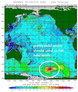
Charts had a good little storm form a few days ago and we should get a chest high swell in north SD county towards Tuesday with the OC getting some shoulder high sets. That storm is now reforming and trying to make itself into a solid swell maker with seas at the center around 40'. If everything holds together, we should get head high+ waves for north SD county around the 22nd with sets overhead+ in the OC. Keep your fingers crossed. After that the southern hemisphere takes a breather.
WEATHER:
Did I ever tell you how much I hate fog? I like great sunny beach weather or stormy as hell. Fog falls somewhere in-between and is a real downer. Unfortunately, that's the forecast for the next 5 days- low clouds and fog and probably not breaking up at the beaches. Temps will be in the low 60's too. Models hint at rain moving in towards Wednesday evening so I'm hoping the forecast holds up!
BEST BET:
If that storm in the southern hemisphere holds together, and the rain ends by Thursday, then next Friday should be good...
NEWS OF THE WEEK:
What's going on in the world of weather? Let's take a look back at some recent history as well as some odd events...
•The combined average temperature over global land and ocean surfaces for February 2013 tied with 2003 as the ninth warmest on record, at 1.03°F above the 20th century average of 53.9°F.
•The global land surface temperature was 1.80°F above the 20th century average of 37.8°F, tying with 2010 as the 11th warmest February on record. For the ocean, the February global sea surface temperature was 0.76°F above the 20th century average of 60.6°F, making it the eighth warmest February on record.
•The combined global land and ocean average surface temperature for the December–February period was 0.92°F above the 20th century average of 53.8°F, making it the 12th warmest such period on record.
•The December–February worldwide land surface temperature was 1.28°F above the 20th century average, tying with 1992 as the 15th warmest such period on record. The global ocean surface temperature for the same period was 0.77°F above the 20th century average and was the eighth warmest such period on record.
•The combined global land and ocean average surface temperature for the January–February period (year-to-date) was 1.01°F above the 20th century average of 53.8°F, tying with 2005 as the ninth warmest such period on record.
2008: A funnel cloud was observed southwest of Balboa Park just east of Downtown San Diego
1987: Widespread strong storm winds pushed gusts to 40 mph at San Diego. Power outages occurred all over the San Diego metro area. Motor homes toppled in the desert. Boats flipped over in harbors. Catalina cruise ships were delayed, stranding 1,200 tourists there.
1986: Heavy rain and snow that started on this day and ended on 3/16 caused mud slides along the coast in Orange County. Three feet of snow fell in the San Bernardino Mountains.
1905: 0.94 inch fell in San Diego in 30 minutes, the greatest 30 minute rainfall on record.
BEST OF THE BLOG:
More signs the recession is over- or at least businesses are betting on the near future- more housing developments in north county SD. Looks like that massive lot in NW Leucadia (about a block south of Ponto and a block north of the little skate park) is finally being built. Almost 10 years in the making. Check out the details on the North County Surf blog. And of course a mid-week Surf Check AND an in-depth THE Surf Report; all of that and more in the blog below!
PIC OF THE WEEK:
Just another random point in the Canary Islands. Eureka!
Keep Surfing,
Michael W. Glenn
Player Hater
Working for Free at the TSA 'Cause I Love to Frisk
The 'G' in G-Land Stands For Glenn


