It's finally starting to feel like winter around here- even though we're a couple weeks away from the official start. Had solid NW swell last weekend and it started to fall apart the past few days- first the NW dropped and now the weather has taken a turn for the worse. We've got clouds, south wind at 20, and a chance for showers tonight.
Good news is that the NW groundswell/windswell is picking up with chest high sets. Bad news of course is the stormy conditions. Along with the extreme tide swings, it's hard to find a rideable wave out there.
Look for the NW to continue to build tonight with head high sets tomorrow along with windy conditions from the NW as the cold front departs the area. Thursday looks to be cleaner with waist to chest high waves. Friday should be pretty small and sunny.
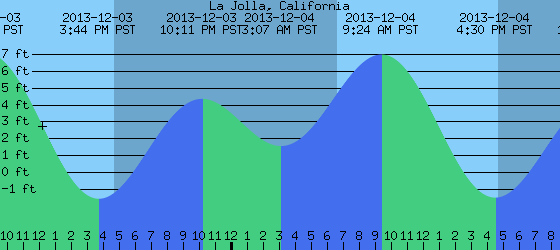
Water temps are still holding at a reasonable 62 degrees and the tides the next few days are pretty brutal- about 3' at sunrise, up to 7' at 10am, and down to -1' at sunset. That's an 8' tide swing kids.
As far as our weather is concerned, the cold front above us will be more of a wind maker than a rain maker- less than 1/4" of rain is expected- and winds will gust to 25 mph. That will last through tomorrow mid-day then it should start to clear out by Wednesday night. Air temps will be cold- only the high 50's in the day and high 40's at night. Right on it's heels though is the potential for a wetter system for late Saturday. Models show about 1/2" of rain from this storm as well as gusty winds and cold weather again. Things should be clear and dry starting Monday.
With this next storm for Saturday, we're due for more NW stormsurf in the shoulder high range with head high sets in SD. Can't complain- I would rather have junky surf then great weather and no waves.
Long range models show the weather being fairly nice next week and another round of NW swell around shoulder high again towards Wednesday. Hopefully this swell will have cleaner conditions as predicted!