Thursday, December 29, 2022

THE Surf Report


2023 Has Been Awesome So Far!

SURF:

If the end of 2022 is any indication of how 2023 is going to be, then sign me up! 


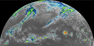
Lots of great surf this past week and manageable weather resulted in good waves up and down the coast. For Friday we have some leftover NW groundswell and a touch of small SW groundswell for chest high+ surf. 


Saturday starts off about the same then our next storm moves ashore that night. Sunday should be a mess with well overhead NW windswell and whitecaps most of the day as the storm exits. And here's the tides, sun, and water temps for the next few days:
  • Sunrise and sunset:
    •  6:51 AM sunrise 
    •  4:53 PM sunset 

  • Water temps are still high 50's
  • And tides are back to normal this weekend:
    • 4' at sunrise
    • 0.5' at lunch
    • and back up to 3' at sunset
FORECAST:


Monday should be a transition day with head high+ NW wind/groundswell then more NW groundswell moves in for head high surf on Tuesday. After that, it looks like we're getting another storm mid-week and that means more sloppy overhead NW windswell. 


Thursday is another transition day and then yep- you guessed it- another storm potentially next weekend. All in all, it's going to take a bit of wizardry to find some clean windows to surf in the middle of all those storms. 

WEATHER:


Impressed yet? Seems like it's been a LOOONG time since we've had a rainy winter; I've forgotten what it's like. As you know by now, we've got another rainmaker headed our way for New Year's Eve. This one looks to be a doozy as models show 1-1.5" of rain by Sunday morning and winds in excess of 35 mph along the coast. We don't even have time to dry out before our next storm arrives mid-week. And if the forecast charts are correct... yet another storm by next Friday! It's still too early to tell how big next week's storms will be, but at least the storm door is open and we have chances of rain. If anything changes between now and then, make sure to follow North County Surf on Twitter!

BEST BET:

Tough to say due to the multiple storms lined up over the ocean like planes coming into LAX. My best guess would be in-between storms- so most likely Friday, Tuesday, and Thursday?...

NEWS OF THE WEEK:


Good start to our winter, eh? As mentioned in previous THE Surf Reports, we are in a La Nina climate pattern in which our ocean temps are cooler than average and it USUALLY results in less rain for us in Southern California. Usually. On the rare occasion though, La Ninas can produce above average rainfall for the season. Since our rainy season officially started October 1st, it's still too early to tell if we'll be above our target of 10", but it's encouraging nonetheless. So here's where we stand so far with our rain totals for the season:
  • Newport Beach: 3.49" so far which is 111% of normal
  • Oceanside: 3.43" so far which is 108% of normal
  • San Diego: 2.71" so far which is 98% of normal
Not to rain on your parade (sorry, bad pun), but last year, Newport had 5" of rain at this point in time (159% of normal), Oceanside had 5.13" (161%), and San Diego 3.32" (120%) and you know how that story ended- by the season's wend we were well below average and our drought persisted. So it's anyone's guess if this La Nina will be typical (below average rain) or if it will flip the script and we end up with above average rain and will put a dent in our drought. If the storms in the next 7 days though actually deliver, we could see over 3" of additional rain when it's all said and done which would really be a good start and 2023 in general. 

PIC OF THE WEEK:


Everything in life is about making the right choices. Like these waves here. Do you play it safe and surf the inside mush or do you throw caution to the wind and paddle over the ledge on that outside drainer. In 2023, I hope you pick the obvious answer. 

Keep Surfing, 
Michael W. Glenn
Ageless Wonder
Father Time
Only Surfer To Win Titles In The IPS, ASP, and WSL Tours

Thursday, December 22, 2022

THE Surf Report


The Best Things In Life Are Free

SURF:


For being loyal THE Surf Report readers all these years, I was going to get you all a brand new shiny surfboard for Christmas. But I thought- you know what- the best things in life are free. And for the Shredder that has everything- I thought the gift of waves was more appropriate. So for the holidays, I'm giving each and everyone one of you the Joy of Surf (I'm trademarking that by by the way). Which is invaluable considering how flat it's been recently. Now, no need to thank me, just make sure you get out there and RIP! (And don't snake me). 


First up is a W swell which will fill in Friday afternoon to the chest high range. That will last until Sunday morning. We also have small late season S swell in the waist high range for all you OC fans. Weather is also looking good with light winds and temps in the low 70's all weekend. And here's the tides, sun, and water temps for the next few days:
  • Did you notice our days are getting longer? Yep- the winter solstice was yesterday and the sun is staying out longer (only 1 minute longer than last weekend, but still):
    •  6:49 AM sunrise 
    •  4:49 PM sunset 
  • Water temps are a chilly 59 degrees.
  • And in addition to the fun surf I'm gifting you, here's some extreme tides you'll find in your stockings:
    • 5' at sunrise
    • almost 7' mid-morning
    • and almost -2' at sunset
    • that's about a 9' tide swing! You can't tell me that's not impressive.
FORECAST:

May have to turn on the ol' Emergency Boardriding System next week as we've got a couple good swells on the charts- and maybe some showers?... 


Look for more W swell to fill in Monday afternoon for chest high+ surf in N County SD (and bigger in S County SD). Tuesday looks to be shoulder high and Wednesday looks to have head high sets. 


We also have a late season S swell forecasted to arrive mid-week. The OC will see most of it (chest high+) but impressive nonetheless for this time of year. 


Beyond that, models show more W swell taking aim at us for shoulder high+ surf towards New Years Eve. The only fly in the ointment is that the storm door may be open and we could see showers or rain the 2nd half of next week (maybe as early as Tuesday evening). Guess you can't have your fruitcake and eat it too. No complaints from me though- I'd rather have surf & showers than flat waves & fine weather. 

WEATHER:


There's been a lot of talk recently about people leaving California. And I have no opinion one way or another. Sure it's expensive here and there's a lot of great places to live in this world. BUT... have you seen the Arctic blast that's hitting the majority of the country this week? One of my favorite spots to visit, Montana, was -35 degrees last night and today the high is only -20 (that's not a typo). It's so cold that the ski resorts are even closed out of an abundance of caution. Meanwhile... here in Southern California it's supposed to be... 75 degrees on Christmas. So we have that going for us. You know what I always say though- we sure could use some rain around here. Luckily, for a variety of reasons, looks like rain could be in our near future. Models are predicting another atmospheric river to slam into Northern/Central California next week which would maybe give us showers down here by Tuesday evening/Wednesday. After that, the storm door may be open for us to get more substantial rain the 2nd half of next week. Changes look to be happening in our atmosphere, so make sure to follow North County Surf on Twitter!

BEST BET:
Most likely this weekend if the anticipated wet weather should arrive next week. Or mid-week if the rain isn't that bad...

NEWS OF THE WEEK:


Storms are the lifeblood of surfing. And consistent surf is the holy grail; kind of like wave pools being our nuclear fusion breakthrough. Kind of. Anyway, certain parts of the world get more consistent surf than others, and some hemispheres are stormier than others. At least that's the findings from the journal PNAS (Proceedings of the National Academy of Sciences). Here's what they had to say:

Researchers say they now know why the Southern Hemisphere is so much stormier than its northern counterpart, adding their discovery could help explain future climate change projections.

A study in the journal PNAS focuses on scientists’ use of satellite data to build a climate model that factored in topographic and ocean circulation data. The researchers studied what happened to the model’s weather patterns when those variables were adjusted.

When the scientists removed topography like mountains from the model, the Northern Hemisphere got stormier, decreasing its difference in storminess compared with the Southern Hemisphere by about half. Ocean circulation mattered, too: When it was removed from the model, it also halved the difference between hemispheres.

The study also offers an explanation for the increase in Southern storminess since the beginning of satellite observations in the 1980s.


As carbon dioxide in the atmosphere increases, so does sea ice loss and sea surface temperature in the Northern Hemisphere. This effect cancels out changes in northern oceans, the researchers write. Meanwhile, the ocean currents that drive storms don’t change in the Southern Hemisphere because its sea ice isn’t melting at the same rate as CO2 levels rise. This helps drive the resulting imbalance between storminess in the North and South.

Overall, the researchers found that the Southern Hemisphere is 24 percent stormier than the Northern Hemisphere on average. In a news release, study author Tiffany Shaw, a climate scientist at the University of Chicago, says understanding the difference in hemispheres will help researchers as human-caused climate change speeds up.

“By laying this foundation of understanding, we increase confidence in climate change projections and thereby help society better prepare for the impacts of climate change,” she says. Researchers predict that as climate change continues worldwide, extreme weather events will increase as well.

So there you have it: If you're looking for more storms and more surf, head to Indo, Australia, or Peru. Sorry Cali, France, and the Outer Banks; better luck next time. 

PIC OF THE WEEK:


Pop Quiz! Today's Pic of the Week is...
  1. Baja California
  2. Morocco
  3. Italy maybe...
  4. Or Swami's before they put sprinklers on the bluff
Keep Surfing, 
Michael W. Glenn
Jolly
Spoiler Alert: I'm Santa
Staying At The Island Of Misfit Toys Surf Camp With Charlie In The Box

Thursday, December 15, 2022

THE Surf Report


In Due Time

SURF:


This past week was a waiting game. Waiting for the water and weather to clean up and not waiting too long for the swell to drop. The past couple of days have had clean conditions and water, but minimal surf. That's going to the story this weekend unfortunately as high pressure is shutting out our storm window. 


We did though have a couple little storms in the N and S Pacific a few days ago, so look for best spots to be waist high. Bam! And here's the tides, sun, and water temps for the next few days:
  • Sunrise and sunset for the weekend:
    •  6:44 AM sunrise 
    •  4:45 PM sunset 
  • Water temps are now high 50's. Welcome to winter!
  • And high tides this weekend are mellow:
    • 3.5' at sunrise
    • 1.5'  late morning
    • and about 3.5' at sunset
FORECAST:
The work week starts out the same unfortunately with small conditions but at least the weather will be nice. 

Models do though show activity happening off Japan/below the Aleutians early in the week which would bring good WNW long period groundswell towards the weekend. But until then, get some holiday shopping done. 

WEATHER:


Our weather this fall and winter has been feast or famine but it is helping us stay above average. Most spots in the OC coastal strip received over 1.5" of rain while SD floated in the 1" range. The Big Bear region even saw up to 1' of snow, so that was a blessing. For the upcoming weekend and week, high pressure is in control and blocking storms in the Pacific, so we're high, dry, and cold. Models even show the nice weather lasting through year end but anything can change between now and then- so make sure to follow North County Surf on Twitter!

BEST BET:

Nothing until late next week unfortunately. And that's IF the anticipated storms develop in the Pacific early next week. 

NEWS OF THE WEEK:


Good to see whitecaps and wet weather early last week. Now we're back to glassy conditions and no surf to go along with it. So until then, let's enjoy...

THIS WEEKEND IN WEATHER HISTORY!

1967: A period of snow began on 12/13 and ended on 12/19. The entire period of snow brought 50 inches to Mt. Laguna, 38 inches in Idyllwild, two feet to Palomar Mountain, and 12 to 18 inches to the higher elevations. One freezing death resulted, numerous schools and highways were closed, transportation was disrupted and there were power outages.

1970: A series of storms brought heavy rain and snow to the region starting 12/17 and ending on 12/22. 7.03 inches of precipitation was recorded in Palomar Mountain, 6.93 inches in Lytle Creek, 6.35 inches in Lake Arrowhead, 5.38 inches in Idyllwild, 4.72 inches in Big Bear Lake, 2.81 inches in San Bernardino, 2.67 inches in Santa Ana, 2.27 inches in Riverside, and 1.84 inches in San Diego. Several roads were flooded and washed out in the northern Inland Empire, exacerbated by the extensive burn areas from earlier in the fall. Snowfall amounts were 32 inches in Idyllwild, 28 inches in Big Bear Lake, 26 inches in Palomar Mountain, and 24 inches in Lake Arrowhead

2008: A snowstorm of a magnitude that hadn't occurred since 1979 descended on the mountains and high deserts from 12/15 to 12/18. Impressive snow totals include 54 inches at Big Bear, almost 36 inches at Wrightwood, 20 inches at Pinon Hills, and 16 inches at Hesperia, Idyllwild and Julian.

2010: A very wet period began on this day and continued through 12/22 as strong westerly flow across the Pacific tapped a pool of deep subtropical moisture near Hawaii, resulting in days of moderate to heavy rainfall. Four to 12 inches of rain fell in the coastal and valley areas over six days, 12 to 28 inches in the mountains, up to nine inches in the high desert and less than four inches in the lower desert. Major landslides and flash flooding impacted the communities of Laguna Beach, Apple Valley, along the Whitewater Channel in the Coachella Valley near Palm Springs, Highland, Corona, Loma Linda, La Jolla, and the city of San Diego from 12/21 to 12/22. Qualcomm Stadium was flooded, but was miraculously drained and prepared for the Poinsettia Bowl held there on 12/23. Heavy wet snow accumulated above 6500 feet with amounts over six inches and as much as two feet above 7500 feet.

December 16th: 

1987: Snow fell for two minutes at Malibu Beach. A foot of snow fell in the mountains north and east of LA. Disneyland was closed due to the weather for only the second time in 24 years. Other theme parks were closed. I-5 and I-15 were closed on stretches through the mountains stranding motorists in the Southland. Numerous accidents killed a few people. Heavy rain hit San Diego County on this day. And 24 inches of snow fell in Julian on 12/16-17 and 9 inches of snow fell at Mt. Laguna.

1988: A strong Pacific storm brought two inches of rain in six hours during the early morning at Mt. Wilson and a storm total of more than 3.5 inches.

2004: Strong offshore winds sustained 51 mph with gusts to 78 mph at Fremont Canyon on December 16th. Gusts reached 69 mph northwest of San Bernardino and 66 mph near Pine Valley. Big rigs were blown over, closing a freeway for a short time. Trees and powerlines were knocked down. The top of a 65-foot Christmas tree at the Victoria Gardens shopping complex in Rancho Cucamonga was snapped off by the winds.

December 17th:

1987: 2.01 inches of rain fell in Oceanside, 2 inches in El Cajon and La Mesa, 1.97 inches in National City, 1.85 inches in Poway, and 1.73 inches at Montgomery Field. Minor flooding occurred in Mission Valley. All schools were cancelled in the mountains of San Diego County.

December 18th:

1984: A major snowstorm that started on this day and ended on 12/19 brought up to 16 inches to the mountains and upper deserts, including 13 inches to Lancaster. Edwards AFB and Interstate 5 (from Castaic to the San Joaquin Valley) were both closed. Freezing fog followed the snow, coating local vegetation with ice.

PIC OF THE WEEK:


Today's Pic of the Week was really hard to find an image of. Namely, it's still heavily localized to this day and is a LOT of work to snag one due to the current. If you know where this spot is, then you know. And if you don't, it's probably best to stick to Beacons on a Wavestorm. 

Keep Surfing, 
Michael W. Glenn
Perceptive
Messi > Mbappe
If There Really Is A Santa, Then He'll Bring Me A 5'4" Machado Mashup

Thursday, December 8, 2022

THE Surf Report


Storm > Surf

SURF:


A little bit of surf earlier in the week has been replaced by sunny skies and a flat ocean. For the upcoming weekend, we get the opposite- building surf but also a building storm. 


On Friday, clean weather hangs around 1 more day and we have a small NNW groundswell filling in for waist high surf and maybe a slightly bigger wave in SD. That peaks on Saturday. 


For Sunday, the storm will be on top of So-Cal and we're due for strong S winds early, switching to W later in the day. Surf will pick up to the head high+ range- but it will be a mess- as well as dirty water. And here's the tides, sun, and water temps for the next few days:
  • Sunrise and sunset for the weekend:
    •  6:40 AM sunrise (6:30 AM paddle out?)
    •  4:43 PM sunset (5 PM paddle in?)
  • Water temps are struggling to stay above 60 
  • And high tides may be an issue this weekend with the impending storm:
    • 4' at sunrise
    • 5.5' mid-morning
    • and dropping to -0.2' at sunset
FORECAST:

Solid wind/groundswell on Monday as the storm exits the region. Look for whitecaps, overhead surf, and the water will probably be a wee bit dirty from the runoff. On Tuesday, the surf will drop to the chest high range and the water will still be contaminated. 


Not much surf mid-week and then models show another storm potentially arriving towards Friday for more waves and wet weather. The storm door is open. Take that La Nina! 

WEATHER:


Nice to see rain headed towards Southern California after the Sierras and Rockies have been getting all of the precipitation from the frozen variety. As mentioned above, we have a good storm moving our way and will increase our cloud cover on Saturday. most of the rain will fall on Sunday with early indications of over 1" along the coast. Monday is a transition day, then the rain may return next weekend. Temperatures for most of the week will struggle to hit 60 and lows at night will be in the mid-40's. Make sure to follow North County Surf on Twitter if anything changes!

BEST BET:

Saturday with small but fun NNW (before the rain starts) or Sunday if you like stormsurf (here's looking at you East Coast transplants) or ditto for next weekend!

NEWS OF THE WEEK:


For being a La Nina year, we sure are lucky to be getting some rain. And is typical this past decade- it's all or nothing. A solid storm in November (1-1.5" along the coast) was replaced by sunny skies and dry conditions. Now a few weeks later, we're due for our next storm- and it's a doozy again with the potential of 1-1.5" along the coast. So with all this rain recently, are we above average? The short answer- we will be. As of today, here's where we stand with our seasonal totals:
  • Newport Beach: 1.71" so far- which is 100% of normal! Last year, they had just 0.80" which was 47% of normal. 
  • Oceanside: 1.84" so far- which is 103% of normal! Last year, they oddly started out fairly well with 1.58", which was 88% of normal. Then it went quickly downhill from there.
  • San Diego: 1.17" so far- which is 73% of normal. Last year at this time, SD had 1.01" which was only 63% of normal.
As you can see, if we get 1-1.5" of rain on Sunday, we'll be well above normal. BUT, as we've seen in the recent past, it may go quiet around here for weeks at a time. Let's think positive though- I really want to turn my sprinklers back on this summer!

BEST OF THE BLOG:


We're just 1 week away from the North County Board Meeting's annual Holiday Party! Thanks to everyone that's reserved a spot so far; and if you haven't yet- time is running out. You just have a couple days to RSVP to this great event benefitting Sea Trees by Sustainable Surf. If you have a passion for the ocean, come join us! We're off to Pacific Coast Spirits in South O'side and if you haven't been there yet, you're missing out; great food, great drinks, and great atmosphere. Here's your chance though: Save the date for Thursday, December 15th from 6 to 9 PM. Cost is just $100 per person and includes, appetizers, dinner, and 2 drinks. To secure your ticket, reach out this week to either:
In addition to celebrating the holidays at Pacific Coast Spirits, we'll be having a live auction to benefit Sea Trees- so get ready to battle it out for some great holiday gifts. 

Thank you for your support as always and we'll see you next week on December 15th!

PIC OF THE WEEK:


Europe is so hot right now. Take the World Cup for instance. With 8 teams left, 5 of them are from Europe! And don't even get me started on Harry Styles. As far as the surf goes, how many rideable spots do you count in this pic?! No wonder everyone I know is moving to Portugal. 

Keep Surfing, 
Michael W. Glenn
Indispensable
Tell Santa I've Been Mostly Good This Year
My Goal Is To Do THE Surf Report Until I'm 100

Thursday, December 1, 2022

THE Surf Report


Winter-lite

SURF:

Sorry for the lack of THE Surf Report last week- I was up N getting some waves! 


But I bet you were too; lots of fun NW last weekend- as well as a better than expected SW- had most of CA in good surf. For the upcoming weekend, we have more waves headed our way (albeit smaller) and suspect conditions. Kind of like winter- but not as big or stormy. 


For Friday, we have steep NW wind/groundswell filling in for chest high surf towards SD. We also have a weak cold front moving through which may whip up the W winds- Saturday is looking better with chest high sets in N County SD and cleaner conditions. Late Sunday sees another round of NW wind/groundswell for chest high sets again (and better in SD) BUT... maybe another weak cold front. And here's the tides, sun, and water temps for the next few days:
  • Sunrise and sunset for the weekend:
    •  6:35 AM sunrise 
    •  4:42 PM sunset  
  • Water temps are struggling to stay above 60 
  • And tides  this weekend:
    • 5' at sunrise
    • 0' at lunch
    • and back to 3' at sunset
FORECAST:

More NNW swells are lined up for the coming week but ideally we'd like to see more W swells that take better aim at us. And not to pile on here- it would also be good to see more groundswell vs. windswell. But beggars can't be choosers. 


With that being said... the NNW from late Sunday will fill in more Monday and peak Tuesday with shoulder high sets. 


The rest of the week looks on the small side but forecast charts show more NNW taking shape in the Aleutians for more shoulder high sets next weekend. Still nothing big but it's technically not winter yet...

WEATHER:


The Pacific NW is getting the lion's share of weather for the next week as the Rockies and Sierras are getting dumped on. Again. Down here- just the tail end of those storms. Look for more clouds tomorrow and maybe a tenth of an inch of rain in far N County SD. Ditto for Sunday. No real storms are forecasted for next week so look for mostly sunny skies and cool temps around 60 during the day and mid 40's at night. Make sure to follow North County Surf on Twitter!

BEST BET:

Saturday with small but fun NNW, or Tuesday with better NNW, or next weekend with yet more NNW. Only chest high+ for the next 7 days but I can't complain- I need the exercise after Thanksgiving.

NEWS OF THE WEEK:


Volcanoes are a blessing and a curse to surfers. If we didn't have volcanoes, we wouldn't have the surf of the Hawaiian Islands or the Indonesian archipelago. On the flip side, volcanoes are extremely destructive, as evident as the eruptions on the Big Island this week. But do we know much about the beautiful beasts? With the help of USA Today, let's test your knowledge...

The largest active volcano in the world is Mauna Loa, among the five volcanoes that make up Hawaii's Big Island. The volcano, rising 13,679 feet above sea level, began erupting late Sunday and prompted officials to warn residents of a worst-case scenario and possible evacuations, according to a USGS Hawaiian Volcano Observatory. 


Mauna Loa is significantly shorter than the tallest volcanoes on Earth by height from sea level. But in terms of volume, Mauna Loa and fellow Hawaiian volcano Mauna Kea, which both have immense size below sea level, are considered the largest volcanoes in the world, according to the Smithsonian Museum of Natural History.

The world's highest volcanoes above sea level are all located in the Andes mountains of South America, but massive oceanic volcanoes dwarf other types in comparison. 

Hawai’i Volcanoes National Park, which calls Mauna Loa the largest active volcano in the world,  has an elevation above the sea floor of about  33,500 feet – with about 19,700 feet of its total elevation below sea level. 

The world's highest volcano above sea level is Nevados Ojos del Salado, which towers nearly 23,000 feet over Chile and Argentina, according to the Smithsonian. Although Mauna Loa is approximately 8,900 feet lower, its height above base is almost 10 times that of the Andean volcano. 


Here are the 20 tallest volcanoes in the world by elevation above sea level, according to Smithsonian:
  1. 22,569 feet: Nevados Ojos del Salado volcano, Chile and Argentina  
  2. 22,110 feet: Llullaillaco volcano,  Chile and Argentina  
  3. 21,844 feet: Tipas, Argentina 
  4. 21,778 feet: Nevado de Incahuasi, Chile and Argentina 
  5. 20,922 feet: Coropuna, Peru 
  6. 20,909 feet: El Condor, Argentina 
  7. 20,787 feet: Parinacota, Chile and Bolivia 
  8. 20,541 feet: Chimborazo, Ecuador 
  9. 20,449 feet: Pular, Chile 
  10. 20,358 feet: El Solo, Chile and Argentina 
  11. 20,253 feet: Sierra Nevada, Chile and Argentina 
  12. 19,997 feet: Aracar, Argentina 
  13. 19,918 feet: Guallatiri, Chile 
  14. 19,915 feet: San Jose, Chile and Argentina 
  15. 19,872 feet: Nevado Chachani, Peru 
  16. 19,787 feet: Socompa, Chile and Argentina 
  17. 19,760 feet: Acamarachi, Chile 
  18. 19,619 feet: Tacora, Chile and Peru 
  19. 19,557 feet: Sairecabur, Chile and Bolivia 
  20. 19,554 feet: Sabancaya, Peru 
But what about the world's tallest volcanoes by height from their sea floor base? A lack of accurate height-above-base data for enough oceanic volcanoes – measured from their constructional bases rather than sea level – complicates scientists' ability to provide a meaningful list, Smithsonian says. 

How many active volcanoes are in the United States? The United States ranks third, behind Indonesia and Japan, in the number of historically active volcanoes – with 161 potentially active volcanoes, according to the USGS Volcano Hazards Program.

About 10% of the more than 1,500 volcanoes that have erupted in the past 10,000 years are in the U.S. – mostly located in the Aleutian and Hawaiian Islands, Alaskan Peninsula, and the Cascade Range of the Pacific Northwest.

BEST OF THE BLOG:


Happy holidays everyone! We are officially in the midst of party season... so it must be time for the North County Board Meeting’s next charity event! We’re off to Pacific Coast Spirits in South O’side and if you haven’t been there yet, you’re missing out; great food, great drinks, and great atmosphere. Here’s your chance though: Save the date for Thursday, December 15th from 6 to 9 PM. This season we’ll be benefiting Sea Trees; helping to protect and restore ocean health (which is important to your health too). This event is open to anyone that appreciates our oceans and the cost is just $100 per person and includes, appetizers, dinner, and 2 drinks. As usual, space is limited- and we sold out early last year- so reserve your spot ASAP. It’s first come, first serve, so to secure your ticket, reach out to either:
  • Rich Clark, rclark@fuzionpayments.com 
  • Michael Glenn, northcountyboardmeeting@gmail.com
In addition to celebrating the holidays at Pacific Coast Spirits, we’ll be having a live auction to benefit Sea Trees- so get ready to battle it out for some great holiday gifts! 

And if you're unfamiliar with the North County Board Meeting, we've been around for 8 years and were created by business professionals who also happen to surf. Our goals are:
  • Encourage the growth of businesses
  • Being a resource for networking
  • Giving back to the community
  • All at the same time making an excuse to surf
You can find out more about our group and events here.

PIC OF THE WEEK:


Is it just me or is everyone sitting too far inside? As the old saying goes, when in doubt, paddle out(side). 

Keep Surfing, 
Michael W. Glenn
Person Of The Hour
Whatever The Opposite Of Lame Is
Patented 584 Surfboard Shapes