
Good To See You Again Ol' Man Winter.
SURF:
From 'summer' to winter in the blink of an eye. Almost 90 degrees on Sunday and down to 60 on Tuesday. I think I got whiplash.
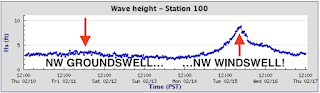
Not much surf to start the week- and a bit of a mess on Tuesday- but lots of fun surf and cleaner conditions returned by Wednesday.

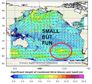
For the weekend we've got leftover NW tomorrow with peaking SW. Not the biggest but expect fun peaky waves most everywhere. For Saturday it's mainly leftover SW/NW for chest high sets and about the same but less consistent on Sunday. And here's the tides, sun, and water temps for the next few days:
- Sunrise and sunset:
- 6:27 AM sunrise (paddle out at 6 AM?)
- 5:38 PM sunset (paddle in at 6 AM?)

- With the NW wind lately, water temps are back to the high 50's.

- And here are the tides this weekend:
- 1' at sunrise
- 4.5' before lunch
- 0' late afternoon
FORECAST:
Might have to turn on the ol' EBS (that's the Emergency Boardriding System for you people in the know) in the near future- but we need to get through a bit of weather first.

On Monday we start to see a new NW fill in later in the day but also winds increase from an approaching cold front. Tuesday looks to be solid but most likely windy and bumpy along with showers. Wednesday is questionable as the front exits the region so it could be clean or it could be bumpy for the head high NW.
We also have a small SW filling in on Wednesday. Thursday may be the day to turn on the EBS as we should have peaking SW and leftover NW for shoulder high waves. Our next small NW looks to be filling in Saturday for chest high waves (bigger towards SD) and about the same Sunday the 27th.


For the long range, the EBS may need to be turned on again and forecast charts show a good NW around Monday the 28th and a good SW towards Wednesday, March 2nd. Let's hope!
WEATHER:

Good to see wind, showers, and snow this week. We've got nice weather this weekend and then more of that wet 'n' windy stuff is anticipated to return next week. Look for the winds/clouds to increase late Monday and then showers most of the day Tuesday. By Wednesday, we should start cleaning up and then it's anyone's guess after that. If anything changes between now and then, make sure to follow North County Surf on Twitter!
BEST BET:
Friday with fun combo swell and great weather. Or next Wednesday with better combo swell BUT suspect winds (or wait until Thursday). OR... good NW 2/28 or good SW 3/2!
NEWS OF THE WEEK:
Whether you believe in climate change or not, you have to admit our weather out West has been WEIRD. Whether it's 90 degree air temps in San Diego for February, or the lack of snow in our mountains this winter, British Columbia seeing Death Valley like temps of 120 this summer, and Colorado seeing wildfires in the middle of winter- we're definitely warming up. And what does a warming Earth mean? Rising sea levels. The National Oceanic and Atmospheric Administration (NOAA) just came out with a report on what to expect the next 20-30 years and it's an eye opener:
Sea level rise is accelerating rapidly and U.S. coasts could on average see another foot of water by 2050, according to a National Oceanic and Atmospheric Administration report released Tuesday.
“The United States is expected to experience as much sea level rise in 30 years as we saw over the span of the entire last century,” Rick Spinrad, the NOAA administrator, said. “Current and future emissions matter, but this will happen no matter what we do about emissions.” The report predicted 10 to 12 inches of additional sea level rise by midcentury, though projections for specific regions and communities vary because of changes in land height. Some parts of the coastal U.S. are subsiding, while others are experiencing uplift or rebound.

Global warming — which is driven by the use of fossil fuels — is the primary cause of sea level rise. Scientists have been observing the trend for decades as water expands because of higher temperatures, as glaciers melt and as ice sheets are diminished. Previous reports have provided broad ranges of how much the seas will rise, but the science is now more specific and can provide a more assertive view of how the world’s coasts will look in a few decades, regardless of future emissions.
“2050 is in our headlights, and we can speak with confidence and clarity about what will occur,” William Sweet, a NOAA oceanographer, said. Rising seas could hamper economies, cause more dramatic flooding, inundate freshwater areas with salt and cause a host of other problems. About 40 percent of the U.S. population lives in a county along the coast.
Coastal flooding risks are expected to rise dramatically by midcentury, the NOAA experts said. “A single flooding event, one that now happens every four to five years on average in coastal communities in the southeast United States, will happen four to five times every year,” Nicole LeBoeuf, an assistant administrator for NOAA’s National Ocean Service, said. So-called sunny day floods — when coasts are inundated not due to storms, but because of high tides — are projected to increase dramatically, too.

The analysis, which was published in cooperation with other federal agencies like NASA, is designed to help communities plan to move vulnerable public buildings away from the coast, prevent construction in areas where inundation is likely and help retrofit homes and other buildings for a flood-prone future.
The data will also help form a baseline for insurance and real estate risk adjustments over sea level rise in the private sector, LaBoeuf said. The report’s findings are based on tide gauge data, satellite data, increasingly powerful climate modeling and other coastal monitoring measurements.
Sea level rise will vary widely by region. The East and Gulf coasts, in general, can expect more sea level rise than average because of coastal subsidence — sinking land. The West coast will see less dramatic changes. Beyond 2050, the possibilities broaden widely and scientists expect the world’s emissions choices to have a substantial impact on the trajectory of rising seas.

The report includes five scenarios for sea level rise by 2100. The lowest limits sea level rise to about two feet in comparison to 2000. The highest scenario predicts more than 7 feet of additional sea level rise since the turn of the millennium. Some climate change processes, such as Antarctic ice sheet instability, are not well understood and scientists acknowledge that there are surprise scenarios that could accelerate how fast seas rise.
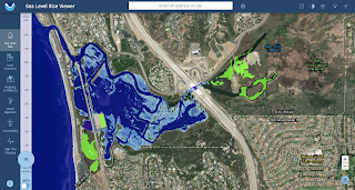
NOAA also just came out with an interactive map to show what your hometown will look like with minimal (1') sea level rise and worst case (10'). Basically the lagoon in Cardiff will look like high tide all the time at a 1' rise and a 10' rise? One big lake with Highway 101 at Georges underwater and the ocean pushing up the lagoon into Olivenhain. Wild. And don't even ask about low lying cities like PB/Mission Beach, the Newport Peninsula, HB, Long Beach...
PIC OF THE WEEK:

As you stare wistfully at this long left in warm tropical waters, consider the small beach bar on land where you can quench your thirst with a frosty beverage at the end of your session. Damn those people!
Keep Surfing,
Michael W. Glenn
Zesty
Least Known Member Of The Brat Pack
Surfed Trestles With Just Me & Zuck Yesterday In The Metaverse
Michael W. Glenn
Zesty
Least Known Member Of The Brat Pack
Surfed Trestles With Just Me & Zuck Yesterday In The Metaverse